Home » Software » R: advanced statistical package » Working with Spatial Data » Converting Alpha-Shapes into SP Objects
Converting Alpha-Shapes into SP Objects
Apr 19, 2010 metroadminJust read about a new R package called alphahull (paper) that sounds like it might be a good candidate for addressing this request regarding concave hulls. Below are some notes on computing alpha-shapes and alpha-hulls from spatial data and converting the results returned by ashape() and ahull() into SP-class objects. Note that the functions are attached at the bottom of the page. Be sure to read the license for the alphahull package if you plan to use it in your work.

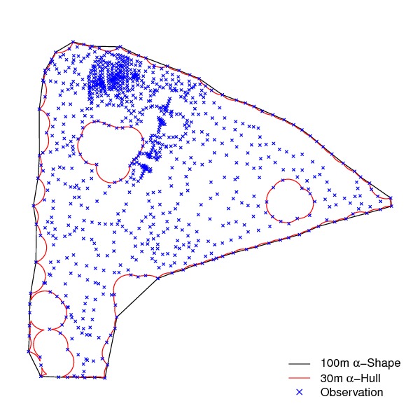
Figure Alpha-Shape Example
## not widely tested!

# need these
library(sp)
library(spgrass6)
library(alphahull)

source('alpha-functions.R')

# read point vector in from GRASS
x <- readVECT6('rtk_pts_5_1')

# extract coordinates
x.coords <- coordinates(x)

# alpha-shape: 100 meter threshold
x.as <- ashape(x.coords[,1], x.coords[,2], alpha=100)

# alpha-hull: 30 meter threshold
x.ah <- ahull(x.coords[,1], x.coords[,2], alpha=30)


plot(x.as, cex=0.5, pch=4, xlab='Easting (m)', ylab='Northing (m)', main=expression(paste('100m ', alpha, '-Shape')), asp=1)

plot(x.ah, cex=0.5, pch=4, xlab='Easting (m)', ylab='Northing (m)', main=expression(paste('30m ', alpha, '-Hull')), asp=1)


## convert into SP objects

# alpha-shape
x.as.spldf <- ashape_to_SPLDF(x.as, proj4string=x@proj4string)

# alpha-hull
x.ah.spldf <- ahull_to_SPLDF(x.ah, proj4string=x@proj4string)

# check: OK
pdf(file='ashape_ahull_demo.pdf', width=6, height=6)
par(mar=c(1,1,1,1))
plot(x.as.spldf)
lines(x.ah.spldf, col='red')
points(x, cex=0.5, pch=4, col='blue')
legend('bottomright', legend=c(expression(paste('100m ', alpha, '-Shape')), expression(paste('30m ', alpha, '-Hull')), 'Observation'), lty=c(1,1,NA), pch=c(NA,NA,4), col=c('black', 'red', 'blue'), bty='n')
dev.off()


# save back to GRASS: OK
writeVECT6(x.as.spldf, 'rtk_ashape')

# save back to GRASS: OK
writeVECT6(x.ah.spldf, 'rtk_ahull')
Attachment: alpha-functions.R
Links:
Working with Spatial Data
Customizing Maps in R: spplot() and latticeExtra functions
Software
- General Purpose Programming with Scripting Languages
- LaTeX Tips and Tricks
- PostGIS: Spatially enabled Relational Database Sytem
- PROJ: forward and reverse geographic projections
- GDAL and OGR: geodata conversion and re-projection tools
- R: advanced statistical package
- Access Data Stored in a Postgresql Database
- Additive Time Series Decomposition in R: Soil Moisture and Temperature Data
- Aggregating SSURGO Data in R
- Cluster Analysis 1: finding groups in a randomly generated 2-dimensional dataset
- Color Functions
- Comparison of Slope and Intercept Terms for Multi-Level Model
- Comparison of Slope and Intercept Terms for Multi-Level Model II: Using Contrasts
- Creating a Custom Panel Function (R - Lattice Graphics)
- Customized Scatterplot Ideas
- Estimating Missing Data with aregImpute() {R}
- Exploration of Multivariate Data
- Interactive 3D plots with the rgl package
- Making Soil Property vs. Depth Plots
- Numerical Integration/Differentiation in R: FTIR Spectra
- Plotting XRD (X-Ray Diffraction) Data
- Using lm() and predict() to apply a standard curve to Analytical Data
- Working with Spatial Data
- Customizing Maps in R: spplot() and latticeExtra functions
- Converting Alpha-Shapes into SP Objects
- Some Ideas on Interpolation of Categorical Data
- Visual Interpretation of Principal Coordinates (of) Neighbor Matrices (PCNM)
- Visualizing Random Fields and Select Components of Spatial Autocorrelation
- Generation of Sample Site Locations [sp package for R]
- Target Practice and Spatial Point Process Models
- Ordinary Kriging Example: GRASS-R Bindings
- Point-process modelling with the sp and spatstat packages
- Simple Map Creation
- Comparison of PSA Results: Pipette vs. Laser Granulometer
- GRASS GIS: raster, vector, and imagery analysis
- Generic Mapping Tools: high quality map production

