Home
SoilWeb Apps
People
Anthony Toby O'Geen
Peter Hartsough
Katelin Alldritt
Jessica Chiartas
Ryan Ferrell
Marai Rodoreda Rossell
Wilson Salls
Zhiyuan Tian
Dylan E. Beaudette
Donald G McGahan
Valerie Bullard
Alexandre Swarowsky
Stewart Wilson
Projects
BMP's for Irrigated Agriculture
Improving Water Quality of Tailwater using Constructed Wetlands
Sediment Control in Irrigated Agriculture
Water Quality Monitoring Projects
Pedology and Soil Survey
Geographic Nutrient Management Zones for Winegrape Production
GIS and Digital Soil Survey Projects
New Technologies in Soil Survey
Other Information
Pinnacles National Monument
Terrain Classification Experiment 2: GRASS, R, and the raster package
Images from Pinnacles Soil Profile Analysis
Accessing PINN Soils Data in Google Earth
Computing terrain-specific slope classes by region
Finding pockets of soil between the Pinnacles
Islands of Fertility: Oak Tree vs. Buckwheat Savannah Soils
Pedon Data collection and entry graphs
Restored 1933 Geologic Map of Pinnacles
Soil Color Ideas
Soil Properties by Parent Material and Rock Type
Some panoramic pictures
Insolation Time Experiments
Rangeland Soil Management and Hydrology
Watershed-scale Hydropedology
Hydrologic Modeling in Oak Woodland Soilscapes
San Joaquin Experimental Range (SJER)
Operations in Range Unit 5-1
Main Characterization and Monitoring Sites
Site Selection Ideas
Terrain Classification Experiments
Topographic Survey
Sensor Installation
SJER Detailed Soil Survey
SFREC
Canopy Quantification via Image Classification
Characterization of Terrain Shape, Microclimate, and Canopy Cover
Elevation Survey by RTK
Estimates of Local Sky Obstruction (Regions of Problematic GPS Reception)
Preliminary Watershed Walk
Establishing the Optimal Number of Survey Points
Regions of like SD(elevation)
Selection by Minimizing MAE (mean absolute error)
Generation of Vegetation Sampling Areas
Conversion of Sampling Blocks to GPS Waypoints
Processing Transect Data
Preliminary Soil Characterization Data
Software
General Purpose Programming with Scripting Languages
Python Image Module Example: How much ink on that page?
LaTeX Tips and Tricks
Customizing BibTeX
PostGIS: Spatially enabled Relational Database Sytem
Importing and Exporting
Example Spatial SQL Operations on Point, Line and Polygon Geometry Types
Affine Transformation Operations in PostGIS
Case Study: Fixing Bad TIGER Line data with R and PostGIS
Comparision with output from v.transform
Higher Order Transformations
Transformation parameters query
User defined Function in PL/pgSQL to compute the transformation parameters
Control Points Table Format
Analysis of SSURGO Data in PostGIS: An Overview
Logistics: Getting Connected and Executing Queries
Getting Parent Material Data out of SSURGO
Checking Type Locations
Learning by Example: Common Queries
Identifying the Largest Components
Profile water storage as calculated from SSURGO
Soil Texture Example
Identification of Dated Surfaces via Soil Series
Seasonally Wet Soils and Shrink-Swell Potential
Making Database Diagrams with PostgreSQL Autodoc
PROJ: forward and reverse geographic projections
GDAL and OGR: geodata conversion and re-projection tools
R: advanced statistical package
Access Data Stored in a Postgresql Database
Additive Time Series Decomposition in R: Soil Moisture and Temperature Data
Aggregating SSURGO Data in R
Cluster Analysis 1: finding groups in a randomly generated 2-dimensional dataset
Color Functions
Convert Munsell colors to computer-friendly RGB triplets
Using ColorBrewer to assist with thematic map color selection
Comparison of Slope and Intercept Terms for Multi-Level Model
Comparison of Slope and Intercept Terms for Multi-Level Model II: Using Contrasts
Creating a Custom Panel Function (R - Lattice Graphics)
Customized Scatterplot Ideas
Estimating Missing Data with aregImpute() {R}
Exploration of Multivariate Data
Interactive 3D plots with the rgl package
Making Soil Property vs. Depth Plots
Numerical Integration/Differentiation in R: FTIR Spectra
Plotting XRD (X-Ray Diffraction) Data
Using lm() and predict() to apply a standard curve to Analytical Data
Working with Spatial Data
Customizing Maps in R: spplot() and latticeExtra functions
Converting Alpha-Shapes into SP Objects
Some Ideas on Interpolation of Categorical Data
Visual Interpretation of Principal Coordinates (of) Neighbor Matrices (PCNM)
Visualizing Random Fields and Select Components of Spatial Autocorrelation
Generation of Sample Site Locations [sp package for R]
Target Practice and Spatial Point Process Models
Ordinary Kriging Example: GRASS-R Bindings
Point-process modelling with the sp and spatstat packages
Simple Map Creation
Comparison of PSA Results: Pipette vs. Laser Granulometer
GRASS GIS: raster, vector, and imagery analysis
GRASS and POVRAY
Compiling from Source Code (notes)
Importing Various Types of Vector and Raster Data
Vector Operations
Traveling Salesman Approach to Visiting Data-loggers II
Traveling Salesman Approach to Visiting Data-loggers
Importing and Exporting from/to a Garmin GPS
Spatial Clustering of Point Data: Spearfish Example
Raster profile along arbitrary line segments
Working with transects
Raster Operations
Using R and r.mapcalc (GRASS) to Estimate Mean Topographic Curvature
Simple Comparision of Two Least-Cost Path Approaches
Mapping Wifi Networks with Kismet, GDAL, and GRASS
Geologic-Scale Erosion
Visual Comparison of 2 Raster Images
Working with Landsat Data
Cartographic Output via GMT
Generic Mapping Tools: high quality map production
Detailed Magnetic Declination
Generic GRASS-GMT Plotting System
Links
Blog
Home
»
Projects
»
Rangeland Soil Management and Hydrology
»
Watershed-scale Hydropedology
»
Hydrologic Modeling in Oak Woodland Soilscapes
»
SFREC
»
Generation of Vegetation Sampling Areas
»
Conversion of Sampling Blocks to GPS Waypoints
Conversion of Sampling Blocks to GPS Waypoints
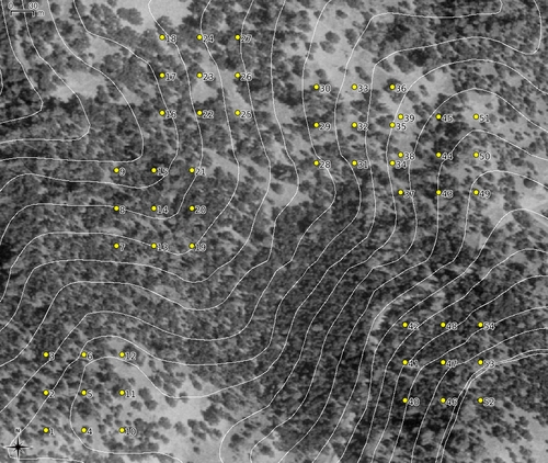
Conversion of Sample Plot Boundaries to Points
Example
Attachment:
veg_points.gpx
simple_map.png
Projects
BMP's for Irrigated Agriculture
Pedology and Soil Survey
Rangeland Soil Management and Hydrology
Watershed-scale Hydropedology
Hydrologic Modeling in Oak Woodland Soilscapes
San Joaquin Experimental Range (SJER)
SFREC
Canopy Quantification via Image Classification
Characterization of Terrain Shape, Microclimate, and Canopy Cover
Elevation Survey by RTK
Generation of Vegetation Sampling Areas
Conversion of Sampling Blocks to GPS Waypoints
Processing Transect Data
Preliminary Soil Characterization Data