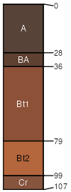
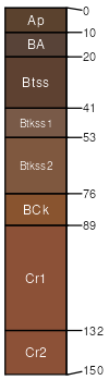
Coyle-Ashport frequently flooded-Ironmound complex, 1 to 8 percent slopes

Coyle (31%)
Loamy Upland
Udic Argiustolls
Well drained
Hydric: No
PAWS: 14 cm
hillslopes / Backslope
Ashport (28%)
Loamy Bottomland
Fluventic Haplustolls
Well drained
Hydric: No
PAWS: 41 cm
flood plains
Ironmound (22%)
Shallow Upland
Udic Haplustepts
Well drained
Hydric: No
PAWS: 8 cm
hillslopes / Backslope
Kingfisher (5%)
Loamy Upland
Udic Argiustolls
Well drained
Hydric: No
PAWS: 13 cm
hillslopes / Backslope
Grainola (5%)
Claypan Upland (North)
Udertic Haplustalfs
Well drained
Hydric: No
PAWS: 11 cm
hillslopes / Backslope
Piedmont (4%)
Claypan Upland (North)
Udertic Argiustolls
Well drained
Hydric: No
PAWS: 16 cm
hillslopes / Backslope
Zaneis (2%)
Loamy Upland
Udic Argiustolls
Well drained
Hydric: No
PAWS: 21 cm
hillslopes / Backslope
Pulaski (2%)
Loamy Bottomland
Udic Ustifluvents
Well drained
Hydric: No
PAWS: 30 cm
flood plains
Masham (1%)
Shallow Clay Upland
Udic Haplustepts
Well drained
Hydric: No
PAWS: 8 cm
hillslopes / Backslope
SSAScalePublishedExport
ok0831:12,00019942023-09-07