| Kingfisher-Vernon complex, 3 to 6 percent slopes | 5424 | 13537 | 1382493 | 1hdlk | ks007 | 1973 | 1:24000 |
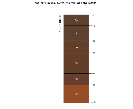
Kingfisher silt loam, 1 to 3 percent slopes | 5422 | 4799 | 1382491 | 30x66 | ks007 | 1973 | 1:24000 |
Kingfisher-Vernon complex, 1 to 3 percent slopes | 5423 | 1195 | 1382492 | 1hdlj | ks007 | 1973 | 1:24000 |
Kingfisher silt loam, 1 to 3 percent slopes | 5422 | 7531 | 3293142 | 30x66 | ks077 | 1965 | 1:24000 |
Kingfisher silt loam, 3 to 5 percent slopes | 5425 | 3363 | 3293149 | 30x68 | ks077 | 1965 | 1:24000 |
Kingfisher-Ironmound silt loams complex, 1 to 5 percent slopes | 5426 | 2423 | 3293153 | 30x69 | ks077 | 1965 | 1:24000 |
Kingfisher-Ironmound complex, 5 to 8 percent slopes, shallow, eroded | KgID2 | 30 | 622376 | nwmn | ok003 | 1971 | 1:24000 |
Kingfisher-Lucien complex, 3 to 8 percent slopes, eroded | KhD2 | 8472 | 381732 | dt6y | ok011 | 1965 | 1:24000 |
Kingfisher silt loam, 1 to 3 percent slopes | KfB | 7022 | 381730 | 30x66 | ok011 | 1965 | 1:24000 |
Kingfisher-Huska complex, 1 to 3 percent slopes | KlB | 1740 | 381733 | dt6z | ok011 | 1965 | 1:24000 |
Kingfisher silt loam, 0 to 1 percent slopes | KfA | 1380 | 381729 | dt6v | ok011 | 1965 | 1:24000 |
Kingfisher-Grant complex, 3 to 5 percent slopes | KgC | 1023 | 381731 | dt6x | ok011 | 1965 | 1:24000 |
Kingfisher silt loam, 3 to 5 percent slopes | KfC | 20186 | 381952 | 30x68 | ok017 | 1972 | 1:24000 |
Kingfisher silt loam, 1 to 3 percent slopes | KfB | 16171 | 381951 | 30x66 | ok017 | 1972 | 1:24000 |
Kingfisher-Ironmound complex, 1 to 5 percent slopes | 9 | 7075 | 382153 | 2tq6c | ok027 | 1984 | 1:24000 |
Kingfisher-Urban land-Ironmound complex, 1 to 5 percent slopes | 28 | 139 | 382095 | 2tq6g | ok027 | 1984 | 1:24000 |
Kingfisher-Ironmound complex, 5 to 8 percent slopes, shallow, eroded | GnD2 | 9974 | 382494 | dv0j | ok047 | 1965 | 1:24000 |
Kingfisher-Ironmound complex, 8 to 20 percent slopes, eroded | GnE2 | 7568 | 382496 | dv0l | ok047 | 1965 | 1:24000 |
Kingfisher-Ironmound complex, 8 to 20 percent slopes | GnE | 7419 | 382495 | dv0k | ok047 | 1965 | 1:24000 |
Kingfisher-Ironmound complex, 5 to 8 percent slopes | GnD | 2701 | 382493 | dv0h | ok047 | 1965 | 1:24000 |
Kingfisher silt loam, 3 to 5 percent slopes, eroded | KfC2 | 2418 | 382498 | 2tq6b | ok047 | 1965 | 1:24000 |
Kingfisher-Ironmound complex, 5 to 8 percent slopes, eroded | KlD2 | 244 | 382499 | dv0p | ok047 | 1965 | 1:24000 |
Kingfisher silt loam, 1 to 3 percent slopes | 24 | 7763 | 382712 | 30x66 | ok053 | 1983 | 1:24000 |
Kingfisher-Wakita complex, 1 to 3 percent slopes | 27 | 4819 | 382715 | dv7n | ok053 | 1983 | 1:24000 |
Grant-Kingfisher complex, 5 to 8 percent slopes, eroded | 21 | 3747 | 382709 | dv7g | ok053 | 1983 | 1:24000 |
Kingfisher silt loam, 3 to 5 percent slopes, eroded | 26 | 2887 | 382714 | 2tq6b | ok053 | 1983 | 1:24000 |
Kingfisher-Wakita complex, 3 to 5 percent slopes, eroded | 28 | 2318 | 382716 | dv7p | ok053 | 1983 | 1:24000 |
Grant-Kingfisher complex, 5 to 8 percent slopes | 20 | 1654 | 382708 | dv7f | ok053 | 1983 | 1:24000 |
Kingfisher silt loam, 3 to 5 percent slopes | 25 | 1299 | 382713 | 30x68 | ok053 | 1983 | 1:24000 |
Kingfisher-Ironmound silt loams complex, 1 to 5 percent slopes | KgIC | 545 | 3293154 | 30x69 | ok053 | 1983 | 1:24000 |
Grant-Kingfisher complex, 5 to 8 percent slopes, eroded | GrKD2 | 8 | 623469 | nxrx | ok071 | 1965 | 1:24000 |
Kingfisher silt loam, 1 to 3 percent slopes | KfB | 24069 | 383393 | 30x66 | ok073 | 1960 | 1:24000 |
Kingfisher silt loam, 3 to 5 percent slopes | KfC | 23443 | 383394 | 30x68 | ok073 | 1960 | 1:24000 |
Kingfisher-Lucien complex, 5 to 8 percent slopes, eroded | KgD3 | 10329 | 383395 | dvyl | ok073 | 1960 | 1:24000 |
Kingfisher-Wakita complex, 1 to 3 percent slopes | KhB | 2691 | 383396 | dvym | ok073 | 1960 | 1:24000 |
Kingfisher-Wakita complex, 3 to 5 percent slopes | KhC | 1127 | 383397 | dvyn | ok073 | 1960 | 1:24000 |
Kingfisher loam, 3 to 5 percent slopes, eroded | KinC2 | 4275 | 383634 | dw69 | ok083 | 1994 | 1:12000 |
Kingfisher silt loam, 1 to 3 percent slopes | KgfB | 824 | 383633 | 30x66 | ok083 | 1994 | 1:12000 |
Kingfisher-Ironmound complex, 5 to 8 percent slopes, shallow, eroded | KgID2 | 50 | 1383569 | 1hfq8 | ok093 | 1965 | 1:24000 |
Kingfisher-Lucien complex, 1 to 5 percent slopes | KgLC | 3636 | 384067 | 2tq6f | ok103 | 1994 | 1:24000 |
Kingfisher loam, 3 to 5 percent slopes, eroded | KinC2 | 2642 | 384070 | dwnc | ok103 | 1994 | 1:24000 |
Kingfisher silt loam, 1 to 3 percent slopes | KgfB | 2583 | 384069 | 30x66 | ok103 | 1994 | 1:24000 |
Kingfisher-Wakita complex, 1 to 5 percent slopes | KgWC | 1226 | 384068 | dwn9 | ok103 | 1994 | 1:24000 |
Kingfisher-Ironmound complex, 1 to 5 percent slopes | KgIC | 1080 | 384313 | 2tq6c | ok109 | 1996 | 1:12000 |
Ironmound-Kingfisher complex, 1 to 8 percent slopes | IrKD | 544 | 384308 | dwx1 | ok109 | 1996 | 1:12000 |
Kingfisher-Urban land-Ironmound complex, 1 to 5 percent slopes | KUIC | 412 | 384309 | 2tq6g | ok109 | 1996 | 1:12000 |
Kingfisher-Loco complex, 5 to 12 percent slopes | Kk | 14291 | 384864 | dxgz | ok137 | 1960 | 1:24000 |