| Gallion and Pulaski fine sandy loams, 0 to 1 percent slopes (rilla, rilla) | GPA | 4496 | 565258 | lz64 | ar017 | 1964 | 1:20000 |
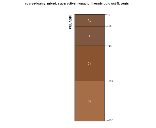
Pulaski fine sandy loam, 0 to 1 percent slopes, occasionally flooded | Pu | 12973 | 381915 | 2s7g6 | ok015 | 1967 | 1:24000 |
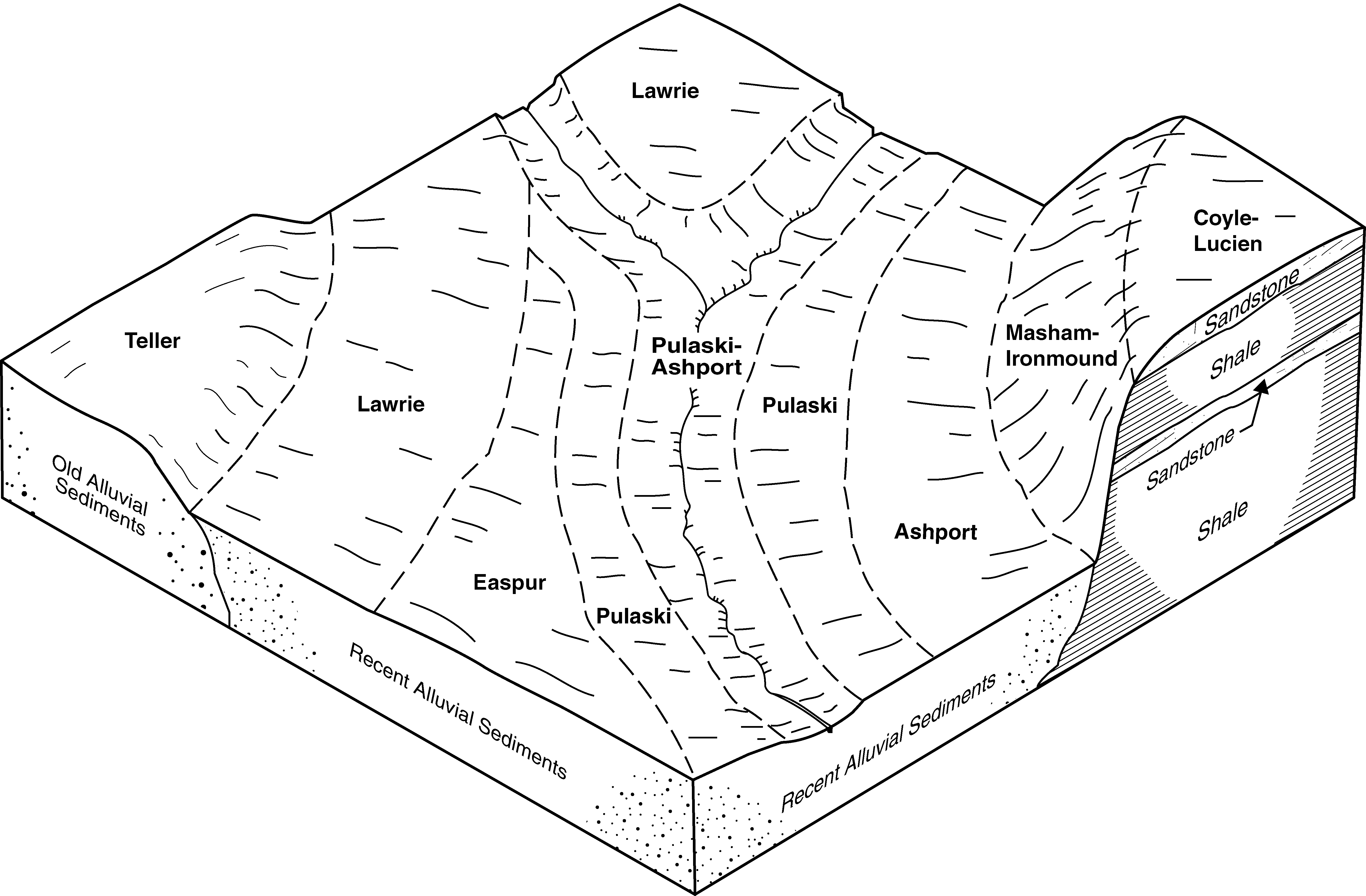
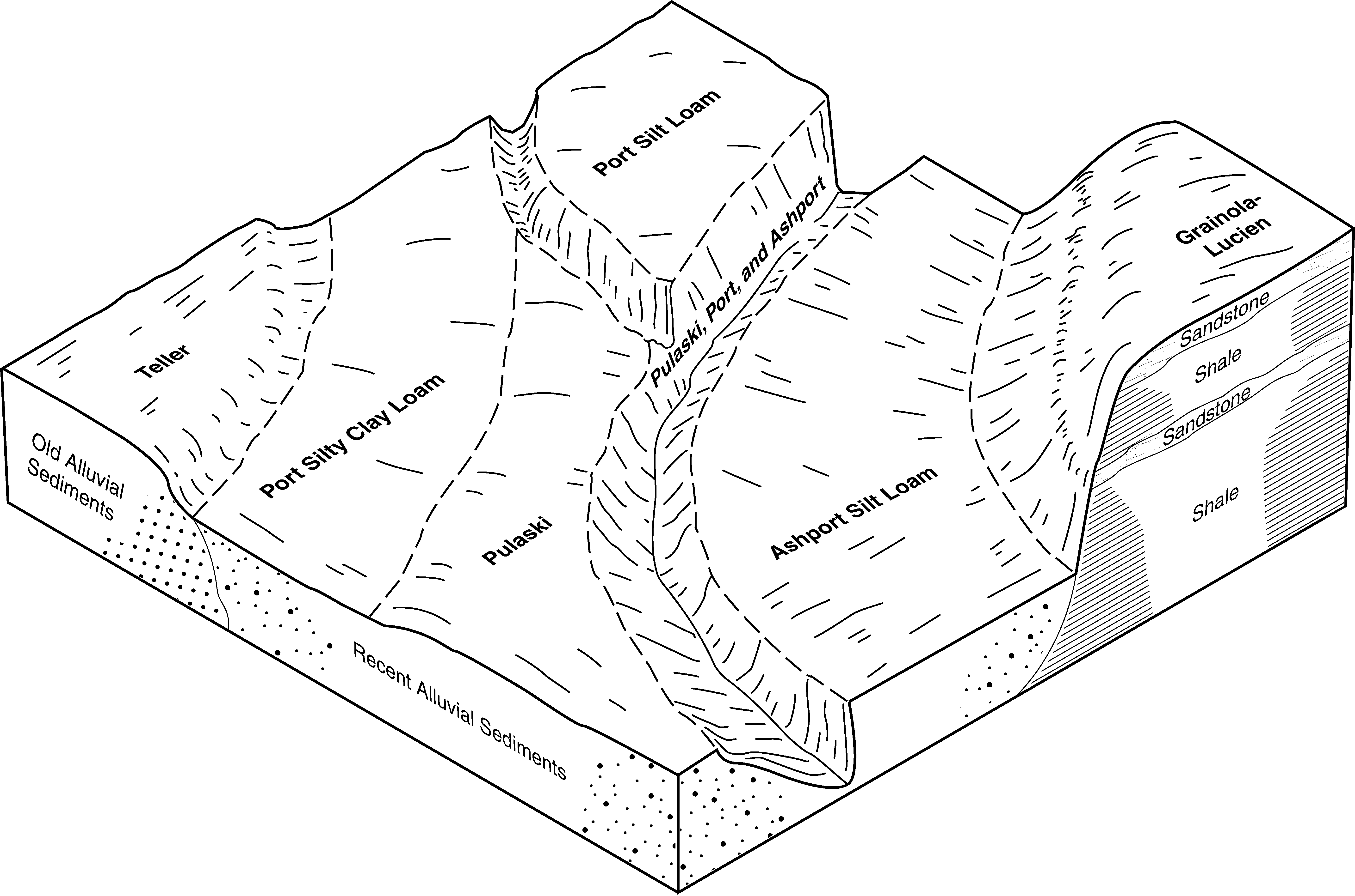
Port and Pulaski soils, 0 to 1 percent slopes, frequently flooded, channeled | Pp | 3019 | 381914 | 2tq6r | ok015 | 1967 | 1:24000 |
Pulaski and Bunyan soils, 0 to 1 percent slopes, frequently flooded | 36 | 31694 | 382020 | dtj7 | ok019 | 1977 | 1:24000 |
Pulaski fine sandy loam, 0 to 1 percent slopes, occasionally flooded | 35 | 6318 | 382019 | dtj6 | ok019 | 1977 | 1:24000 |
Pulaski fine sandy loam, 0 to 1 percent slopes, occasionally flooded | 95 | 7159 | 382159 | 2s7g6 | ok027 | 1984 | 1:24000 |
Pulaski fine sandy loam, 0 to 1 percent slopes, occasionally flooded | Pb | 14013 | 382293 | 2s7g6 | ok037 | 1952 | 1:24000 |
Ashport, Port and Pulaski soils, 0 to 1 percent slopes, frequently flooded | APPA | 304 | 2516362 | 2tq7b | ok037 | 1952 | 1:24000 |
Pulaski and Ashport soils, 0 to 1 percent slopes, frequently flooded | Br | 19601 | 382485 | 30g74 | ok047 | 1965 | 1:24000 |
Pulaski fine sandy loam, 0 to 1 percent slopes, occasionally flooded | Pu | 1421 | 382521 | 2s7g6 | ok047 | 1965 | 1:24000 |
Port and Pulaski soils, 0 to 1 percent slopes, frequently flooded | 58 | 10875 | 382592 | dv3p | ok049 | 1982 | 1:24000 |
Pulaski fine sandy loam, 0 to 1 percent slopes, occasionally flooded | 59 | 5742 | 382593 | 2s7g6 | ok049 | 1982 | 1:24000 |
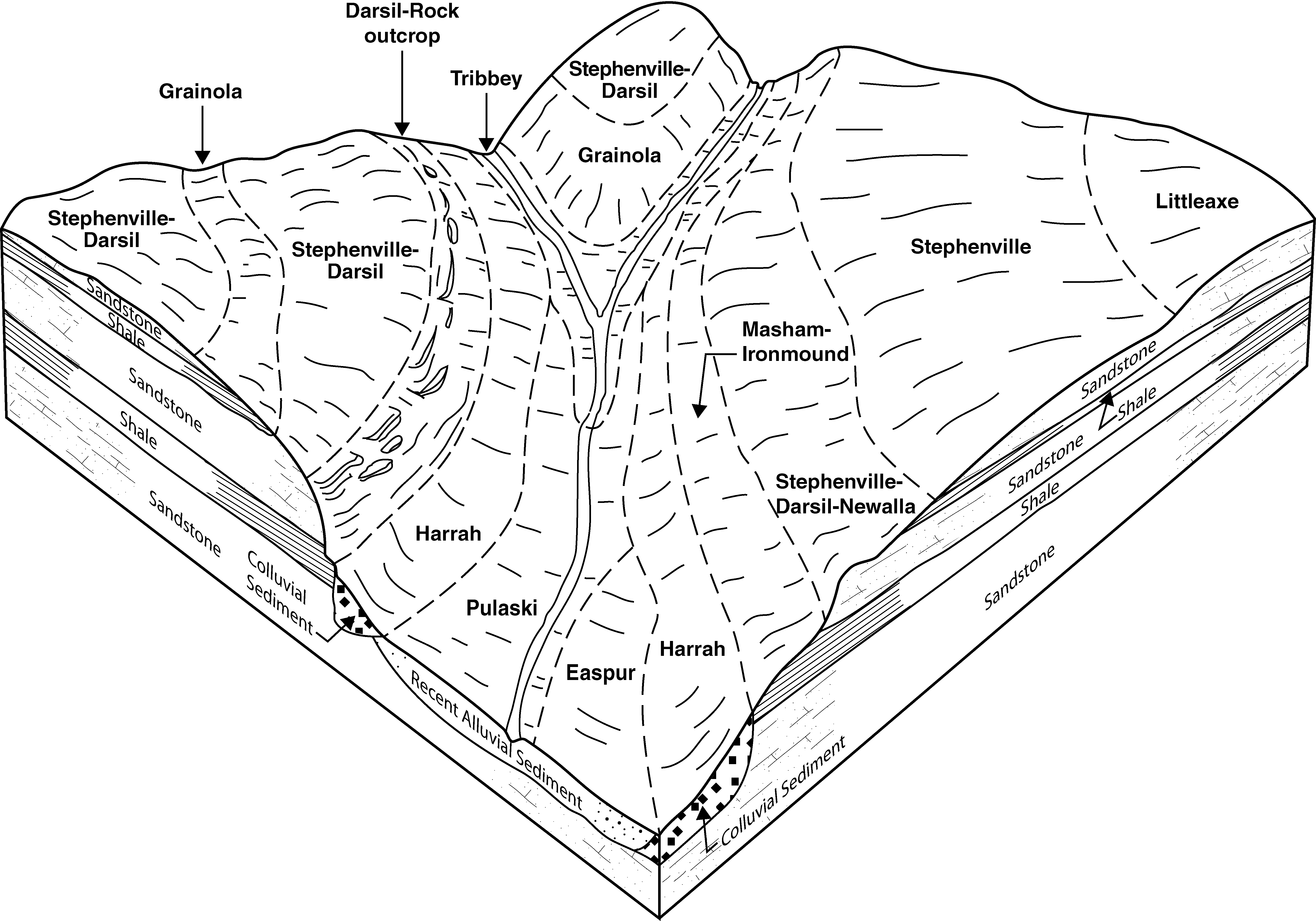
Stephenville-Pulaski, frequently flooded, complex, 0 to 12 percent slopes | 54 | 4436 | 382676 | dv6d | ok051 | 1975 | 1:24000 |
Pulaski fine sandy loam, 0 to 1 percent slopes, occasionally flooded | 41 | 4168 | 382662 | 2s7g6 | ok051 | 1975 | 1:24000 |
Port and Pulaski soils, 0 to 1 percent slopes, frequently flooded, channeled | Pp | 6420 | 383238 | 2tq6r | ok067 | 1967 | 1:24000 |
Pulaski fine sandy loam, 0 to 1 percent slopes, occasionally flooded | Pu | 1925 | 383239 | 2s7g6 | ok067 | 1967 | 1:24000 |
Ashport, Port and Pulaski soils, 0 to 1 percent slopes, frequently flooded | Br | 8631 | 383321 | 2tq7b | ok071 | 1965 | 1:24000 |
Ashport, Port and Pulaski soils, 0 to 1 percent slopes, frequently flooded | Br | 10328 | 383386 | 2tq7b | ok073 | 1960 | 1:24000 |
Pulaski fine sandy loam, 0 to 1 percent slopes, occasionally flooded | Ps | 26350 | 383526 | 2s7g6 | ok081 | 1966 | 1:24000 |
Easpur loam, 0 to 1 percent slopes, occasionally flooded | Po | 18969 | 383525 | dw2s | ok081 | 1966 | 1:24000 |
Ashport, Port and Pulaski soils, 0 to 1 percent slopes, frequently flooded | Br | 8385 | 383501 | 2tq7b | ok081 | 1966 | 1:24000 |
Pulaski fine sandy loam, 0 to 1 percent slopes, frequently flooded | PukA | 9224 | 383665 | 2s7g8 | ok083 | 1994 | 1:12000 |
Pulaski fine sandy loam, 0 to 1 percent slopes, occasionally flooded | PulA | 2729 | 383666 | 2s7g6 | ok083 | 1994 | 1:12000 |
Pulaski and Bunyan soils, 0 to 1 percent slopes, frequently flooded | Lv | 9482 | 383723 | dw95 | ok085 | 1963 | 1:24000 |
Pulaski fine sandy loam, 0 to 1 percent slopes, occasionally flooded | Pu | 5726 | 383733 | dw9h | ok085 | 1963 | 1:24000 |
Pulaski fine sandy loam, 0 to 1 percent slopes, frequently flooded | Pv | 3186 | 383734 | dw9j | ok085 | 1963 | 1:24000 |
Pulaski fine sandy loam, 0 to 1 percent slopes, occasionally flooded | 38 | 7049 | 383795 | 2s7g6 | ok087 | 1976 | 1:24000 |
Ashport, Port and Pulaski soils, 0 to 1 percent slopes, frequently flooded | 39 | 6631 | 383796 | 2tq7b | ok087 | 1976 | 1:24000 |
Ashport, Port and Pulaski soils, 0 to 1 percent slopes, frequently flooded | APPA | 28954 | 384030 | 2tq7b | ok103 | 1994 | 1:24000 |
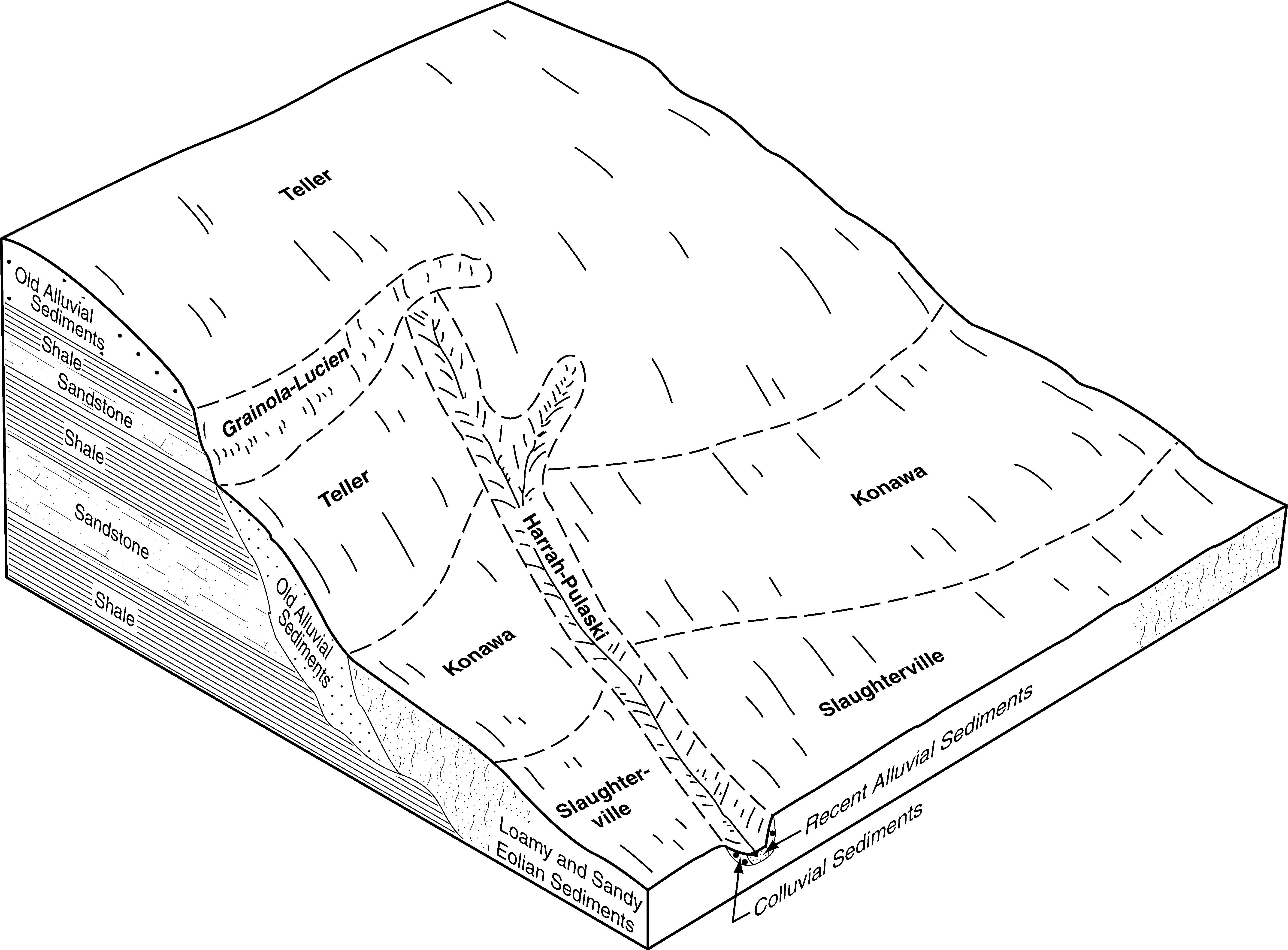
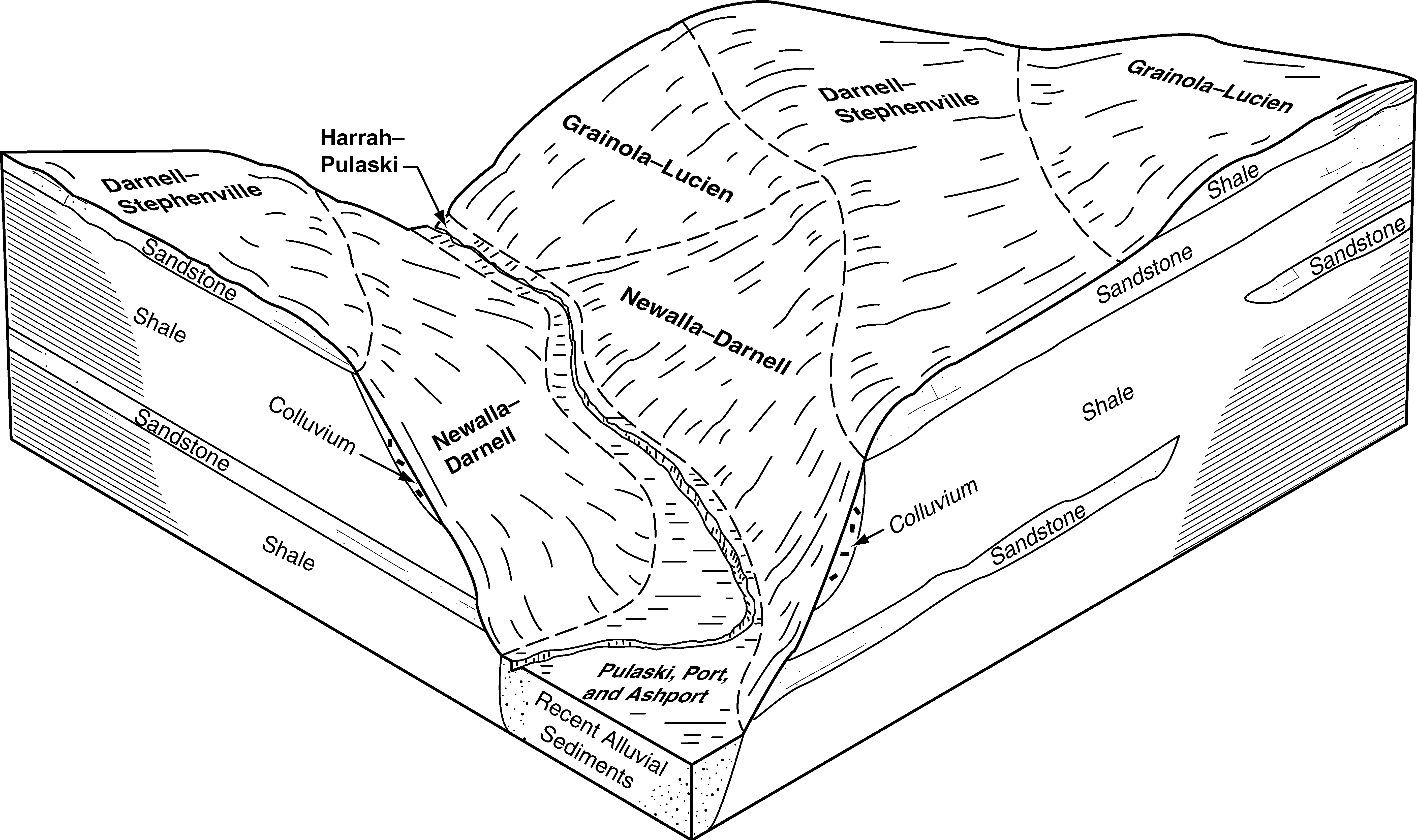
Harrah-Pulaski frequently flooded complex, 0 to 12 percent slopes, very rocky | HaPE | 1742 | 384063 | 2zh6w | ok103 | 1994 | 1:24000 |
Pulaski fine sandy loam, 0 to 1 percent slopes, occasionally flooded | PulA | 1293 | 384104 | 2s7g6 | ok103 | 1994 | 1:24000 |
Pulaski fine sandy loam, 0 to 1 percent slopes, frequently flooded | PukA | 850 | 384103 | 2s7g8 | ok103 | 1994 | 1:24000 |
Pulaski and Tribbey soils, 0 to 1 percent slopes, frequently flooded | PuTA | 7681 | 384197 | dwsg | ok107 | 1996 | 1:24000 |
Pulaski fine sandy loam, 0 to 1 percent slopes, occasionally flooded | PulA | 925 | 384198 | 2s7g6 | ok107 | 1996 | 1:24000 |
Pulaski fine sandy loam, 0 to 1 percent slopes, occasionally flooded | PulA | 7119 | 384347 | 2s7g6 | ok109 | 1996 | 1:12000 |
Pulaski fine sandy loam, 0 to 1 percent slopes, frequently flooded | PukA | 1885 | 384346 | 2s7g8 | ok109 | 1996 | 1:12000 |
Ashport, Port and Pulaski soils, 0 to 1 percent slopes, frequently flooded | APPA | 1 | 1427094 | 2tq7b | ok113 | 1975 | 1:24000 |
Ashport, Port and Pulaski soils, 0 to 1 percent slopes, frequently flooded | APPA | 18379 | 1423149 | 2tq7b | ok117 | 2007 | 1:24000 |
Harrah-Pulaski frequently flooded complex, 0 to 12 percent slopes, very rocky | HaPE | 1323 | 1677344 | 2zh6w | ok117 | 2007 | 1:24000 |
Pulaski fine sandy loam, 0 to 1 percent slopes, occasionally flooded | PulA | 808 | 1677367 | 2s7g6 | ok117 | 2007 | 1:24000 |
Pulaski fine sandy loam, 0 to 1 percent slopes, frequently flooded | 6 | 25181 | 384559 | 2s7g8 | ok119 | 1983 | 1:24000 |
Harrah-Pulaski frequently flooded complex, 0 to 12 percent slopes, very rocky | HaPE | 5561 | 1907387 | 2zh6w | ok119 | 1983 | 1:24000 |
Pulaski fine sandy loam, 0 to 1 percent slopes, occasionally flooded | 43 | 5017 | 384541 | 2s7g6 | ok119 | 1983 | 1:24000 |
Ashport, Port and Pulaski soils, 0 to 1 percent slopes, frequently flooded | APPA | 1639 | 1900485 | 2tq7b | ok119 | 1983 | 1:24000 |
Pulaski fine sandy loam, 0 to 1 percent slopes, occasionally flooded | 35 | 17333 | 384696 | 2s7g6 | ok125 | 1975 | 1:24000 |
Ashport, Port and Pulaski soils, 0 to 1 percent slopes, frequently flooded | 34 | 7080 | 384695 | 2tq7b | ok125 | 1975 | 1:24000 |
Pulaski fine sandy loam, 0 to 1 percent slopes, occasionally flooded | 25 | 6302 | 384811 | 2s7g6 | ok133 | 1976 | 1:24000 |
Stephenville-Pulaski, frequently flooded, complex, 0 to 20 percent slopes | Rs | 30338 | 384882 | dxhk | ok137 | 1960 | 1:24000 |
Pulaski loamy fine sand, 0 to 1 percent slopes, frequently flooded | Sa | 369 | 384883 | dxhl | ok137 | 1960 | 1:24000 |