Official Series Description


Lab Data Summary

Aggregate lab data for the IRONMOUND soil series. This aggregation is based on all pedons with a current taxon name of IRONMOUND, and applied along 1-cm thick depth slices. Solid lines are the slice-wise median, bounded on either side by the interval defined by the slice-wise 5th and 95th percentiles. The median is the value that splits the data in half. Five percent of the data are less than the 5th percentile, and five percent of the data are greater than the 95th percentile. Values along the right hand side y-axis describe the proportion of pedon data that contribute to aggregate values at this depth. For example, a value of "90%" at 25cm means that 90% of the pedons correlated to IRONMOUND were used in the calculation. Source: KSSL snapshot . Methods used to assemble the KSSL snapshot used by SoilWeb / SDE

Click the image to view it full size.

Pedons used in the lab summary:

MLRALab IDPedon IDTaxonnameCINSSL / NASIS ReportsLink To SoilWeb GMap
80A75-OK-75-575-OK015-75-5Ironmound4Primary | Supplementary | Taxonomy | Pedon | Water Retention | Correlation | Andic Soil Properties35.4493528,-98.5497583
80A93P0392S1992OK083005Ironmound5Primary | Supplementary | Taxonomy | Pedon | Water Retention | Correlation | Andic Soil Properties36.0905571,-97.6586075

Water Balance

Monthly water balance estimated using a leaky-bucket style model for the IRONMOUND soil series. Monthly precipitation (PPT) and potential evapotranspiration (PET) have been estimated from the 50th percentile of gridded values (PRISM 1981-2010) overlapping with the extent of SSURGO map units containing each series as a major component. Monthly PET values were estimated using the method of Thornthwaite (1948). These (and other) climatic parameters are calculated with each SSURGO refresh and provided by the fetchOSD function of the soilDB package. Representative water storage values (“AWC” in the figures) were derived from SSURGO by taking the 50th percentile of profile-total water storage (sum[awc_r * horizon thickness]) for each soil series. Note that this representation of “water storage” is based on the average ability of most plants to extract soil water between 15 bar (“permanent wilting point”) and 1/3 bar (“field capacity”) matric potential. Soil moisture state can be roughly interpreted as “dry” when storage is depleted, “moist” when storage is between 0mm and AWC, and “wet” when there is a surplus. Clearly there are a lot of assumptions baked into this kind of monthly water balance. This is still a work in progress.

Click the image to view it full size.


Click the image to view it full size.

Sibling Summary

Siblings are those soil series that occur together in map units, in this case with the IRONMOUND series. Sketches are arranged according to their subgroup-level taxonomic structure. Source: SSURGO snapshot , parsed OSD records and snapshot of SC database .

Click the image to view it full size.

Select annual climate data summaries for the IRONMOUND series and siblings. Series are sorted according to hierarchical clustering of median values. Source: SSURGO map unit geometry and 1981-2010, 800m PRISM data .

Click the image to view it full size.

Geomorphic description summaries for the IRONMOUND series and siblings. Series are sorted according to hierarchical clustering of proportions and relative hydrologic position within an idealized landform (e.g. top to bottom). Most soil series (SSURGO components) are associated with a hillslope position and one or more landform-specific positions: hills, mountain slopes, terraces, and/or flats. Proportions can be interpreted as an aggregate representation of geomorphic membership. The values printed to the left (number of component records) and right (Shannon entropy) of stacked bars can be used to judge the reliability of trends. Small Shannon entropy values suggest relatively consistent geomorphic association, while larger values suggest lack thereof. Source: SSURGO component records .

Click the image to view it full size.

Click the image to view it full size.

There are insufficient data to create the 3D mountains figure.

Click the image to view it full size.

There are insufficient data to create the 3D flats position figure.

Competing Series

Soil series competing with IRONMOUND share the same family level classification in Soil Taxonomy. Source: parsed OSD records and snapshot of the SC database .

Click the image to view it full size.

Select annual climate data summaries for the IRONMOUND series and competing. Series are sorted according to hierarchical clustering of median values. Source: SSURGO map unit geometry and 1981-2010, 800m PRISM data .

There are insufficient data to create the annual climate figure.

Geomorphic description summaries for the IRONMOUND series and competing. Series are sorted according to hierarchical clustering of proportions and relative hydrologic position within an idealized landform (e.g. top to bottom). Proportions can be interpreted as an aggregate representation of geomorphic membership. Most soil series (SSURGO components) are associated with a hillslope position and one or more landform-specific positions: hills, mountain slopes, terraces, and/or flats. The values printed to the left (number of component records) and right (Shannon entropy) of stacked bars can be used to judge the reliability of trends. Shannon entropy values close to 0 represent soil series with relatively consistent geomorphic association, while values close to 1 suggest lack thereof. Source: SSURGO component records .

There are insufficient data to create the 2D hillslope position figure.

There are insufficient data to create the 3D hills figure.

There are insufficient data to create the 3D mountains figure.

There are insufficient data to create the 3D terrace figure.

There are insufficient data to create the 3D flats position figure.

Soil series sharing subgroup-level classification with IRONMOUND, arranged according to family differentiae. Hovering over a series name will print full classification and a small sketch from the OSD. Source: snapshot of SC database .

Block Diagrams

Click a link below to display the diagram. Note that these diagrams may be from multiple survey areas.

  1. OK-2010-09-29-01 | Logan County - 2006

    Typical pattern of soils and underlying material in the Grainola-Masham-Ironmound general soil map unit (Soil Survey of Logan County, Oklahoma; 2006).

  2. OK-2010-09-29-02 | Logan County - 2006

    Typical pattern of soils and underlying material in the Ashport-Pulaski-Lawrie general soil map unit (Soil Survey of Logan County, Oklahoma; 2006).

  3. OK-2010-09-29-03 | Logan County - 2006

    Typical pattern of soils and underlying material in the Grainola-Renfrow-Piedmont general soil map unit (Soil Survey of Logan County, Oklahoma; 2006).

  4. OK-2010-09-29-05 | Logan County - 2006

    Typical pattern of soils and underlying material in the Stephenville-Darsil-Harrah general soil map unit (Soil Survey of Logan County, Oklahoma; 2006).

  5. OK-2010-09-29-06 | Logan County - 2006

    Typical pattern of soils and underlying material in the Coyle-Ironmound-Zaneis general soil map unit (Soil Survey of Logan County, Oklahoma; 2006).

  6. OK-2010-09-29-15 | Oklahoma County - 2004

    Typical pattern of soils and underlying material in the Renfrow-Grainola-Piedmont general soil map unit (Soil Survey of Oklahoma County, Oklahoma; 2004).

  7. OK-2010-09-29-17 | Oklahoma County - 2004

    Typical pattern of soils and underlying material in the Ashport-Miller general soil map unit (Soil Survey of Oklahoma County, Oklahoma; 2004).

Map Units

Map units containing IRONMOUND as a major component. Limited to 250 records.

Map Unit Name Symbol Map Unit Area (ac) Map Unit Key National Map Unit Symbol Soil Survey Area Publication Date Map Scale
Ironmound-Nash complex, 3 to 12 percent slopesIrNE1248622474nwqtok00319711:24000
Ironmound loam, 1 to 3 percent slopesIroB363622532nwspok00319711:24000
Ironmound loam, 3 to 5 percent slopes, erodedIroC2957750002tq5nok00319711:24000
Kingfisher-Ironmound complex, 5 to 8 percent slopes, shallow, erodedKgID230622376nwmnok00319711:24000
Ironmound-Dill complex, 3 to 12 percent slopesLuD33659381897dtd8ok01519671:24000
Ironmound-Nash complex, 5 to 12 percent slopesQwD23832381916dtdwok01519671:24000
Ironmound-Dill complex, 12 to 30 percent slopesLuE3624381898dtd9ok01519671:24000
Nash-Ironmound complex, 3 to 8 percent slopesNaD12683381962dtgcok01719721:24000
Grant-Ironmound complex, 5 to 8 percent slopesGuD6017381949dtfyok01719721:24000
Nash-Ironmound complex, 3 to 8 percent slopes, erodedNaD25730381963dtgdok01719721:24000
Dill-Ironmound complex, 5 to 8 percent slopesDuD5267381939dtfmok01719721:24000
Ironmound-Rock outcrop complex, 12 to 30 percent slopesQrF5040381974dtgrok01719721:24000
Ironmound-Dill complex, 5 to 12 percent slopesQdE2924381973dtgqok01719721:24000
Grant-Ironmound complex, 3 to 8 percent slopes, erodedGuD22400381950dtfzok01719721:24000
Nash-Ironmound complex, 3 to 8 percent slopes, severely erodedNaD31230381964dtgfok01719721:24000
Kingfisher-Ironmound complex, 1 to 5 percent slopes970753821532tq6cok02719841:24000
Grainola-Ironmound complex, 5 to 12 percent slopes65240382122dtmjok02719841:24000
Ironmound very fine sandy loam, 5 to 8 percent slopes29599382096dtlpok02719841:24000
Kingfisher-Urban land-Ironmound complex, 1 to 5 percent slopes281393820952tq6gok02719841:24000
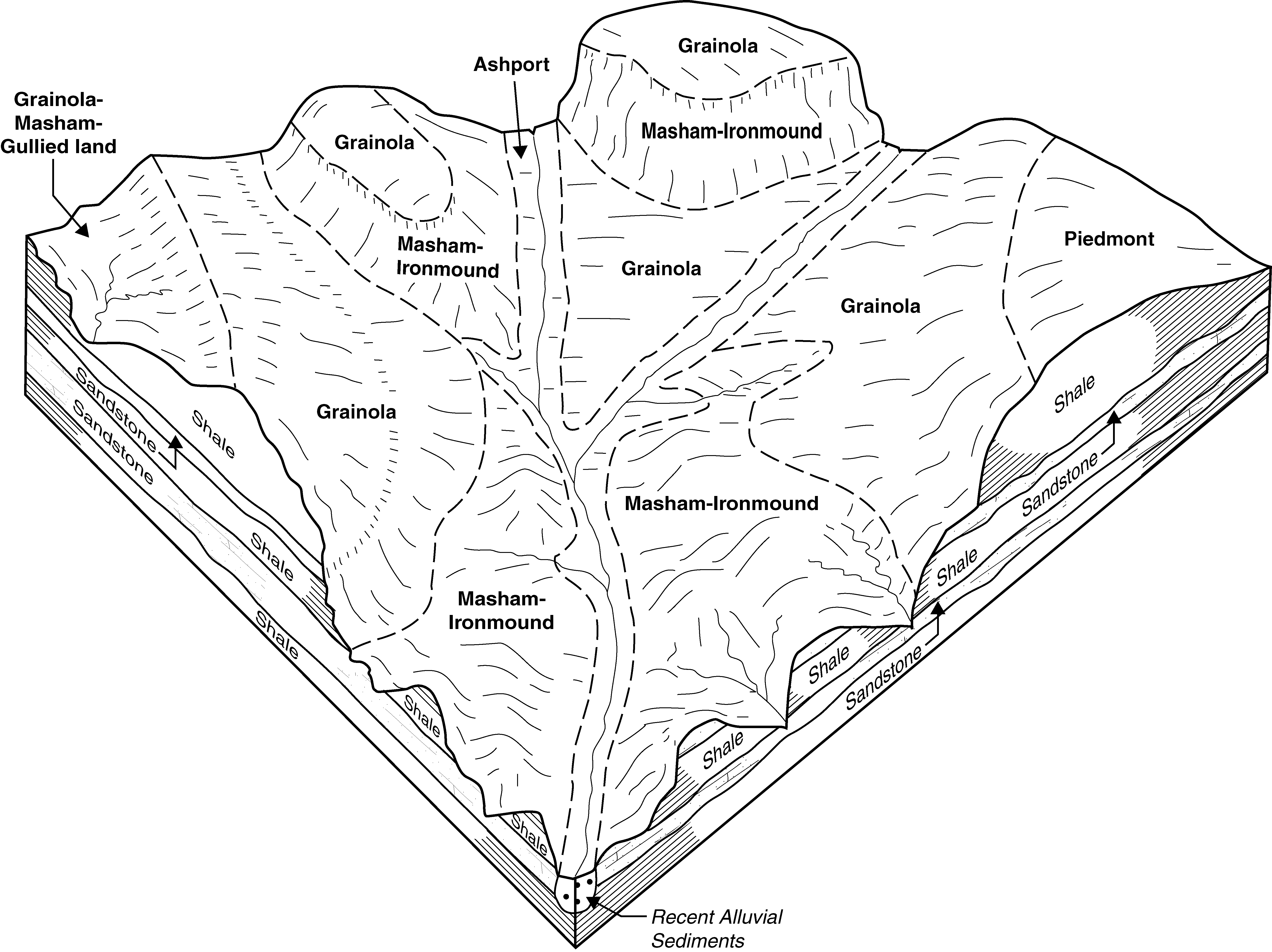
Grainola-Masham-Ironmound complex, 5 to 12 percent slopesVrD38392382533dv1sok04719651:24000
Kingfisher-Ironmound complex, 5 to 8 percent slopes, shallow, erodedGnD29974382494dv0jok04719651:24000
Kingfisher-Ironmound complex, 8 to 20 percent slopes, erodedGnE27568382496dv0lok04719651:24000
Kingfisher-Ironmound complex, 8 to 20 percent slopesGnE7419382495dv0kok04719651:24000
Kingfisher-Ironmound complex, 5 to 8 percent slopesGnD2701382493dv0hok04719651:24000
Ironmound very fine sandy loam, 3 to 5 percent slopesLuC814382503dv0tok04719651:24000
Kingfisher-Ironmound complex, 5 to 8 percent slopes, erodedKlD2244382499dv0pok04719651:24000
Ironmound-Nash complex, 5 to 12 percent slopes478394382580dv39ok04919821:24000
Ironmound stony loam, 12 to 30 percent slopes465732382579dv38ok04919821:24000
Ironmound-Rock outcrop complex, 12 to 30 percent slopes427629382663dv5zok05119751:24000
Ironmound-Nash complex, 3 to 12 percent slopes465635382736dv8bok05319831:24000
Ironmound loam, 1 to 3 percent slopes443398382734dv88ok05319831:24000
Ironmound loam, 3 to 5 percent slopes, eroded4531373827352tq5nok05319831:24000
Grainola-Ironmound complex, 5 to 15 percent slopesVlE34919383544dw3dok08119661:24000
Coyle-Ironmound complex, 3 to 5 percent slopes, erodedCoIC2278513835992wrk6ok08319941:12000
Ironmound-Coyle complex, 5 to 15 percent slopesIrCE193063836312tq5pok08319941:12000
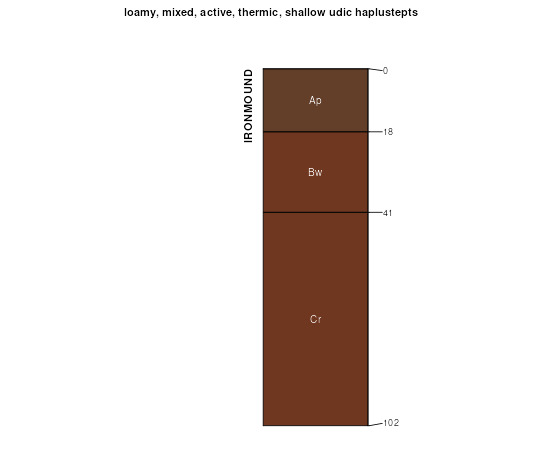
Masham-Ironmound complex, 5 to 15 percent slopesMaID14389383645dw6nok08319941:12000
Coyle-Ashport frequently flooded-Ironmound complex, 1 to 8 percent slopesCAID6262383597dw53ok08319941:12000
Ironmound-Coyle-Grainola complex, 5 to 8 percent slopes, severely erodedICGD33456383630dw65ok08319941:12000
Masham-Ironmound complex, 15 to 40 percent slopesMaIG1514383646dw6pok08319941:12000
Ironmound loam, 3 to 5 percent slopes, erodedIroC28783836322tq5nok08319941:12000
Grainola-Ironmound complex, 3 to 12 percent slopesGrIE6215874771q8wyok08319941:12000
Kingfisher-Ironmound complex, 5 to 8 percent slopes, shallow, erodedKgID25013835691hfq8ok09319651:24000
Grainola-Ironmound complex, 3 to 12 percent slopesGrIE6478384297dwwpok10919961:12000
Grainola-Urban land-Ironmound complex, 3 to 12 percent slopesGUIE4046384291dwwhok10919961:12000
Ironmound-Coyle complex, 5 to 15 percent slopesIrCE11863843072tq5pok10919961:12000
Kingfisher-Ironmound complex, 1 to 5 percent slopesKgIC10803843132tq6cok10919961:12000
Coyle-Ironmound complex, 3 to 5 percent slopes, erodedCoIC26043842772wrk6ok10919961:12000
Ironmound-Kingfisher complex, 1 to 8 percent slopesIrKD544384308dwx1ok10919961:12000
Kingfisher-Urban land-Ironmound complex, 1 to 5 percent slopesKUIC4123843092tq6gok10919961:12000

Map of Series Extent

Approximate geographic distribution of the IRONMOUND soil series. To learn more about how this distribution was mapped, or to compare this soil series extent to others, use the Series Extent Explorer (SEE) application. Source: generalization of SSURGO geometry .