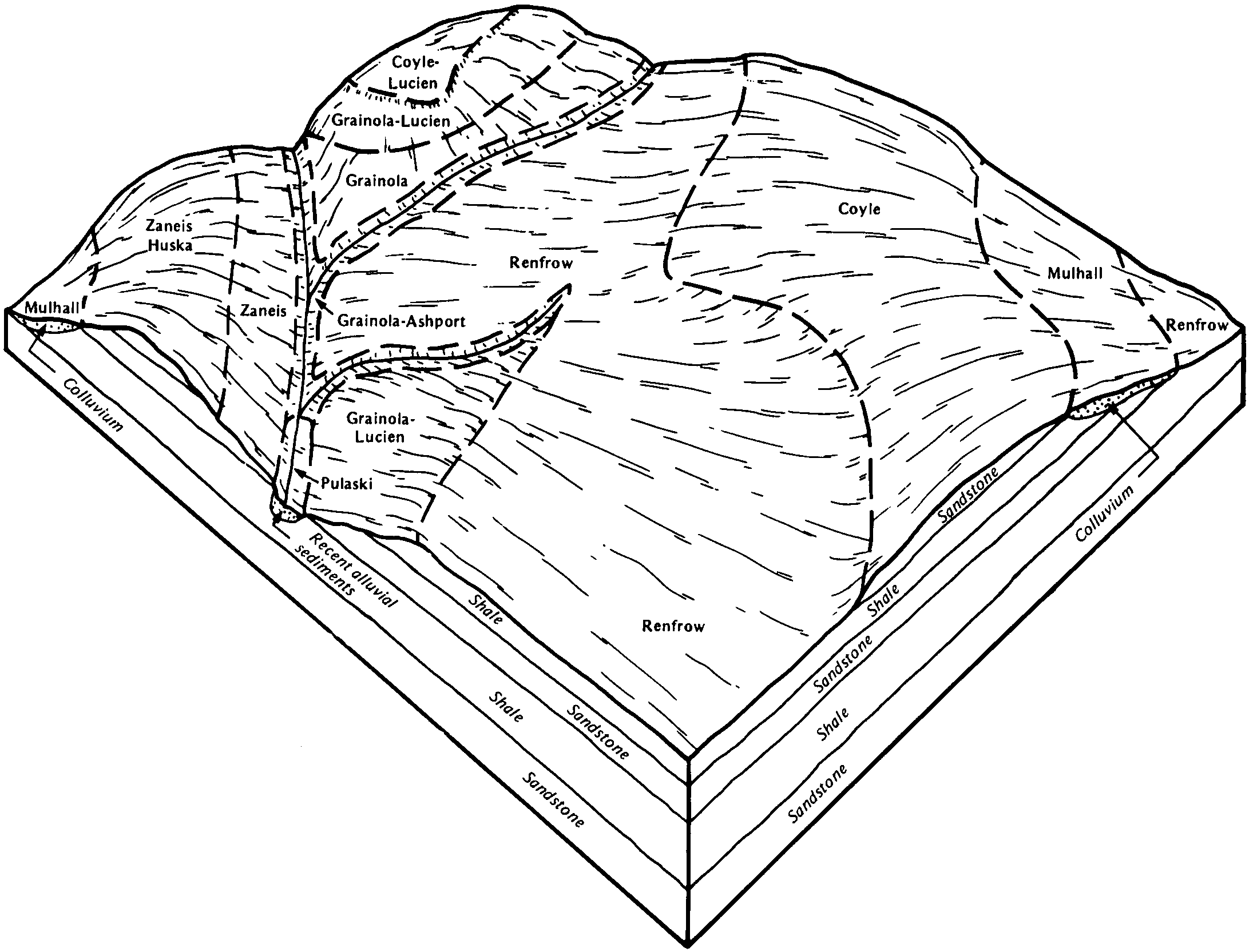
| Grainola, Ashport frequently flooded, and Grant soils, 0 to 20 percent slopes | GAGF | 56 | 622379 | nwmr | ok003 | 1971 | 1:24000 |
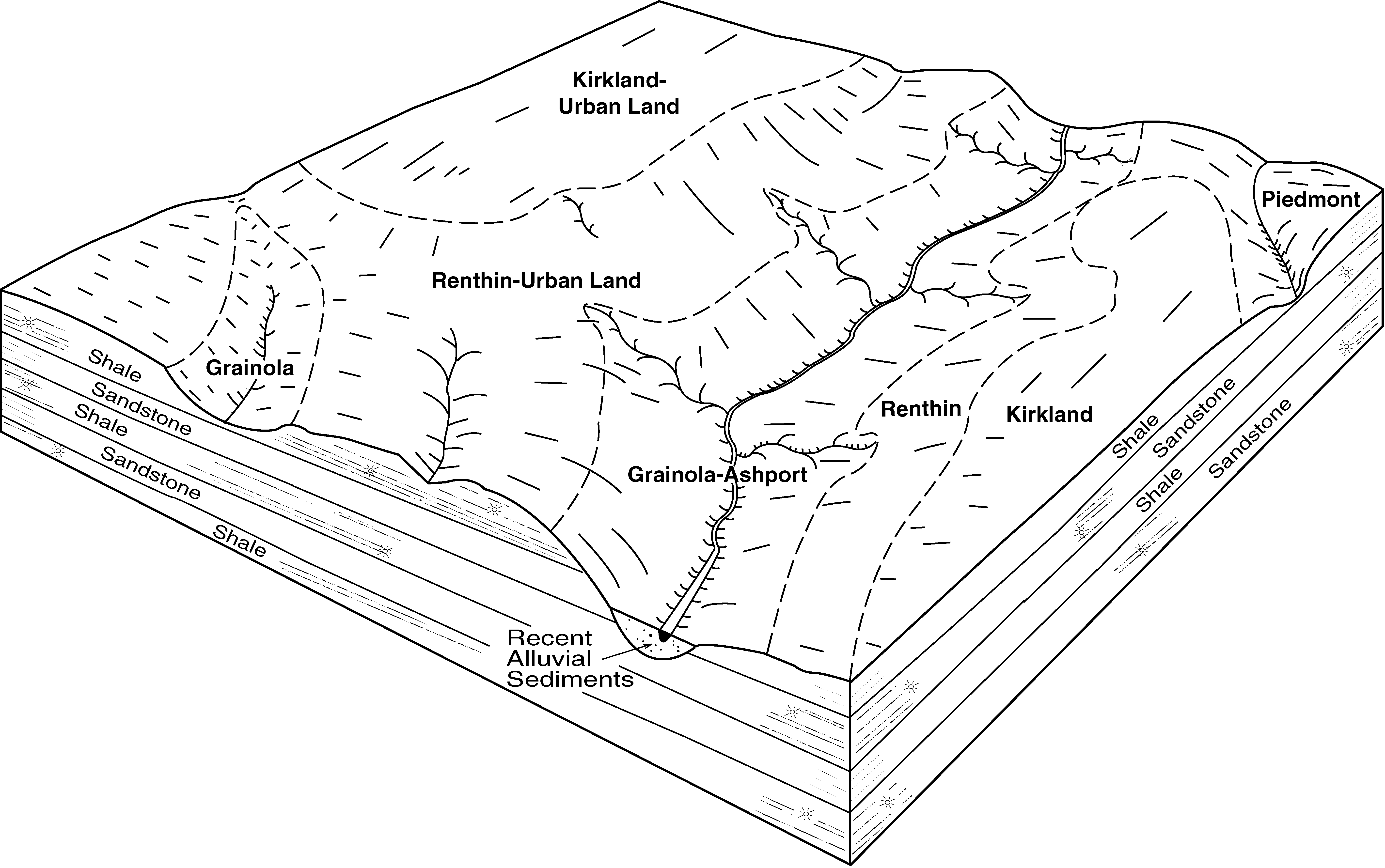
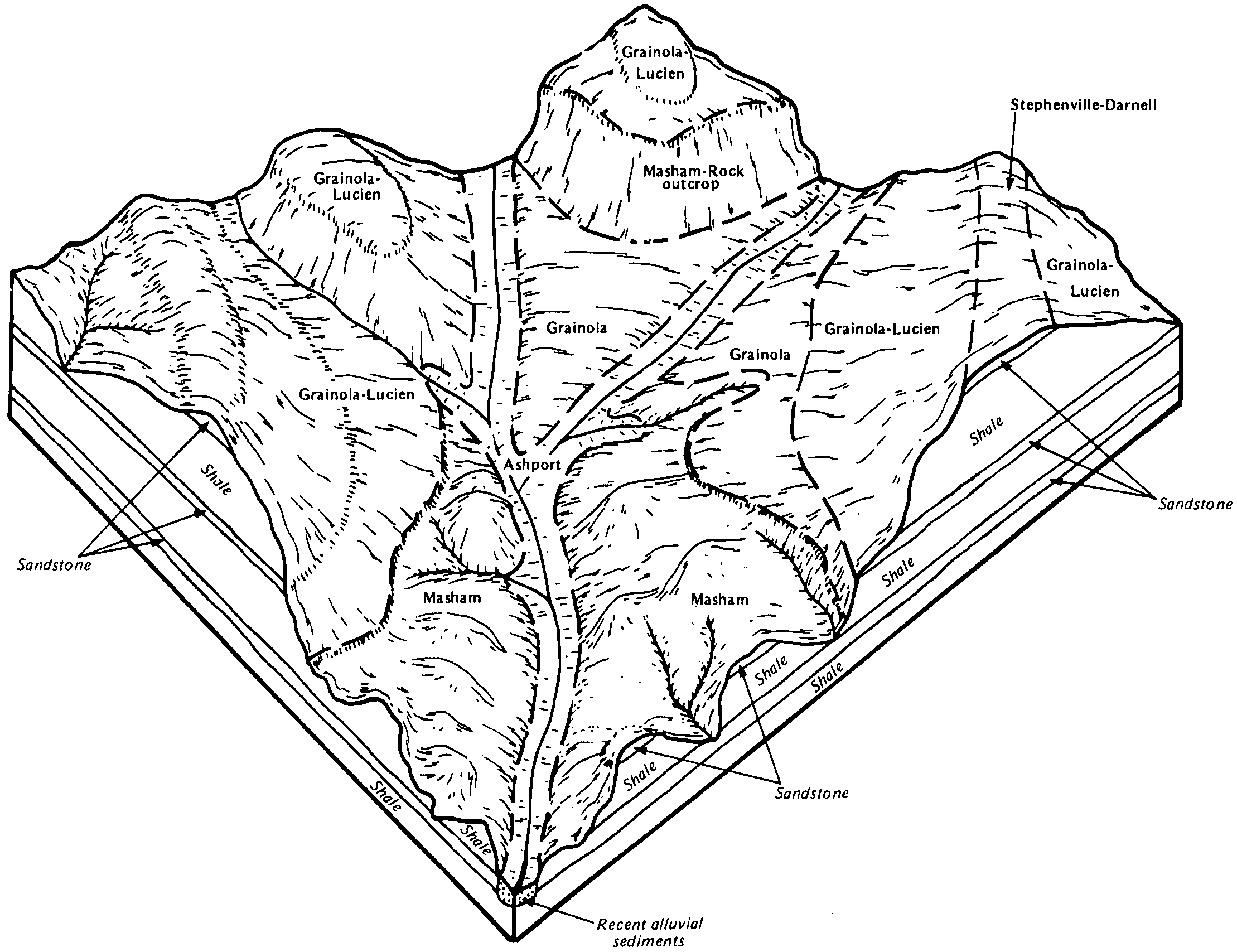
Grainola-Ashport, frequently flooded, complex, 0 to 12 percent slopes | 3 | 6873 | 382097 | 2tq76 | ok027 | 1984 | 1:24000 |
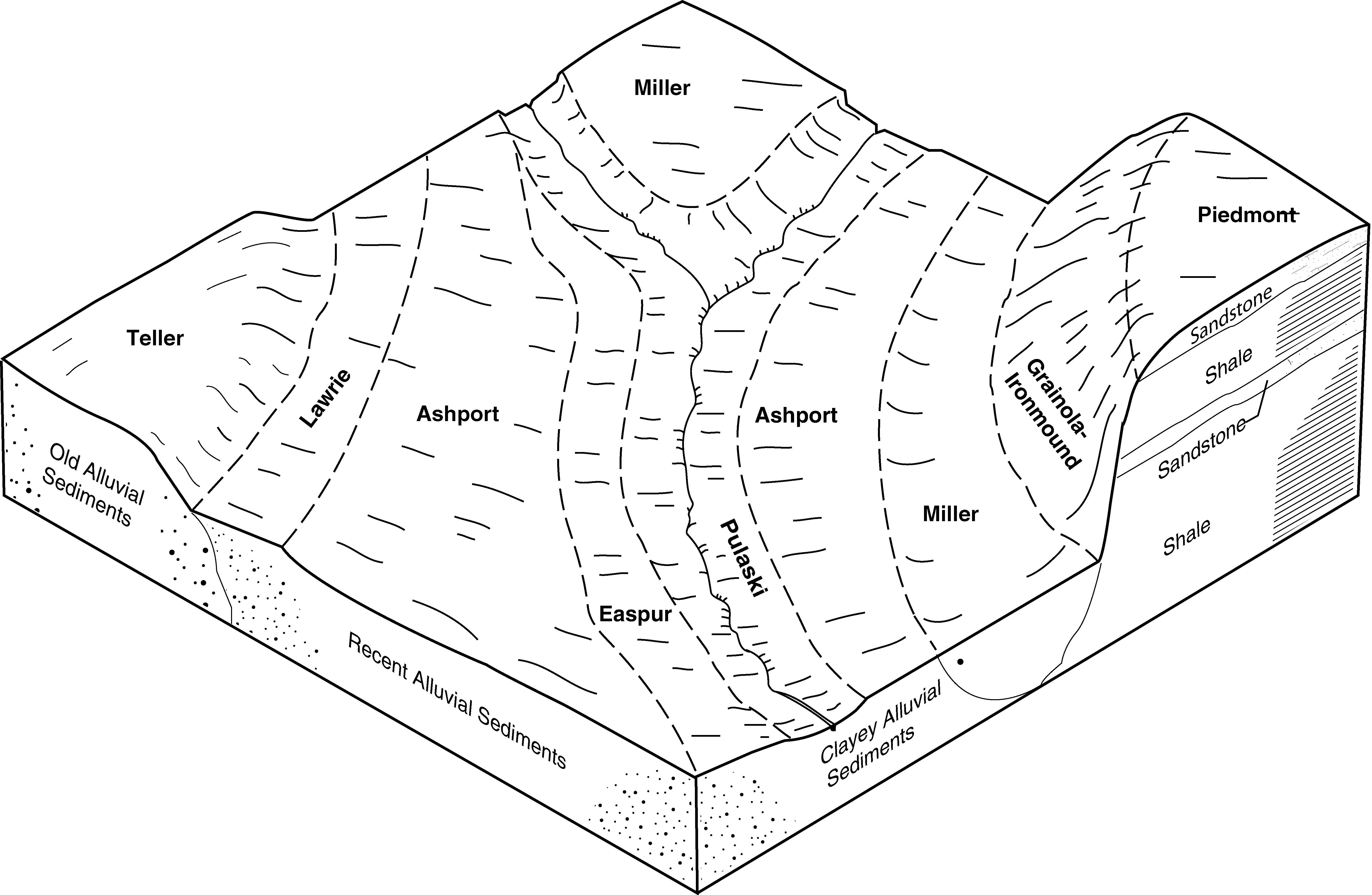
Ashport silt loam, 0 to 1 percent slopes, occasionally flooded | 96 | 5541 | 382160 | 2tq74 | ok027 | 1984 | 1:24000 |
Norge-Ashport silt loams complex, 0 to 8 percent slopes, frequently flooded | 33 | 4763 | 382100 | 30g73 | ok027 | 1984 | 1:24000 |
Ashport silt loam, 0 to 1 percent slopes, frequently flooded | AstA | 81 | 752390 | 2tq75 | ok027 | 1984 | 1:24000 |
Ashport loam, 0 to 1 percent slopes, occasionally flooded | Po | 31836 | 382196 | 2tq77 | ok031 | 1965 | 1:24000 |
Ashport clay loam, 0 to 1 percent slopes, occasionally flooded | Pc | 30816 | 382195 | 2tq71 | ok031 | 1965 | 1:24000 |
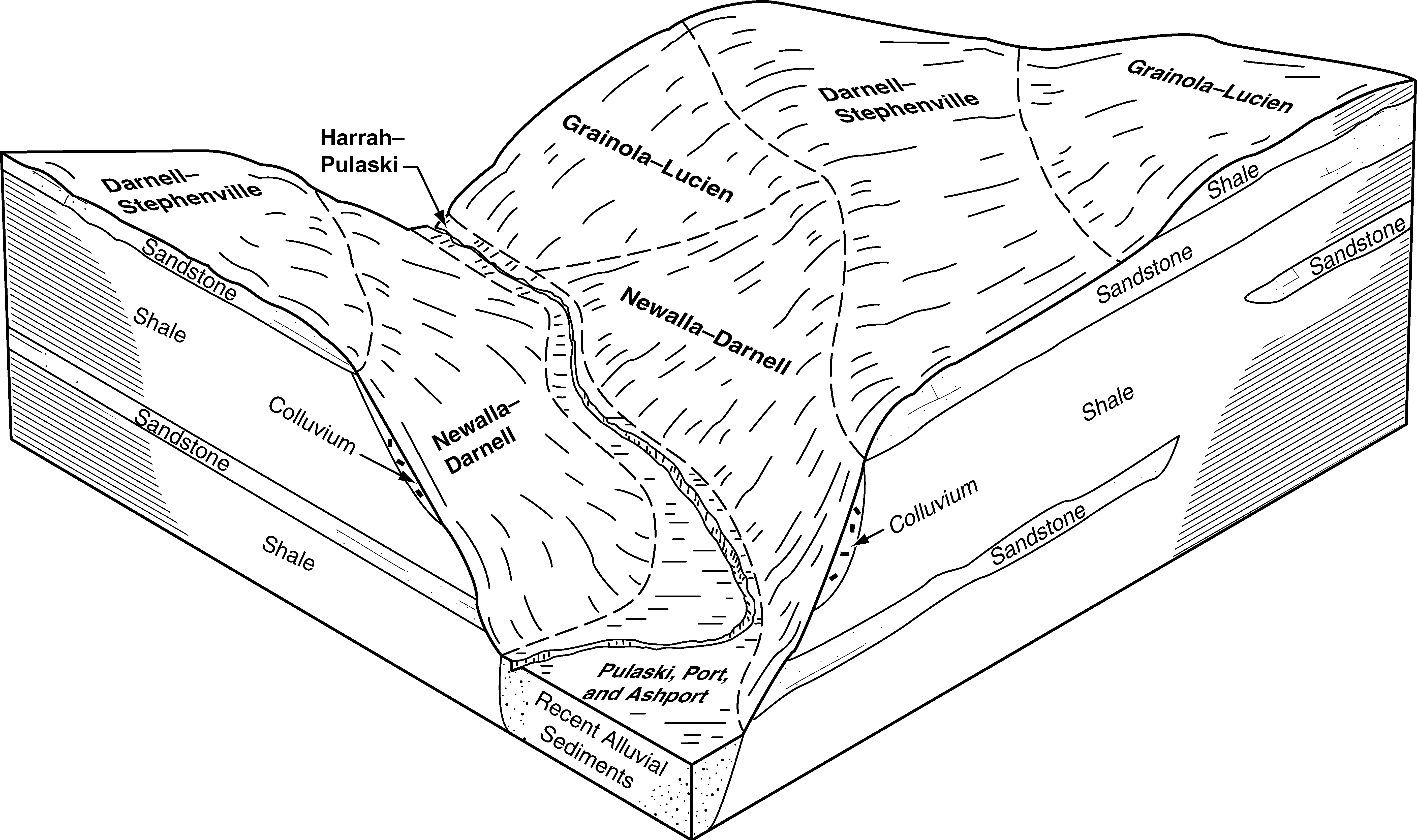
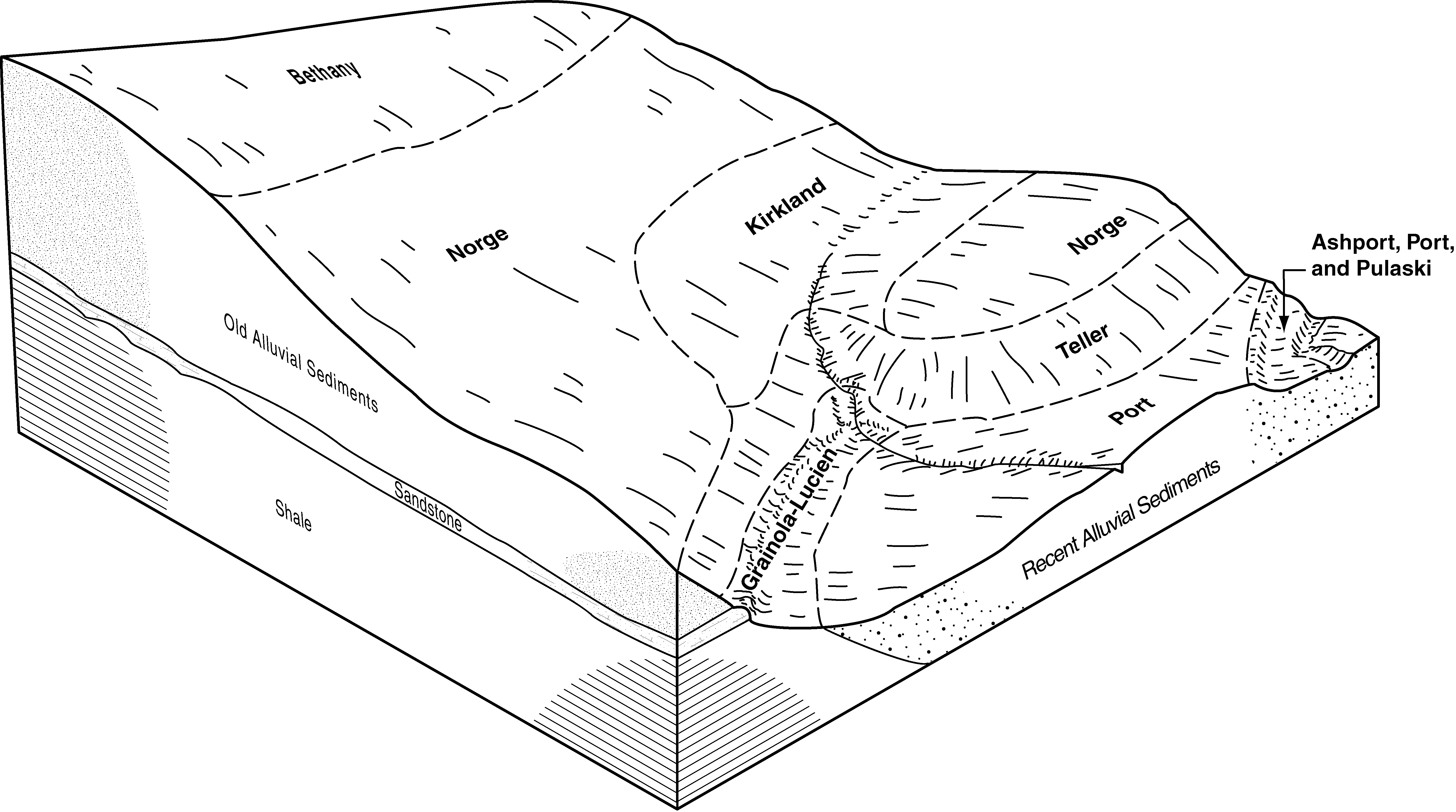
Ashport, Port and Yahola soils, 0 to 1 percent slopes, frequently flooded | Br | 12502 | 382166 | 2yh68 | ok031 | 1965 | 1:24000 |
Ashport-Oscar complex, 0 to 1 percent slopes, occasionally flooded | Ps | 10361 | 382197 | 2yh69 | ok031 | 1965 | 1:24000 |
Ashport silt loam, 0 to 1 percent slopes, frequently flooded | Ga | 22212 | 382286 | 2tq75 | ok037 | 1952 | 1:24000 |
Ashport, Port and Pulaski soils, 0 to 1 percent slopes, frequently flooded | APPA | 304 | 2516362 | 2tq7b | ok037 | 1952 | 1:24000 |
Grainola, Ashport frequently flooded, and Grant soils, 0 to 20 percent slopes | Bk | 32237 | 382484 | dv06 | ok047 | 1965 | 1:24000 |
Pulaski and Ashport soils, 0 to 1 percent slopes, frequently flooded | Br | 19601 | 382485 | 30g74 | ok047 | 1965 | 1:24000 |
Ashport silty clay loam, 0 to 1 percent slopes, occasionally flooded | 2 | 1069 | 382550 | 2tq73 | ok049 | 1982 | 1:24000 |
Masham-Ashport frequently flooded complex, 0 to 20 percent slopes | 33 | 10521 | 382722 | dv7w | ok053 | 1983 | 1:24000 |
Ashport silt loam, 0 to 1 percent slopes, occasionally flooded | AspA | 16 | 601438 | 2tq74 | ok053 | 1983 | 1:24000 |
Grainola-Ashport, frequently flooded, complex, 0 to 12 percent slopes | Bk | 3059 | 383218 | 2tq76 | ok067 | 1967 | 1:24000 |
Grainola-Ashport, frequently flooded, complex, 0 to 12 percent slopes | Bk | 12392 | 383319 | 2tq76 | ok071 | 1965 | 1:24000 |
Ashport silt loam, 0 to 1 percent slopes, occasionally flooded | Ps | 9245 | 383358 | 2tq74 | ok071 | 1965 | 1:24000 |
Ashport, Port and Pulaski soils, 0 to 1 percent slopes, frequently flooded | Br | 8631 | 383321 | 2tq7b | ok071 | 1965 | 1:24000 |
Ashport silt loam, 0 to 1 percent slopes, frequently flooded | Pf | 2772 | 383357 | 2tq75 | ok071 | 1965 | 1:24000 |
Grainola-Ashport, frequently flooded, complex, 0 to 12 percent slopes | Ab | 34650 | 383384 | 2tq76 | ok073 | 1960 | 1:24000 |
Ashport clay loam, 0 to 1 percent slopes, occasionally flooded | PoA | 21300 | 383409 | 2tq71 | ok073 | 1960 | 1:24000 |
Ashport, Port and Pulaski soils, 0 to 1 percent slopes, frequently flooded | Br | 10328 | 383386 | 2tq7b | ok073 | 1960 | 1:24000 |
Grainola-Ashport, frequently flooded, complex, 0 to 12 percent slopes | Bk | 19864 | 383497 | 2tq76 | ok081 | 1966 | 1:24000 |
Ashport clay loam, 0 to 1 percent slopes, occasionally flooded | Pc | 10189 | 383523 | 2tq71 | ok081 | 1966 | 1:24000 |
Ashport, Port and Pulaski soils, 0 to 1 percent slopes, frequently flooded | Br | 8385 | 383501 | 2tq7b | ok081 | 1966 | 1:24000 |
Ashport silt loam, 0 to 1 percent slopes, frequently flooded | AstA | 17871 | 383592 | 2tq75 | ok083 | 1994 | 1:12000 |
Ashport silt loam, 0 to 1 percent slopes, occasionally flooded | AspA | 7785 | 383591 | 2tq74 | ok083 | 1994 | 1:12000 |
Coyle-Ashport frequently flooded-Ironmound complex, 1 to 8 percent slopes | CAID | 6262 | 383597 | dw53 | ok083 | 1994 | 1:12000 |
Ashport clay loam, 0 to 1 percent slopes, occasionally flooded | Nc | 1722 | 383729 | 2tq71 | ok085 | 1963 | 1:24000 |
Ashport, Port and Pulaski soils, 0 to 1 percent slopes, frequently flooded | 39 | 6631 | 383796 | 2tq7b | ok087 | 1976 | 1:24000 |
Ashport loam, 0 to 1 percent slopes, occasionally flooded | 1 | 4195 | 383764 | 2tq77 | ok087 | 1976 | 1:24000 |
Ashport, Port and Pulaski soils, 0 to 1 percent slopes, frequently flooded | APPA | 28954 | 384030 | 2tq7b | ok103 | 1994 | 1:24000 |
Grainola-Ashport frequently flooded-Mulhall complex, 0 to 8 percent slopes | GAMD | 21143 | 1907375 | 2zh6v | ok103 | 1994 | 1:24000 |
Ashport silt loam, 0 to 1 percent slopes, occasionally flooded | AspA | 7040 | 384032 | 2tq74 | ok103 | 1994 | 1:24000 |
Ashport silty clay loam, 0 to 1 percent slopes, occasionally flooded | AhpA | 4026 | 384031 | 2tq73 | ok103 | 1994 | 1:24000 |
Ashport silt loam, 1 to 3 percent slopes, occasionally flooded | AspB | 504 | 384033 | 2yh67 | ok103 | 1994 | 1:24000 |
Ashport silt loam, 0 to 1 percent slopes, frequently flooded | AstA | 8489 | 384271 | 2tq75 | ok109 | 1996 | 1:12000 |
Grainola-Ashport, frequently flooded, complex, 0 to 12 percent slopes | GrAD | 6853 | 384295 | 2tq76 | ok109 | 1996 | 1:12000 |
Ashport silt loam, 0 to 1 percent slopes, occasionally flooded | AspA | 3473 | 384270 | 2tq74 | ok109 | 1996 | 1:12000 |
Ashport silty clay loam, 0 to 1 percent slopes, occasionally flooded | AhpA | 1734 | 384267 | 2tq73 | ok109 | 1996 | 1:12000 |
Agra-Ashport, frequently flooded complex, 0 to 12 percent slopes | 18 | 26995 | 623413 | 2y2sc | ok113 | 1975 | 1:24000 |
Ashport, Port and Pulaski soils, 0 to 1 percent slopes, frequently flooded | APPA | 1 | 1427094 | 2tq7b | ok113 | 1975 | 1:24000 |
Ashport, Port and Pulaski soils, 0 to 1 percent slopes, frequently flooded | APPA | 18379 | 1423149 | 2tq7b | ok117 | 2007 | 1:24000 |
Grainola-Ashport frequently flooded-Mulhall complex, 0 to 8 percent slopes | GAMD | 11104 | 1675948 | 2zh6v | ok117 | 2007 | 1:24000 |
Ashport silt loam, 0 to 1 percent slopes, occasionally flooded | AspA | 1984 | 1677023 | 2tq74 | ok117 | 2007 | 1:24000 |
Ashport silty clay loam, 0 to 1 percent slopes, occasionally flooded | AhpA | 93 | 1883787 | 2tq73 | ok117 | 2007 | 1:24000 |
Grainola-Ashport frequently flooded-Mulhall complex, 0 to 8 percent slopes | GAMD | 13234 | 384538 | 2zh6v | ok119 | 1983 | 1:24000 |
Ashport silty clay loam, 0 to 1 percent slopes, occasionally flooded | 42 | 3257 | 384540 | 2tq73 | ok119 | 1983 | 1:24000 |
Ashport, Port and Pulaski soils, 0 to 1 percent slopes, frequently flooded | APPA | 1639 | 1900485 | 2tq7b | ok119 | 1983 | 1:24000 |
Ashport silt loam, 0 to 1 percent slopes, frequently flooded | AstA | 15 | 623491 | 2tq75 | ok119 | 1983 | 1:24000 |
Grainola-Ashport, frequently flooded, complex, 0 to 12 percent slopes | 50 | 20891 | 384713 | 2tq76 | ok125 | 1975 | 1:24000 |
Ashport, Port and Pulaski soils, 0 to 1 percent slopes, frequently flooded | 34 | 7080 | 384695 | 2tq7b | ok125 | 1975 | 1:24000 |
Zaneis-Ashport frequently flooded complex, 0 to 12 percent slopes | Ba | 24234 | 384846 | dxgd | ok137 | 1960 | 1:24000 |