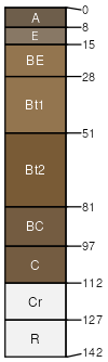
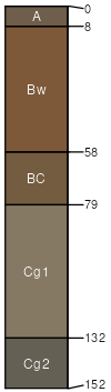
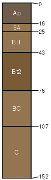
Westmoreland-Guernsey silt loams, 25 to 40 percent slopes, eroded

Westmoreland (45%)
Acid Mixed Sedimentary Upland
Ultic Hapludalfs
Well drained
Hydric: No
PAWS: 20 cm
hills / Backslope
Guernsey (35%)
Acid Mixed Sedimentary Toeslope
Aquic Hapludalfs
Moderately well drained
Hydric: No
PAWS: 20 cm
hills / Backslope
Omulga (3%)


Hydric:
PAWS: NA
terraces
Rigley (3%)


Hydric:
PAWS: NA
hills
Lobdell (3%)


Hydric:
PAWS: NA
flood plains
Newark (3%)


Hydric:
PAWS: NA
flood plains
Berks (3%)


Hydric:
PAWS: NA
hills
Clarksburg (3%)


Hydric:
PAWS: NA
hills
Glenford (2%)


Hydric:
PAWS: NA
lake plains
SSAScalePublishedExport
oh1271:16,00019842023-09-11