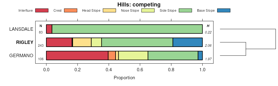
| Rigley-Rock outcrop association, steep | RSF | 5145 | 550257 | lgl7 | ky043 | 1980 | 1:20000 |
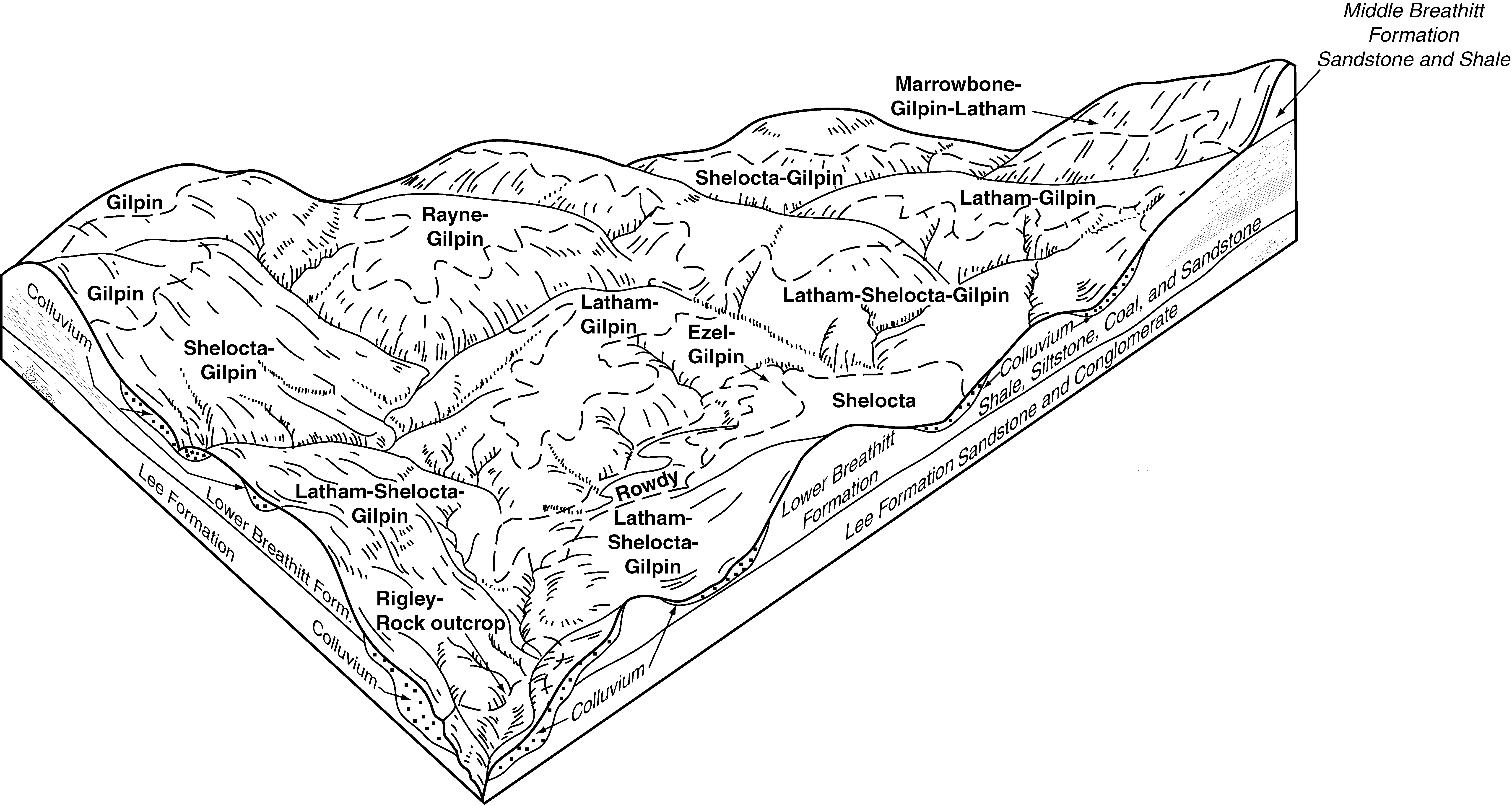
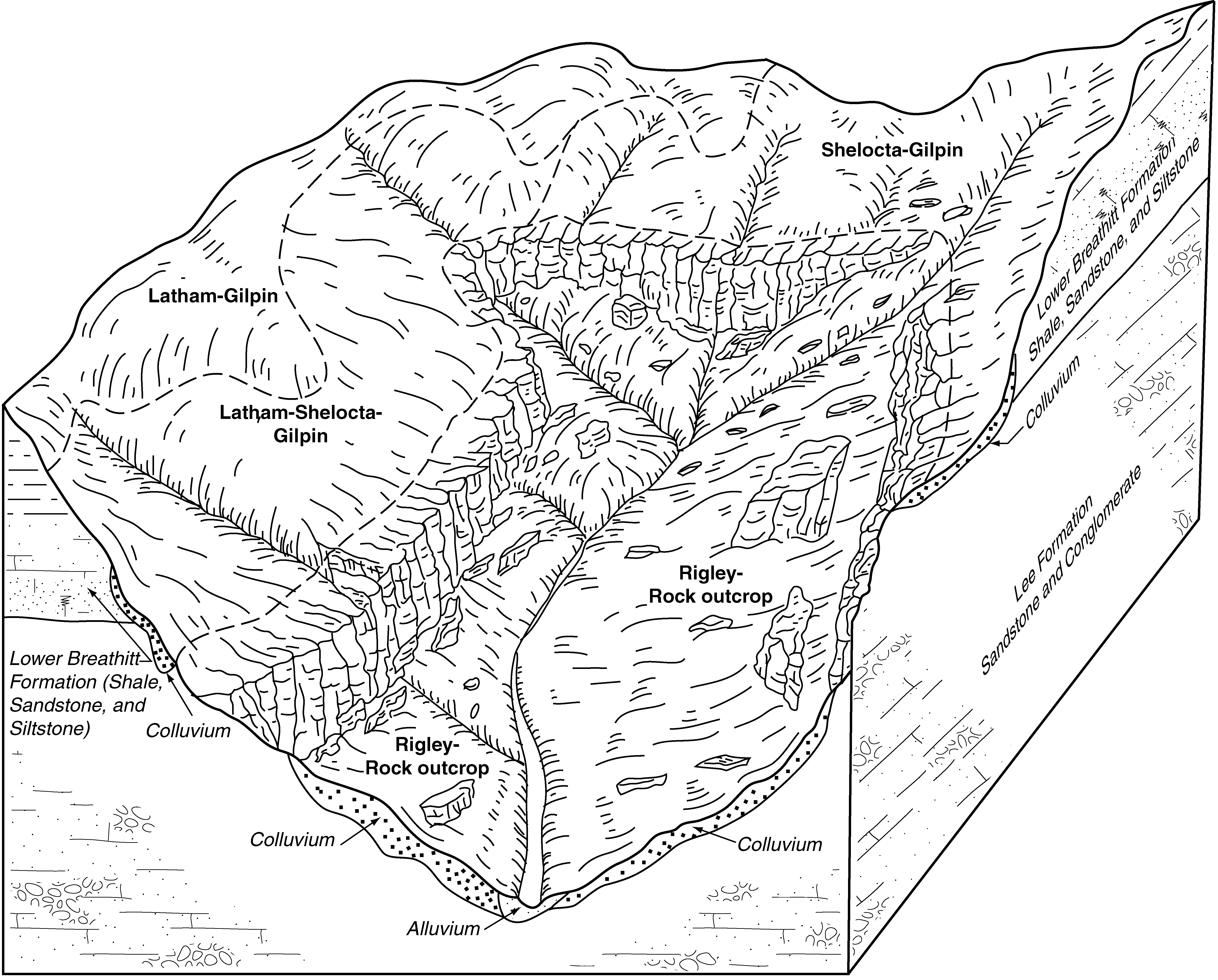
Rigley-Rock outcrop complex, 30 to 70 percent slopes | RgF | 6728 | 1884669 | 2184s | ky063 | 2007 | 1:12000 |
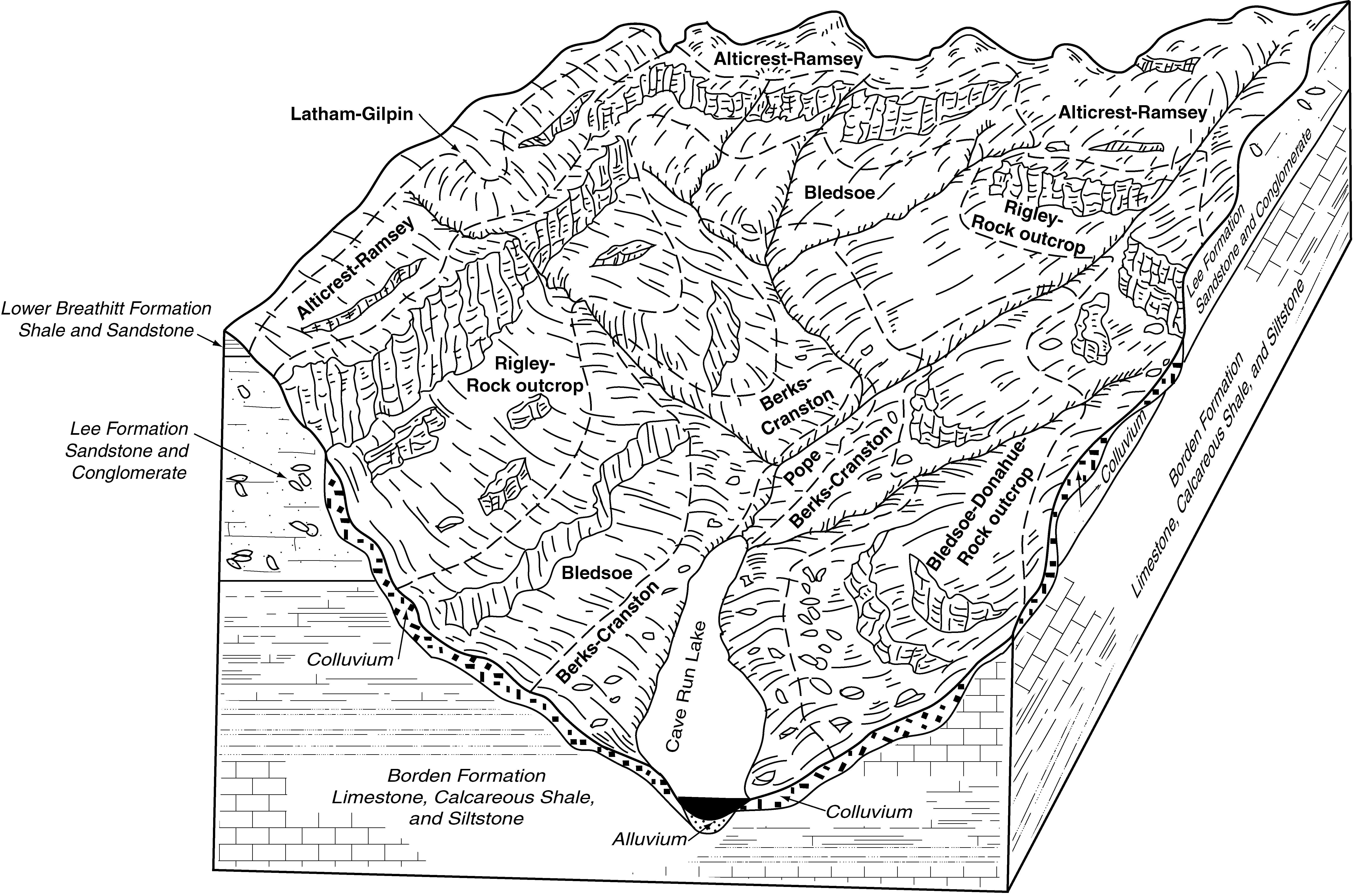
Rigley-Shelocta-Alticrest complex, 20 to 80 percent slopes, stony, very rocky | uRshF | 18419 | 2997076 | 2qyt0 | ky199 | 1969 | 1:12000 |
Shelocta-Highsplint-Rigley complex, 30 to 50 percent slopes, stony, rocky | uShrF | 11188 | 2997079 | 2qytd | ky199 | 1969 | 1:12000 |
Rigley-Shelocta-Muse complex, steep | RMF | 47145 | 550083 | lgdm | ky231 | 1985 | 1:20000 |
Rigley-Rock outcrop association, steep | RCF | 17397 | 550712 | lh1x | ky623 | 1985 | 1:20000 |
Shelocta-Highsplint-Rigley complex, 30 to 50 percent slopes, stony, rocky | uShrF | 52905 | 2997080 | 2qytd | ky628 | 1973 | 1:20000 |
Rigley-Shelocta-Alticrest complex, 20 to 80 percent slopes, stony, very rocky | uRshF | 19761 | 2997077 | 2qyt0 | ky628 | 1973 | 1:20000 |
Shelocta-Rigley complex, 20 to 30 percent slopes | SgE | 8677 | 552295 | ljpz | ky628 | 1973 | 1:20000 |
Rigley stony fine sandy loam, 30 to 60 percent slopes | RgF | 6452 | 552287 | ljpq | ky628 | 1973 | 1:20000 |
Shelocta-Highsplint-Rigley complex, 30 to 50 percent slopes, stony, rocky | uShrF | 32144 | 2997081 | 2qytd | ky630 | 1966 | 1:15840 |
Rigley-Shelocta-Alticrest complex, 20 to 80 percent slopes, stony, very rocky | uRshF | 24040 | 2997078 | 2qyt0 | ky630 | 1966 | 1:15840 |
Lily-Gilpin-Rigley complex, 15 to 35 percent slopes | LyE | 1593 | 550844 | lh65 | ky634 | 1989 | 1:20000 |
Rigley-Rock outcrop complex, 30 to 70 percent slopes | RoF | 880 | 550878 | lh78 | ky639 | 1991 | 1:24000 |
Rigley-Rock outcrop complex, 30 to 70 percent slopes | RoF | 614 | 550912 | lh8c | ky640 | 1996 | 1:24000 |
Rigley-Rock outcrop complex, 25 to 60 percent slopes | RlF | 11157 | 550953 | lh9p | ky641 | 1994 | 1:24000 |
Rigley stony fine sandy loam, 30 to 60 percent slopes | RlF | 26550 | 1478823 | 1lmtz | ky645 | 1971 | 1:20000 |
Rigley-Donahue complex, 30 to 60 percent slopes | RoF | 10250 | 1478821 | 1lmtx | ky645 | 1971 | 1:20000 |
Rigley gravelly fine sandy loam, 20 to 30 percent slopes | RgE | 1910 | 1478818 | 1lmtt | ky645 | 1971 | 1:20000 |
Rigley-Donahue complex, 20 to 30 percent slopes | RoE | 1690 | 1478820 | 1lmtw | ky645 | 1971 | 1:20000 |
Rigley gravelly fine sandy loam, 12 to 20 percent slopes | RgD | 340 | 1478817 | 1lmts | ky645 | 1971 | 1:20000 |
Rigley gravelly fine sandy loam, 2 to 6 percent slopes | RgB | 280 | 1478815 | 1lmtq | ky645 | 1971 | 1:20000 |
Rigley-Donahue complex, 6 to 20 percent slopes | RoD | 240 | 1478819 | 1lmtv | ky645 | 1971 | 1:20000 |
Rigley gravelly fine sandy loam, 6 to 12 percent slopes | RgC | 210 | 1478816 | 1lmtr | ky645 | 1971 | 1:20000 |
Rigley sandy loam, 6 to 12 percent slopes | RrC | 180 | 288190 | 9nwg | oh005 | 1976 | 1:15840 |
Rigley sandy loam, 15 to 25 percent slopes | RgD | 8481 | 538005 | 2t32v | oh019 | 1981 | 1:15840 |
Rigley sandy loam, 8 to 15 percent slopes | RgC | 6992 | 538004 | 2t32t | oh019 | 1981 | 1:15840 |
Rigley sandy loam, 25 to 40 percent slopes | RgE | 3207 | 538006 | l1v1 | oh019 | 1981 | 1:15840 |
Rigley sandy loam, 3 to 8 percent slopes | RgB | 746 | 538003 | 2t32s | oh019 | 1981 | 1:15840 |
Rigley loam, 25 to 40 percent slopes | ReE | 538 | 1670026 | 1t1st | oh019 | 1981 | 1:15840 |
Rigley loam, 15 to 25 percent slopes | ReD | 104 | 1670025 | 1t1ss | oh019 | 1981 | 1:15840 |
Rigley sandy loam, 15 to 25 percent slopes | RgD | 8513 | 536683 | 2t32v | oh031 | 1996 | 1:15840 |
Rigley sandy loam, 25 to 35 percent slopes | RgE | 4094 | 536684 | l0gd | oh031 | 1996 | 1:15840 |
Rigley sandy loam, 6 to 15 percent slopes | RgC | 3975 | 536682 | 2t32r | oh031 | 1996 | 1:15840 |
Coshocton-Rigley complex, 25 to 35 percent slopes | CrE | 1510 | 536623 | l0df | oh031 | 1996 | 1:15840 |
Rigley sandy loam, 12 to 25 percent slopes, very stony | RhD | 491 | 536685 | l0gf | oh031 | 1996 | 1:15840 |
Coshocton-Rigley complex, 15 to 25 percent slopes | CrD | 158 | 536622 | l0dd | oh031 | 1996 | 1:15840 |
Rigley-Coshocton complex, 25 to 40 percent slopes | RkE | 77 | 2108965 | 28sk4 | oh031 | 1996 | 1:15840 |
Rigley channery loam, 15 to 25 percent slopes | RdD | 31 | 2108964 | 28sk3 | oh031 | 1996 | 1:15840 |
Rigley sandy loam, 25 to 40 percent slopes | RlE | 23 | 2108986 | 28skt | oh031 | 1996 | 1:15840 |
Rigley loam, 8 to 15 percent slopes | RfC | 19 | 2108963 | 28sk2 | oh031 | 1996 | 1:15840 |
Rigley fine sandy loam, 25 to 35 percent slopes | ReF | 8 | 2108997 | 28sl5 | oh031 | 1996 | 1:15840 |
Rigley-Latham association, steep | RgLZE1 | 20 | 2450452 | 2n7wv | oh053 | 1988 | 1:15840 |
Rigley loam, 25 to 40 percent slopes | RgE | 342 | 536773 | l0k8 | oh067 | 1993 | 1:15840 |
Rigley loam, 15 to 25 percent slopes | RgD | 84 | 536772 | l0k7 | oh067 | 1993 | 1:15840 |
Rigley sandy loam, 15 to 25 percent slopes | RgD | 3680 | 286932 | 2t32v | oh075 | 1989 | 1:15840 |
Rigley sandy loam, 8 to 15 percent slopes | RgC | 3505 | 286931 | 2t32t | oh075 | 1989 | 1:15840 |
Rigley sandy loam, 3 to 8 percent slopes | RgB | 900 | 286930 | 2t32s | oh075 | 1989 | 1:15840 |
Rigley sandy loam, 6 to 15 percent slopes | RfC | 178 | 1677008 | 2t32r | oh075 | 1989 | 1:15840 |
Rigley sandy loam, 2 to 6 percent slopes | RfB | 23 | 1677358 | 2t32p | oh075 | 1989 | 1:15840 |
Rigley-Latham association, steep | RgLZE1 | 12455 | 2451051 | 2n8j5 | oh079 | 1981 | 1:15840 |
Rigley-Clymer association, steep | RmE | 10609 | 536042 | kzsp | oh079 | 1981 | 1:15840 |
Rigley-Latham complex, 15 to 25 percent slopes | RgLXD1 | 6431 | 2451049 | 2n8j3 | oh079 | 1981 | 1:15840 |
Rigley-Rock outcrop association, very steep | RrG | 4905 | 536044 | kzsr | oh079 | 1981 | 1:15840 |
Rigley sandy loam, 15 to 25 percent slopes | RgD | 3772 | 536040 | kzsm | oh079 | 1981 | 1:15840 |
Rigley sandy loam, 8 to 15 percent slopes | RgC | 1776 | 536039 | kzsl | oh079 | 1981 | 1:15840 |
Rigley-Rarden complex, 15 to 25 percent slopes | RgRXD1 | 886 | 2451050 | 2n8j4 | oh079 | 1981 | 1:15840 |
Rigley-Rarden association, steep | RgRZE1 | 413 | 2451052 | 2n8j6 | oh079 | 1981 | 1:15840 |
Rigley sandy loam, 8 to 15 percent slopes | RgC | 219 | 536110 | kzvw | oh081 | 1987 | 1:15840 |
Rigley sandy loam, 15 to 25 percent slopes | RgD | 130 | 536111 | kzvx | oh081 | 1987 | 1:15840 |
Rigley sandy loam, 12 to 18 percent slopes | RgD | 1799 | 614621 | nmkh | oh083 | 1983 | 1:15840 |
Rigley sandy loam, 6 to 12 percent slopes | RgC | 1782 | 614620 | 2t32q | oh083 | 1983 | 1:15840 |
Rigley sandy loam, 2 to 6 percent slopes | RgB | 557 | 614619 | 2t32p | oh083 | 1983 | 1:15840 |
Rigley-Coshocton complex, 18 to 25 percent slopes | RhE | 413 | 614622 | nmkj | oh083 | 1983 | 1:15840 |
Rigley sandy loam, 8 to 15 percent slopes | ReC | 59 | 1593066 | 2t32t | oh083 | 1983 | 1:15840 |
Coshocton-Rigley complex, 15 to 25 percent slopes | CxD | 33 | 2216005 | 2dcy1 | oh083 | 1983 | 1:15840 |
Rigley sandy loam, 15 to 25 percent slopes | RyD | 28 | 2216020 | 2t32v | oh083 | 1983 | 1:15840 |
Rigley sandy loam, 15 to 25 percent slopes | ReD | 12 | 1593067 | 1qgq8 | oh083 | 1983 | 1:15840 |
Rigley sandy loam, 6 to 15 percent slopes | RyC | 11 | 2216019 | 2t32r | oh083 | 1983 | 1:15840 |
Rigley-Latham association, steep | RgLZE1 | 889 | 2451179 | 2n8n9 | oh087 | 1989 | 1:15840 |
Rigley-Latham complex, 15 to 25 percent slopes | RgLXD1 | 250 | 2451114 | 2n8l6 | oh087 | 1989 | 1:15840 |
Rigley-Coshocton complex, 18 to 25 percent slopes | RhE | 1765 | 171076 | 5r0l | oh089 | 1986 | 1:15840 |
Rigley fine sandy loam, 12 to 18 percent slopes | RgD | 1555 | 171073 | 5r0h | oh089 | 1986 | 1:15840 |
Rigley fine sandy loam, 18 to 25 percent slopes | RgE | 1430 | 171074 | 5r0j | oh089 | 1986 | 1:15840 |
Rigley fine sandy loam, 6 to 12 percent slopes | RgC | 1285 | 171072 | 5r0g | oh089 | 1986 | 1:15840 |
Rigley fine sandy loam, 25 to 35 percent slopes | RgF | 860 | 171075 | 5r0k | oh089 | 1986 | 1:15840 |
Rigley channery loam, 15 to 25 percent slopes | RdD | 142 | 1540774 | 1nq9d | oh089 | 1986 | 1:15840 |
Rigley-Coshocton complex, 25 to 40 percent slopes | RhF | 40 | 1540775 | 1nq9f | oh089 | 1986 | 1:15840 |
Rigley sandy loam, 15 to 25 percent slopes | ReD | 39 | 2216050 | 2t32v | oh089 | 1986 | 1:15840 |
Rigley loam, 8 to 15 percent slopes | RfC | 39 | 1540773 | 1nq9c | oh089 | 1986 | 1:15840 |
Rigley-Coshocton complex, 25 to 40 percent slopes | RhE | 8642 | 537933 | l1rp | oh119 | 1989 | 1:15840 |
Rigley channery loam, 15 to 25 percent slopes | RgD | 8171 | 537932 | l1rn | oh119 | 1989 | 1:15840 |
Rigley loam, 8 to 15 percent slopes | RfC | 3747 | 537931 | l1rm | oh119 | 1989 | 1:15840 |
Shelocta-Rigley association, steep | SoF | 9719 | 537724 | l1jy | oh131 | 1984 | 1:15840 |
Rigley-Rock outcrop association, very steep | RnF | 396 | 1689041 | 1tpl6 | oh131 | 1984 | 1:15840 |
Rigley-Clymer association, steep | RkE | 4 | 1689040 | 1tpl5 | oh131 | 1984 | 1:15840 |
Shelocta-Rigley association, steep | SkE | 1072 | 170961 | 5qww | oh141 | 1997 | 1:15840 |
Rigley-rock outcrop association, very steep | RcF | 65 | 170948 | 5qwg | oh141 | 1997 | 1:15840 |
Rigley sandy loam, 25 to 40 percent slopes | RgE | 2320 | 536334 | l033 | oh157 | 1981 | 1:15840 |
Rigley sandy loam, 15 to 25 percent slopes | RgD | 830 | 536333 | 2t32v | oh157 | 1981 | 1:15840 |
Rigley sandy loam, 8 to 15 percent slopes | RgC | 240 | 536332 | 2t32t | oh157 | 1981 | 1:15840 |
Rigley sandy loam, 6 to 15 percent slopes | RiC | 41 | 1589400 | 2t32r | oh157 | 1981 | 1:15840 |
Rigley-Weikert-Berks complex, 15 to 25 percent slopes, very stony | 37D | 2868 | 518852 | kdx5 | va187 | 1980 | 1:15840 |
Rigley sandy loam, 25 to 60 percent slopes, very stony | 36E | 1396 | 518851 | kdx4 | va187 | 1980 | 1:15840 |
