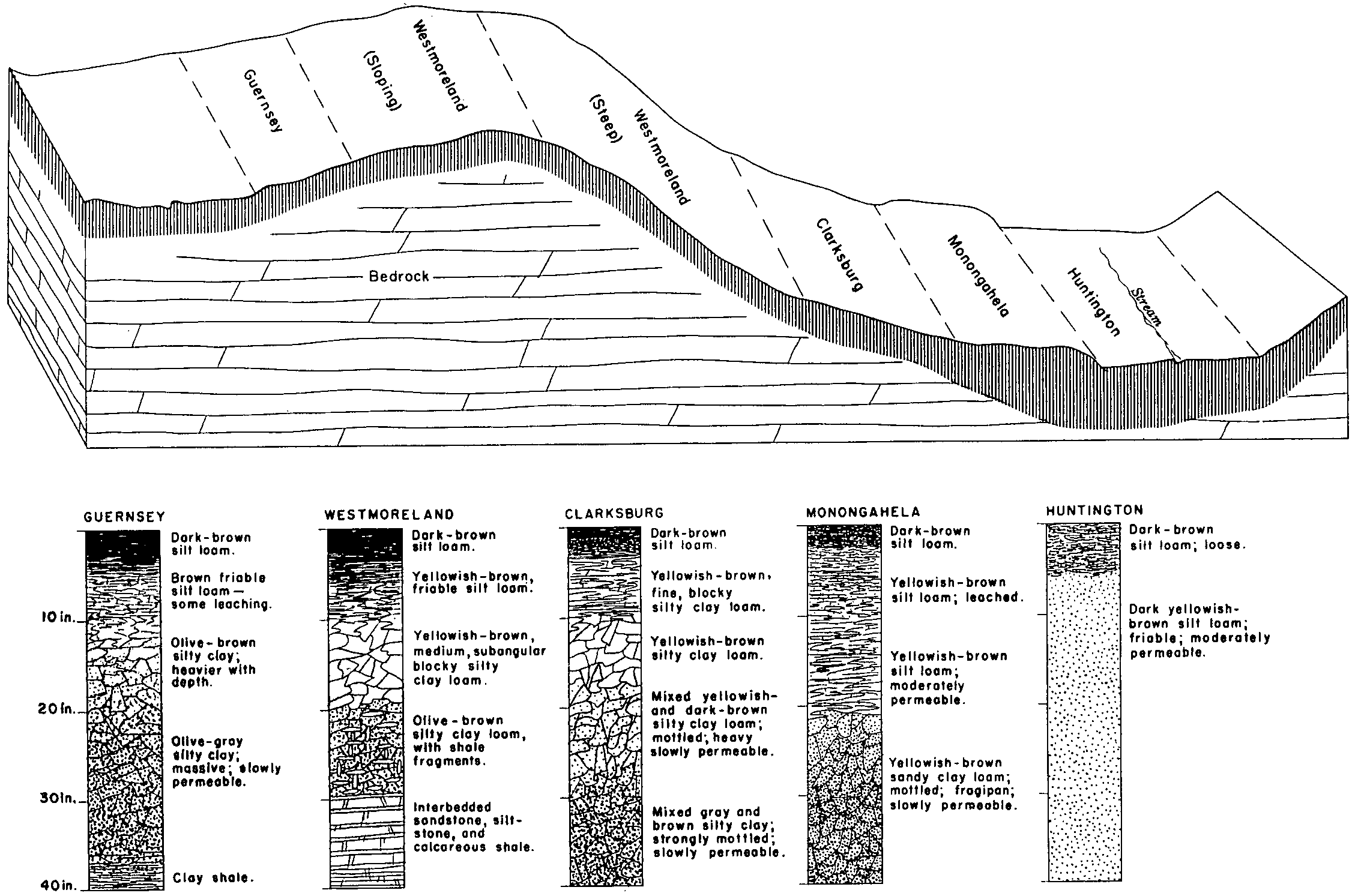
| Westmoreland-Guernsey silt loams, benched, 40 to 70 percent slopes | WkF | 23750 | 537409 | l16s | oh009 | 1981 | 1:15840 |
Westmoreland-Guernsey silt loams, 15 to 25 percent slopes | WhD | 21090 | 537406 | l16p | oh009 | 1981 | 1:15840 |
Westmoreland-Guernsey silt loams, 25 to 40 percent slopes | WhE | 14140 | 537407 | l16q | oh009 | 1981 | 1:15840 |
Guernsey-Upshur complex, 15 to 25 percent slopes | GuD | 9201 | 537367 | l15f | oh009 | 1981 | 1:15840 |
Guernsey silt loam, 8 to 15 percent slopes | GsC | 7389 | 537365 | 2t32f | oh009 | 1981 | 1:15840 |
Westmoreland-Guernsey silt loams, 40 to 70 percent slopes | WhF | 7380 | 537408 | l16r | oh009 | 1981 | 1:15840 |
Westmoreland-Guernsey silt loams, 8 to 15 percent slopes | WhC | 5620 | 537405 | l16n | oh009 | 1981 | 1:15840 |
Guernsey-Upshur complex, 8 to 15 percent slopes | GuC | 4203 | 537366 | l15d | oh009 | 1981 | 1:15840 |
Guernsey silt loam, 3 to 8 percent slopes | GsB | 2945 | 537364 | 2wdrv | oh009 | 1981 | 1:15840 |
Guernsey-Westmoreland silt loams, 15 to 25 percent slopes | GwD | 182 | 1008417 | 12vbl | oh009 | 1981 | 1:15840 |
Guernsey-Gilpin complex, 15 to 25 percent slopes | GxD | 100 | 1008374 | 12v96 | oh009 | 1981 | 1:15840 |
Gilpin-Guernsey complex, 15 to 25 percent slopes | GgD | 91 | 1008310 | 12v74 | oh009 | 1981 | 1:15840 |
Gilpin-Guernsey complex, 25 to 40 percent slopes | GgE | 66 | 1008311 | 12v75 | oh009 | 1981 | 1:15840 |
Guernsey-Westmoreland silt loams, 25 to 40 percent slopes | GwE | 43 | 1008418 | 12vbm | oh009 | 1981 | 1:15840 |
Guernsey-Gilpin complex, 25 to 40 percent slopes | GxE | 33 | 1008375 | 12v97 | oh009 | 1981 | 1:15840 |
Guernsey-Westmoreland silt loams, 8 to 15 percent slopes | GwC | 3 | 1008416 | 12vbk | oh009 | 1981 | 1:15840 |
Guernsey silty clay loam, 8 to 15 percent slopes, eroded | GuC2 | 1488 | 537988 | l1tg | oh019 | 1981 | 1:15840 |
Guernsey silty clay loam, 3 to 8 percent slopes | GuB | 943 | 537987 | l1tf | oh019 | 1981 | 1:15840 |
Coshocton-Guernsey silt loams, 15 to 25 percent slopes | CsD | 103 | 1589698 | 2z52p | oh019 | 1981 | 1:15840 |
Coshocton-Guernsey silt loams, 15 to 25 percent slopes, very stony | CtD | 63 | 1589699 | 2z52t | oh019 | 1981 | 1:15840 |
Coshocton-Guernsey silt loams, 8 to 15 percent slopes | CsC | 29 | 1589697 | 2z52r | oh019 | 1981 | 1:15840 |
Guernsey silt loam, 8 to 15 percent slopes | GnC | 1 | 1670689 | 2t32f | oh019 | 1981 | 1:15840 |
Guernsey silt loam, 8 to 15 percent slopes | GuC | 393 | 298784 | 2t32f | oh029 | 2005 | 1:12000 |
Guernsey silt loam, 6 to 15 percent slopes, eroded | GuC2 | 252 | 1413399 | 1jfrj | oh029 | 2005 | 1:12000 |
Guernsey silt loam, 15 to 25 percent slopes | GuD | 79 | 298785 | 2t32g | oh029 | 2005 | 1:12000 |
Guernsey silt loam, 15 to 25 percent slopes | GuD | 9244 | 536646 | 2t32g | oh031 | 1996 | 1:15840 |
Guernsey silt loam, 8 to 15 percent slopes | GuC | 1657 | 536645 | 2t32f | oh031 | 1996 | 1:15840 |
Coshocton-Guernsey silt loams, 15 to 25 percent slopes | CuD | 436 | 2108981 | 2z52p | oh031 | 1996 | 1:15840 |
Westmoreland-Guernsey silt loams, 25 to 40 percent slopes | WmE | 68 | 2108989 | 2t333 | oh031 | 1996 | 1:15840 |
Westmoreland-Guernsey silt loams, 15 to 25 percent slopes | WmD | 60 | 2108988 | 2t332 | oh031 | 1996 | 1:15840 |
Coshocton-Guernsey silt loams, 15 to 25 percent slopes, very stony | CvD | 2 | 2108982 | 2z52t | oh031 | 1996 | 1:15840 |
Guernsey-Gilpin association, steep | GwE | 7309 | 536812 | l0lj | oh053 | 1988 | 1:15840 |
Guernsey-Gilpin silt loams, 8 to 15 percent slopes | GsC | 973 | 536811 | l0lh | oh053 | 1988 | 1:15840 |
Guernsey-Upshur complex, 15 to 25 percent slopes | GuD | 21868 | 536912 | l0pr | oh059 | 1998 | 1:15840 |
Guernsey-Upshur complex, 8 to 15 percent slopes | GuC | 7759 | 536911 | l0pq | oh059 | 1998 | 1:15840 |
Guernsey silt loam, 15 to 25 percent slopes | GrD2 | 6109 | 536910 | 2t32g | oh059 | 1998 | 1:15840 |
Guernsey silt loam, 8 to 15 percent slopes | GrC | 1899 | 536909 | 2t32f | oh059 | 1998 | 1:15840 |
Claysville-Guernsey complex, 8 to 15 percent slopes | CkC | 580 | 536883 | l0nt | oh059 | 1998 | 1:15840 |
Guernsey-Upshur silty clay loams, 15 to 25 percent slopes, eroded | GvD2 | 2 | 1592922 | 1qgkl | oh059 | 1998 | 1:15840 |
Guernsey silty clay loam, 15 to 25 percent slopes, eroded | GuD2 | 24463 | 536747 | l0jf | oh067 | 1993 | 1:15840 |
Berks-Guernsey complex, 25 to 40 percent slopes | BnE | 4824 | 536718 | l0hh | oh067 | 1993 | 1:15840 |
Guernsey silty clay loam, 25 to 40 percent slopes, eroded | GuE2 | 4343 | 536748 | l0jg | oh067 | 1993 | 1:15840 |
Guernsey silt loam, 8 to 15 percent slopes | GtC | 2672 | 536746 | 2t32f | oh067 | 1993 | 1:15840 |
Berks-Guernsey complex, 15 to 25 percent slopes | BnD | 1123 | 536717 | l0hg | oh067 | 1993 | 1:15840 |
Guernsey silt loam, 15 to 25 percent slopes | GwD2 | 165 | 1695493 | 2t32g | oh067 | 1993 | 1:15840 |
Coshocton-Guernsey silt loams, 15 to 25 percent slopes | CrD | 107 | 1695499 | 2z52p | oh067 | 1993 | 1:15840 |
Berks-Guernsey complex, 8 to 15 percent slopes | BnC | 39 | 1695496 | 1tx9f | oh067 | 1993 | 1:15840 |
Coshocton-Guernsey silt loams, 25 to 40 percent slopes | CrE | 23 | 1695500 | 2z52q | oh067 | 1993 | 1:15840 |
Westmoreland-Guernsey silt loams, 15 to 25 percent slopes | WrD | 12 | 1695502 | 2t332 | oh067 | 1993 | 1:15840 |
Guernsey soils, 12 to 18 percent slopes, severely eroded | GxD3 | 737 | 1420426 | 1jp26 | oh071 | 1973 | 1:15840 |
Guernsey silt loam, 6 to 12 percent slopes | GuC | 157 | 1420424 | 1jp24 | oh071 | 1973 | 1:15840 |
Guernsey silty clay loam, 6 to 12 percent slopes, severely eroded | GvC3 | 150 | 1420425 | 1jp25 | oh071 | 1973 | 1:15840 |
Guernsey silt loam, 2 to 6 percent slopes | GuB | 127 | 1420423 | 1jp23 | oh071 | 1973 | 1:15840 |
Westmoreland-Guernsey silt loams, 25 to 40 percent slopes | WrE | 18001 | 1398112 | 1hxvd | oh073 | 1986 | 1:15840 |
Westmoreland-Guernsey silt loams, 15 to 25 percent slopes | WrD | 7439 | 1398111 | 1hxvc | oh073 | 1986 | 1:15840 |
Westmoreland-Guernsey silt loams, 40 to 70 percent slopes | WrF | 7392 | 1398113 | 1hxvf | oh073 | 1986 | 1:15840 |
Wellston-Guernsey silt loams, 8 to 15 percent slopes | WgC | 5254 | 1398105 | 1hxv5 | oh073 | 1986 | 1:15840 |
Gilpin-Guernsey complex, 25 to 40 percent slopes | GgE | 1009 | 1398171 | 1hxx9 | oh073 | 1986 | 1:15840 |
Guernsey silt loam, 8 to 15 percent slopes | GuC | 403 | 1398074 | 2t32f | oh073 | 1986 | 1:15840 |
Gilpin-Guernsey complex, 40 to 70 percent slopes | GgF | 374 | 1398172 | 1hxxb | oh073 | 1986 | 1:15840 |
Gilpin-Guernsey complex, 15 to 25 percent slopes | GgD | 240 | 1398170 | 1hxx8 | oh073 | 1986 | 1:15840 |
Guernsey-Westmoreland silt loams, 15 to 25 percent slopes | GwD | 22 | 1398241 | 1hxzk | oh073 | 1986 | 1:15840 |
Westmoreland-Guernsey silt loams, 8 to 15 percent slopes | WhC | 7 | 1398237 | 1hxzf | oh073 | 1986 | 1:15840 |
Coshocton-Guernsey silt loams, 15 to 25 percent slopes | CwD | 187 | 1677013 | 2z52p | oh075 | 1989 | 1:15840 |
Coshocton-Guernsey silt loams, 15 to 25 percent slopes, very stony | CxD | 151 | 1677015 | 2z52t | oh075 | 1989 | 1:15840 |
Westmoreland-Guernsey silt loams, 15 to 25 percent slopes | WkD | 74 | 1677020 | 2t332 | oh075 | 1989 | 1:15840 |
Coshocton-Guernsey silt loams, 25 to 40 percent slopes | CwE | 14 | 1677014 | 2z52q | oh075 | 1989 | 1:15840 |
Westmoreland-Guernsey silt loams, 8 to 15 percent slopes | WkC | 6 | 1677019 | 2t331 | oh075 | 1989 | 1:15840 |
Berks-Guernsey complex, 15 to 25 percent slopes | BmD | 9440 | 536056 | kzt4 | oh081 | 1987 | 1:15840 |
Berks-Guernsey complex, 8 to 15 percent slopes | BmC | 4400 | 536055 | kzt3 | oh081 | 1987 | 1:15840 |
Berks-Guernsey complex, 25 to 40 percent slopes | BmE | 3816 | 536057 | kzt5 | oh081 | 1987 | 1:15840 |
Guernsey silty clay loam, 7 to 15 percent slopes, eroded | GvC2 | 1418 | 536086 | kzv3 | oh081 | 1987 | 1:15840 |
Guernsey silt loam, 3 to 8 percent slopes | GuB | 975 | 536085 | 2wdrv | oh081 | 1987 | 1:15840 |
Guernsey silt loam, 6 to 15 percent slopes | GyC | 3 | 1652942 | 1sh0q | oh081 | 1987 | 1:15840 |
Guernsey silt loam, 12 to 18 percent slopes | GnD | 560 | 171034 | 5qz7 | oh089 | 1986 | 1:15840 |
Guernsey silt loam, 6 to 12 percent slopes, eroded | GnC2 | 345 | 171033 | 5qz6 | oh089 | 1986 | 1:15840 |
Guernsey silt loam, 3 to 8 percent slopes | GnB | 330 | 171032 | 2wdrv | oh089 | 1986 | 1:15840 |
Guernsey-Gilpin complex, 15 to 25 percent slopes | GwD | 718 | 537168 | l0z0 | oh105 | 1991 | 1:15840 |
Guernsey-Gilpin complex, 25 to 40 percent slopes | GwE | 231 | 537169 | l0z1 | oh105 | 1991 | 1:15840 |
Guernsey-Westmore silt loams, 18 to 35 percent slopes, moderately eroded | GwE2 | 10619 | 537798 | l1mb | oh111 | 1968 | 1:15840 |
Guernsey-Westmore silt loams, 35 to 70 percent slopes, moderately eroded | GwG2 | 8306 | 537800 | l1md | oh111 | 1968 | 1:15840 |
Guernsey-Upshur complex, 18 to 70 percent slopes, landslip | GsG | 4912 | 537793 | l1m5 | oh111 | 1968 | 1:15840 |
Guernsey-Westmore silt loams, 12 to 18 percent slopes, moderately eroded | GwD2 | 3949 | 537797 | l1m9 | oh111 | 1968 | 1:15840 |
Guernsey-Upshur complex, 18 to 35 percent slopes, moderately eroded | GrE2 | 3213 | 537791 | l1m3 | oh111 | 1968 | 1:15840 |
Guernsey-Upshur complex, 35 to 70 percent slopes, moderately eroded | GrG2 | 2428 | 537792 | l1m4 | oh111 | 1968 | 1:15840 |
Guernsey-Upshur complex, very steep, benched | GuG | 1053 | 537795 | l1m7 | oh111 | 1968 | 1:15840 |
Guernsey-Upshur complex, 12 to 18 percent slopes, moderately eroded | GrD2 | 913 | 537790 | l1m2 | oh111 | 1968 | 1:15840 |
Guernsey-Westmore silt loams, 6 to 12 percent slopes, moderately eroded | GwC2 | 493 | 537796 | l1m8 | oh111 | 1968 | 1:15840 |
Guernsey-Westmore silt loams, 18 to 35 percent slopes, severely eroded | GwE3 | 422 | 537799 | l1mc | oh111 | 1968 | 1:15840 |
Guernsey-Upshur complex, steep, benched | GuE | 245 | 537794 | l1m6 | oh111 | 1968 | 1:15840 |
Guernsey silt loam, 15 to 25 percent slopes | GtD | 234 | 1469258 | 1l9wf | oh111 | 1968 | 1:15840 |
Guernsey-Upshur complex, 6 to 12 percent slopes, moderately eroded | GrC2 | 148 | 537789 | l1m1 | oh111 | 1968 | 1:15840 |
Guernsey silt loam, 6 to 15 percent slopes | GtC | 5 | 1469257 | 1l9wd | oh111 | 1968 | 1:15840 |
Elba-Guernsey silty clay loams, 15 to 25 percent slopes, eroded | EdD2 | 3 | 1469248 | 1l9w3 | oh111 | 1968 | 1:15840 |
Guernsey-Upshur complex, 12 to 20 percent slopes, eroded | GsD2 | 22000 | 537440 | l17s | oh115 | 1992 | 1:15840 |
Westmoreland-Guernsey complex, 35 to 70 percent slopes | WgF | 14129 | 537476 | l18y | oh115 | 1992 | 1:15840 |
Westmoreland-Guernsey complex, 12 to 20 percent slopes, eroded | WgD2 | 4271 | 537474 | l18w | oh115 | 1992 | 1:15840 |
Westmoreland-Guernsey complex, 20 to 35 percent slopes, eroded | WgE2 | 3310 | 537475 | l18x | oh115 | 1992 | 1:15840 |
Claysville-Guernsey complex, 8 to 15 percent slopes | CgC | 1757 | 537428 | l17d | oh115 | 1992 | 1:15840 |
Guernsey-Upshur silty clay loams, 15 to 25 percent slopes, eroded | GtD2 | 480 | 1541142 | 1nqp8 | oh115 | 1992 | 1:15840 |
Westmoreland-Guernsey silt loams, 15 to 25 percent slopes, eroded | WhD2 | 246 | 1541160 | 1nqpv | oh115 | 1992 | 1:15840 |
Westmoreland-Guernsey silt loams, 25 to 40 percent slopes, eroded | WhE2 | 107 | 1541161 | 1nqpw | oh115 | 1992 | 1:15840 |
Guernsey-Upshur silty clay loams, 6 to 15 percent slopes, eroded | GtC2 | 5 | 1541140 | 1nqp6 | oh115 | 1992 | 1:15840 |
Westmoreland-Guernsey silt loams, 15 to 25 percent slopes, eroded | WuD2 | 12124 | 537958 | l1sh | oh119 | 1989 | 1:15840 |
Guernsey-Upshur silty clay loams, 6 to 15 percent slopes, eroded | GtC2 | 11243 | 537895 | l1qg | oh119 | 1989 | 1:15840 |
Westmoreland-Guernsey silt loams, 25 to 40 percent slopes, eroded | WuE2 | 11024 | 537959 | l1sj | oh119 | 1989 | 1:15840 |
Guernsey-Upshur silty clay loams, 15 to 25 percent slopes, eroded | GtD2 | 7552 | 537896 | l1qh | oh119 | 1989 | 1:15840 |
Westmoreland-Guernsey silt loams, 8 to 15 percent slopes, eroded | WuC2 | 1053 | 537957 | l1sg | oh119 | 1989 | 1:15840 |
Claysville-Guernsey silty clay loams, 8 to 15 percent slopes | CrC | 1053 | 537876 | l1pv | oh119 | 1989 | 1:15840 |
Guernsey-Upshur complex, 8 to 15 percent slopes | GsC | 125 | 1425628 | 1jvh0 | oh119 | 1989 | 1:15840 |
Guernsey silt loam, 15 to 25 percent slopes, eroded | GpD2 | 43 | 1425627 | 1jvgz | oh119 | 1989 | 1:15840 |
Guernsey silt loam, 15 to 25 percent slopes | GpD | 17 | 1425656 | 1jvhx | oh119 | 1989 | 1:15840 |
Guernsey silt loam, 12 to 18 percent slopes | GnD | 13 | 1425646 | 1jvhl | oh119 | 1989 | 1:15840 |
Vandalia-Guernsey silty clay loams, 15 to 25 percent slopes, eroded | VcD2 | 19000 | 537041 | l0tx | oh121 | 1986 | 1:15840 |
Guernsey silt loam, 15 to 25 percent slopes | GuD | 7300 | 537008 | l0sv | oh121 | 1986 | 1:15840 |
Elba-Guernsey silty clay loams, 25 to 35 percent slopes, eroded | EdE2 | 7000 | 536995 | l0sf | oh121 | 1986 | 1:15840 |
Guernsey silt loam, 8 to 15 percent slopes | GuC | 3066 | 537007 | 2t32f | oh121 | 1986 | 1:15840 |
Elba-Guernsey silty clay loams, 15 to 25 percent slopes, eroded | EdD2 | 2900 | 536994 | l0sd | oh121 | 1986 | 1:15840 |
Vandalia-Guernsey silty clay loams, 25 to 35 percent slopes, eroded | VcE2 | 1700 | 537042 | l0ty | oh121 | 1986 | 1:15840 |
Guernsey-Upshur silty clay loams, 15 to 25 percent slopes, eroded | GwD2 | 980 | 537009 | l0sw | oh121 | 1986 | 1:15840 |
Vandalia-Guernsey silty clay loams, 8 to 15 percent slopes, eroded | VcC2 | 700 | 537040 | l0tw | oh121 | 1986 | 1:15840 |
Guernsey silt loam, 3 to 8 percent slopes | GuB | 200 | 537006 | 2wdrv | oh121 | 1986 | 1:15840 |
Guernsey-Upshur complex, 15 to 25 percent slopes | GxD | 107 | 1481806 | 1lqy6 | oh121 | 1986 | 1:15840 |
Guernsey silt loam, 15 to 25 percent slopes, eroded | GuD2 | 82 | 1481805 | 1lqy5 | oh121 | 1986 | 1:15840 |
Guernsey-Westmoreland silt loams, 15 to 25 percent slopes | GwD | 23611 | 537543 | l1c3 | oh127 | 1984 | 1:15840 |
Guernsey-Westmoreland silt loams, 25 to 40 percent slopes | GwE | 20191 | 537544 | l1c4 | oh127 | 1984 | 1:15840 |
Westmoreland-Guernsey silt loams, 40 to 70 percent slopes | WsF | 16895 | 537601 | l1dz | oh127 | 1984 | 1:15840 |
Guernsey-Westmoreland silt loams, 8 to 15 percent slopes | GwC | 14435 | 537542 | l1c2 | oh127 | 1984 | 1:15840 |
Westmoreland-Guernsey silt loams, 8 to 15 percent slopes, eroded | WrC2 | 521 | 1541666 | 1nr75 | oh127 | 1984 | 1:15840 |
Westmoreland-Guernsey silt loams, 15 to 25 percent slopes, eroded | WrD2 | 415 | 1541667 | 1nr76 | oh127 | 1984 | 1:15840 |
Westmoreland-Guernsey silt loams, 25 to 40 percent slopes, eroded | WrE2 | 246 | 1541668 | 1nr77 | oh127 | 1984 | 1:15840 |
Coshocton-Guernsey silt loams, 15 to 25 percent slopes | CsD | 78 | 1595461 | 2z52p | oh151 | 1967 | 1:15840 |
Coshocton-Guernsey silt loams, 8 to 15 percent slopes | CsC | 37 | 1595460 | 2z52r | oh151 | 1967 | 1:15840 |
Guernsey silt loam, 8 to 15 percent slopes | GmC | 16 | 1595466 | 2t32f | oh151 | 1967 | 1:15840 |
Coshocton-Guernsey silt loams, 15 to 25 percent slopes, very stony | CxD | 12 | 1595464 | 2z52t | oh151 | 1967 | 1:15840 |
Coshocton-Guernsey silt loams, 25 to 40 percent slopes | CsE | 6 | 1595462 | 2z52q | oh151 | 1967 | 1:15840 |
Coshocton-Guernsey silt loams, 8 to 15 percent slopes, very stony | CxC | 4 | 1595463 | 2z52s | oh151 | 1967 | 1:15840 |
Guernsey silty clay loam, 3 to 8 percent slopes | GnB | 2 | 1595490 | 1qk7f | oh151 | 1967 | 1:15840 |
Coshocton-Guernsey silt loams, 15 to 25 percent slopes | CsD | 42775 | 536299 | 2z52p | oh157 | 1981 | 1:15840 |
Coshocton-Guernsey silt loams, 8 to 15 percent slopes | CsC | 17422 | 536298 | 2z52r | oh157 | 1981 | 1:15840 |
Westmoreland-Guernsey silt loams, 15 to 25 percent slopes | WnD | 8510 | 536349 | 2t332 | oh157 | 1981 | 1:15840 |
Coshocton-Guernsey silt loams, 25 to 40 percent slopes | CsE | 5200 | 536300 | 2z52q | oh157 | 1981 | 1:15840 |
Guernsey silt loam, 15 to 25 percent slopes | GgD | 4610 | 536313 | 2t32g | oh157 | 1981 | 1:15840 |
Coshocton-Guernsey silt loams, 15 to 25 percent slopes, very stony | CtD | 4500 | 536302 | 2z52t | oh157 | 1981 | 1:15840 |
Westmoreland-Guernsey silt loams, 25 to 40 percent slopes | WnE | 3655 | 536350 | 2t333 | oh157 | 1981 | 1:15840 |
Guernsey silt loam, 8 to 15 percent slopes | GgC | 3259 | 536312 | 2t32f | oh157 | 1981 | 1:15840 |
Westmoreland-Guernsey silt loams, 8 to 15 percent slopes | WnC | 2350 | 536348 | 2t331 | oh157 | 1981 | 1:15840 |
Guernsey silt loam, 3 to 8 percent slopes | GgB | 1520 | 536311 | 2wdrv | oh157 | 1981 | 1:15840 |
Coshocton-Guernsey silt loams, 8 to 15 percent slopes, very stony | CtC | 460 | 536301 | 2z52s | oh157 | 1981 | 1:15840 |
Guernsey silt loam, 15 to 25 percent slopes, eroded | GgD2 | 130 | 1589375 | 1qbw5 | oh157 | 1981 | 1:15840 |
Guernsey silty clay loam, 15 to 25 percent slopes, eroded | GrD2 | 53 | 1589389 | 1qbwm | oh157 | 1981 | 1:15840 |
Guernsey silty clay loam, 8 to 15 percent slopes, eroded | GrC2 | 24 | 1589443 | 1qbyc | oh157 | 1981 | 1:15840 |
Gilpin-Guernsey complex, 25 to 40 percent slopes | GgE | 3043 | 536391 | l04y | oh163 | 1998 | 1:15840 |
Gilpin-Guernsey complex, 15 to 25 percent slopes | GgD | 1374 | 536390 | l04x | oh163 | 1998 | 1:15840 |
Gilpin-Guernsey complex, 40 to 70 percent slopes | GgF | 144 | 536392 | l04z | oh163 | 1998 | 1:15840 |
Urban land-Guernsey complex, moderately steep | UGD | 12067 | 541727 | l5q2 | pa003 | 1973 | 1:15840 |
Urban land-Guernsey complex, gently sloping | UGB | 6540 | 541726 | l5q1 | pa003 | 1973 | 1:15840 |
Guernsey silt loam, 8 to 15 percent slopes | GuC | 6359 | 541696 | 2t32f | pa003 | 1973 | 1:15840 |
Guernsey-Vandergrift silt loams, 8 to 15 percent slopes | GvC | 6290 | 541699 | l5p5 | pa003 | 1973 | 1:15840 |
Guernsey silt loam, 15 to 25 percent slopes | GuD | 6062 | 541697 | 2t32g | pa003 | 1973 | 1:15840 |
Guernsey-Vandergrift silt loams, 15 to 25 percent slopes | GvD | 3245 | 541700 | l5p6 | pa003 | 1973 | 1:15840 |
Guernsey silt loam, 3 to 8 percent slopes | GuB | 2884 | 541695 | 2wdrv | pa003 | 1973 | 1:15840 |
Guernsey-Vandergrift silt loams, 3 to 8 percent slopes | GvB | 1424 | 541698 | l5p4 | pa003 | 1973 | 1:15840 |
Guernsey silt loam, 3 to 8 percent slopes | GyB | 107 | 3180040 | 2wdrv | pa005 | 2012 | 1:24000 |
Guernsey silt loam, 8 to 15 percent slopes | GyC | 36 | 3180042 | 2t32f | pa005 | 2012 | 1:24000 |
Guernsey-Vandergrift complex, 8 to 15 percent slopes | GvC | 4165 | 2900280 | l6lh | pa007 | 1978 | 1:15840 |
Guernsey-Vandergrift complex, 15 to 25 percent slopes | GvD | 3090 | 2900281 | l6lj | pa007 | 1978 | 1:15840 |
Guernsey silt loam, 8 to 15 percent slopes | GtC | 2294 | 2900278 | 2t32f | pa007 | 1978 | 1:15840 |
Guernsey-Vandergrift complex, 3 to 8 percent slopes | GvB | 1229 | 2900279 | l6lg | pa007 | 1978 | 1:15840 |
Guernsey silt loam, 3 to 8 percent slopes | GtB | 1180 | 2900277 | 2wdrv | pa007 | 1978 | 1:15840 |
Guernsey silt loam, 3 to 8 percent slopes | GyB | 350 | 2408621 | 2wdrv | pa031 | 2012 | 1:24000 |
Guernsey silt loam, 8 to 15 percent slopes | GyC | 237 | 2408622 | 2t32f | pa031 | 2012 | 1:24000 |
Guernsey silt loam, 15 to 25 percent slopes | GyD | 77 | 2408623 | 2t32g | pa031 | 2012 | 1:24000 |
Guernsey silt loam, 8 to 15 percent slopes | GyC | 13670 | 1591046 | 2t32f | pa051 | 2005 | 1:24000 |
Guernsey silt loam, 3 to 8 percent slopes | GyB | 8317 | 1591045 | 2wdrv | pa051 | 2005 | 1:24000 |
Guernsey silt loam, 15 to 25 percent slopes | GyD | 3543 | 1591047 | 2t32g | pa051 | 2005 | 1:24000 |
Urban land-Guernsey complex, 0 to 8 percent slopes | UhB | 1294 | 1591124 | 1qdpl | pa051 | 2005 | 1:24000 |
Urban land-Guernsey complex, 8 to 25 percent slopes | UhD | 1075 | 1591125 | 1qdpm | pa051 | 2005 | 1:24000 |
Guernsey silt loam, 8 to 15 percent slopes | GyC | 644 | 1720891 | 2t32f | pa063 | 2012 | 1:24000 |
Guernsey silt loam, 3 to 8 percent slopes | GyB | 507 | 1720890 | 2wdrv | pa063 | 2012 | 1:24000 |
Guernsey silt loam, 3 to 8 percent slopes | GyB | 1171 | 3180041 | 2wdrv | pa065 | 2012 | 1:12000 |
Guernsey silt loam, 8 to 15 percent slopes | GyC | 100 | 2408085 | 2t32f | pa065 | 2012 | 1:12000 |
Guernsey silt loam, 8 to 15 percent slopes | GtC | 20 | 2900430 | 2t32f | pa073 | 1978 | 1:15840 |
Guernsey silt loam, 3 to 8 percent slopes | GtB | 5 | 2900429 | 2wdrv | pa073 | 1978 | 1:15840 |
Guernsey silt loam, 8 to 15 percent slopes | GyC | 11282 | 544638 | 2t32f | pa129 | 2003 | 1:24000 |
Guernsey silt loam, 3 to 8 percent slopes | GyB | 9483 | 544637 | 2wdrv | pa129 | 2003 | 1:24000 |
Urban land-Guernsey complex, 8 to 25 percent slopes | UhD | 4968 | 557497 | lq3s | pa129 | 2003 | 1:24000 |
Urban land-Guernsey complex, 0 to 8 percent slopes | UhB | 3939 | 544598 | l8pp | pa129 | 2003 | 1:24000 |
Guernsey silt loam, 15 to 25 percent slopes | GyD | 1604 | 544639 | 2t32g | pa129 | 2003 | 1:24000 |
Guernsey silt loam, 8 to 15 percent slopes | GeC | 25272 | 542160 | 2t32f | pa611 | 1979 | 1:15840 |
Guernsey silt loam, 15 to 25 percent slopes | GeD | 13051 | 542161 | 2t32g | pa611 | 1979 | 1:15840 |
Guernsey silt loam, 3 to 8 percent slopes | GeB | 10785 | 542159 | 2wdrv | pa611 | 1979 | 1:15840 |
Guernsey silt loam, 2 to 10 percent slopes | 47C | 1458 | 517844 | kcvn | va015 | 1978 | 1:15840 |
Guernsey silt loam, 2 to 7 percent slopes | 20B | 954 | 521082 | kh73 | va069 | 1983 | 1:15840 |
Guernsey silt loam, 7 to 15 percent slopes | 20C | 299 | 521083 | kh74 | va069 | 1983 | 1:15840 |
Guernsey silt loam, 2 to 7 percent slopes | 19B | 1766 | 517090 | kc2b | va121 | 1980 | 1:15840 |
Guernsey silt loam, 2 to 7 percent slopes | 35B | 2735 | 518402 | kdfn | va165 | 1980 | 1:20000 |
Guernsey silt loam, 2 to 7 percent slopes | 27B | 2545 | 522137 | kjb4 | va185 | 1996 | 1:24000 |
Guernsey silt loam, 7 to 15 percent slopes | 27C | 398 | 522138 | kjb5 | va185 | 1996 | 1:24000 |
Guernsey silt loam, 15 to 25 percent slopes | GuD | 587 | 1720650 | 2t32g | wv051 | 2007 | 1:12000 |
Guernsey silt loam, 8 to 15 percent slopes | GuC | 192 | 1720649 | 2t32f | wv051 | 2007 | 1:12000 |
Guernsey silt loam, 3 to 8 percent slopes | GuB | 5 | 1860679 | 2wdrv | wv051 | 2007 | 1:12000 |
Guernsey silt loam, 8 to 15 percent slopes | GuC | 1619 | 1713187 | 2t32f | wv604 | 1970 | 1:20000 |
Guernsey silt loam, 3 to 8 percent slopes | GuB | 1419 | 1713186 | 2wdrv | wv604 | 1970 | 1:20000 |
Guernsey silt loam, 15 to 25 percent slopes | GuD | 316 | 1713188 | 2t32g | wv604 | 1970 | 1:20000 |
Guernsey silt loam, 15 to 25 percent slopes, severely eroded | GuD3 | 112 | 1713189 | 1vhq5 | wv604 | 1970 | 1:20000 |
Guernsey silt loam, 8 to 15 percent slopes | GyC | 6809 | 515814 | 2t32f | wv610 | 1973 | 1:20000 |
Guernsey silt loam, 15 to 25 percent slopes | GyD | 4037 | 515815 | 2t32g | wv610 | 1973 | 1:20000 |
Guernsey silt loam, 15 to 25 percent slopes, severely eroded | GyD3 | 490 | 515816 | k9r7 | wv610 | 1973 | 1:20000 |
Guernsey silt loam, 3 to 8 percent slopes | GyB | 308 | 515813 | 2wdrv | wv610 | 1973 | 1:20000 |
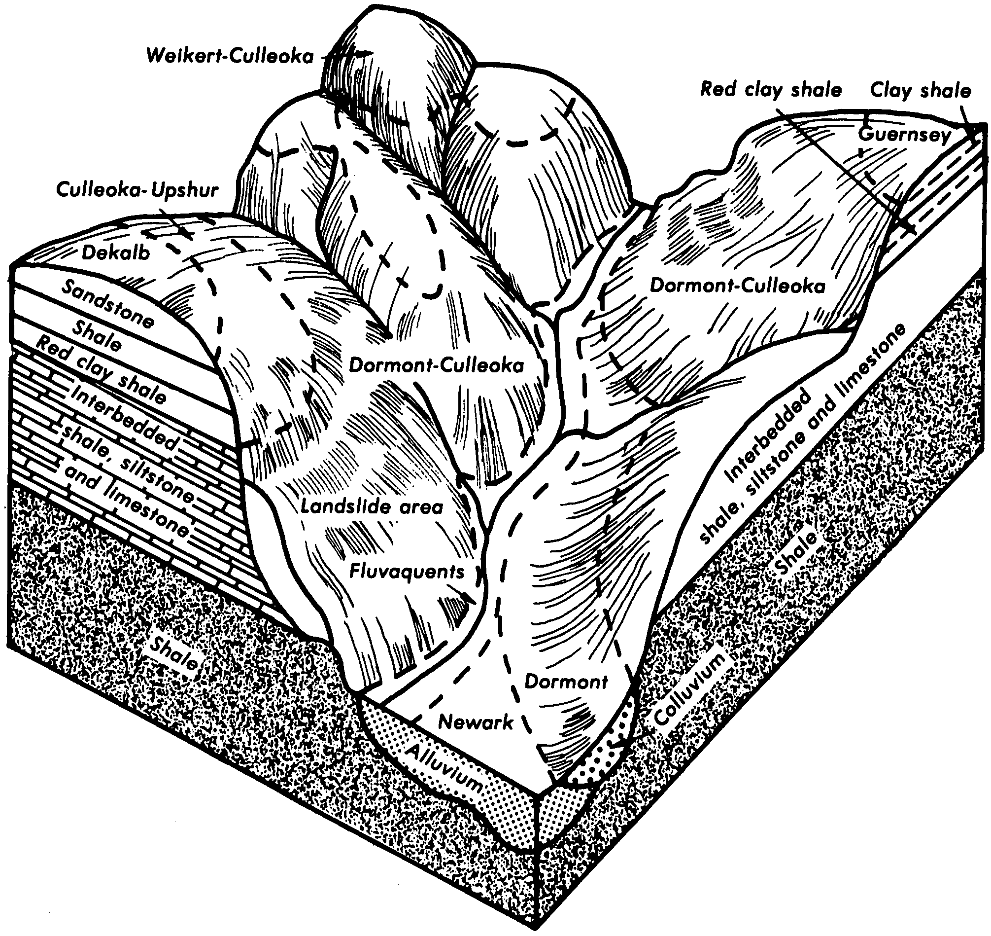
Dormont and Guernsey silt loams, 15 to 25 percent slopes | DgD | 11890 | 514371 | k87m | wv611 | 1977 | 1:20000 |
Dormont and Guernsey silt loams, 8 to 15 percent slopes | DgC | 8195 | 514370 | k87l | wv611 | 1977 | 1:20000 |
Dormont and Guernsey silt loams, 3 to 8 percent slopes | DgB | 1023 | 514369 | k87k | wv611 | 1977 | 1:20000 |
Guernsey silt loam, 3 to 8 percent slopes | GuB | 5 | 2516617 | 2619q | wv713 | | 1:24000 |