Masham-Ashport frequently flooded complex, 0 to 20 percent slopes
Masham
(69%)
Shallow Clay Upland
Udic Haplustepts
Well drained
Hydric: No
PAWS: 5 cm
hillslopes / Backslope
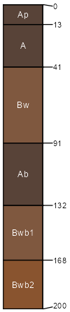
Ashport
(16%)
Loamy Bottomland
Fluventic Haplustolls
Well drained
Hydric: No
PAWS: 35 cm
flood plains
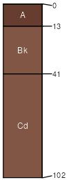
Ironmound
(5%)
Shallow Upland
Udic Haplustepts
Well drained
Hydric: No
PAWS: 6 cm
hillslopes / Backslope
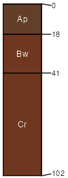
Kingfisher
(5%)
Loamy Upland
Udic Argiustolls
Well drained
Hydric: No
PAWS: 13 cm
hillslopes / Backslope
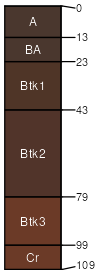
Grainola
(5%)
Claypan Upland (North)
Udertic Haplustalfs
Well drained
Hydric: No
PAWS: 13 cm
hillslopes / Backslope
SSA
Scale
Published
Export
ok053
1:24,000
1983
2025-08-29