Samsil-Cromack complex, 10 to 30 percent slopes
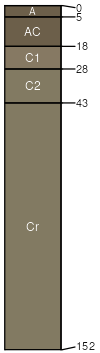
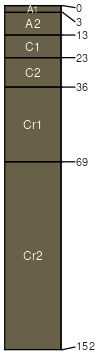
Samsil
(60%)
Shallow Clay
Aridic Ustorthents
Well drained
Hydric: No
PAWS: 7 cm
hillslopes / Summit
hillslopes / Backslope
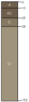
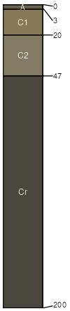
Cromack
(30%)
Clayey-West (16-20 PZ)
Torrertic Ustorthents
Well drained
Hydric: No
PAWS: 12 cm
hillslopes / Backslope
hillslopes / Footslope
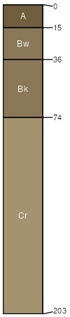
Cromack
(2%)
Clayey-West (16-20 PZ)
Torrertic Haplustepts
Well drained
Hydric: No
PAWS: 12 cm
hillslopes / Backslope
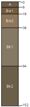
Echeta
(2%)
Clayey-West (16-20 PZ)
Torrertic Haplustepts
Well drained
Hydric: No
PAWS: 21 cm
hillslopes / Backslope
Fairburn
(2%)
Shallow Loamy-West (16-20 PZ)
Aridic Ustorthents
Well drained
Hydric: No
PAWS: 10 cm
ridges / Summit
ridges / Shoulder
Lismas
(2%)
Shallow Clayey (SwCy) 15-19 Precipitation Zone, Black Hills
Aridic Ustorthents
Well drained
Hydric: No
PAWS: 9 cm
hillslopes / Shoulder
hillslopes / Backslope
Orella
(1%)
Saline Upland
Aridic Ustorthents
Well drained
Hydric: No
PAWS: 3 cm
hills / Summit
hills / Shoulder
Leiter
(1%)
Clayey-West (16-20 PZ)
Aridic Haplustalfs
Well drained
Hydric: No
PAWS: 15 cm
hillslopes / Backslope
SSA
Scale
Published
Export
sd019
1:24,000
1970
2025-09-10