Mittenbutte-Fairburn complex, moist, 10 to 30 percent slopes
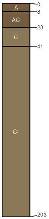
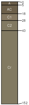
Mittenbutte
(50%)
Shallow Sandy-West (16-20 PZ)
Aridic Ustorthents
Well drained
Hydric: No
PAWS: 8 cm
ridges / Summit
ridges / Shoulder
ridges / Backslope
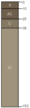
Fairburn
(30%)
Shallow Loamy-West (16-20 PZ)
Aridic Ustorthents
Well drained
Hydric: No
PAWS: 10 cm
ridges / Summit
ridges / Shoulder
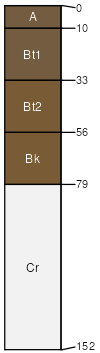
Xema
(5%)
Sandy
Aridic Haplustalfs
Well drained
Hydric: No
PAWS: 12 cm
hillslopes / Backslope
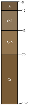
Ucross
(5%)
Loamy-West (16-20 PZ)
Aridic Ustorthents
Well drained
Hydric: No
PAWS: 12 cm
hillslopes
Samsil
(5%)
Shallow Clayey (SwCy) 15-19 Precipitation Zone, Black Hills
Aridic Ustorthents
Well drained
Hydric: No
PAWS: 7 cm
hillslopes / Summit
hillslopes / Backslope
Rock outcrop
(5%)
Non-site
Excessively drained
Hydric: No
PAWS: 6 cm
SSA
Scale
Published
Export
wy045
1:24,000
1984
2025-09-04