Lismas, moist-Badland, shale complex, 25 to 50 percent slopes
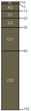
Lismas
(60%)
Shallow Clayey (SwCy) 15-19 Precipitation Zone, Black Hills
Aridic Ustorthents
Well drained
Hydric: No
PAWS: 3 cm
ridges / Shoulder
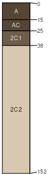
Badland
(20%)
Non-site
Excessively drained
Hydric: No
PAWS: 3 cm
ridges / Shoulder
valley sides / Shoulder
valley sides / Backslope
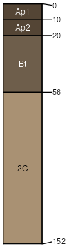
Dix
(10%)
Shallow Loamy-North (18-22 PZ)
Torriorthentic Haplustolls
Excessively drained
Hydric: No
PAWS: 6 cm
terraces / Summit
terraces / Backslope
Mawer
(5%)
Sandy
Aridic Argiustolls
Well drained
Hydric: No
PAWS: 12 cm
terraces / Summit
terraces / Backslope
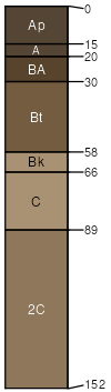
Altvan
(5%)
Loamy-North (18-22 PZ)
Typic Argiustolls
Well drained
Hydric: No
PAWS: 16 cm
hillslopes / Backslope
SSA
Scale
Published
Export
sd019
1:24,000
1970
2025-09-10