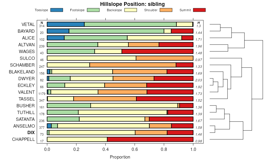
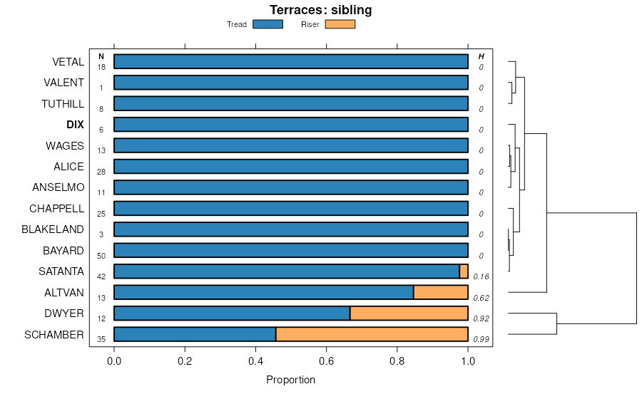
| Dix-Eckley complex, 5 to 25 percent slopes | 25 | 18680 | 94505 | 35bk | co075 | 1974 | 1:24000 |
Dix-Altvan complex, 10 to 30 percent slopes | 24 | 17225 | 94504 | 2tlqb | co075 | 1974 | 1:24000 |
Wages-Eckley-Dix complex, 5 to 25 percent slopes | WeE | 8145 | 94791 | 35ms | co095 | 1971 | 1:20000 |
Chappell and Dix sandy loams, 0 to 3 percent slopes | CdB | 1791 | 94772 | 35m5 | co095 | 1971 | 1:20000 |
Eckley-Dix-Blakeland complex, 6 to 20 percent slopes | 26 | 8999 | 95117 | 35z9 | co617 | 1980 | 1:24000 |
Altvan-Dix complex, 6 to 10 percent slopes | 78 | 44 | 95177 | 2tlq8 | co617 | 1980 | 1:24000 |
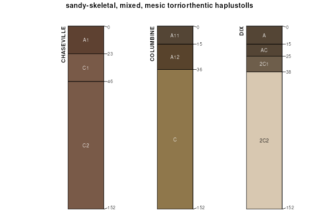
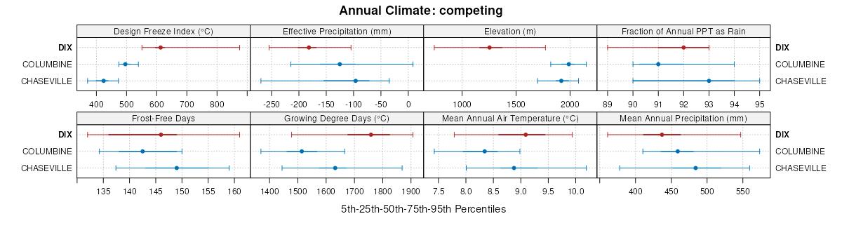
Dix soils, 6 to 40 percent slopes | 1595 | 4168 | 1150664 | 31rhk | ks063 | 1974 | 1:24000 |
Bayard-Dix complex, 9 to 20 percent slopes | 1316 | 10805 | 1692463 | 1tt4l | ne007 | 1988 | 1:20000 |
Bayard-Dix complex, 3 to 9 percent slopes | 1315 | 7763 | 1692462 | 1tt4k | ne007 | 1988 | 1:20000 |
Dix sandy loam, 0 to 3 percent slopes | 1368 | 245 | 1692476 | 1tt50 | ne007 | 1988 | 1:20000 |
Altvan-Dix complex, 3 to 9 percent slopes | 1506 | 15306 | 1698655 | 2tlq7 | ne033 | 1989 | 1:20000 |
Dix gravelly loam, 3 to 9 percent slopes | 1572 | 11429 | 1698675 | 1v0lz | ne033 | 1989 | 1:20000 |
Dix gravelly loam, 9 to 50 percent slopes | 1571 | 8482 | 1698676 | 1v0m0 | ne033 | 1989 | 1:20000 |
Dix-Sulco-Sarben complex, 20 to 60 percent slopes | 1576 | 9341 | 1698882 | 1v0tn | ne101 | 1990 | 1:20000 |
Altvan-Dix complex, 6 to 30 percent slopes | 1507 | 8125 | 1698870 | 2tlq9 | ne101 | 1990 | 1:20000 |
Satanta-Dix complex, 3 to 9 percent slopes | 1824 | 6512 | 1698914 | 1v0vp | ne101 | 1990 | 1:20000 |
Dix gravelly loam, 3 to 20 percent slopes | 1573 | 4349 | 1698881 | 1v0tm | ne101 | 1990 | 1:20000 |
Sulco-Dix complex, 9 to 20 percent slopes | 1836 | 3388 | 1698917 | 1v0vs | ne101 | 1990 | 1:20000 |
Tassel and Dix and Altvan soils, 9 to 30 percent slopes | 6023 | 10234 | 1692559 | 1tt7p | ne105 | 2004 | 1:24000 |
Dix complex, 6 to 30 percent slopes | 1570 | 2867 | 1699160 | 1v13m | ne111 | 1971 | 1:24000 |
Dix gravelly loam, 3 to 20 percent slopes | 1573 | 313 | 2219723 | 2dhsz | ne111 | 1971 | 1:24000 |
Dix loamy coarse sand, 6 to 50 percent slopes | 1574 | 14990 | 1692601 | 1tt91 | ne123 | 1981 | 1:20000 |
Alice-Dix complex, 6 to 20 percent slopes | 5907 | 7942 | 1692573 | 1tt84 | ne123 | 1981 | 1:20000 |
Altvan-Dix complex, 3 to 9 percent slopes | 1506 | 1809 | 1692575 | 2tlq7 | ne123 | 1981 | 1:20000 |
Alice-Dix complex, 3 to 6 percent slopes | 5906 | 948 | 1692572 | 1tt83 | ne123 | 1981 | 1:20000 |
Alice-Dix complex, 0 to 3 percent slopes | 5905 | 916 | 1692571 | 1tt82 | ne123 | 1981 | 1:20000 |
Dix gravelly loam, 9 to 50 percent slopes | 1571 | 265 | 2220386 | 2djhc | ne123 | 1981 | 1:20000 |
Bayard-Dix complex, 9 to 20 percent slopes | 1316 | 86 | 2220378 | 2djh3 | ne123 | 1981 | 1:20000 |
Altvan-Dix complex, 6 to 30 percent slopes | 1507 | 1214 | 1698954 | 2tlq9 | ne135 | 1987 | 1:20000 |
Dix-Bayard complex, 6 to 20 percent slopes | 1575 | 3428 | 1653733 | 1shv7 | ne157 | 1965 | 1:20000 |
Dix complex, 6 to 30 percent slopes | 1570 | 1353 | 1653737 | 1shvc | ne157 | 1965 | 1:20000 |
Chappell-Dix complex, 3 to 6 percent slopes | 1375 | 1107 | 1653732 | 1shv6 | ne157 | 1965 | 1:20000 |
Alice-Dix complex, 3 to 6 percent slopes | 5906 | 662 | 2227693 | 2ds32 | ne157 | 1965 | 1:20000 |
Altvan-Dix complex, 3 to 9 percent slopes | 1506 | 205 | 2227680 | 2tlq7 | ne157 | 1965 | 1:20000 |
Dix loamy coarse sand, 6 to 50 percent slopes | 1574 | 42 | 2227682 | 2ds2q | ne157 | 1965 | 1:20000 |
Bayard-Dix complex, 3 to 9 percent slopes | 1315 | 10 | 2227640 | 2ds1c | ne157 | 1965 | 1:20000 |
Dix sandy loam, 0 to 3 percent slopes | DsA | 684 | 3333645 | 2zj4y | sd019 | 1970 | 1:24000 |
Dix-Chappell fine sandy loams, 3 to 9 percent slopes | DcC | 3352 | 352982 | cv9j | sd121 | 1967 | 1:31680 |
Schamber-Dix complex, 9 to 25 percent slopes | Gr | 1002 | 352992 | cv9v | sd121 | 1967 | 1:31680 |
Dix soils, 9 to 18 percent slopes | DbD | 3823 | 354384 | cwrr | sd123 | 1975 | 1:20000 |
Chappell-Dix fine sandy loams, 6 to 9 percent slopes | CnC | 3165 | 354382 | cwrp | sd123 | 1975 | 1:20000 |
Dix fine sandy loam, 0 to 3 percent slopes | DaA | 245 | 354383 | cwrq | sd123 | 1975 | 1:20000 |
Dix complex, 10 to 40 percent slopes | DcE | 10557 | 104683 | 3hxw | wy615 | 1965 | 1:20000 |
Dix complex, 0 to 10 percent slopes | DcD | 1034 | 104682 | 3hxv | wy615 | 1965 | 1:20000 |
Chappell complex, 10 to 15 percent slopes | CID | 838 | 104672 | 3hxj | wy615 | 1965 | 1:20000 |
Altvan-Dix complex, 6 to 10 percent slopes | 7 | 35199 | 104844 | 2tlq8 | wy621 | 1980 | 1:24000 |
Dix-Altvan complex, 10 to 30 percent slopes | 15 | 21329 | 104803 | 2tlqb | wy621 | 1980 | 1:24000 |
Dix-Otero complex, 6 to 10 percent slopes | 16 | 1142 | 104804 | 3j1s | wy621 | 1980 | 1:24000 |
Dix-Alice complex, 10 to 40 percent slopes | 6E | 9375 | 104896 | 3j4r | wy715 | 1974 | 1:20000 |
Dix-Alice complex, 0 to 10 percent slopes | 6C | 935 | 104895 | 3j4q | wy715 | 1974 | 1:20000 |
Altvan-Dix complex, 6 to 10 percent slopes | 102 | 18131 | 104903 | 2tlq8 | wy721 | 1994 | 1:24000 |
Dix-Altvan complex, 10 to 30 percent slopes | 129 | 9458 | 104930 | 2tlqb | wy721 | 1994 | 1:24000 |


