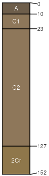
Samsil (35%)
Shallow Clay
Aridic Ustorthents
Well drained
Hydric: No
PAWS: 8 cm |
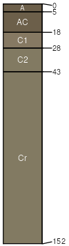
hillslopes / Shoulder hillslopes / Backslope
|
|
Samsil (25%)
Very Shallow
Aridic Ustorthents
Well drained
Hydric: No
PAWS: 6 cm |
hillslopes / Shoulder hillslopes / Backslope
|
|
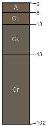
Badland (20%)
Non-site
Excessively drained
Hydric: No
PAWS: 6 cm |

hills / Summit hills / Shoulder
|
|
Grummit (5%)
Shallow Clay
Aridic Ustorthents
Well drained
Hydric: No
PAWS: 4 cm |
hills / Shoulder hills / Backslope
|
|
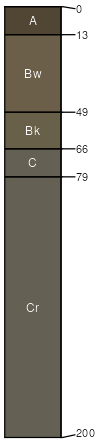
Pierre (5%)
Thin Upland
Torrertic Ustorthents
Well drained
Hydric: No
PAWS: 7 cm |
|
|
Fairburn (5%)
Thin Upland
Aridic Ustorthents
Well drained
Hydric: No
PAWS: 7 cm |
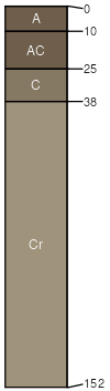
hills / Shoulder hills / Backslope
|
|
Vivian (5%)
Very Shallow
Aridic Ustorthents
Well drained
Hydric: No
PAWS: 14 cm |
ridges / Summit ridges / Shoulder ridges / Backslope
|
|