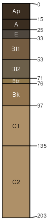
Hall silt loam, 0 to 1 percent slopes
Hall
(85%)
Loamy Lowland
Pachic Argiustolls
Well drained
Hydric: No
PAWS: 41 cm
stream terraces
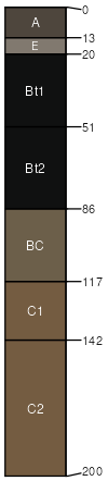
Scott
(5%)
Closed Upland Depression
Vertic Argialbolls
Poorly drained
Hydric: Yes
PAWS: 32 cm
playas / Toeslope
Wood River
(5%)
Saline Subirrigated
Typic Natrustolls
Moderately well drained
Hydric: No
PAWS: 38 cm
stream terraces
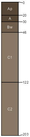
Cozad
(5%)
Loamy Lowland
Typic Haplustolls
Well drained
Hydric: No
PAWS: 42 cm
stream terraces
SSA
Scale
Published
Export
ne093
1:12,000
1968
2025-09-08