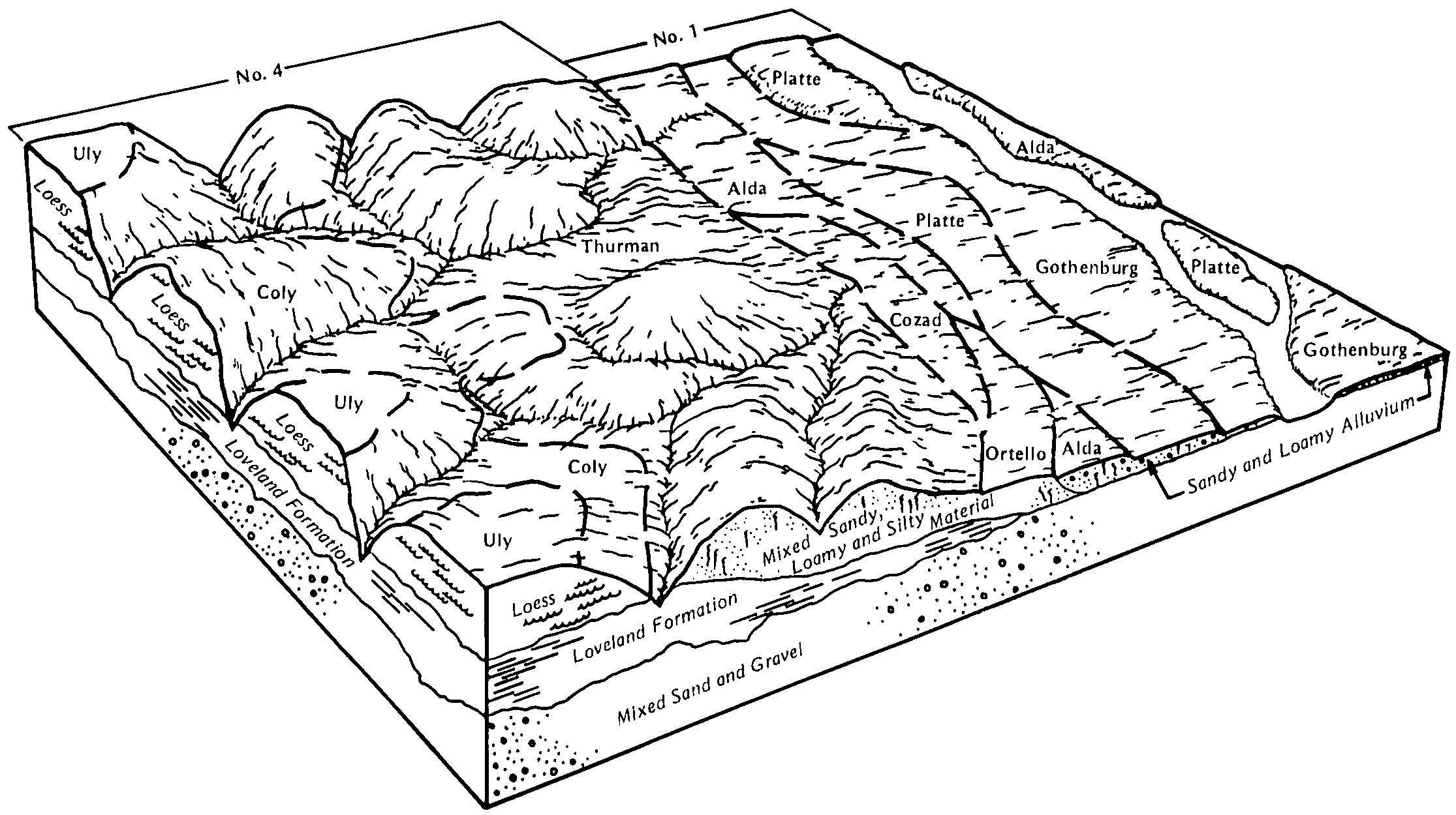
| Cozad silt loam, 2 to 5 percent slopes, rarely flooded | 2316 | 2517 | 1150754 | 3165f | ks137 | 1973 | 1:24000 |
Cozad silt loam, 0 to 2 percent slopes, rarely flooded | 2315 | 1944 | 1150753 | 3165d | ks137 | 1973 | 1:24000 |
Cozad silt loam, rarely flooded | 3715 | 6419 | 1382159 | 2ywss | ks169 | 1989 | 1:24000 |
Cozad silt loam, 0 to 1 percent slopes | 8815 | 1511 | 1691889 | 2tml6 | ne001 | 1970 | 1:20000 |
Cozad loam, sand substratum, 0 to 3 percent slopes | 8812 | 454 | 2216085 | 2dd0m | ne001 | 1970 | 1:20000 |
Cozad silt loam, 0 to 1 percent slopes | 8815 | 3747 | 426939 | gb87 | ne003 | 1975 | 1:20000 |
Cozad silt loam, 0 to 1 percent slopes | 8815 | 8394 | 1700039 | 2tml6 | ne019 | 1967 | 1:20000 |
Cozad silt loam, 6 to 11 percent slopes, eroded | 8819 | 1665 | 1700042 | 2tmkw | ne019 | 1967 | 1:20000 |
Cozad silt loam, 1 to 3 percent slopes | 8816 | 1655 | 1700040 | 30rst | ne019 | 1967 | 1:20000 |
Cozad silt loam, 3 to 6 percent slopes, eroded | 8818 | 1444 | 1700041 | 30rsv | ne019 | 1967 | 1:20000 |
Cozad fine sandy loam, calcareous variant, 0 to 1 percent slopes | 8824 | 473 | 1700021 | 30rsw | ne019 | 1967 | 1:20000 |
Cozad loam, 0 to 1 percent slopes | 8811 | 158 | 2228211 | 2dsms | ne019 | 1967 | 1:20000 |
Cozad silt loam, 1 to 3 percent slopes | 8816 | 2360 | 1691272 | 1trx5 | ne023 | 1979 | 1:20000 |
Cozad silt loam, 0 to 1 percent slopes | 8815 | 33 | 2219028 | 2tml6 | ne023 | 1979 | 1:20000 |
Cozad silt loam, 0 to 1 percent slopes | 8815 | 38043 | 1699580 | 2tml6 | ne041 | 1980 | 1:20000 |
Cozad silt loam, 1 to 3 percent slopes | 8816 | 20717 | 1699583 | 30rst | ne041 | 1980 | 1:20000 |
Cozad silt loam, 3 to 6 percent slopes | 8817 | 10393 | 1699581 | 2wtjn | ne041 | 1980 | 1:20000 |
Cozad silt loam, 0 to 1 percent slopes | 8815 | 81337 | 1699666 | 2tml6 | ne047 | 1975 | 1:20000 |
Cozad silt loam, 1 to 3 percent slopes | 8816 | 15120 | 1699667 | 30rst | ne047 | 1975 | 1:20000 |
Cozad fine sandy loam, 0 to 1 percent slopes | 8810 | 11610 | 1699665 | 31664 | ne047 | 1975 | 1:20000 |
Cozad silt loam, saline-alkali, 0 to 1 percent slopes | 8820 | 8495 | 1699670 | 1v1n2 | ne047 | 1975 | 1:20000 |
Cozad silt loam, 3 to 6 percent slopes | 8817 | 7499 | 1699668 | 2wtjn | ne047 | 1975 | 1:20000 |
Cozad silty clay loam, 0 to 1 percent slopes | 8821 | 4341 | 1699673 | 2tmkx | ne047 | 1975 | 1:20000 |
Cozad silt loam, 6 to 11 percent slopes, eroded | 8819 | 2675 | 1699669 | 2tmkw | ne047 | 1975 | 1:20000 |
Cozad silt loam, wet substratum, 1 to 3 percent slopes | 8828 | 694 | 1699672 | 1v1n4 | ne047 | 1975 | 1:20000 |
Cozad silt loam, wet substratum, 0 to 1 percent slopes | 8827 | 21 | 1699671 | 1v1n3 | ne047 | 1975 | 1:20000 |
Cozad silt loam, 1 to 3 percent slopes | 8816 | 1683 | 1699416 | 30rst | ne063 | 1973 | 1:20000 |
Cozad silt loam, rarely flooded | 3715 | 4 | 2219356 | 3165b | ne063 | 1973 | 1:20000 |
Cozad silt loam, 0 to 1 percent slopes | 8815 | 10737 | 1699736 | 31663 | ne065 | 1975 | 1:20000 |
Cozad silt loam, 1 to 3 percent slopes | 8816 | 3102 | 1699737 | 30rst | ne065 | 1975 | 1:20000 |
Cozad silt loam, 3 to 6 percent slopes | 8817 | 1235 | 1699738 | 2wtjn | ne065 | 1975 | 1:20000 |
Cozad silt loam, 0 to 1 percent slopes | 8815 | 3234 | 1699772 | 2tml6 | ne071 | 1984 | 1:20000 |
Cozad silt loam, 1 to 3 percent slopes | 8816 | 496 | 1699773 | 30rst | ne071 | 1984 | 1:20000 |
Cozad silt loam, rarely flooded | 3715 | 2057 | 1692202 | 3165b | ne073 | 1978 | 1:20000 |
Cozad silt loam, 1 to 3 percent slopes | 8816 | 1041 | 1692203 | 30rst | ne073 | 1978 | 1:20000 |
Cozad silt loam, 3 to 6 percent slopes | 8817 | 429 | 1692204 | 2wtjn | ne073 | 1978 | 1:20000 |
Cozad fine sandy loam, 0 to 1 percent slopes | 8810 | 243 | 2219497 | 31664 | ne073 | 1978 | 1:20000 |
Cozad silt loam, 0 to 1 percent slopes | 8815 | 13 | 2219495 | 2tml6 | ne073 | 1978 | 1:20000 |
Cozad silt loam, 0 to 1 percent slopes | 8815 | 2248 | 1699933 | 2tml6 | ne077 | 1987 | 1:20000 |
Cozad silt loam, 1 to 3 percent slopes | 8816 | 1002 | 1699934 | 30rst | ne077 | 1987 | 1:20000 |
Cozad silt loam, 3 to 6 percent slopes | 8817 | 30 | 2228881 | 2wtjn | ne077 | 1987 | 1:20000 |
Cozad loam, sand substratum, 0 to 3 percent slopes | 8812 | 5206 | 1700113 | 1v23c | ne079 | 2003 | 1:12000 |
Cozad loam, 0 to 1 percent slopes | 8811 | 2672 | 1700112 | 1v23b | ne079 | 2003 | 1:12000 |
Cozad, sand substratum-Hobbs, occasionally flooded, silt loams, 0 to 3 percent slopes | 8447 | 685 | 1700114 | 1v23d | ne079 | 2003 | 1:12000 |
Cozad silt loam, rarely flooded | 3715 | 1032 | 1692144 | 1tst9 | ne081 | 1982 | 1:20000 |
Cozad silt loam, wet substratum, rarely flooded | 8446 | 371 | 1692146 | 1tstc | ne081 | 1982 | 1:20000 |
Cozad silt loam, 1 to 3 percent slopes | 8816 | 258 | 1692145 | 1tstb | ne081 | 1982 | 1:20000 |
Cozad silt loam, 0 to 1 percent slopes | 8815 | 1280 | 1692236 | 31663 | ne083 | 1967 | 1:20000 |
Cozad silt loam, 1 to 3 percent slopes | 8816 | 148 | 1692237 | 30rst | ne083 | 1967 | 1:20000 |
Cozad silt loam, 3 to 6 percent slopes | 8817 | 67 | 1692238 | 2wtjn | ne083 | 1967 | 1:20000 |
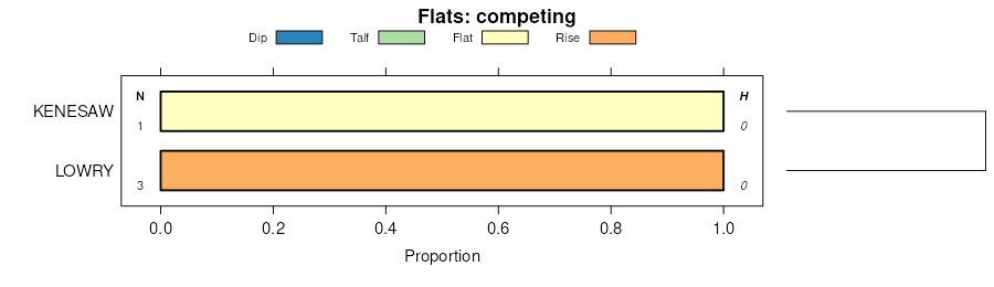
Kenesaw-Cozad complex | 9072 | 1808 | 99721 | 2wtjm | ne093 | 1968 | 1:12000 |
Cozad silt loam, 1 to 3 percent slopes | 8816 | 34 | 2228897 | 30rst | ne093 | 1968 | 1:12000 |
Cozad loam, sand substratum, 0 to 3 percent slopes | 8812 | 19 | 2228911 | 2dtcc | ne093 | 1968 | 1:12000 |
Cozad silt loam, 0 to 1 percent slopes | 8815 | 9425 | 1699152 | 2tml6 | ne111 | 1971 | 1:24000 |
Cozad silt loam, 1 to 3 percent slopes | 8816 | 4144 | 1699153 | 30rst | ne111 | 1971 | 1:24000 |
Cozad silt loam, saline-alkali, 0 to 1 percent slopes | 8820 | 3702 | 1699155 | 1v13g | ne111 | 1971 | 1:24000 |
Cozad silt loam, 3 to 6 percent slopes | 8817 | 1498 | 1699154 | 2wtjn | ne111 | 1971 | 1:24000 |
Cozad loam, sandy subsoil variant | 8813 | 954 | 1699158 | 31666 | ne111 | 1971 | 1:24000 |
Cozad silt loam, wet | 8826 | 815 | 1699156 | 1v13h | ne111 | 1971 | 1:24000 |
Cozad silty clay loam, 0 to 1 percent slopes | 8821 | 563 | 1699157 | 2tmkx | ne111 | 1971 | 1:24000 |
Cozad silt loam, 1 to 3 percent slopes | 8816 | 1821 | 1699524 | 30rst | ne115 | 1986 | 1:20000 |
Cozad silt loam, 0 to 1 percent slopes | 8815 | 1807 | 1699523 | 2tml6 | ne115 | 1986 | 1:20000 |
Cozad silt loam, 3 to 6 percent slopes | 8817 | 10 | 2219818 | 2wtjn | ne115 | 1986 | 1:20000 |
Cozad loam, wet substratum, 0 to 1 percent slopes | 8814 | 6335 | 1709629 | 1vd0b | ne121 | 1978 | 1:20000 |
Cozad loam, sand substratum, 0 to 3 percent slopes | 8812 | 209 | 2228265 | 2dspj | ne121 | 1978 | 1:20000 |
Kenesaw-Cozad complex | 9072 | 14 | 2228286 | 2wtjm | ne121 | 1978 | 1:20000 |
Cozad silt loam, 0 to 1 percent slopes | 8815 | 1857 | 1692049 | 31665 | ne129 | 1974 | 1:20000 |
Cozad silt loam, 0 to 1 percent slopes | 8815 | 1126 | 1691733 | 2tml6 | ne137 | 1967 | 1:20000 |
Cozad silt loam, rarely flooded | 3715 | 216 | 2219472 | 3165b | ne137 | 1967 | 1:20000 |
Cozad silt loam, 0 to 1 percent slopes | 8815 | 2120 | 1692268 | 2tml6 | ne143 | 1967 | 1:20000 |
Cozad-variant complex | 8825 | 866 | 1692286 | 1tsyw | ne143 | 1967 | 1:20000 |
Cozad silt loam, 1 to 3 percent slopes | 8816 | 865 | 1692269 | 1tsyb | ne143 | 1967 | 1:20000 |
Cozad silt loam, 3 to 6 percent slopes | 8817 | 417 | 1692270 | 2wtjn | ne143 | 1967 | 1:20000 |
Cozad silt loam, 1 to 3 percent slopes | 8816 | 6334 | 1699446 | 30rst | ne145 | 1965 | 1:20000 |
Cozad silt loam, 0 to 1 percent slopes | 8815 | 4911 | 1699445 | 31663 | ne145 | 1965 | 1:20000 |
Cozad silt loam, 3 to 6 percent slopes | 8817 | 1580 | 1699447 | 2wtjn | ne145 | 1965 | 1:20000 |
Cozad silt loam, 0 to 1 percent slopes | 8815 | 3725 | 1699985 | 2tml6 | ne163 | 1987 | 1:20000 |
Cozad silt loam, 1 to 3 percent slopes | 8816 | 3573 | 1699986 | 30rst | ne163 | 1987 | 1:20000 |
Cozad silt loam, 0 to 1 percent slopes | 8815 | 11830 | 1699878 | 2tml6 | ne175 | 1983 | 1:20000 |
Cozad silt loam, 1 to 3 percent slopes | 8816 | 9970 | 1699879 | 30rst | ne175 | 1983 | 1:20000 |
Cozad silt loam, 3 to 6 percent slopes | 8817 | 2616 | 1699880 | 2wtjn | ne175 | 1983 | 1:20000 |
