Bangtail (35%)
Upland Grassland Group
Ustic Argicryolls
Well drained
Hydric: No
PAWS: 14 cm |
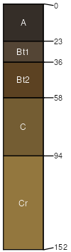
mountain slopes / Backslope
|
|
Woodhall (25%)
Upland Shrubland Group
Ustic Argicryolls
Well drained
Hydric: No
PAWS: 8 cm |
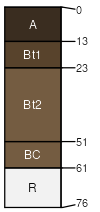
mountain slopes / Shoulder mountain slopes / Backslope
|
|
Dalys (20%)
Shallow Shrubland Group
Lithic Haplocryolls
Well drained
Hydric: No
PAWS: 2 cm |
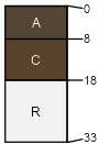
mountain slopes / Shoulder mountain slopes / Backslope
|
|
Tophat (10%)
Pachic Argicryolls
Well drained
Hydric: No
PAWS: 21 cm |
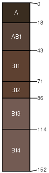
draws / Backslope draws / Footslope mountain slopes
|
|
Rock outcrop (10%)
Hydric:
PAWS: NA |

|
|