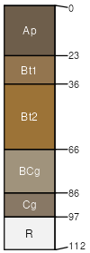
Blairton channery silt loam, 8 to 15 percent slopes
Blairton
(80%)
Mixed Sedimentary Upland
Convergent Uplands
Aquic Hapludults
Moderately well drained
Hydric: No
PAWS: 9 cm
depressions / Summit
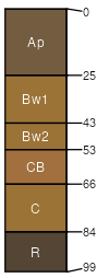
Weikert
(10%)
Lithic Dystrudepts
Well drained
Hydric: No
PAWS: 3 cm
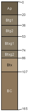
Brinkerton
(5%)
Typic Fragiaqualfs
Poorly drained
Hydric: Yes
PAWS: 23 cm
depressions / Toeslope
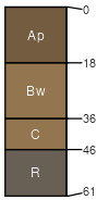
Berks
(5%)
Typic Dystrudepts
Well drained
Hydric: No
PAWS: 7 cm
SSA
Scale
Published
Export
pa009
1:24,000
1989
2025-09-05