| Berks, Muskingum, and Weikert soils, 35 to 70 percent slopes | 793G | 3757 | 1402114 | 1j20h | il087 | 2005 | 1:12000 |
Berks, Muskingum, and Weikert soils, 18 to 35 percent slopes | 793F | 1251 | 1402113 | 1j20g | il087 | 2005 | 1:12000 |
Berks, Muskingum, and Weikert soils, 18 to 35 percent slopes | 793F | 2790 | 1478043 | 1lm0t | il199 | 2007 | 1:12000 |
Berks, Muskingum, and Weikert soils, 35 to 70 percent slopes | 793G | 492 | 1478044 | 1lm0v | il199 | 2007 | 1:12000 |
Weikert-rock outcrop complex, 35 to 80 percent slopes | WfG | 966 | 163081 | 5gpp | in107 | 1984 | 1:15840 |
Weikert channery silt loam, 40 to 80 percent slopes | WcG | 1228 | 163260 | 5gwg | in109 | 1979 | 1:15840 |
Weikert silt loam, 25 to 70 percent slopes | WeG | 2286 | 159863 | 5cbw | in133 | 1979 | 1:15840 |
Weikert Variant fine sandy loam, 35 to 80 percent slopes, very bouldery | WpG | 854 | 163184 | 5gt0 | in171 | 1987 | 1:15840 |
Weikert-Culleoka complex, 6 to 12 percent slopes | WcC | 7454 | 1592487 | 1qg3k | ky001 | 2006 | 1:12000 |
Weikert-Culleoka complex, 12 to 20 percent slopes | WcD | 6780 | 1592488 | 1qg3l | ky001 | 2006 | 1:12000 |
Culleoka-Weikert complex, 2 to 6 percent slopes | CwB | 1502 | 1592486 | 1qg3j | ky001 | 2006 | 1:12000 |
Urban land-Weikert-Culleoka complex, 2 to 20 percent slopes | Uw | 1466 | 1413379 | 1jfqw | ky001 | 2006 | 1:12000 |
Frondorf-Weikert complex, 20 to 40 percent slopes | FwF | 33108 | 549057 | lfbj | ky047 | 1977 | 1:20000 |
Frondorf-Weikert complex, 12 to 20 percent slopes | FwD | 17697 | 549056 | lfbh | ky047 | 1977 | 1:20000 |
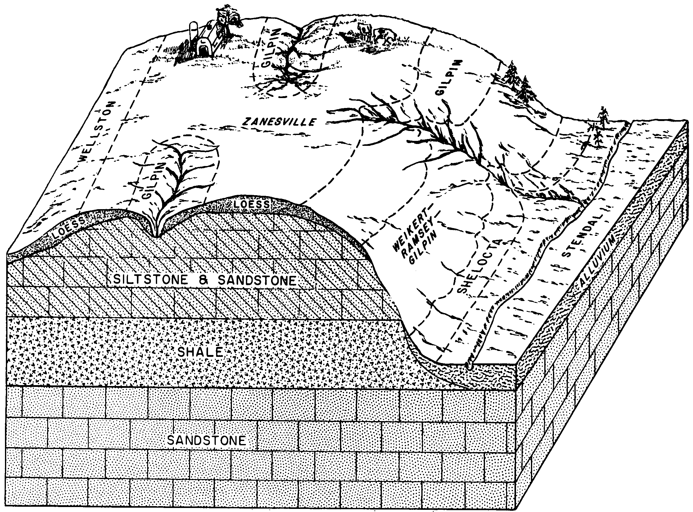
Weikert-Ramsey-Gilpin stony complex, 20 to 30 percent slopes | WgE | 20385 | 549693 | lg01 | ky085 | 1967 | 1:20000 |
Weikert-Ramsey-Gilpin stony complex, 30 to 50 percent slopes | WgF | 17290 | 549695 | lg03 | ky085 | 1967 | 1:20000 |
Weikert channery silt loam, 12 to 30 percent slopes | WcE | 12080 | 549691 | lfzz | ky085 | 1967 | 1:20000 |
Weikert-Ramsey-Gilpin stony complex, 20 to 30 percent slopes, severely eroded | WgE3 | 5020 | 549694 | lg02 | ky085 | 1967 | 1:20000 |
Weikert channery silt loam, 12 to 30 percent slopes, severely eroded | WcE3 | 3870 | 549692 | lg00 | ky085 | 1967 | 1:20000 |
Gilpin-Weikert complex, 25 to 60 percent slopes | GwF | 1337 | 1533074 | 1ng90 | ky111 | 2005 | 1:12000 |
Weikert channery silt loam, 40 to 80 percent slopes | WeG | 7224 | 1397927 | 1hxnf | ky151 | 1968 | 1:20000 |
Rockcastle-Weikert complex, 20 to 50 percent slopes | RlF | 13965 | 549996 | lg9t | ky179 | 1967 | 1:15840 |
Frondorf-Weikert complex, 20 to 45 percent slopes | FwF | 16020 | 551160 | lhjc | ky219 | 1984 | 1:20000 |
Frondorf-Weikert complex, 12 to 20 percent slopes | FwD | 8320 | 551159 | lhjb | ky219 | 1984 | 1:20000 |
Weikert channery silt loam, 40 to 80 percent slopes | WcF | 16524 | 552307 | ljqc | ky628 | 1973 | 1:20000 |
Frondorf-Weikert-Wellston complex, 12 to 20 percent slopes | FwD | 690 | 549461 | lfrk | ky629 | 1979 | 1:20000 |
Frondorf-Weikert-Wellston complex, 6 to 12 percent slopes | FwC | 380 | 549460 | lfrj | ky629 | 1979 | 1:20000 |
Frondorf-Weikert-Wellston complex, 20 to 50 percent slopes | FwF | 170 | 549462 | lfrl | ky629 | 1979 | 1:20000 |
Weikert and Ramsey stony soils, 20 to 50 percent slopes | WrE | 1696 | 2453022 | 2nbkr | ky646 | 1966 | 1:15840 |
Weikert and Ramsey stony soils, 12 to 20 percent slopes | WrD | 577 | 2453021 | 2nbkq | ky646 | 1966 | 1:15840 |
Frondorf-Weikert complex, 20 to 50 percent slopes | FwF | 554 | 2452865 | 2nbdp | ky709 | 1995 | 1:20000 |
Weikert channery silt loam, 25 to 45 percent slopes | WeE | 27400 | 2401258 | 2w6my | md001 | 2009 | 1:12000 |
Weikert channery silt loam, 15 to 25 percent slopes | WeD | 15103 | 2401257 | 2v4vs | md001 | 2009 | 1:12000 |
Weikert channery silt loam, 8 to 15 percent slopes | WeC | 6288 | 2401256 | 2v4w5 | md001 | 2009 | 1:12000 |
Weikert channery silt loam, 25 to 45 percent slopes, very flaggy | WfE | 6066 | 2401262 | 2wkdf | md001 | 2009 | 1:12000 |
Weikert-Rock outcrop complex, 45 to 65 percent slopes | WgF | 3154 | 2401269 | 2llq9 | md001 | 2009 | 1:12000 |
Weikert very flaggy silt loam, 45 to 65 percent slopes | WfF | 2212 | 2401263 | 2llq3 | md001 | 2009 | 1:12000 |
Weikert channery silt loam, 45 to 65 percent slopes | WeF | 1886 | 2401259 | 2llpz | md001 | 2009 | 1:12000 |
Weikert very flaggy silt loam, 15 to 25 percent slopes | WfD | 1645 | 2401261 | 2llq1 | md001 | 2009 | 1:12000 |
Weikert channery silt loam, 3 to 8 percent slopes | WeB | 1497 | 2401255 | 2v4vr | md001 | 2009 | 1:12000 |
Weikert-Rock outcrop complex, 25 to 45 percent slopes | WgE | 899 | 2401268 | 2llq8 | md001 | 2009 | 1:12000 |
Weikert very flaggy silt loam, 8 to 15 percent slopes | WfC | 445 | 2401260 | 2llq0 | md001 | 2009 | 1:12000 |
Weikert-Urban land complex, 15 to 25 percent slopes | WkD | 159 | 2401056 | 2llhf | md001 | 2009 | 1:12000 |
Weikert-Rock outcrop complex, 15 to 25 percent slopes | WgD | 152 | 2401267 | 2llq7 | md001 | 2009 | 1:12000 |
Weikert very channery silt loam, 25 to 65 percent slopes | WeF | 6587 | 534731 | 2wkdk | md043 | 1998 | 1:12000 |
Weikert very channery silt loam, 15 to 25 percent slopes | WeD | 3220 | 534730 | 2v4vy | md043 | 1998 | 1:12000 |
Weikert very channery silt loam, 8 to 15 percent slopes | WeC | 3177 | 534729 | 2v4vx | md043 | 1998 | 1:12000 |
Weikert-Berks channery silt loams, 15 to 25 percent slopes | WkD | 1610 | 534741 | 2v4w1 | md043 | 1998 | 1:12000 |
Weikert-Berks channery silt loams, 8 to 15 percent slopes | WkC | 1596 | 534740 | 2v4w0 | md043 | 1998 | 1:12000 |
Weikert very channery silt loam, 3 to 8 percent slopes | WeB | 1248 | 534728 | 2v4vw | md043 | 1998 | 1:12000 |
Weikert-Berks channery silt loams, 3 to 8 percent slopes | WkB | 1149 | 534739 | 2v4vz | md043 | 1998 | 1:12000 |
Berks-Weikert channery silt loams, 8 to 15 percent slopes | BfC | 534 | 534157 | 2sgdb | md043 | 1998 | 1:12000 |
Berks-Weikert channery silt loams, 3 to 8 percent slopes | BfB | 388 | 534156 | 2sgd9 | md043 | 1998 | 1:12000 |
Berks-Weikert-Urban land complex, 8 to 25 percent slopes | BkD | 237 | 534166 | 2y18g | md043 | 1998 | 1:12000 |
Berks-Weikert-Urban land complex, 0 to 8 percent slopes | BkB | 56 | 534161 | 2y18h | md043 | 1998 | 1:12000 |
Shelocta-Cruze-Weikert association, steep | SgE | 77 | 1420562 | 1jp6l | oh071 | 1973 | 1:15840 |
Weikert shaly silt loam, 35 to 70 percent slopes | WkF | 379 | 171175 | 5r3s | oh091 | 1977 | 1:15840 |
Weikert channery fine sandy loam, 1 to 6 percent slopes | WeB | 344 | 287821 | 9nhk | oh093 | 1972 | 1:15840 |
Gilpin-Weikert complex, 25 to 70 percent slopes | GsF | 10 | 1650887 | 1sdwf | oh099 | 1966 | 1:15840 |
Shelocta-Cruze-Weikert association, steep | SgE | 828 | 1689017 | 1tpkf | oh131 | 1984 | 1:15840 |
Shelocta-Cruze-Weikert association, steep | ShE | 33970 | 170960 | 5qwv | oh141 | 1997 | 1:15840 |
Weikert channery silt loam, 25 to 50 percent slopes, moderately eroded | WeF2 | 1158 | 288102 | 9nsm | oh151 | 1967 | 1:15840 |
Weikert channery silt loam, 18 to 25 percent slopes, moderately eroded | WeE2 | 482 | 288101 | 9nsl | oh151 | 1967 | 1:15840 |
Weikert channery silt loam, 12 to 18 percent slopes | WeD | 211 | 288100 | 9nsk | oh151 | 1967 | 1:15840 |
Weikert channery silt loam, 6 to 12 percent slopes | WeC | 137 | 288099 | 9nsj | oh151 | 1967 | 1:15840 |
Gilpin, Weikert, Culleoka channery silt loams and 25 to 80 percent slopes | GSF | 47074 | 541687 | 2wds4 | pa003 | 1973 | 1:15840 |
Culleoka-Weikert shaly silt loams, 15 to 25 percent slopes | CwD | 2581 | 541672 | l5n9 | pa003 | 1973 | 1:15840 |
Culleoka-Weikert shaly silt loams, 8 to 15 percent slopes | CwC | 1307 | 541671 | l5n8 | pa003 | 1973 | 1:15840 |
Weikert-Rock outcrop complex, 25 to 80 percent slopes | WEF | 1062 | 541734 | 2wdrz | pa003 | 1973 | 1:15840 |
Culleoka-Weikert shaly silt loams, 3 to 8 percent slopes | CwB | 757 | 541670 | l5n7 | pa003 | 1973 | 1:15840 |
Gilpin-Weikert channery silt loams, 25 to 70 percent slopes | GwF | 111885 | 2422487 | 2wds3 | pa005 | 2012 | 1:24000 |
Gilpin-Weikert channery silt loams, 15 to 25 percent slopes | GwD | 38709 | 2422490 | 2wds2 | pa005 | 2012 | 1:24000 |
Gilpin-Weikert channery silt loams, 8 to 15 percent slopes | GwC | 7348 | 2422489 | 2wds1 | pa005 | 2012 | 1:24000 |
Gilpin-Weikert channery silt loams, 3 to 8 percent slopes | GwB | 6737 | 2422488 | 2wds0 | pa005 | 2012 | 1:24000 |
Weikert channery silt loam, 3 to 8 percent slopes | WeB | 2746 | 1678247 | 2wdrx | pa005 | 2012 | 1:24000 |
Weikert channery silt loam, 8 to 15 percent slopes | WeC | 1427 | 1678248 | 2wdry | pa005 | 2012 | 1:24000 |
Gilpin-Weikert channery silt loams, 25 to 70 percent slopes | GsF | 50731 | 2900276 | 2wds3 | pa007 | 1978 | 1:15840 |
Gilpin-Weikert channery silt loams, 15 to 25 percent slopes | GsD | 13065 | 2900275 | 2wds2 | pa007 | 1978 | 1:15840 |
Gilpin-Weikert channery silt loams, 8 to 15 percent slopes | GsC | 6309 | 2900274 | 2wds1 | pa007 | 1978 | 1:15840 |
Weikert-Rock outcrop complex, 25 to 80 percent slopes | WeF | 4964 | 2900321 | 2wdrz | pa007 | 1978 | 1:15840 |
Gilpin-Weikert channery silt loams, 3 to 8 percent slopes | GsB | 2100 | 2900273 | 2wds0 | pa007 | 1978 | 1:15840 |
Weikert channery silt loam, 35 to 65 percent slopes | WkF | 24964 | 541862 | 2v4wb | pa009 | 1989 | 1:24000 |
Weikert channery silt loam, 25 to 35 percent slopes | WkE | 13942 | 541861 | l5vd | pa009 | 1989 | 1:24000 |
Weikert channery silt loam, 8 to 15 percent slopes | WkC | 8484 | 541859 | 2v4w5 | pa009 | 1989 | 1:24000 |
Weikert channery silt loam, 15 to 25 percent slopes | WkD | 7848 | 541860 | 2v4vs | pa009 | 1989 | 1:24000 |
Weikert very flaggy silt loam, 25 to 60 percent slopes | WlF | 1852 | 541863 | l5vg | pa009 | 1989 | 1:24000 |
Berks-Weikert complex, 8 to 15 percent slopes | BkC | 57625 | 542978 | 2sgbj | pa011 | 1997 | 1:24000 |
Berks-Weikert complex, 3 to 8 percent slopes | BkB | 29139 | 542977 | 2sgbh | pa011 | 1997 | 1:24000 |
Weikert-Berks complex, 15 to 25 percent slopes | WeD | 16153 | 543096 | 2v4w3 | pa011 | 1997 | 1:24000 |
Berks-Weikert complex, 25 to 60 percent slopes | BkF | 15099 | 542980 | 2sgcr | pa011 | 1997 | 1:24000 |
Berks-Weikert complex, 15 to 25 percent slopes | BkD | 11351 | 542979 | 2wkdr | pa011 | 1997 | 1:24000 |
Weikert-Berks complex, 3 to 8 percent slopes | WeB | 5134 | 543095 | 2v4w4 | pa011 | 1997 | 1:24000 |
Berks-Weikert complex, 0 to 3 percent slopes | BkA | 705 | 542976 | 2sgbf | pa011 | 1997 | 1:24000 |
Berks-Weikert channery silt loams, 25 to 70 percent slopes | BmF | 18313 | 542326 | 2sgct | pa013 | 1978 | 1:20000 |
Weikert channery silt loam, 15 to 25 percent slopes | WeD | 3116 | 542419 | 2v4vs | pa013 | 1978 | 1:20000 |
Weikert channery silt loam, 8 to 15 percent slopes | WeC | 2009 | 542418 | 2v4w5 | pa013 | 1978 | 1:20000 |
Weikert channery silt loam, 3 to 8 percent slopes | WeB | 1247 | 542417 | 2v4vr | pa013 | 1978 | 1:20000 |
Berks-Weikert channery silt loams, 15 to 25 percent slopes | BmD | 1171 | 542325 | 2sgbp | pa013 | 1978 | 1:20000 |
Berks-Weikert channery silt loams, 8 to 15 percent slopes | BmC | 957 | 542324 | 2sgbn | pa013 | 1978 | 1:20000 |
Edom-Weikert complex, 8 to 15 percent slopes | EmC | 736 | 542346 | l6c1 | pa013 | 1978 | 1:20000 |
Edom-Weikert complex, 15 to 25 percent slopes | EmD | 667 | 542347 | l6c2 | pa013 | 1978 | 1:20000 |
Edom-Weikert complex, 3 to 8 percent slopes | EmB | 284 | 542345 | l6c0 | pa013 | 1978 | 1:20000 |
Culleoka-Weikert channery silt loams, 8 to 15 percent slopes | CyC | 1663 | 543622 | l7p6 | pa017 | 1997 | 1:24000 |
Culleoka-Weikert channery silt loams, 3 to 8 percent slopes | CyB | 1208 | 543621 | l7p5 | pa017 | 1997 | 1:24000 |
Weikert-Culleoka complex, 15 to 25 percent slopes | WfD | 706 | 543761 | l7tp | pa017 | 1997 | 1:24000 |
Weikert channery silt loam, 8 to 15 percent slopes | WeC | 64 | 543759 | l7tm | pa017 | 1997 | 1:24000 |
Weikert channery silt loam, 0 to 8 percent slopes | WeB | 25 | 543758 | l7tl | pa017 | 1997 | 1:24000 |
Weikert channery silt loam, 15 to 25 percent slopes | WeD | 14 | 543760 | l7tn | pa017 | 1997 | 1:24000 |
Gilpin-Weikert channery silt loams, 25 to 70 percent slopes | GoF | 12234 | 538185 | 2wds3 | pa019 | 1984 | 1:15840 |
Gilpin-Weikert channery silt loams, 15 to 25 percent slopes | GoD | 11357 | 538184 | 2wds2 | pa019 | 1984 | 1:15840 |
Gilpin-Weikert channery silt loams, 8 to 15 percent slopes | GoC | 7040 | 538183 | 2wds1 | pa019 | 1984 | 1:15840 |
Gilpin-Weikert channery silt loams, 3 to 8 percent slopes | GoB | 5971 | 538182 | 2wds0 | pa019 | 1984 | 1:15840 |
Gilpin-Weikert channery silt loams, 25 to 70 percent slopes | GWF | 8543 | 541910 | l5wz | pa021 | 1978 | 1:20000 |
Gilpin-Weikert channery silt loams, 8 to 15 percent slopes | GwC | 3584 | 541917 | l5x6 | pa021 | 1978 | 1:20000 |
Gilpin-Weikert channery silt loams, 15 to 25 percent slopes | GwD | 3471 | 541918 | l5x7 | pa021 | 1978 | 1:20000 |
Gilpin-Weikert channery silt loams, 3 to 8 percent slopes | GwB | 2671 | 541916 | l5x5 | pa021 | 1978 | 1:20000 |
Berks-Weikert channery silt loam, 8 to 15 percent slopes | BwC | 8088 | 3098650 | 2y0qm | pa025 | 1960 | 1:20000 |
Berks-Weikert channery silt loam, 3 to 8 percent slopes | BwB | 6445 | 3098649 | 2y0ql | pa025 | 1960 | 1:20000 |
Berks-Weikert channery silt loam, 15 to 25 percent slopes | BwD | 6102 | 3098651 | 2y0qn | pa025 | 1960 | 1:20000 |
Weikert-Berks channery silt loam, 25 to 35 percent slopes | WbE | 4472 | 3098653 | 2y0qq | pa025 | 1960 | 1:20000 |
Weikert-Berks channery silt loam, 35 to 100 percent slopes, very rocky | WbF | 2586 | 3098654 | 2y0qr | pa025 | 1960 | 1:20000 |
Berks-Weikert channery silt loam, 0 to 3 percent slopes | BwA | 640 | 3098648 | 2y0qk | pa025 | 1960 | 1:20000 |
Berks-Weikert channery silt loam, 15 to 25 percent slopes, rocky | BxD | 166 | 3098652 | 2y0qp | pa025 | 1960 | 1:20000 |
Berks and Weikert soils, 25 to 70 percent slopes | BMF | 28277 | 538243 | 2xtjn | pa027 | 1975 | 1:20000 |
Weikert shaly silt loam, 5 to 15 percent slopes | WeC | 2556 | 538356 | l26b | pa027 | 1975 | 1:20000 |
Weikert channery silt loam, 15 to 25 percent slopes | WeD | 1736 | 538357 | 2v4vs | pa027 | 1975 | 1:20000 |
Gilpin-Weikert channery silt loams, 25 to 70 percent slopes | GwF | 10240 | 563496 | 2wds3 | pa031 | 2012 | 1:24000 |
Gilpin-Weikert channery silt loams, 8 to 15 percent slopes | GwC | 4963 | 529760 | 2wds1 | pa031 | 2012 | 1:24000 |
Gilpin-Weikert channery silt loams, 3 to 8 percent slopes | GwB | 1903 | 529759 | 2wds0 | pa031 | 2012 | 1:24000 |
Berks-Weikert complex, 25 to 60 percent slopes | BeE | 9916 | 543893 | l7yy | pa035 | 2002 | 1:24000 |
Berks-Weikert complex, 15 to 25 percent slopes | BeD | 5736 | 543891 | l7yw | pa035 | 2002 | 1:24000 |
Weikert channery silt loam, 35 to 80 percent slopes, moderately eroded | WcF2 | 15423 | 539570 | 2w6n9 | pa037 | 1965 | 1:20000 |
Weikert channery silt loam, 20 to 35 percent slopes, moderately eroded | WcD2 | 14937 | 539569 | 2w6nc | pa037 | 1965 | 1:20000 |
Weikert channery silt loam, 12 to 20 percent slopes, moderately eroded | WcC2 | 8720 | 539568 | 2wkc4 | pa037 | 1965 | 1:20000 |
Weikert channery silt loam, 3 to 12 percent slopes, moderately eroded | WcB2 | 8442 | 539567 | 2wkc3 | pa037 | 1965 | 1:20000 |
Weikert very stony silt loam, 35 to 80 percent slopes | WeF | 2301 | 539572 | l3gk | pa037 | 1965 | 1:20000 |
Litz and Weikert shaly silt loams, 20 to 35 percent slopes, severely eroded | LrD3 | 727 | 539525 | l3f1 | pa037 | 1965 | 1:20000 |
Litz and Weikert shaly silt loams, 35 to 50 percent slopes, moderately eroded | LrE2 | 595 | 539526 | l3f2 | pa037 | 1965 | 1:20000 |
Weikert very stony silt loam, 12 to 35 percent slopes | WeD | 294 | 539571 | l3gj | pa037 | 1965 | 1:20000 |
Litz and Weikert shaly silt loams, 12 to 20 percent slopes, severely eroded | LrC3 | 290 | 539524 | l3f0 | pa037 | 1965 | 1:20000 |
Weikert very channery silt loam, 8 to 15 percent slopes | WeC | 8067 | 693798 | 2v4vx | pa041 | 1980 | 1:15840 |
Weikert very channery silt loam, 15 to 25 percent slopes | WeD | 7163 | 693799 | 2v4vy | pa041 | 1980 | 1:15840 |
Weikert and Klinesville very shaly silt loams, 25 to 75 percent slopes | WkF | 5512 | 693800 | r8yn | pa041 | 1980 | 1:15840 |
Weikert very channery silt loam, 3 to 8 percent slopes | WeB | 2249 | 693797 | 2v4vw | pa041 | 1980 | 1:15840 |
Weikert shaly silt loam, 25 to 40 percent slopes, moderately eroded | WeE2 | 4221 | 540777 | l4qf | pa043 | 1967 | 1:15840 |
Weikert shaly silt loam, 15 to 25 percent slopes, moderately eroded | WeD2 | 616 | 540776 | l4qd | pa043 | 1967 | 1:15840 |
Weikert shaly silt loam, 5 to 15 percent slopes, moderately eroded | WeC2 | 598 | 540775 | l4qc | pa043 | 1967 | 1:15840 |
Gilpin-Weikert channery silt loams, 25 to 70 percent slopes | GwF | 14150 | 1591087 | 2wds3 | pa051 | 2005 | 1:24000 |
Gilpin-Weikert channery silt loams, 15 to 25 percent slopes | GwD | 811 | 1591086 | 2wds2 | pa051 | 2005 | 1:24000 |
Gilpin-Weikert channery silt loams, 8 to 15 percent slopes | GwC | 320 | 1591085 | 2wds1 | pa051 | 2005 | 1:24000 |
Gilpin-Weikert channery silt loams, 3 to 8 percent slopes | GwB | 261 | 1591084 | 2wds0 | pa051 | 2005 | 1:24000 |
Weikert channery silt loam, 3 to 8 percent slopes | WeB | 13084 | 545231 | 2v4vr | pa055 | 1999 | 1:24000 |
Weikert channery silt loam, 8 to 15 percent slopes | WeC | 12281 | 545232 | 2v4w5 | pa055 | 1999 | 1:24000 |
Weikert very channery silt loam, 25 to 65 percent slopes | WkF | 9777 | 545230 | 2wkdk | pa055 | 1999 | 1:24000 |
Weikert channery silt loam, 15 to 25 percent slopes | WeD | 8490 | 545233 | 2v4vs | pa055 | 1999 | 1:24000 |
Weikert very channery silt loam, 8 to 15 percent slopes | WkC | 7594 | 545226 | 2v4vx | pa055 | 1999 | 1:24000 |
Weikert very channery silt loam, 15 to 25 percent slopes | WkD | 6109 | 545228 | 2v4vy | pa055 | 1999 | 1:24000 |
Weikert very channery silt loam, 3 to 8 percent slopes | WkB | 3125 | 545224 | 2v4vw | pa055 | 1999 | 1:24000 |
Klinesville and Weikert soils, 25 to 60 percent slopes | KWF | 42177 | 544886 | l8zz | pa057 | 1999 | 1:24000 |
Weikert channery silt loam, 8 to 15 percent slopes | WeC | 9385 | 544947 | 2v4w5 | pa057 | 1999 | 1:24000 |
Weikert channery silt loam, 15 to 25 percent slopes | WeD | 6620 | 544948 | 2v4vs | pa057 | 1999 | 1:24000 |
Weikert channery silt loam, 3 to 8 percent slopes | WeB | 1377 | 544946 | 2v4vr | pa057 | 1999 | 1:24000 |
Berks-Weikert association, steep | BMF | 64573 | 541954 | 2sgbs | pa061 | 1974 | 1:20000 |
Berks-Weikert channery silt loams, 15 to 25 percent slopes | BlD | 20927 | 541963 | 2sgbp | pa061 | 1974 | 1:20000 |
Edom-Weikert complex, 15 to 25 percent slopes | EgD | 10868 | 541987 | l5zg | pa061 | 1974 | 1:20000 |
Edom-Weikert complex, 8 to 15 percent slopes | EgC | 8816 | 541986 | l5zf | pa061 | 1974 | 1:20000 |
Weikert channery silt loam, 15 to 25 percent slopes | WeD | 8800 | 542047 | 2v4vs | pa061 | 1974 | 1:20000 |
Edom-Weikert complex, 25 to 60 percent slopes | EgF | 5287 | 541988 | l5zh | pa061 | 1974 | 1:20000 |
Weikert channery silt loam, 8 to 15 percent slopes | WeC | 3242 | 542046 | 2v4w5 | pa061 | 1974 | 1:20000 |
Edom-Weikert complex, 3 to 8 percent slopes | EgB | 2386 | 541985 | l5zd | pa061 | 1974 | 1:20000 |
Weikert channery silt loam, 3 to 8 percent slopes | WeB | 811 | 542045 | 2v4vr | pa061 | 1974 | 1:20000 |
Gilpin-Weikert channery silt loams, 15 to 25 percent slopes | GwD | 28094 | 1720929 | 2wds2 | pa063 | 2012 | 1:24000 |
Gilpin-Weikert channery silt loams, 25 to 70 percent slopes | GwF | 18373 | 1720931 | 2wds3 | pa063 | 2012 | 1:24000 |
Gilpin-Weikert channery silt loams, 8 to 15 percent slopes | GwC | 12256 | 1720928 | 2wds1 | pa063 | 2012 | 1:24000 |
Gilpin-Weikert channery silt loams, 3 to 8 percent slopes | GwB | 2678 | 1720927 | 2wds0 | pa063 | 2012 | 1:24000 |
Gilpin-Weikert channery silt loams, 25 to 100 percent slopes, very stony | GxF | 1905 | 1720886 | 1vrqg | pa063 | 2012 | 1:24000 |
Gilpin-Weikert channery silt loams, 25 to 70 percent slopes | GwF | 7168 | 2398972 | 2wds3 | pa065 | 2012 | 1:12000 |
Gilpin-Weikert channery silt loams, 15 to 25 percent slopes | GwD | 3948 | 2398971 | 2wds2 | pa065 | 2012 | 1:12000 |
Gilpin-Weikert channery silt loams, 3 to 8 percent slopes | GwB | 1955 | 2398969 | 2wds0 | pa065 | 2012 | 1:12000 |
Gilpin-Weikert channery silt loams, 8 to 15 percent slopes | GwC | 1820 | 2398970 | 2wds1 | pa065 | 2012 | 1:12000 |
Gilpin-Weikert channery silt loams, 25 to 70 percent slopes | GsF | 4951 | 2900428 | 2wds3 | pa073 | 1978 | 1:15840 |
Weikert-Rock outcrop complex, 25 to 80 percent slopes | WeF | 2515 | 2900473 | 2wdrz | pa073 | 1978 | 1:15840 |
Gilpin-Weikert channery silt loams, 15 to 25 percent slopes | GsD | 778 | 2900427 | 2wds2 | pa073 | 1978 | 1:15840 |
Gilpin-Weikert channery silt loams, 8 to 15 percent slopes | GsC | 141 | 2900426 | 2wds1 | pa073 | 1978 | 1:15840 |
Gilpin-Weikert channery silt loams, 3 to 8 percent slopes | GsB | 63 | 2900425 | 2wds0 | pa073 | 1978 | 1:15840 |
Weikert channery silt loam, 15 to 25 percent slopes | WeD | 3594 | 2871297 | 2v4vs | pa075 | 1976 | 1:20000 |
Weikert channery silt loam, 3 to 8 percent slopes | WeB | 2955 | 2871266 | 2v4vr | pa075 | 1976 | 1:20000 |
Weikert shaly silt loam, 25 to 50 percent slopes | WeE | 2408 | 541346 | l59s | pa075 | 1976 | 1:20000 |
Weikert channery silt loam, 8 to 15 percent slopes | WeC | 2128 | 2871280 | 2v4w5 | pa075 | 1976 | 1:20000 |
Berks-Weikert complex, 3 to 8 percent slopes | 1BkB | 447 | 541351 | 2sgbh | pa075 | 1976 | 1:20000 |
Berks-Weikert complex, 8 to 15 percent slopes | 1BkC | 72 | 541350 | 2sgbj | pa075 | 1976 | 1:20000 |
Weikert-Berks complex, 3 to 8 percent slopes | 1WeB | 6 | 541352 | 2v4w4 | pa075 | 1976 | 1:20000 |
Berks-Weikert complex, 25 to 60 percent slopes | 1BkF | 3 | 541354 | 2sgcr | pa075 | 1976 | 1:20000 |
Weikert-Berks complex, 15 to 25 percent slopes | 1WeD | 1 | 541353 | 2v4w3 | pa075 | 1976 | 1:20000 |
Berks-Weikert complex, 3 to 8 percent slopes | BkB | 20112 | 543112 | 2sgbh | pa077 | 1997 | 1:24000 |
Berks-Weikert complex, 8 to 15 percent slopes | BkC | 18821 | 543113 | 2sgbj | pa077 | 1997 | 1:24000 |
Berks-Weikert complex, 25 to 60 percent slopes | BkF | 14396 | 543115 | 2sgcr | pa077 | 1997 | 1:24000 |
Berks-Weikert complex, 15 to 25 percent slopes | BkD | 11570 | 543114 | 2wkdr | pa077 | 1997 | 1:24000 |
Weikert-Berks complex, 15 to 25 percent slopes | WeD | 1697 | 543215 | 2v4w3 | pa077 | 1997 | 1:24000 |
Berks-Weikert complex, 0 to 3 percent slopes | BkA | 1339 | 543111 | 2sgbf | pa077 | 1997 | 1:24000 |
Weikert-Berks complex, 3 to 8 percent slopes | WeB | 264 | 543214 | 2v4w4 | pa077 | 1997 | 1:24000 |
Weikert and Klinesville channery silt loams, 8 to 15 percent slopes | WeC | 677 | 296493 | 9yj9 | pa079 | 1974 | 1:20000 |
Weikert and Klinesville channery silt loams, 3 to 8 percent slopes | WeB | 520 | 296492 | 9yj8 | pa079 | 1974 | 1:20000 |
Weikert and Klinesville channery silt loams, 15 to 25 percent slopes | WeD | 445 | 296494 | 9yjb | pa079 | 1974 | 1:20000 |
Weikert and Klinesville shaly silt loams, 25 to 80 percent slopes | WkE | 53747 | 539138 | l30k | pa081 | 1981 | 1:20000 |
Weikert channery silt loam, 15 to 25 percent slopes | WeD | 3203 | 539137 | 2v4vs | pa081 | 1981 | 1:20000 |
Weikert channery silt loam, 8 to 15 percent slopes | WeC | 1730 | 539136 | 2v4w5 | pa081 | 1981 | 1:20000 |
Weikert channery silt loam, 3 to 8 percent slopes | WeB | 658 | 539135 | 2v4vr | pa081 | 1981 | 1:20000 |
Weikert and Klinesville soils, steep | WKE | 6021 | 296367 | 9yd7 | pa089 | 1975 | 1:20000 |
Weikert-Hartleton channery silt loams, 3 to 8 percent slopes | WhB | 2816 | 296373 | 9ydf | pa089 | 1975 | 1:20000 |
Weikert-Hartleton channery silt loams, 8 to 15 percent slopes | WhC | 2798 | 296374 | 9ydg | pa089 | 1975 | 1:20000 |
Weikert-Hartleton channery silt loams, 15 to 25 percent slopes | WhD | 1050 | 296375 | 9ydh | pa089 | 1975 | 1:20000 |
Weikert channery silt loam, 15 to 25 percent slopes, eroded | WeD3 | 836 | 296372 | 9ydd | pa089 | 1975 | 1:20000 |
Weikert channery silt loam, 8 to 15 percent slopes, eroded | WeC3 | 625 | 296371 | 9ydc | pa089 | 1975 | 1:20000 |
Weikert channery silt loam, 3 to 8 percent slopes, eroded | WeB3 | 555 | 296370 | 9ydb | pa089 | 1975 | 1:20000 |
Weikert and Klinesville shaly silt loams, steep | WkE | 11935 | 539035 | l2x7 | pa093 | 1980 | 1:20000 |
Weikert channery silt loam, 15 to 25 percent slopes | WeD | 3396 | 539034 | 2v4vs | pa093 | 1980 | 1:20000 |
Weikert channery silt loam, 8 to 15 percent slopes | WeC | 2925 | 539033 | 2v4w5 | pa093 | 1980 | 1:20000 |
Weikert channery silt loam, 3 to 8 percent slopes | WeB | 1218 | 539032 | 2v4vr | pa093 | 1980 | 1:20000 |
Berks-Weikert complex, 3 to 8 percent slopes | BkB | 16526 | 543240 | 2sgbh | pa095 | 2007 | 1:12000 |
Berks-Weikert complex, 8 to 15 percent slopes | BkC | 12081 | 543241 | 2sgbj | pa095 | 2007 | 1:12000 |
Berks-Weikert complex, 25 to 60 percent slopes | BkF | 5856 | 543243 | 2sgcr | pa095 | 2007 | 1:12000 |
Berks-Weikert complex, 15 to 25 percent slopes | BkD | 4784 | 543242 | 2wkdr | pa095 | 2007 | 1:12000 |
Berks-Weikert complex, 0 to 3 percent slopes | BkA | 2344 | 543239 | 2sgbf | pa095 | 2007 | 1:12000 |
Weikert-Berks complex, 8 to 15 percent slopes | WkC | 1728 | 1948986 | 2z1p7 | pa095 | 2007 | 1:12000 |
Weikert-Berks complex, 15 to 25 percent slopes | WkD | 1524 | 1948987 | 2v4w3 | pa095 | 2007 | 1:12000 |
Weikert-Berks complex, 3 to 8 percent slopes | WkB | 1006 | 1948985 | 2v4w4 | pa095 | 2007 | 1:12000 |
Weikert and Klinesville shaly silt loams, steep | WkE | 33662 | 539683 | l3l4 | pa097 | 1980 | 1:20000 |
Weikert channery silt loam, 15 to 25 percent slopes | WeD | 8420 | 539682 | 2v4vs | pa097 | 1980 | 1:20000 |
Weikert channery silt loam, 8 to 15 percent slopes | WeC | 7704 | 539681 | 2v4w5 | pa097 | 1980 | 1:20000 |
Weikert channery silt loam, 3 to 8 percent slopes | WeB | 4333 | 539680 | 2v4vr | pa097 | 1980 | 1:20000 |
Weikert and Klinesville very shaly silt loams, 25 to 75 percent slopes | WkF | 29890 | 694025 | r95x | pa099 | 1980 | 1:15840 |
Weikert very channery silt loam, 15 to 25 percent slopes | WeD | 8511 | 694024 | 2v4vy | pa099 | 1980 | 1:15840 |
Weikert very channery silt loam, 8 to 15 percent slopes | WeC | 4179 | 694023 | 2v4vx | pa099 | 1980 | 1:15840 |
Weikert very channery silt loam, 3 to 8 percent slopes | WeB | 1880 | 694022 | 2v4vw | pa099 | 1980 | 1:15840 |
Weikert and Klinesville shaly silt loams, steep | WKF | 31290 | 539759 | l3nl | pa107 | 1977 | 1:20000 |
Weikert and Klinesville shaly silt loams, steep | WkE | 23521 | 540860 | l4t3 | pa109 | 1980 | 1:20000 |
Weikert channery silt loam, 15 to 25 percent slopes | WeD | 16680 | 540859 | 2v4vs | pa109 | 1980 | 1:20000 |
Weikert channery silt loam, 8 to 15 percent slopes | WeC | 13930 | 540858 | 2v4w5 | pa109 | 1980 | 1:20000 |
Weikert channery silt loam, 3 to 8 percent slopes | WeB | 6131 | 540857 | 2v4vr | pa109 | 1980 | 1:20000 |
Berks-Weikert association, steep | BMF | 35 | 540869 | 2sgbs | pa109 | 1980 | 1:20000 |
Berks and Weikert soils, 25 to 70 percent slopes | BkF | 23290 | 542064 | l61y | pa111 | 1977 | 1:20000 |
Berks-Weikert channery silt loams, 15 to 25 percent slopes | BkD | 6693 | 542063 | 2sgbp | pa111 | 1977 | 1:20000 |
Berks-Weikert channery silt loams, 8 to 15 percent slopes | BkC | 4166 | 542062 | 2sgbn | pa111 | 1977 | 1:20000 |
Berks-Weikert channery silt loams, 3 to 8 percent slopes | BkB | 2840 | 542061 | 2sgbl | pa111 | 1977 | 1:20000 |
Weikert and Klinesville shaly silt loams, steep | WkE | 8480 | 540958 | l4x8 | pa119 | 1980 | 1:20000 |
Weikert channery silt loam, 15 to 25 percent slopes | WeD | 2067 | 540957 | 2v4vs | pa119 | 1980 | 1:20000 |
Weikert channery silt loam, 8 to 15 percent slopes | WeC | 2053 | 540956 | 2v4w5 | pa119 | 1980 | 1:20000 |
Weikert channery silt loam, 3 to 8 percent slopes | WeB | 1335 | 540955 | 2v4vr | pa119 | 1980 | 1:20000 |
Gilpin-Weikert channery silt loams, 25 to 70 percent slopes | GwF | 11052 | 544611 | 2wds3 | pa129 | 2003 | 1:24000 |