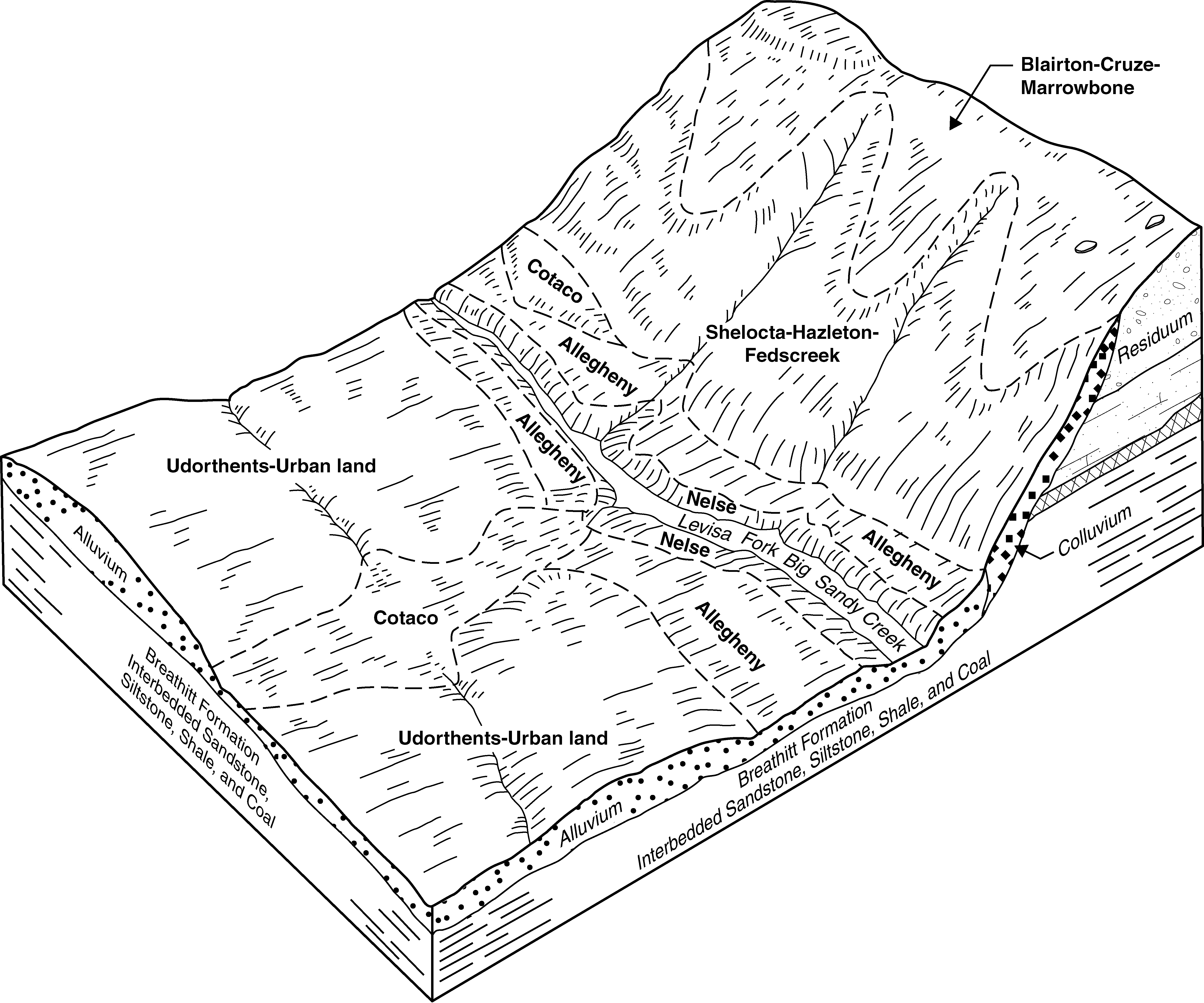
| Blairton-Cruze-Marrowbone complex, 12 to 25 percent slopes | BlD | 18134 | 1884681 | 21855 | ky063 | 2007 | 1:12000 |
Gilpin-Steinsburg-Blairton complex, 12 to 25 percent slopes | GtD | 10638 | 1884684 | 21858 | ky063 | 2007 | 1:12000 |
Marrowbone-Blairton-Matewan complex, 25 to 60 percent slopes, rocky | MaF | 2589 | 1884682 | 21856 | ky063 | 2007 | 1:12000 |
Gilpin-Blairton-Ramsey complex, 2 to 12 percent slopes | GbC | 2197 | 1884683 | 21857 | ky063 | 2007 | 1:12000 |
Blairton-Cruze-Marrowbone complex, 6 to 12 percent slopes | BlC | 540 | 1884680 | 21854 | ky063 | 2007 | 1:12000 |
Blairton silt loam, 12 to 30 percent slopes, eroded | BrE2 | 3870 | 552698 | 2xb0d | ky069 | 1989 | 1:20000 |
Blairton silt loam, 6 to 12 percent slopes, eroded | BrC2 | 3815 | 552697 | 2xb0c | ky069 | 1989 | 1:20000 |
Blairton silt loam, 2 to 6 percent slopes | BrB | 331 | 552696 | 2xb0b | ky069 | 1989 | 1:20000 |
Blairton silt loam, 12 to 30 percent slopes, eroded | BrE2 | 13403 | 550281 | 2xb0d | ky135 | 1998 | 1:20000 |
Blairton silt loam, 6 to 12 percent slopes, eroded | BrC2 | 4478 | 550280 | 2xb0c | ky135 | 1998 | 1:20000 |
Blairton silt loam, 2 to 6 percent slopes | BrB | 875 | 550279 | 2xb0b | ky135 | 1998 | 1:20000 |
Marrowbone-Blairton-Dekalb complex, 25 to 60 percent slopes, rocky | MaF | 22141 | 550908 | lh87 | ky640 | 1996 | 1:24000 |
Blairton-Cruze-Marrowbone complex, 12 to 25 percent slopes | BlD | 16756 | 550891 | lh7p | ky640 | 1996 | 1:24000 |
Blairton-Cruze-Marrowbone complex, 6 to 12 percent slopes | BlC | 729 | 550890 | lh7n | ky640 | 1996 | 1:24000 |
Blairton silt loam, 8 to 15 percent slopes | BnC | 2593 | 2401041 | 2llgy | md001 | 2009 | 1:12000 |
Blairton silt loam, 3 to 8 percent slopes | BnB | 713 | 2401040 | 2llgx | md001 | 2009 | 1:12000 |
Blairton silt loam, 15 to 25 percent slopes | BnD | 538 | 2401042 | 2llgz | md001 | 2009 | 1:12000 |
Blairton-Rarden-Gilpin association, rolling | BmC | 7 | 1460516 | 1l0sf | oh079 | 1981 | 1:15840 |
Coolville-Blairton association, rolling | CpC | 8657 | 537620 | l1fl | oh131 | 1984 | 1:15840 |
Blairton-Rarden-Gilpin association, rolling | BdC | 7864 | 537611 | l1f9 | oh131 | 1984 | 1:15840 |
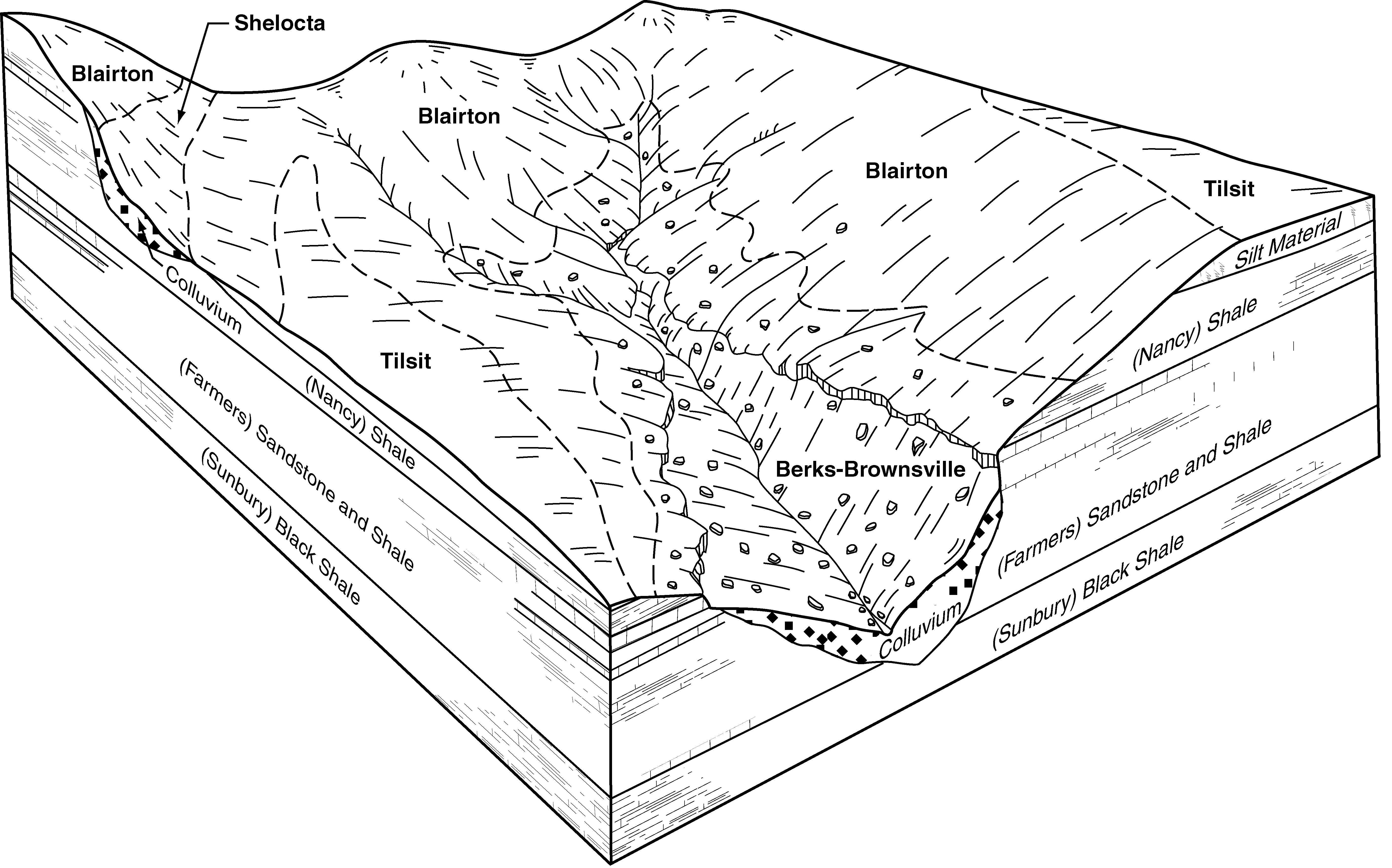
Blairton channery silt loam, 8 to 15 percent slopes | BrC | 10856 | 541771 | l5rh | pa009 | 1989 | 1:24000 |
Blairton channery silt loam, 15 to 25 percent slopes | BrD | 5638 | 541772 | l5rj | pa009 | 1989 | 1:24000 |
Blairton channery silt loam, 3 to 8 percent slopes | BrB | 3783 | 541770 | l5rg | pa009 | 1989 | 1:24000 |
Blairton silt loam, 8 to 15 percent slopes | BoC | 844 | 542328 | l6bg | pa013 | 1978 | 1:20000 |
Blairton silt loam, 3 to 8 percent slopes | BoB | 784 | 542327 | l6bf | pa013 | 1978 | 1:20000 |
Blairton silt loam, 3 to 8 percent slopes | BmB | 7360 | 541892 | l5wd | pa021 | 1978 | 1:20000 |
Blairton silt loam, 8 to 15 percent slopes | BmC | 2366 | 541893 | l5wf | pa021 | 1978 | 1:20000 |
Blairton-Berks channery silt loams, 8 to 15 percent slopes | BpC | 1622 | 541895 | l5wh | pa021 | 1978 | 1:20000 |
Blairton very stony silt loam, 3 to 8 percent slopes | BnB | 689 | 541894 | l5wg | pa021 | 1978 | 1:20000 |
Blairton silt loam, 3 to 8 percent slopes | BpB | 4134 | 693690 | r8v3 | pa041 | 1980 | 1:15840 |
Blairton channery silt loam, 3 to 8 percent slopes | BlB | 5303 | 545080 | l967 | pa055 | 1999 | 1:24000 |
Blairton channery silt loam, 0 to 3 percent slopes | BlA | 599 | 545079 | l966 | pa055 | 1999 | 1:24000 |
Blairton silt loam, 2 to 8 percent slopes | BoB | 1080 | 541965 | l5yr | pa061 | 1974 | 1:20000 |
Blairton silt loam, 8 to 15 percent slopes | BoC | 613 | 541966 | l5ys | pa061 | 1974 | 1:20000 |
Blairton silt loam, 3 to 10 percent slopes | Bm | 1649 | 542722 | l6r5 | pa071 | 1982 | 1:15840 |
Blairton silt loam, 3 to 8 percent slopes | BpB | 344 | 693915 | r92c | pa099 | 1980 | 1:15840 |
Blairton channery silt loam, 3 to 8 percent slopes | BnB | 2822 | 542065 | l61z | pa111 | 1977 | 1:20000 |
Blairton channery silt loam, 8 to 15 percent slopes | BnC | 521 | 542066 | l620 | pa111 | 1977 | 1:20000 |
Wharton-Blairton complex, 15 to 35 percent slopes | 55D | 552 | 834401 | x085 | va005 | 2003 | 1:24000 |
Wharton-Blairton complex, 8 to 15 percent slopes | 55C | 314 | 834400 | x084 | va005 | 2003 | 1:24000 |
Wharton-Blairton complex, 8 to 15 percent slopes | 61C | 524 | 1451426 | 1kqb6 | va017 | 2005 | 1:24000 |
Wharton-Blairton complex, 15 to 35 percent slopes | 61D | 486 | 1451427 | 1kqb7 | va017 | 2005 | 1:24000 |
Blairton-Wharton complex, 3 to 8 percent slopes | 8B | 255 | 1451425 | 1kqb5 | va017 | 2005 | 1:24000 |
Blairton silt loam, 2 to 7 percent slopes | 3B | 7664 | 521118 | kh88 | va069 | 1983 | 1:15840 |
Blairton silt loam, 7 to 15 percent slopes | 3C | 2335 | 521119 | kh89 | va069 | 1983 | 1:15840 |
Wharton-Blairton complex, 15 to 35 percent slopes | 58E | 499 | 2512113 | 2q9jz | va091 | 2010 | 1:24000 |
Blairton-Wharton complex, 3 to 8 percent slopes | 7B | 316 | 2512026 | 2q7v6 | va091 | 2010 | 1:24000 |
Wharton-Blairton complex, 8 to 15 percent slopes | 58C | 299 | 2512114 | 2q9k0 | va091 | 2010 | 1:24000 |
Blairton silt loam, 7 to 15 percent slopes | 4C | 1137 | 520779 | kgxb | va171 | 1988 | 1:15840 |
Blairton silt loam, 2 to 7 percent slopes | 4B | 868 | 520778 | kgx9 | va171 | 1988 | 1:15840 |
Blairton silt loam, 2 to 7 percent slopes | 2B | 1308 | 518838 | kdwq | va187 | 1980 | 1:15840 |
Blairton silt loam, 7 to 15 percent slopes | 2C | 303 | 518839 | kdwr | va187 | 1980 | 1:15840 |
Blairton-Urban land complex, 2 to 7 percent slopes | 503B | 110 | 3025548 | 2xd4z | va840 | 2017 | 1:12000 |
Blairton-Urban land complex, 7 to 15 percent slopes | 503C | 36 | 3025549 | 2xd50 | va840 | 2017 | 1:12000 |
Blairton silt loam, 2 to 7 percent slopes | 3B | 17 | 3025637 | 2xr7q | va840 | 2017 | 1:12000 |
Blairton silt loam, 7 to 15 percent slopes | 3C | 1 | 3025638 | 2xr7r | va840 | 2017 | 1:12000 |
Blairton silt loam, 3 to 8 percent slopes | BoB | 712 | 515376 | k991 | wv075 | 1992 | 1:24000 |


