Taluce-Tullock-Vonalee association, moist, 9 to 30 percent slopes
Taluce
(31%)
Shallow Sandy (SwSy) 10-14 PZ
Ustic Torriorthents
Somewhat excessively drained
Hydric: No
PAWS: 5 cm
hills
ridges
Tullock
(29%)
Sandy (Sy) 15-19 Northern Plains Precipitation Zone
Ustic Torripsamments
Excessively drained
Hydric: No
PAWS: 6 cm
ridges / Summit
ridges / Shoulder
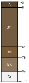
Vonalee
(25%)
Sandy (Sy) 15-19 Northern Plains Precipitation Zone
Ustic Haplargids
Somewhat excessively drained
Hydric: No
PAWS: 15 cm
hillsides / Backslope
hillsides / Footslope
Hiland
(5%)
Sandy (Sy) 15-19 Northern Plains Precipitation Zone
Hydric: No
PAWS: NA
Bowbac
(5%)
Sandy (Sy) 15-19 Northern Plains Precipitation Zone
Ustic Haplargids
Hydric: No
PAWS: NA
Rock outcrop
(5%)
Hydric: No
PAWS: NA
SSA
Scale
Published
Export
wy633
1:24,000
1987
2025-09-04