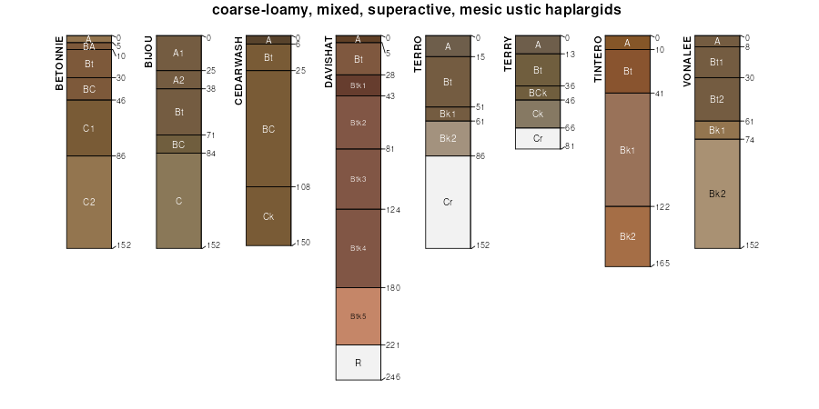
| Vonalee-Terro-Taluce fine sandy loams, 3 to 30 percent slopes | 333 | 36 | 1387778 | 2wxz1 | mt643 | 1967 | 1:20000 |
Hiland-Vonalee fine sandy loams, 6 to 15 percent slopes | 259 | 101 | 780263 | v5xs | wy011 | 1978 | 1:24000 |
Terro-Vonalee-Taluce association, 6 to 30 percent slopes | 203 | 30603 | 349714 | cqx3 | wy027 | 1993 | 1:24000 |
Vonalee-Keeline fine sandy loams, 2 to 10 percent slopes | 223 | 7971 | 349734 | cqxr | wy027 | 1993 | 1:24000 |
Terro-Vonalee sandy loams, 0 to 6 percent slopes | 202 | 7423 | 349713 | cqx2 | wy027 | 1993 | 1:24000 |
Vonalee sandy loam, 0 to 6 percent slopes | 222 | 3882 | 349733 | cqxq | wy027 | 1993 | 1:24000 |
Vonalee fine sandy loam, 0 to 6 percent slopes | 258 | 7512 | 104609 | 3hvh | wy031 | 1998 | 1:24000 |
Hiland-Bunkwater-Vonalee complex, 1 to 15 percent slopes | 2204 | | 3356660 | 2wxmq | wy043 | 1976 | 1:24000 |
Vonalee-Terro complex, 2 to 10 percent slopes | 126 | 45661 | 349411 | 2xtvw | wy045 | 1984 | 1:24000 |
Hiland-Vonalee association, rolling | 50 | 8175 | 349455 | cqmr | wy045 | 1984 | 1:24000 |
Terro-Vonalee sandy loams, 0 to 6 percent slopes | 163 | 922 | 1614848 | 1r6cw | wy045 | 1984 | 1:24000 |
Hiland-Vonalee fine sandy loams, 0 to 6 percent slopes | 138 | 715 | 361690 | 2yv7l | wy045 | 1984 | 1:24000 |
Vonalee sandy loam, 0 to 6 percent slopes | 165 | 100 | 1614850 | 1r6cy | wy045 | 1984 | 1:24000 |
Hiland-Bunkwater-Vonalee complex, 1 to 15 percent slopes | 2204 | 250 | 3170875 | 2wxmq | wy603 | | 1:24000 |
Hiland-Vonalee fine sandy loams, 0 to 6 percent slopes | 159 | 12405 | 349849 | 2yv7l | wy605 | 1995 | 1:24000 |
Vonalee-Terro fine sandy loams, 2 to 10 percent slopes | 236 | 11884 | 349936 | 2wxz0 | wy605 | 1995 | 1:24000 |
Hiland-Vonalee fine sandy loams, 6 to 15 percent slopes | 160 | 5527 | 349851 | cr1j | wy605 | 1995 | 1:24000 |
Vonalee fine sandy loam, 0 to 10 percent slopes | 235 | 3346 | 349935 | cr47 | wy605 | 1995 | 1:24000 |
Vonalee-Terro fine sandy loams, 6 to 15 percent slopes | 266 | 13378 | 1669769 | 2yv7c | wy609 | 2006 | 1:24000 |
Vonalee-Terro fine sandy loams, 0 to 6 percent slopes | 265 | 12955 | 1669768 | 2yv7d | wy609 | 2006 | 1:24000 |
Vonalee fine sandy loam, 0 to 6 percent slopes | 264 | 4337 | 1669754 | 1t1j1 | wy609 | 2006 | 1:24000 |
Taluce-Tullock-Vonalee association, 6 to 30 percent slopes | 243 | 956 | 1669743 | 1t1hp | wy609 | 2006 | 1:24000 |
Tassel-Tullock-Vonalee complex, 6 to 30 percent slopes | 246 | 561 | 1669783 | 2wxyv | wy609 | 2006 | 1:24000 |
Hiland-Bunkwater-Vonalee complex, 1 to 15 percent slopes | 2204 | 3300 | 3197045 | 2wxmq | wy617 | | 1:24000 |
Remmit-Taluce-Vonalee complex, 8 to 30 percent slopes | 5448 | 152 | 3170864 | 2w7k1 | wy617 | | 1:24000 |
Remmit-Vonalee-Jerome-like complex, 6 to 25 percent slopes, frequently flooded | 1305 | 33 | 3170841 | 2y4y7 | wy617 | | 1:24000 |
Hiland-Vonalee fine sandy loams, 6 to 15 percent slopes | 160 | 29 | 817243 | wfdp | wy619 | 1971 | 1:24000 |
Vonalee-Terro fine sandy loams, 2 to 10 percent slopes | 717 | 9 | 2383674 | 2wxz0 | wy619 | 1971 | 1:24000 |
Vonalee-Hiland complex, 3 to 15 percent slopes | 301 | 69277 | 502439 | 2v09d | wy625 | 1985 | 1:24000 |
Vonalee loamy sand, 3 to 10 percent slopes | 300 | 29223 | 502437 | 2yrxx | wy625 | 1985 | 1:24000 |
Terro-Vonalee association, rolling | 282 | 11121 | 502418 | jvt1 | wy625 | 1985 | 1:24000 |
Orpha-Vonalee-Roughlock complex, 9 to 30 percent slopes | 231 | 3644 | 502352 | jvqx | wy625 | 1985 | 1:24000 |
Vonalee-Slickspots complex, 3 to 15 percent slopes | 302 | 3424 | 502441 | jvts | wy625 | 1985 | 1:24000 |
Tassel-Tullock-Vonalee complex, 6 to 30 percent slopes | 325 | 148 | 1426083 | 2wxyv | wy625 | 1985 | 1:24000 |
Vonalee-Terro complex, 6 to 15 percent slopes | 327 | 99 | 1426085 | 1jvyr | wy625 | 1985 | 1:24000 |
Hiland-Bunkwater-Vonalee complex, 1 to 15 percent slopes | 2204 | 2111 | 2969097 | 2wxmq | wy629 | | 1:24000 |
Vonalee-Remmit complex, 6 to 15 percent slopes | 5449 | 1575 | 2911927 | 2w7k2 | wy629 | | 1:24000 |
Dwyer-Vonalee complex, 2 to 6 percent slopes | 2222 | 1252 | 2911903 | 2w7j9 | wy629 | | 1:24000 |
Oregon Basin-Vonalee-Hiland complex, 1 to 8 percent slopes | 1111 | 1125 | 2969035 | 2wxk2 | wy629 | | 1:24000 |
Vonalee-Vonid complex, 4 to 12 percent slopes | 2313 | 240 | 3133233 | 2ynlr | wy629 | | 1:24000 |
Bunkwater-Vonalee complex, 0 to 2 percent slopes | 2142 | 234 | 3133268 | 2ynmw | wy629 | | 1:24000 |
Remmit-Vonalee-Jerome-like complex, 6 to 25 percent slopes, frequently flooded | 1305 | 176 | 2911953 | 2y4y7 | wy629 | | 1:24000 |
Remmit-Taluce-Vonalee complex, 8 to 30 percent slopes | 5448 | 173 | 2911926 | 2w7k1 | wy629 | | 1:24000 |
Ralstonflats-Vonalee complex, 6 to 20 percent slopes | 2361 | 119 | 3253279 | 2ztjs | wy629 | | 1:24000 |
Vonalee sandy loam, 0 to 3 percent slopes | 76A | 81 | 152659 | 53vh | wy629 | | 1:24000 |
Vonalee sandy loam, 3 to 6 percent slopes | 76B | 40 | 152660 | 53vj | wy629 | | 1:24000 |
Bessemer-Vonalee complex, 10 to 25 percent slopes | 2423 | 27 | 3170980 | 2z20c | wy629 | | 1:24000 |
Taluce-Tullock-Vonalee association, moist, 9 to 30 percent slopes | 279 | 7814 | 361054 | d3px | wy633 | 1987 | 1:24000 |
Taluce-Tullock-Vonalee association, 6 to 15 percent slopes | 278 | 3103 | 361044 | d3pl | wy633 | 1987 | 1:24000 |
Hiland-Vonalee complex, moist, 3 to 10 percent slopes | 167 | 1352 | 361152 | d3t2 | wy633 | 1987 | 1:24000 |
Hiland-Vonalee fine sandy loams, 6 to 15 percent slopes | 659 | 14 | 2389972 | w9zc | wy633 | 1987 | 1:24000 |
Vonalee-Terro-Taluce fine sandy loams, 3 to 30 percent slopes | 331 | 12 | 361233 | 2wxz1 | wy633 | 1987 | 1:24000 |
Vonalee-Terro-Taluce fine sandy loams, 3 to 30 percent slopes | 333 | 1869 | 817605 | 2wxz1 | wy705 | 2003 | 1:24000 |
Vonalee-Terro fine sandy loams, 2 to 10 percent slopes | 236 | 278 | 817604 | 2wxz0 | wy705 | 2003 | 1:24000 |
Tassel-Tullock-Vonalee complex, 6 to 30 percent slopes | 137 | 72041 | 351515 | 2wxyv | wy709 | 1983 | 1:24000 |
Vonalee-Terro complex, 6 to 15 percent slopes | 147 | 9060 | 351525 | cssj | wy709 | 1983 | 1:24000 |
Vonalee-Terro complex, 0 to 6 percent slopes | 146 | 4025 | 351524 | cssh | wy709 | 1983 | 1:24000 |
Vonalee-Hiland complex, undulating | 220 | 36901 | 503099 | jwj0 | wy713 | 1986 | 1:24000 |
Orpha-Vonalee complex, hilly | 178 | 24843 | 503043 | jwg6 | wy713 | 1986 | 1:24000 |
Vonalee-Terro-Taluce fine sandy loams, 3 to 30 percent slopes | 718 | 18445 | 813987 | 2wxz1 | wy719 | 2013 | 1:24000 |
Vonalee-Terro fine sandy loams, 2 to 10 percent slopes | 717 | 5654 | 1399146 | 2wxz0 | wy719 | 2013 | 1:24000 |
Hiland-Vonalee fine sandy loams, 6 to 15 percent slopes | 659 | 2185 | 813947 | w9zc | wy719 | 2013 | 1:24000 |
Vonalee fine sandy loam, 0 to 6 percent slopes | 194 | 960 | 104995 | 3j7y | wy721 | 1994 | 1:24000 |