| Vonalee-Terro-Taluce fine sandy loams, 3 to 30 percent slopes | 333 | 36 | 1387778 | 2wxz1 | mt643 | 1967 | 1:20000 |
Shingle-Taluce complex, 3 to 30 percent slopes | 249 | 700 | 780257 | 2yryp | wy011 | 1978 | 1:24000 |
Taluce-Rock outcrop-Shingle complex, 6 to 45 percent slopes | 194 | 111268 | 349701 | 2wxz9 | wy027 | 1993 | 1:24000 |
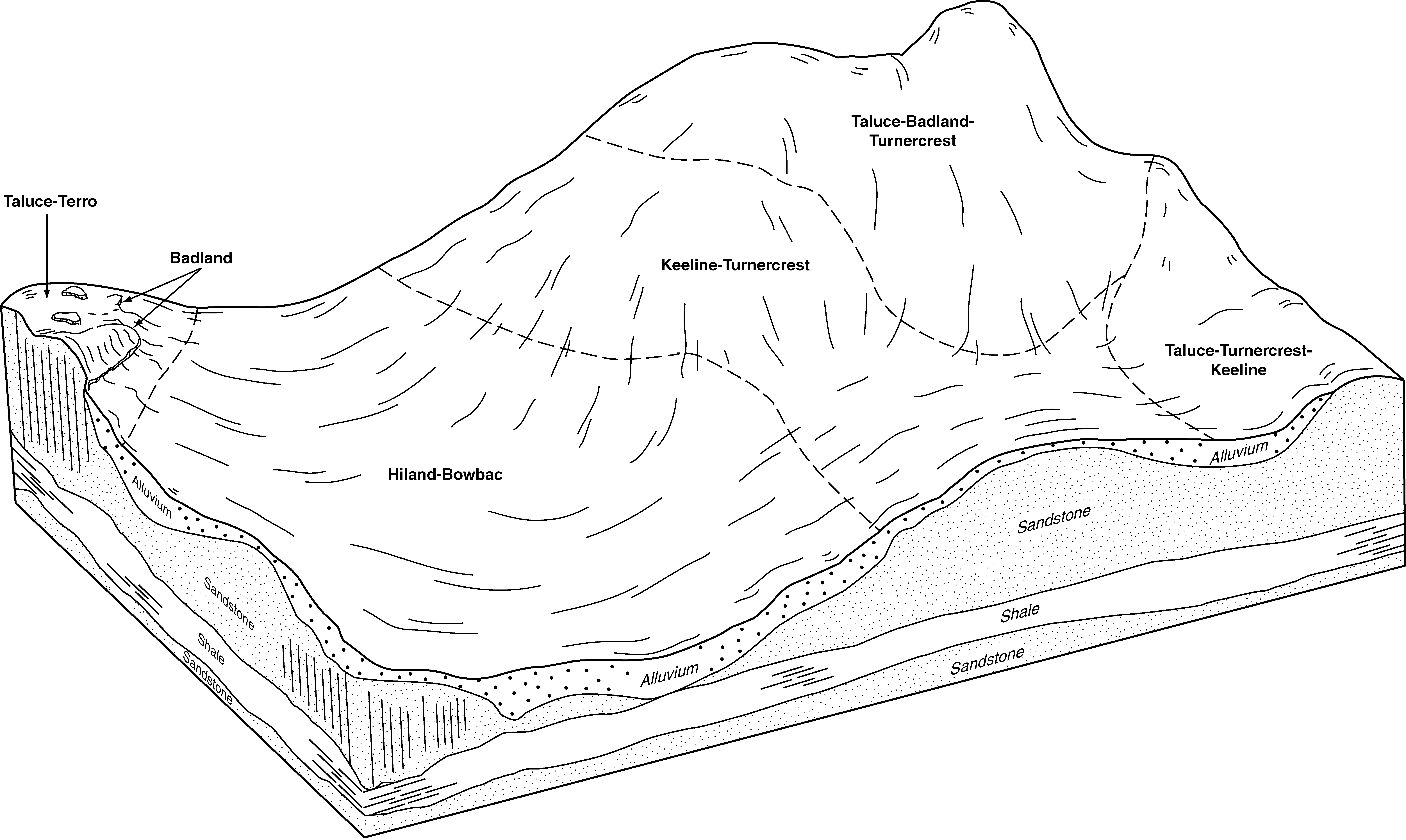
Taluce-Turnercrest-Keeline fine sandy loams, 3 to 20 percent slopes | 198 | 42300 | 349709 | cqwy | wy027 | 1993 | 1:24000 |
Terro-Vonalee-Taluce association, 6 to 30 percent slopes | 203 | 30603 | 349714 | cqx3 | wy027 | 1993 | 1:24000 |
Taluce-Shingle complex, 3 to 20 percent slopes | 196 | 14010 | 349705 | cqwt | wy027 | 1993 | 1:24000 |
Taluce-Tullock-Rock outcrop complex, 3 to 45 percent slopes | 197 | 13722 | 349707 | cqww | wy027 | 1993 | 1:24000 |
Taluce, cool-Keeline fine sandy loams, 6 to 40 percent slopes | 193 | 10000 | 349699 | cqwm | wy027 | 1993 | 1:24000 |
Orpha-Dwyer-Taluce complex, 6 to 15 percent slopes | 170 | 3418 | 349653 | cqv4 | wy027 | 1993 | 1:24000 |
Taluce-Rock outcrop-Turnercrest complex, 6 to 50 percent slopes | 195 | 766 | 349703 | cqwr | wy027 | 1993 | 1:24000 |
Taluce, thin solum-Rock outcrop-Turnercrest complex, 6 to 50 percent slopes | 235 | 47235 | 104590 | 3htw | wy031 | 1998 | 1:24000 |
Keeline-Taluce-Turnercrest fine sandy loams, 3 to 40 percent slopes | 179 | 41175 | 104533 | 3hs1 | wy031 | 1998 | 1:24000 |
Cascajo-Taluce-Badland complex, 6 to 40 percent slopes | 122 | 32524 | 104478 | 3hq8 | wy031 | 1998 | 1:24000 |
Keeline-Nidix-Taluce complex, 10 to 60 percent slopes | 178 | 28457 | 104532 | 3hs0 | wy031 | 1998 | 1:24000 |
Taluce-Rock outcrop-Turnercrest complex, moist, 6 to 50 percent slopes | 237 | 21834 | 104592 | 3hty | wy031 | 1998 | 1:24000 |
Taluce-Turnercrest-Keeline fine sandy loams, 3 to 20 percent slopes | 242 | 21543 | 104597 | 3hv3 | wy031 | 1998 | 1:24000 |
Taluce-Turnercrest sandy loams, 0 to 6 percent slopes | 241 | 13730 | 104596 | 3hv2 | wy031 | 1998 | 1:24000 |
Taluce-Badland-Turnercrest complex, 6 to 50 percent slopes | 236 | 11505 | 104591 | 2yv7b | wy031 | 1998 | 1:24000 |
Taluce, thin solum-Keeline complex, 6 to 50 percent slopes | 234 | 6095 | 104589 | 3htv | wy031 | 1998 | 1:24000 |
Taluce-Treon complex, thin solums, 6 to 10 percent slopes | 240 | 5160 | 104595 | 3hv1 | wy031 | 1998 | 1:24000 |
Turnercrest-Phiferson-Taluce complex, 0 to 6 percent slopes | 251 | 3675 | 104603 | 3hv9 | wy031 | 1998 | 1:24000 |
Taluce, thin solum-Rock outcrop complex, 10 to 60 percent slopes | 233 | 2872 | 104588 | 3htt | wy031 | 1998 | 1:24000 |
Taluce-Taluce, thin solum-Turnercrest fine sandy loams, 3 to 15 percent slopes | 239 | 882 | 104594 | 3hv0 | wy031 | 1998 | 1:24000 |
Taluce-Taluce, thin solum-Badland complex, 3 to 30 percent slopes | 238 | 752 | 104593 | 3htz | wy031 | 1998 | 1:24000 |
Taluce-Shingle-Samday complex, 15 to 50 percent slopes | 5450 | | 3356673 | 2w7k3 | wy043 | 1976 | 1:24000 |
Taluce-Rock outcrop-Turnercrest complex, 6 to 50 percent slopes | 161 | 2218 | 1614846 | 1r6ct | wy045 | 1984 | 1:24000 |
Shingle-Taluce complex, 3 to 30 percent slopes | 140 | 254 | 361695 | 2yryp | wy045 | 1984 | 1:24000 |
Taluce-Turnercrest-Keeline fine sandy loams, 3 to 20 percent slopes | 162 | 181 | 1614847 | 1r6cv | wy045 | 1984 | 1:24000 |
Turnercrest-Keeline-Taluce fine sandy loams, 6 to 30 percent slopes | 141 | 148 | 361694 | 2wlrv | wy045 | 1984 | 1:24000 |
Gateson-Taluce-Turnercrest complex, wooded, 6 to 30 percent slopes | 136 | 123 | 361692 | 2ztzn | wy045 | 1984 | 1:24000 |
Taluce-Travessilla complex, 10 to 60 percent slopes | 446DE | 29693 | 152221 | 53dc | wy603 | | 1:24000 |
Neville-Taluce complex, 1 to 30 percent slopes | 389CE | 7788 | 152192 | 53cf | wy603 | | 1:24000 |
Badland-Oceanet-Taluce complex, 15 to 60 percent slopes | 5418 | 803 | 3170885 | 2wxmt | wy603 | | 1:24000 |
Turnercrest-Keeline-Taluce fine sandy loams, 6 to 30 percent slopes | 221 | 17870 | 349921 | 2wlrv | wy605 | 1995 | 1:24000 |
Shingle-Taluce complex, 3 to 30 percent slopes | 210 | 11667 | 349908 | 2yryp | wy605 | 1995 | 1:24000 |
Gateson-Taluce-Turnercrest complex, wooded, 6 to 30 percent slopes | 150 | 11461 | 349835 | 2ztzn | wy605 | 1995 | 1:24000 |
Hilight-Taluce, cool-Wags complex, 6 to 40 percent slopes | 161 | 5187 | 349852 | cr1k | wy605 | 1995 | 1:24000 |
Terro-Taluce sandy loams, 6 to 30 percent slopes | 213 | 4153 | 349913 | cr3j | wy605 | 1995 | 1:24000 |
Embry-Taluce sandy loams, 3 to 20 percent slopes | 140 | 3100 | 349825 | cr0p | wy605 | 1995 | 1:24000 |
Turnercrest-Wibaux, thin solum-Taluce complex, 6 to 40 percent slopes | 222 | 1258 | 349922 | cr3t | wy605 | 1995 | 1:24000 |
Bowbac-Taluce-Badland complex, 3 to 20 percent slopes | 114 | 1074 | 349799 | cqzv | wy605 | 1995 | 1:24000 |
Shingle-Taluce-Badland complex, 10 to 40 percent slopes | 233 | 49305 | 1669734 | 2v09k | wy609 | 2006 | 1:24000 |
Shingle-Taluce complex, 6 to 40 percent slopes, very cobbly | 232 | 38186 | 1669775 | 2wlqy | wy609 | 2006 | 1:24000 |
Shingle, thin solum-Badland-Taluce, thin solum complex, wooded, 6 to 45 percent slopes | 229 | 23175 | 1669772 | 2yv7s | wy609 | 2006 | 1:24000 |
Taluce-Turnercrest-Keeline fine sandy loams, 3 to 20 percent slopes | 244 | 18081 | 1669740 | 2yry6 | wy609 | 2006 | 1:24000 |
Taluce-Badland-Turnercrest complex, 6 to 50 percent slopes | 238 | 13780 | 1669738 | 2yv7b | wy609 | 2006 | 1:24000 |
Worf-Shingle-Taluce complex, 3 to 30 percent slopes | 269 | 11635 | 1669759 | 2ztzj | wy609 | 2006 | 1:24000 |
Taluce-Taluce, thin solum-Badland complex, 3 to 30 percent slopes | 240 | 5624 | 1669739 | 1t1hk | wy609 | 2006 | 1:24000 |
Cascajo-Taluce-Badland complex, 6 to 40 percent slopes | 118 | 4609 | 1669666 | 1t1f6 | wy609 | 2006 | 1:24000 |
Taluce-Terro-Badland complex, 15 to 30 percent slopes | 242 | 3436 | 1669742 | 1t1hn | wy609 | 2006 | 1:24000 |
Badland-Taluce complex, 6 to 70 percent slopes | 108 | 2995 | 1669726 | 1t1h4 | wy609 | 2006 | 1:24000 |
Taluce-Shingle complex, 6 to 30 percent slopes | 239 | 2712 | 1669741 | 1t1hm | wy609 | 2006 | 1:24000 |
Taluce-Taluce, thin solum-Turnercrest fine sandy loams, 3 to 15 percent slopes | 241 | 1694 | 1669767 | 1t1jg | wy609 | 2006 | 1:24000 |
Taluce-Tullock-Vonalee association, 6 to 30 percent slopes | 243 | 956 | 1669743 | 1t1hp | wy609 | 2006 | 1:24000 |
Taluce-Worf-Shingle complex, 8 to 30 percent slopes | 5411 | 5028 | 3170861 | 2w7h9 | wy617 | | 1:24000 |
Taluce-Shingle-Samday complex, 15 to 50 percent slopes | 5450 | 2089 | 3358287 | 2w7k3 | wy617 | | 1:24000 |
Bunkwater-like-Taluce complex, 2 to 6 percent slopes | 5202 | 331 | 3170845 | 2y4yk | wy617 | | 1:24000 |
Remmit-Taluce-Vonalee complex, 8 to 30 percent slopes | 5448 | 152 | 3170864 | 2w7k1 | wy617 | | 1:24000 |
Shingle-Taluce-Badland complex, 10 to 40 percent slopes | 275 | 1431 | 816920 | 2wlqz | wy619 | 1971 | 1:24000 |
Shingle-Taluce complex, 3 to 30 percent slopes | 210 | 700 | 817249 | 2yryp | wy619 | 1971 | 1:24000 |
Bowbac-Taluce-Terro complex, 6 to 20 percent slopes | 134 | 207 | 816594 | 2wxyy | wy619 | 1971 | 1:24000 |
Terro-Taluce sandy loams, 6 to 30 percent slopes | 213 | 110 | 817250 | wfdx | wy619 | 1971 | 1:24000 |
Bowbac-Taluce-Badland complex, 3 to 20 percent slopes | 114 | 76 | 816861 | wf0c | wy619 | 1971 | 1:24000 |
Shingle-Taluce-Badland complex, 10 to 40 percent slopes | 275 | 65363 | 502411 | 2wlqz | wy625 | 1985 | 1:24000 |
Bowbac-Taluce-Terro complex, 6 to 20 percent slopes | 134 | 61579 | 502212 | 2wxyy | wy625 | 1985 | 1:24000 |
Keeline-Taluce-Rock outcrop complex, 6 to 20 percent slopes | 207 | 10797 | 502303 | jvpb | wy625 | 1985 | 1:24000 |
Shingle-Taluce-Badland complex, 10 to 40 percent slopes | 317 | 142 | 1398299 | 2v09k | wy625 | 1985 | 1:24000 |
Taluce-Turnercrest-Keeline fine sandy loams, 3 to 20 percent slopes | 314 | 107 | 1398298 | 1hy1d | wy625 | 1985 | 1:24000 |
Taluce-Badland-Turnercrest complex, 6 to 50 percent slopes | 315 | 24 | 1398297 | 2yv7b | wy625 | 1985 | 1:24000 |
Cambria-like-Taluce-Turnback-like complex, 4 to 30 percent slopes | 5425 | 9484 | 2969110 | 2y62q | wy629 | | 1:24000 |
Bunkwater-like-Taluce complex, 2 to 6 percent slopes | 5202 | 4723 | 2911963 | 2y4yk | wy629 | | 1:24000 |
Chugcity-like-Taluce-Rock outcrop complex, 8 to 35 percent slopes | 5412 | 4061 | 2911858 | 2w7h8 | wy629 | | 1:24000 |
Badland-Oceanet-Taluce complex, 15 to 60 percent slopes | 5418 | 4020 | 2969100 | 2wxmt | wy629 | | 1:24000 |
Taluce-Oceanet-Badland complex, 15 to 65 percent slopes | 5514 | 3519 | 2969115 | 2y62w | wy629 | | 1:24000 |
Taluce-Worf-Shingle complex, 8 to 30 percent slopes | 5411 | 3322 | 2911859 | 2w7h9 | wy629 | | 1:24000 |
Taluce-Worfka-Worf complex, 2 to 15 percent slopes | 5206 | 2632 | 2911893 | 2w7j1 | wy629 | | 1:24000 |
Bowbac-Taluce-Worf complex, 10 to 35 percent slopes | 5414 | 1513 | 2911883 | 2w7hr | wy629 | | 1:24000 |
Taluce-Shingle-Samday complex, 15 to 50 percent slopes | 5450 | 823 | 2911928 | 2w7k3 | wy629 | | 1:24000 |
Badger Gulch-Badland-Taluce complex, 3 to 25 percent slopes | 2307 | 684 | 2969031 | 2wxjx | wy629 | | 1:24000 |
Alvey-like-Hiland-like-Taluce complex, 2 to 10 percent slopes | 5335 | 390 | 3133259 | 2ynml | wy629 | | 1:24000 |
Taluce, very bouldery-Zigweid complex, 15 to 50 percent slopes | 5820 | 342 | 3203139 | 2zy9x | wy629 | | 1:24000 |
Remmit-Taluce-Vonalee complex, 8 to 30 percent slopes | 5448 | 173 | 2911926 | 2w7k1 | wy629 | | 1:24000 |
Maysdorf-Remmit-Taluce complex, 6 to 20 percent slopes | 5365 | 167 | 3170982 | 2z20f | wy629 | | 1:24000 |
Taluce-Remmit-Chugcity-like complex, 15 to 60 percent slopes | 5564 | 165 | 3253230 | 2zthm | wy629 | | 1:24000 |
Galbreth-like-Blacksheep-Taluce complex, 5 to 50 percent slopes | 5810 | 134 | 3206693 | 2zc6m | wy629 | | 1:24000 |
Birdsley-Taluce-Rock outcrop complex, 15 to 70 percent slopes | 5594 | 116 | 3250491 | 2zv7d | wy629 | | 1:24000 |
Shingle-Taluce complex, moist, 9 to 15 percent slopes | 265 | 10498 | 3460753 | 31x3y | wy633 | 1987 | 1:24000 |
Taluce-Tullock-Vonalee association, moist, 9 to 30 percent slopes | 279 | 7814 | 361054 | d3px | wy633 | 1987 | 1:24000 |
Taluce-Tullock-Vonalee association, 6 to 15 percent slopes | 278 | 3103 | 361044 | d3pl | wy633 | 1987 | 1:24000 |
Shingle-Taluce complex, 9 to 15 percent slopes | 264 | 2589 | 361048 | d3pq | wy633 | 1987 | 1:24000 |
Taluce-Tullock-Rock outcrop association, 3 to 15 percent slopes | 277 | 1602 | 361045 | d3pm | wy633 | 1987 | 1:24000 |
Shingle-Taluce-Badland complex, wooded, 6 to 45 percent slopes | 327 | 541 | 361229 | d3wk | wy633 | 1987 | 1:24000 |
Wibaux-Shingle-Taluce complex, wooded, 6 to 40 percent slopes | 333 | 212 | 361235 | d3wr | wy633 | 1987 | 1:24000 |
Wibaux-Shingle-Taluce complex, 6 to 40 percent slopes | 332 | 62 | 3460755 | 31x41 | wy633 | 1987 | 1:24000 |
Vonalee-Terro-Taluce fine sandy loams, 3 to 30 percent slopes | 331 | 12 | 361233 | 2wxz1 | wy633 | 1987 | 1:24000 |
Birdsley-Taluce-Rock outcrop complex, 15 to 70 percent slopes | 5594 | 401 | 3250532 | 2zv7d | wy656 | 2008 | 1:24000 |
Bowbac-Taluce complex, 3 to 45 percent slopes | 210D | 46 | 157954 | 59c9 | wy656 | 2008 | 1:24000 |
Alvey-like-Hiland-like-Taluce complex, 2 to 10 percent slopes | 5335 | 6 | 3253344 | 2ynml | wy656 | 2008 | 1:24000 |
Shingle-Taluce-Badland complex, wooded, 6 to 45 percent slopes | 316 | 3727 | 817641 | wftj | wy705 | 2003 | 1:24000 |
Wibaux-Shingle-Taluce complex, 6 to 40 percent slopes | 335 | 3339 | 3460763 | 31x41 | wy705 | 2003 | 1:24000 |
Wibaux-Shingle-Taluce complex, wooded, 6 to 40 percent slopes | 336 | 2720 | 817650 | wftt | wy705 | 2003 | 1:24000 |
Vonalee-Terro-Taluce fine sandy loams, 3 to 30 percent slopes | 333 | 1869 | 817605 | 2wxz1 | wy705 | 2003 | 1:24000 |
Turnercrest-Keeline-Taluce fine sandy loams, 6 to 30 percent slopes | 221 | 1429 | 817588 | 2wlrv | wy705 | 2003 | 1:24000 |
Shingle-Taluce-Badland complex, 6 to 45 percent slopes | 315 | 306 | 817579 | wfrj | wy705 | 2003 | 1:24000 |
Shingle-Taluce complex, 3 to 30 percent slopes | 210 | 119 | 817630 | 2yryp | wy705 | 2003 | 1:24000 |
Taluce-Shingle complex, 3 to 20 percent slopes | 231 | 593 | 1427849 | 1jxsn | wy709 | 1983 | 1:24000 |
Shingle-Taluce complex, 3 to 30 percent slopes | 209 | 316 | 361281 | 2yryp | wy709 | 1983 | 1:24000 |
Taluce-Turnercrest-Keeline fine sandy loams, 3 to 20 percent slopes | 233 | 221 | 1427851 | 1jxsq | wy709 | 1983 | 1:24000 |
Taluce-Tullock-Rock outcrop complex, 3 to 45 percent slopes | 232 | 151 | 1427850 | 1jxsp | wy709 | 1983 | 1:24000 |
Taluce-Bowbac sandy loams, hilly | 210 | 5518 | 503086 | jwhl | wy713 | 1986 | 1:24000 |
Orpha-Dwyer-Taluce complex, 6 to 15 percent slopes | 68 | 233 | 1415170 | 1jhln | wy715 | 1974 | 1:20000 |
Taluce, thin solum-Rock outcrop-Turnercrest complex, 6 to 50 percent slopes | 39 | 37 | 1414809 | 1jh70 | wy715 | 1974 | 1:20000 |
Cascajo-Taluce-Badland complex, 6 to 40 percent slopes | 37 | 25 | 1414807 | 1jh6y | wy715 | 1974 | 1:20000 |
Taluce-Badland-Turnercrest complex, 6 to 50 percent slopes | 52 | 19 | 1414821 | 2yv7b | wy715 | 1974 | 1:20000 |
Vonalee-Terro-Taluce fine sandy loams, 3 to 30 percent slopes | 718 | 18445 | 813987 | 2wxz1 | wy719 | 2013 | 1:24000 |
Wibaux-Shingle-Taluce complex, 6 to 40 percent slopes | 720 | 10860 | 3460747 | 31x41 | wy719 | 2013 | 1:24000 |
Shingle-Taluce complex, 6 to 40 percent slopes, very cobbly | 726 | 9600 | 1469311 | 2wlqy | wy719 | 2013 | 1:24000 |
Shingle-Taluce-Badland complex, 6 to 45 percent slopes | 695 | 9153 | 813985 | wb0l | wy719 | 2013 | 1:24000 |
Turnercrest-Keeline-Taluce fine sandy loams, 6 to 30 percent slopes | 711 | 5517 | 1399144 | 2wlrv | wy719 | 2013 | 1:24000 |
Terro-Taluce sandy loams, 6 to 30 percent slopes | 705 | 1456 | 813950 | w9zg | wy719 | 2013 | 1:24000 |
Taluce-Taluce, thin solum-Turnercrest fine sandy loams, 3 to 15 percent slopes | 169 | 3310 | 104970 | 3j74 | wy721 | 1994 | 1:24000 |
Taluce-Taluce, thin solum-Rock outcrop complex, 3 to 30 percent slopes | 168 | 1737 | 104969 | 3j73 | wy721 | 1994 | 1:24000 |