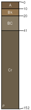
Cabbart-Blacksheep-Rock outcrop complex, 30 to 70 percent slopes
Cabbart
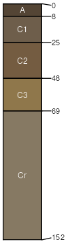
(35%)
Shallow (Sw) RRU 58A-E 10-14 p.z.
Aridic Ustorthents
Well drained
Hydric: No
PAWS: 6 cm
high hills / Summit
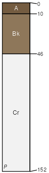
Blacksheep
(30%)
Shallow (Sw) RRU 58A-E 10-14 p.z.
Aridic Ustorthents
Well drained
Hydric: No
PAWS: 5 cm
high hills / Summit
Rock outcrop
(25%)
Hydric:
PAWS: NA
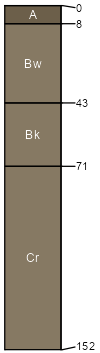
Delpoint
(6%)
Silty-Steep (SiStp) RRU 58A-E 10-14 p.z.
Aridic Haplustepts
Well drained
Hydric: No
PAWS: 9 cm
high hills / Backslope
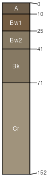
Twilight
(2%)
Sandy-Steep (SyStp) RRU 58A-E 10-14 p.z.
Haplocalcidic Haplustepts
Well drained
Hydric: No
PAWS: 10 cm
high hills / Backslope
Tusler
(2%)
Sands (Sa) RRU 58A-E 10-14 p.z.
Aridic Ustipsamments
Somewhat excessively drained
Hydric: No
PAWS: 7 cm
high hills / Footslope
SSA
Scale
Published
Export
mt103
1:20,000
1961
2025-08-29