| Delpoint-Cabbart complex, 8 to 15 percent slopes | 171D | 29532 | 342960 | chw7 | mt011 | 1992 | 1:24000 |
Yamacall-Cabbart loams, 15 to 35 percent slopes | 386E | 26462 | 343099 | cj0q | mt011 | 1992 | 1:24000 |
Cabbart-Rock outcrop-Delpoint complex, 15 to 50 percent slopes | 160E | 23126 | 342928 | 2tvlw | mt011 | 1992 | 1:24000 |
Cabbart-Rock outcrop-Yawdim complex, 15 to 70 percent slopes | 160F | 21845 | 342929 | chv7 | mt011 | 1992 | 1:24000 |
Cabbart-Cambeth silt loams, 8 to 15 percent slopes | 260D | 20988 | 343055 | 2w2cm | mt011 | 1992 | 1:24000 |
Bonfri-Cabbart loams, 8 to 15 percent slopes | 291D | 8929 | 343073 | 2yvmt | mt011 | 1992 | 1:24000 |
Delpoint-Cabbart complex, 2 to 8 percent slopes | 171C | 8541 | 342959 | chw6 | mt011 | 1992 | 1:24000 |
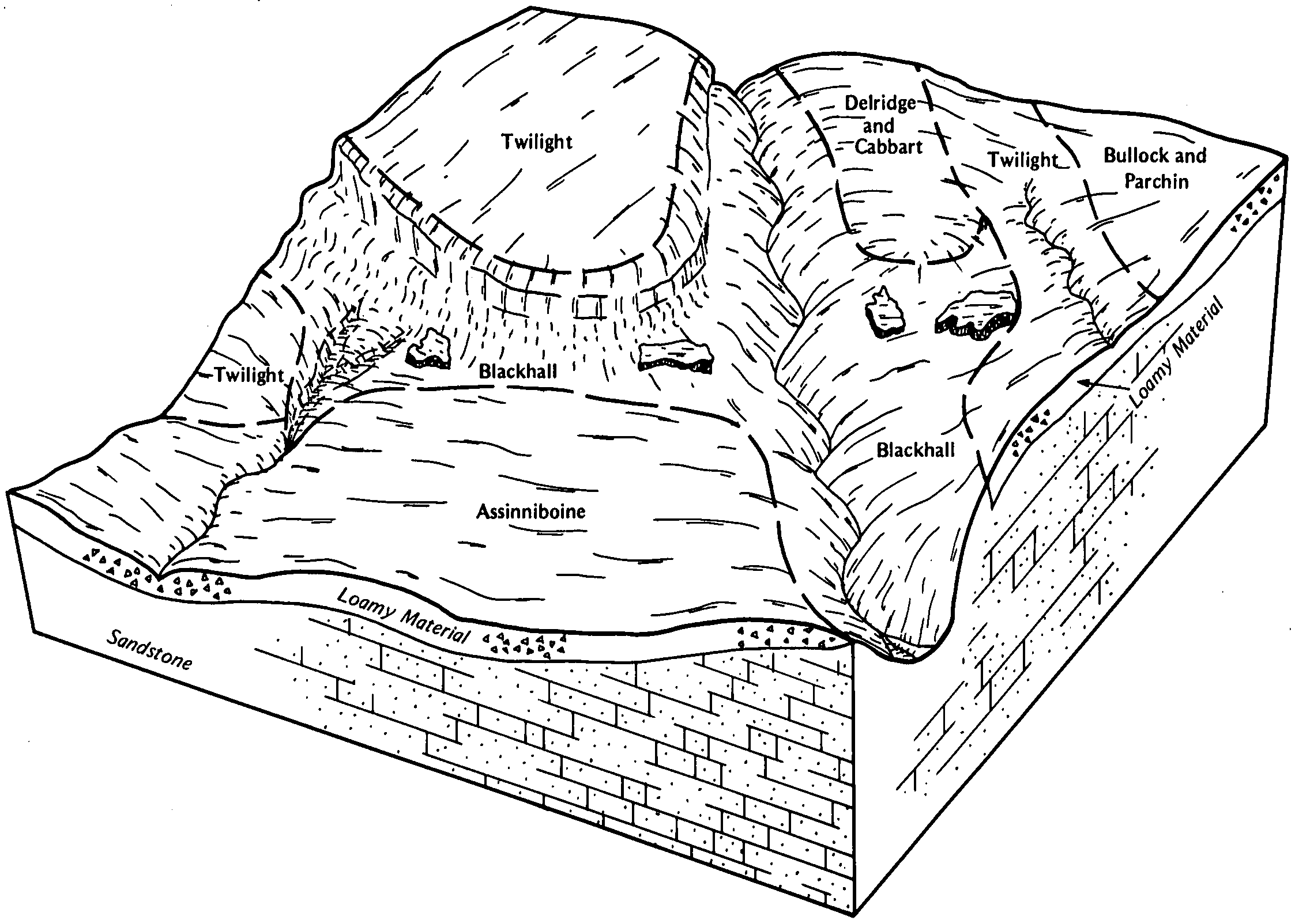
Twilight-Cabbart complex, 8 to 15 percent slopes | 369D | 8008 | 343092 | cj0h | mt011 | 1992 | 1:24000 |
Cambeth-Cabbart silt loams, 2 to 8 percent slopes | 260C | 6036 | 343054 | 2w2cl | mt011 | 1992 | 1:24000 |
Cabbart silt loam, 4 to 15 percent slopes | 60D | 5701 | 343167 | 2yjzx | mt011 | 1992 | 1:24000 |
Cabbart-Bascovy complex, 4 to 15 percent slopes | 360D | 3534 | 343090 | 2yjzv | mt011 | 1992 | 1:24000 |
Cambeth-Cabbart-Yawdim complex, 15 to 25 percent slopes | 260E | 2471 | 343056 | 2vdkl | mt011 | 1992 | 1:24000 |
Kirby-Cabbart complex, 8 to 25 percent slopes | 176D | 1840 | 342970 | chwk | mt011 | 1992 | 1:24000 |
Kremlin-Cabbart complex, 2 to 8 percent slopes | 172C | 1236 | 342962 | chw9 | mt011 | 1992 | 1:24000 |
Yamacall-Delpoint-Cabbart loams, 4 to 15 percent slopes | 586D | 1067 | 343150 | 2w7p9 | mt011 | 1992 | 1:24000 |
Cambeth-Cabbart-Yawdim complex, 15 to 25 percent slopes | 297E | 255774 | 343381 | 2vdkl | mt017 | 1995 | 1:24000 |
Cabbart-Rock outcrop-Yawdim complex, warm, 15 to 70 percent slopes | 3F | 224927 | 343433 | 2tz7m | mt017 | 1995 | 1:24000 |
Cambeth-Cabbart-Rock outcrop complex, 8 to 45 percent slopes | 296F | 57048 | 343378 | 2yk1h | mt017 | 1995 | 1:24000 |
Cabbart-Rock outcrop-Delpoint complex, 15 to 50 percent slopes | 386F | 50023 | 343424 | 2tvlw | mt017 | 1995 | 1:24000 |
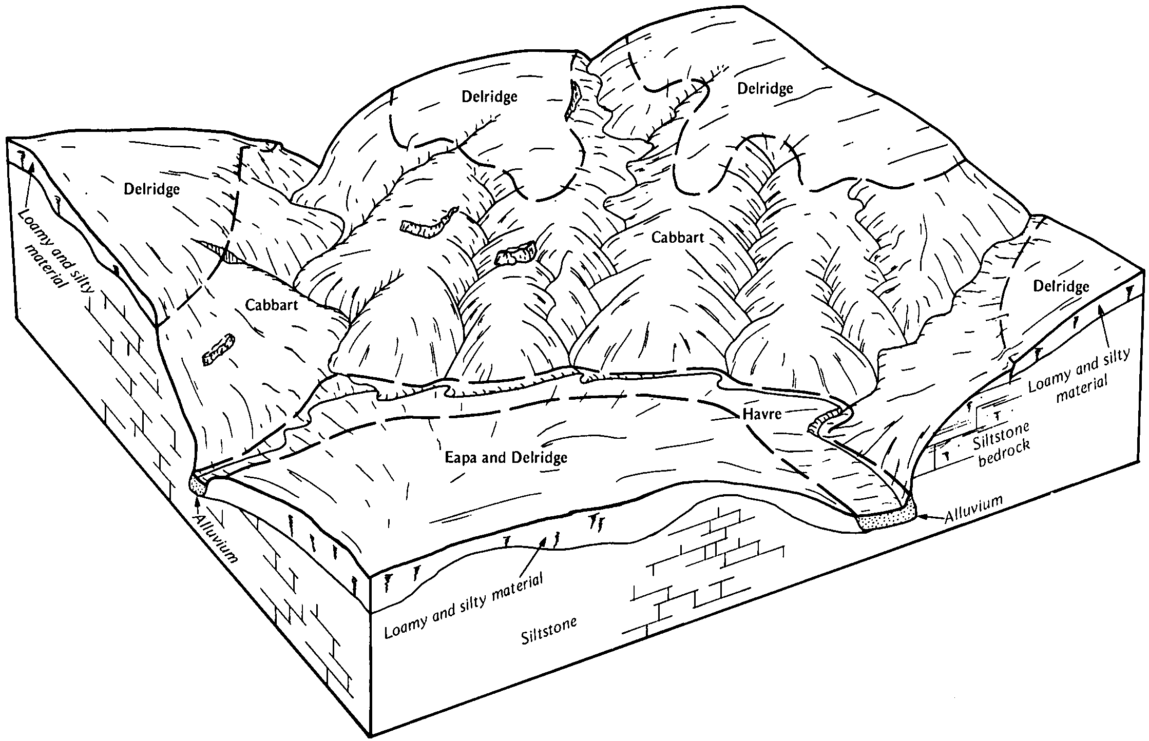
Lonna-Cambeth-Cabbart silt loams, 4 to 12 percent slopes | 577D | 48267 | 343552 | 2tvls | mt017 | 1995 | 1:24000 |
Lonna-Cambeth-Cabbart silt loams, 12 to 25 percent slopes | 574E | 44266 | 343548 | 2tvlx | mt017 | 1995 | 1:24000 |
Delpoint-Cabbart-Yawdim complex, 25 to 70 percent slopes | 383F | 41090 | 343421 | 2tvlz | mt017 | 1995 | 1:24000 |
Delpoint-Yamacall-Cabbart loams, 8 to 25 percent slopes | 385E | 37823 | 343423 | 2vcqn | mt017 | 1995 | 1:24000 |
Cabbart-Havre loams, 0 to 35 percent slopes | 18E | 34342 | 343329 | 2wbys | mt017 | 1995 | 1:24000 |
Yamacall-Delpoint-Cabbart loams, 4 to 15 percent slopes | 892D | 23962 | 343729 | 2w7p9 | mt017 | 1995 | 1:24000 |
Tinsley-Delpoint-Cabbart complex, 8 to 45 percent slope | 123F | 7224 | 343308 | cj7g | mt017 | 1995 | 1:24000 |
Rock outcrop-Cabbart-Kirby complex, 25 to 70 percent slopes | 691F | 5525 | 343649 | cjlg | mt017 | 1995 | 1:24000 |
Cambeth, calcareous-Cabbart-Kirby complex, 8 to 45 percent slopes | 293E | 5022 | 343376 | 2zg5l | mt017 | 1995 | 1:24000 |
Armells-Kirby-Cabbart complex, 25 to 70 percent slopes, stony | 151F | 2766 | 343319 | 2yk03 | mt017 | 1995 | 1:24000 |
Cambeth-Cabbart silt loams, 4 to 15 percent slopes | 917D | 1743 | 343749 | 2w7p7 | mt017 | 1995 | 1:24000 |
Kobase-Cabbart-Yawdim complex, 8 to 25 percent slopes | 944E | 818 | 343766 | cjq7 | mt017 | 1995 | 1:24000 |
Cambeth-Cabbart complex, 8 to 25 percent slopes, dissected | 918E | 656 | 343751 | 2w7p8 | mt017 | 1995 | 1:24000 |
Cambeth, calcareous-Cabbart-Yawdim complex, 4 to 25 percent slopes | 964E | 574 | 343810 | 2zg5n | mt017 | 1995 | 1:24000 |
Kirby-Cabbart-Rock outcrop complex, 25 to 70 percent slopes | 943F | 504 | 343764 | cjq5 | mt017 | 1995 | 1:24000 |
Tinsley-Cabbart complex, 15 to 45 percent slopes | 665F | 407 | 343634 | cjkz | mt017 | 1995 | 1:24000 |
Abor-Cabbart-Delpoint, cacareous complex, 8 to 25 percent slopes | 957E | 397 | 343796 | 2yjzy | mt017 | 1995 | 1:24000 |
Cabbart-Bullock, eroded complex, 2 to 25 percent slopes | 994E | 378 | 343836 | cjsh | mt017 | 1995 | 1:24000 |
Ivanell-Cabbart silt loams, 2 to 8 percent slopes | 581C | 358 | 343556 | cjhg | mt017 | 1995 | 1:24000 |
Armells-Cabbart complex, 25 to 70 percent slopes | 911F | 351 | 343737 | 2yk01 | mt017 | 1995 | 1:24000 |
Armells-Delpoint-Cabbart complex, 25 to 70 percent slopes | 650F | 289 | 343606 | 2yk00 | mt017 | 1995 | 1:24000 |
Delpoint-Cabbart loams, 25 to 70 percent slopes | 919F | 287 | 343753 | cjpt | mt017 | 1995 | 1:24000 |
Cabbart-Cambeth silt loams, 8 to 15 percent slopes | 605D | 191 | 343566 | 2w2cm | mt017 | 1995 | 1:24000 |
Yawdim-Cabbart-Kobase complex, 15 to 70 percent slopes | 956F | 188 | 343794 | cjr4 | mt017 | 1995 | 1:24000 |
Delpoint, moist-Delpoint-Cabbart loams, 15 to 25 percent slopes | 843E | 116 | 343706 | cjn9 | mt017 | 1995 | 1:24000 |
Delpoint-Cabbart-Yawdim complex, 4 to 25 percent slopes | 967E | 75 | 343816 | cjrv | mt017 | 1995 | 1:24000 |
Cambeth, calcareous-Cabbart-Lonna silt loams, 15 to 35 percent slopes | 963E | 73 | 343808 | 2zg5m | mt017 | 1995 | 1:24000 |
Yamacall-Birney-Cabbart complex, 15 to 25 percent slopes | 953E | 67 | 343786 | cjqw | mt017 | 1995 | 1:24000 |
Kremlin-Cabbart complex, 2 to 8 percent slopes | 613C | 52 | 343583 | cjjb | mt017 | 1995 | 1:24000 |
Birney, moist-Armells-Cabbart complex, 25 to 70 percent slopes | 841F | 43 | 343702 | 2yk04 | mt017 | 1995 | 1:24000 |
Cambeth-Cabbart silt loams, 2 to 8 percent slopes | 607C | 27 | 343568 | 2w2cl | mt017 | 1995 | 1:24000 |
Lonna-Cabbart-Yawdim complex, 8 to 25 percent slopes | 947E | 20 | 343776 | cjqk | mt017 | 1995 | 1:24000 |
Lonna-Cambeth-Cabbart silt loams, 4 to 12 percent slopes | 202D | 119613 | 754474 | 2tvls | mt021 | 1971 | 1:24000 |
Lonna-Cambeth-Cabbart silt loams, 12 to 25 percent slopes | 203E | 5946 | 754475 | 2tvlx | mt021 | 1971 | 1:24000 |
Cabbart-Rock outcrop-Delpoint complex, 15 to 50 percent slopes | 160E | 71744 | 342106 | 2tvlw | mt025 | 1991 | 1:24000 |
Cabbart-Cambeth silt loams, 8 to 15 percent slopes | 260D | 56796 | 342175 | 2w2cm | mt025 | 1991 | 1:24000 |
Cambeth-Cabbart silt loams, 2 to 8 percent slopes | 260C | 22313 | 342174 | 2w2cl | mt025 | 1991 | 1:24000 |
Delpoint-Cabbart complex, 8 to 15 percent slopes | 171D | 21987 | 342127 | ch0c | mt025 | 1991 | 1:24000 |
Lonna-Cabbart silt loams, 8 to 25 percent slopes | 293D | 15774 | 3040368 | ch2k | mt025 | 1991 | 1:24000 |
Cabbart silt loam, 4 to 15 percent slopes | 60D | 14245 | 342258 | 2yjzx | mt025 | 1991 | 1:24000 |
Bonfri-Cabbart loams, 8 to 15 percent slopes | 291D | 13273 | 342193 | 2yvmt | mt025 | 1991 | 1:24000 |
Yamacall-Cabbart loams, 15 to 35 percent slopes | 386E | 12993 | 342218 | ch39 | mt025 | 1991 | 1:24000 |
Twilight-Cabbart complex, 8 to 15 percent slopes | 369D | 11243 | 342211 | ch32 | mt025 | 1991 | 1:24000 |
Delpoint-Cabbart complex, 2 to 8 percent slopes | 171C | 9345 | 342126 | ch0b | mt025 | 1991 | 1:24000 |
Kirby-Cabbart complex, 8 to 25 percent slopes | 176D | 9239 | 3040367 | ch0k | mt025 | 1991 | 1:24000 |
Cabbart-Rock outcrop-Yawdim complex, warm, 15 to 70 percent slopes | 160F | 7005 | 342107 | 2tz7m | mt025 | 1991 | 1:24000 |
Lonna-Cambeth-Cabbart silt loams, 4 to 12 percent slopes | 193D | 6115 | 342147 | 2tvls | mt025 | 1991 | 1:24000 |
Kremlin-Cabbart complex, 2 to 8 percent slopes | 172C | 4671 | 342128 | ch0d | mt025 | 1991 | 1:24000 |
Cabbart-Badland complex, 6 to 70 percent slopes | L3107F | 3871 | 2992144 | 2q2n0 | mt025 | 1991 | 1:24000 |
Lonna-Cabbart silt loams, 2 to 8 percent slopes | 293C | 3233 | 342194 | ch2j | mt025 | 1991 | 1:24000 |
Cambeth-Cabbart-Yawdim complex, 15 to 25 percent slopes | 260E | 1691 | 342176 | 2vdkl | mt025 | 1991 | 1:24000 |
Lonna-Cambeth-Cabbart silt loams, 12 to 25 percent slopes | 393E | 1179 | 342221 | 2tvlx | mt025 | 1991 | 1:24000 |
Badland-Cabbart complex, 6 to 70 percent slopes | L3101F | 1073 | 2837973 | 2q1xb | mt025 | 1991 | 1:24000 |
Cabbart-Bascovy complex, 4 to 15 percent slopes | 360D | 1049 | 342209 | 2yjzv | mt025 | 1991 | 1:24000 |
Lonna-Kirby-Cabbart complex, 2 to 50 percent slopes | L3025F | 580 | 342133 | 2q383 | mt025 | 1991 | 1:24000 |
Yamacall-Delpoint-Cabbart loams, 4 to 15 percent slopes | 586D | 111 | 342250 | 2w7p9 | mt025 | 1991 | 1:24000 |
Lonna-Cabbart silt loams, 6 to 35 percent slopes | L3161F | 76 | 342195 | 2q384 | mt025 | 1991 | 1:24000 |
Boxwell-Cabbart loams, 6 to 9 percent slopes | L2601C | 32 | 2876671 | 2qxkk | mt025 | 1991 | 1:24000 |
Marmarth-Cabbart loams, 4 to 8 percent slopes | 163 | 9722 | 342394 | ch8z | mt027 | 1979 | 1:24000 |
Cambeth-Cabbart-Yawdim complex, 15 to 25 percent slopes | 374E | 126726 | 2801049 | 2vdkl | mt033 | 2002 | 1:24000 |
Lonna-Cambeth-Cabbart silt loams, 4 to 12 percent slopes | 702D | 112164 | 342685 | 2tvls | mt033 | 2002 | 1:24000 |
Cabbart, moist-Blacksheep-Delpoint, calcareous complex, 6 to 60 percent slopes | 75E | 87000 | 342787 | 2yk05 | mt033 | 2002 | 1:24000 |
Cabbart-Havre loams, 0 to 35 percent slopes | 941E | 76840 | 342713 | 2wbys | mt033 | 2002 | 1:24000 |
Yamacall-Delpoint-Cabbart loams, 4 to 15 percent slopes | 982D | 74477 | 342720 | 2w7p9 | mt033 | 2002 | 1:24000 |
Cambeth-Cabbart-Rock outcrop complex, 8 to 45 percent slopes | 371F | 58387 | 342633 | 2yk1h | mt033 | 2002 | 1:24000 |
Cambeth-Twilight-Cabbart complex, 4 to 15 percent slopes | 375D | 51197 | 342638 | 2zg5p | mt033 | 2002 | 1:24000 |
Neldore-Cabbart-Blacksheep association, 15 to 60 percent slopes | 1018F | 47634 | 342612 | 2xrs9 | mt033 | 2002 | 1:24000 |
Delpoint-Yamacall-Cabbart loams, 8 to 25 percent slopes | 431E | 44915 | 342651 | 2vcqn | mt033 | 2002 | 1:24000 |
Lonna-Cambeth-Cabbart silt loams, 12 to 25 percent slopes | 372E | 42782 | 342634 | 2tvlx | mt033 | 2002 | 1:24000 |
Cabbart-Rock outcrop-Yawdim complex, warm, 15 to 70 percent slopes | 369F | 42731 | 342750 | 2tz7m | mt033 | 2002 | 1:24000 |
Busby-Twilight-Cabbart association, wooded, 8 to 35 percent slopes | 1017F | 36096 | 342611 | chhz | mt033 | 2002 | 1:24000 |
Cabbart-Delpoint-Cabbart, moist, loams, calcareous 4 to 35 percent slopes | 75D | 29883 | 342789 | 2yk07 | mt033 | 2002 | 1:24000 |
Cabbart-Yawdim complex, 4 to 15 percent slopes | 353D | 18289 | 339944 | 2yk02 | mt033 | 2002 | 1:24000 |
Cambeth-Cabbart silt loams, 2 to 8 percent slopes | 376C | 13283 | 342639 | chjw | mt033 | 2002 | 1:24000 |
Lonna-Cabbart-Cambeth association, 4 to 15 percent slopes | 1022D | 10676 | 342614 | chj2 | mt033 | 2002 | 1:24000 |
Delpoint-Cabbart-Yawdim complex, 25 to 70 percent slopes | 432F | 8452 | 342781 | 2tvlz | mt033 | 2002 | 1:24000 |
Cambeth-Cabbart-Yawdim complex, 4 to 25 percent slopes | 376E | 6601 | 342607 | 2zg5q | mt033 | 2002 | 1:24000 |
Cabbart-Twilight complex, 15 to 45 percent slopes | 352F | 5369 | 339943 | cdqx | mt033 | 2002 | 1:24000 |
Cabbart-Rock outcrop-Delpoint complex, 15 to 50 percent slopes | 362F | 4626 | 342629 | 2tvlw | mt033 | 2002 | 1:24000 |
Delpoint-Cabbart-Yawdim complex, 4 to 25 percent slopes | 435E | 4332 | 342748 | chnd | mt033 | 2002 | 1:24000 |
Yawdim-Rock outcrop, soft-Cabbart association, 15 to 45 percent slopes | 992F | 4292 | 342817 | chqm | mt033 | 2002 | 1:24000 |
Cambeth, calcareous-Cabbart-Kirby complex, 8 to 45 percent slopes | 377E | 2346 | 342641 | 2zg5l | mt033 | 2002 | 1:24000 |
Cambeth-Cabbart silt loams, 4 to 15 percent slopes | 376D | 2196 | 342762 | 2w7p7 | mt033 | 2002 | 1:24000 |
Cambeth-Cabbart-Kirby complex, 4 to 15 percent slopes | 377D | 2028 | 342640 | chjx | mt033 | 2002 | 1:24000 |
Bonfri-Bullock, eroded-Cabbart complex, 4 to 25 percent slopes | 13E | 2028 | 342802 | 2yk11 | mt033 | 2002 | 1:24000 |
Yawdim-Cabbart-Kobase complex, 15 to 70 percent slopes | 991F | 630 | 342796 | chpy | mt033 | 2002 | 1:24000 |
Delpoint-Cabbart loams, 4 to 15 percent slopes | 437D | 522 | 342819 | chqp | mt033 | 2002 | 1:24000 |
Cabbart-Rock outcrop, soft, complex, 15 to 45 percent slopes | 368F | 433 | 342737 | chn1 | mt033 | 2002 | 1:24000 |
Cabbart silt loam, 15 to 25 percent slopes | 36E | 380 | 342632 | 2yjzw | mt033 | 2002 | 1:24000 |
Cambeth-Cabbart complex, 8 to 25 percent slopes, dissected | 379E | 357 | 342818 | 2w7p8 | mt033 | 2002 | 1:24000 |
Yamacall-Cabbart loams, 8 to 25 percent slopes | 989E | 263 | 342758 | chnq | mt033 | 2002 | 1:24000 |
Cambeth-Cabbart silt loams, 8 to 15 percent slopes | 379D | 113 | 342738 | chn2 | mt033 | 2002 | 1:24000 |
Lonna-Cabbart-Yawdim complex, 8 to 25 percent slopes | 708E | 60 | 360657 | d393 | mt033 | 2002 | 1:24000 |
Hillon-Cabbart loams, 15 to 60 percent slopes | 212F | 9378 | 343874 | 2vyrz | mt041 | 1994 | 1:24000 |
Cabbart-Rock outcrop complex, 25 to 60 percent slopes | 211F | 8576 | 343873 | cjtp | mt041 | 1994 | 1:24000 |
Delpoint-Cabbart loams, 2 to 8 percent slopes | 171C | 2030 | 343860 | cjt8 | mt041 | 1994 | 1:24000 |
Cabbart-Yawdim complex, 8 to 25 percent slopes | 213E | 591 | 343875 | cjtr | mt041 | 1994 | 1:24000 |
Hillon-Cabbart loams, 15 to 60 percent slopes | 225F | 7034 | 344157 | 2vyrz | mt051 | 1992 | 1:24000 |
Cabbart-Yawdim-Rock outcrop complex, 25 to 70 percent | 211F | 5881 | 344152 | ck3p | mt051 | 1992 | 1:24000 |
Cabbart-Yawdim complex, 8 to 25 percent slopes | 211E | 2726 | 344151 | ck3n | mt051 | 1992 | 1:24000 |
Delpoint-Cabbart loams, 2 to 8 percent slopes | 171C | 1904 | 344142 | ck3c | mt051 | 1992 | 1:24000 |
Cabbart-Delpoint loams, 8 to 25 percent slopes | 21E | 1250 | 344153 | ck3q | mt051 | 1992 | 1:24000 |
Marvan-Yawdim-Cabbart complex, 4 to 15 percent slopes | 306D | 850 | 344172 | ck4b | mt051 | 1992 | 1:24000 |
Cabbart-Badland complex, 15 to 45 percent slopes | 32 | 45668 | 344394 | ckch | mt055 | 1981 | 1:24000 |
Cambeth-Twilight-Cabbart complex, 4 to 15 percent slopes | 43 | 38058 | 344406 | 2zg5p | mt055 | 1981 | 1:24000 |
Yawdim-Badland-Cabbart association | 165 | 29651 | 344366 | ckbl | mt055 | 1981 | 1:24000 |
Cabbart-Twilight complex, 15 to 45 percent slopes | 34 | 18282 | 344396 | ckck | mt055 | 1981 | 1:24000 |
Cambeth-Cabbart silt loams, 8 to 15 percent slopes | 42 | 17312 | 344405 | ckcv | mt055 | 1981 | 1:24000 |
Cabbart silt loam, 15 to 25 percent slopes | 31 | 16548 | 344393 | 2yjzw | mt055 | 1981 | 1:24000 |
Cabbart-Yawdim complex, 4 to 15 percent slopes | 35 | 10894 | 344397 | 2yk02 | mt055 | 1981 | 1:24000 |
Cabbart-Yawdim complex, 15 to 45 percent slopes | 36 | 8589 | 344398 | 2zg5k | mt055 | 1981 | 1:24000 |
Cabbart-Kirby complex, 8 to 45 percent slopes | 33 | 7423 | 344395 | ckcj | mt055 | 1981 | 1:24000 |
Lonna-Cambeth-Cabbart silt loams, 4 to 12 percent slopes | 178 | 1672 | 361545 | 2tvls | mt055 | 1981 | 1:24000 |
Cabbart-Havre loams, 0 to 35 percent slopes | 177 | 617 | 361546 | 2wbys | mt055 | 1981 | 1:24000 |
Cabbart-Delpoint loams, 4 to 15 percent slopes | 182D | 40599 | 1717988 | 2w7p5 | mt065 | 1996 | 1:24000 |
Cabbart, moist-Delpoint, dry loams, 8 to 45 percent slopes | 287F | 32862 | 344551 | 2yk1c | mt065 | 1996 | 1:24000 |
Cabbart, moist-Delpoint, dry loams, 4 to 15 percent slopes | 280D | 29806 | 344538 | 2yk1b | mt065 | 1996 | 1:24000 |
Cabbart, calcareous-Rock outcrop complex, 8 to 45 percent slopes | 286F | 27318 | 344549 | 2yt5m | mt065 | 1996 | 1:24000 |
Delpoint-Cabbart-Yamacall loams, 4 to 15 percent slopes | 31C | 25787 | 344566 | cgjn | mt065 | 1996 | 1:24000 |
Cabbart-Delpoint, calcareous-Rock outcrop complex, 4 to 15 percent slopes | 82C | 21206 | 344631 | 2yk09 | mt065 | 1996 | 1:24000 |
Cabbart-Delpoint loams, 15 to 65 percent slopes | 288F | 21113 | 344553 | 2yk08 | mt065 | 1996 | 1:24000 |
Delpoint-Cabbart loams, 2 to 8 percent slopes | 81B | 19577 | 344627 | 2w7p6 | mt065 | 1996 | 1:24000 |
Cabbart-Delpoint, calcareous-Rock outcrop complex, 8 to 45 percent slopes | 82E | 17470 | 344632 | 2yk0c | mt065 | 1996 | 1:24000 |
Cabbart-Yawdim-Badland complex, 4 to 35 percent slopes | 84D | 17180 | 344635 | 2zg5z | mt065 | 1996 | 1:24000 |
Delpoint, calcareous-Cabbart-Yamacall, calcareous, loams, 4 to 15 percent slopes | 39C | 14964 | 344580 | 2zg5s | mt065 | 1996 | 1:24000 |
Delpoint, dry-Cabbart, moist loams, 2 to 8 percent slopes | 287D | 11160 | 344550 | 2zg5r | mt065 | 1996 | 1:24000 |
Cabbart-Yawdim-Delpoint complex, 4 to 15 percent slopes | 84C | 9977 | 344634 | 2zg5w | mt065 | 1996 | 1:24000 |
Cabbart, calcareous-Crago-Delpoint, calcareous complex, 8 to 35 percent slopes | 181E | 9463 | 344499 | 2yk0d | mt065 | 1996 | 1:24000 |
Rentsac-Cabbart complex, 2 to 15 percent slopes | 189C | 5841 | 344501 | 2yk1j | mt065 | 1996 | 1:24000 |
Delpoint-Cabbart-Havre loams, 4 to 25 percent slopes | 288D | 5740 | 344552 | ckjl | mt065 | 1996 | 1:24000 |
Cabbart-Rock outcrop-Blacksheep complex, 8 to 45 percent slopes | 83D | 5453 | 344633 | 2xb4d | mt065 | 1996 | 1:24000 |
Cabbart-Crago-Delpoint complex, 4 to 15 percent slopes | 181D | 5316 | 344498 | 2zg5v | mt065 | 1996 | 1:24000 |
Delpoint, calcareous-Cabbart loams, 2 to 8 percent slopes | 87B | 5013 | 344640 | 2zg60 | mt065 | 1996 | 1:24000 |
Bonfri-Cabbart loams, 2 to 8 percent slopes | 354C | 2922 | 1715945 | 2yk18 | mt065 | 1996 | 1:24000 |
Cabbart-Rock outcrop complex, 4 to 35 percent slopes | 86E | 2125 | 344639 | cglk | mt065 | 1996 | 1:24000 |
Cabbart-Bonfri loams, 4 to 15 percent slopes | 354D | 1431 | 1715946 | 2yt5n | mt065 | 1996 | 1:24000 |
Cabbart-Blacksheep, dry- complex, 8 to 25 percent slopes | 183E | 1362 | 1913586 | 2xg18 | mt065 | 1996 | 1:24000 |
Cabbart-Tanna loams, 4 to 15 percent slopes | 153D | 1269 | 344488 | ckgj | mt065 | 1996 | 1:24000 |
Tanna-Cabbart loams, 2 to 8 percent slopes | 153C | 1112 | 344487 | cghy | mt065 | 1996 | 1:24000 |
Cabbart-Delpoint loams, moist, 4 to 45 percent slopes | 880F | 856 | 1713822 | 2yk1m | mt065 | 1996 | 1:24000 |
Cabbart clay loam, 0 to 2 percent slopes | 85A | 682 | 344637 | ckmb | mt065 | 1996 | 1:24000 |
Bonfri-Cabbart loams, 0 to 4 percent slopes | 354B | 356 | 1887082 | 2yk17 | mt065 | 1996 | 1:24000 |
Cabbart, dry-Delpoint, dry-Rock outcrop complex, 8 to 65 percent slopes | 881F | 207 | 1713823 | 2yk1d | mt065 | 1996 | 1:24000 |
Delpoint-Cabbart loams, dry, 4 to 15 percent slopes | 880D | 78 | 1713821 | nvc4 | mt065 | 1996 | 1:24000 |
Cabbart-Yamacall-Havre, rarely flooded, loams, 2 to 60 percent slopes | 780F | 14 | 1713820 | d0sr | mt065 | 1996 | 1:24000 |
Cabbart, moist-Blacksheep-Delpoint, calcareous complex, 6 to 60 percent slopes | 23 | 40853 | 344689 | 2yk05 | mt069 | 1989 | 1:24000 |
Cabbart-Yawdim-Rock outcrop complex, 4 to 35 percent slopes | 21 | 36866 | 2837652 | 2zg5y | mt069 | 1989 | 1:24000 |
Delpoint-Cabbart-Yamac loams, 4 to 15 percent slopes | 32 | 34026 | 344699 | ckpb | mt069 | 1989 | 1:24000 |
Cabbart-Delpoint-Cabbart, moist, loams, calcareous 4 to 35 percent slopes | 17 | 21092 | 344682 | 2yk07 | mt069 | 1989 | 1:24000 |
Cabbart-Delpoint loams, 4 to 15 percent slopes | 16 | 11830 | 344681 | 2w7p5 | mt069 | 1989 | 1:24000 |
Cabbart-Delpoint, calcareous-Rock outcrop complex, 8 to 45 percent slopes | 18 | 9541 | 344683 | 2yk0c | mt069 | 1989 | 1:24000 |
Delpoint-Cabbart loams, 2 to 8 percent slopes | 31 | 7386 | 344698 | 2w7p6 | mt069 | 1989 | 1:24000 |
Cabbart, calcareous-Crago-Delpoint, calcareous complex, 8 to 35 percent slopes | 15 | 6790 | 344680 | 2yk0d | mt069 | 1989 | 1:24000 |
Cabbart-Rock outcrop-Blacksheep complex, 8 to 45 percent slopes | 19 | 6418 | 344684 | 2xb4d | mt069 | 1989 | 1:24000 |
Cabbart-Yawdim-Delpoint complex, 15 to 35 percent slopes | 20 | 5441 | 344686 | 2zg5x | mt069 | 1989 | 1:24000 |
Cabbart, high precipitation-Cabbart, moist, complex, 15 to 60 percent slopes | 22 | 2306 | 344688 | cknz | mt069 | 1989 | 1:24000 |
Cabbart loam, 8 to 15 percent slopes | 14 | 975 | 344679 | cknp | mt069 | 1989 | 1:24000 |
Lonna-Cambeth-Cabbart silt loams, 4 to 12 percent slopes | 90 | 123278 | 345046 | 2tvls | mt079 | 1986 | 1:24000 |
Lonna-Cambeth-Cabbart silt loams, 12 to 25 percent slopes | 91 | 110112 | 345047 | 2tvlx | mt079 | 1986 | 1:24000 |
Cabbart-Rock outcrop-Yawdim complex, warm, 15 to 70 percent slopes | 20 | 48721 | 344835 | 2tz7m | mt079 | 1986 | 1:24000 |
Cambeth, calcareous-Cabbart-Yawdim complex, 4 to 25 percent slopes | 27 | 24256 | 344847 | 2zg5n | mt079 | 1986 | 1:24000 |
Cambeth, calcareous-Cabbart-Lonna silt loams, 15 to 35 percent slopes | 26 | 20119 | 344846 | 2zg5m | mt079 | 1986 | 1:24000 |
Cambeth, calcareous-Cabbart-Kirby complex, 8 to 45 percent slopes | 25 | 15595 | 344845 | 2zg5l | mt079 | 1986 | 1:24000 |
Delpoint-Yamacall-Cabbart loams, 8 to 25 percent slopes | 47 | 14906 | 344926 | 2vcqn | mt079 | 1986 | 1:24000 |
Delpoint-Cabbart-Yawdim complex, 25 to 70 percent slopes | 46 | 13989 | 344923 | 2tvlz | mt079 | 1986 | 1:24000 |
Cabbart-Cambeth-Rock outcrop, soft complex, 8 to 70 percent slopes | 149 | 13402 | 2451187 | 2n8nk | mt079 | 1986 | 1:24000 |
Abor-Cabbart-Delpoint, cacareous complex, 8 to 25 percent slopes | 1 | 12828 | 344774 | 2yjzy | mt079 | 1986 | 1:24000 |
Tinsley-Delpoint-Cabbart complex, 8 to 45 percent slopes | 122 | 11198 | 344801 | cksm | mt079 | 1986 | 1:24000 |
Cabbart-Havre loams, 0 to 35 percent slopes | 142 | 10901 | 361539 | 2wbys | mt079 | 1986 | 1:24000 |
Delpoint-Cabbart-Yawdim complex, 4 to 25 percent slopes | 45 | 9845 | 344919 | ckxf | mt079 | 1986 | 1:24000 |
Yamacall-Delpoint-Cabbart loams, 4 to 15 percent slopes | 137 | 9471 | 344818 | 2w7p9 | mt079 | 1986 | 1:24000 |
Cambeth-Twilight-Cabbart complex, 4 to 15 percent slopes | 150 | 5284 | 2451188 | 2zg5p | mt079 | 1986 | 1:24000 |
Rock outcrop-Cabbart-Kirby complex, 25 to 70 percent slopes | 109 | 3623 | 344785 | cks3 | mt079 | 1986 | 1:24000 |
Delpoint-Cabbart loams, 4 to 15 percent slopes | 44 | 1870 | 344915 | ckx9 | mt079 | 1986 | 1:24000 |
Lonna-Busby-Cabbart complex, 8 to 25 percent slopes | 156 | 1432 | 2451200 | 2n8nz | mt079 | 1986 | 1:24000 |
Lonna-Cambeth-Cabbart silt loams, 4 to 12 percent slopes | 202D | 62364 | 1677546 | 2tvls | mt083 | 1973 | 1:24000 |
Cabbart-Rock outcrop complex, 25 to 70 percent slopes | 211F | 2930 | 345095 | cl33 | mt101 | 1992 | 1:24000 |
Hillon-Cabbart loams, 15 to 60 percent slopes | 212F | 2000 | 345096 | 2vyrz | mt101 | 1992 | 1:24000 |
Cabbart-Delpoint loams, 8 to 25 percent slopes | 213E | 705 | 345097 | cl35 | mt101 | 1992 | 1:24000 |
Delpoint-Cabbart clay loams, 25 to 60 percent slopes | 171F | 590 | 345079 | cl2l | mt101 | 1992 | 1:24000 |
Bonfri-Beenom-Cabbart loams, 2 to 8 percent | Cx | 4670 | 345412 | 2zg52 | mt103 | 1961 | 1:20000 |
Cabbart-Blacksheep-Rock outcrop complex, 30 to 70 percent slopes | Tr | 3305 | 345511 | 2zg54 | mt103 | 1961 | 1:20000 |
Cabbart-Bonfri loams, 2 to 8 percent slopes | 453C | 1131 | 1946669 | 2yk0j | mt103 | 1961 | 1:20000 |
Cabbart-Delpoint loams, 4 to 15 percent slopes | 182D | 359 | 1946667 | 2w7p5 | mt103 | 1961 | 1:20000 |
Bonfri-Cabbart loams, 0 to 4 percent slopes | 354B | 142 | 1946668 | 2yk17 | mt103 | 1961 | 1:20000 |
Hillon-Cabbart loams, 15 to 60 percent slopes | 6 | 109767 | 345578 | 2vyrz | mt105 | 1976 | 1:24000 |
Marmarth-Cabbart loams, 5 to 25 percent slopes | 39 | 48889 | 345555 | clky | mt105 | 1976 | 1:24000 |
Lonna-Cabbart silt loams, 6 to 35 percent slopes | L3161F | 17885 | 345609 | 2q384 | mt109 | 1956 | 1:31680 |
Lonna-Cambeth-Cabbart silt loams, 4 to 12 percent slopes | 202D | 908 | 1607267 | 2tvls | mt109 | 1956 | 1:31680 |
Lonna-Kirby-Cabbart complex, 2 to 50 percent slopes | L3025F | 373 | 345612 | 2q383 | mt109 | 1956 | 1:31680 |
Blacksheep, dry-Cabbart, dry-Rock outcrop, complex, 8 to 60 percent slopes | 285F | 88190 | 1897375 | 2xg17 | mt111 | 1966 | 1:20000 |
Delpoint-Cabbart loams, 2 to 8 percent slopes | 81B | 60812 | 1869303 | 2w7p6 | mt111 | 1966 | 1:20000 |
Cabbart-Delpoint loams, 4 to 15 percent slopes | 182D | 57219 | 1869328 | 2w7p5 | mt111 | 1966 | 1:20000 |
Cabbart-Bonfri loams, 2 to 8 percent slopes | 453C | 29411 | 1883531 | 2yk0j | mt111 | 1966 | 1:20000 |
Bonfri-Cabbart loams, 0 to 4 percent slopes | 354B | 27714 | 1869336 | 2yk17 | mt111 | 1966 | 1:20000 |
Cabbart-Blacksheep, dry- complex, 8 to 25 percent slopes | 183E | 22197 | 1904087 | 2xg18 | mt111 | 1966 | 1:20000 |
Cabbart-Blacksheep complex, 4 to 15 percent slopes | 282D | 21787 | 1901405 | 2xb4b | mt111 | 1966 | 1:20000 |
Cabbart-Blacksheep complex, 8 to 25 percent slopes | 383E | 11296 | 1904088 | 2xb49 | mt111 | 1966 | 1:20000 |
Rentsac-Cabbart complex, 2 to 15 percent slopes | 189C | 2287 | 1898095 | 2yk1j | mt111 | 1966 | 1:20000 |
Cabbart, moist-Delpoint, dry loams, 4 to 15 percent slopes | 280D | 2185 | 1904531 | 2yk1b | mt111 | 1966 | 1:20000 |
Cabbart, moist-Delpoint, dry loams, 8 to 45 percent slopes | 287F | 1759 | 1913573 | 2yk1c | mt111 | 1966 | 1:20000 |
Cabbart-Rock outcrop-Blacksheep complex, 8 to 45 percent slopes | 83D | 927 | 1913559 | 2xb4d | mt111 | 1966 | 1:20000 |
Delpoint, calcareous-Cabbart loams, 2 to 8 percent slopes | 87B | 647 | 1913562 | 2zg60 | mt111 | 1966 | 1:20000 |
Cabbart, calcareous-Rock outcrop complex, 8 to 45 percent slopes | 286F | 213 | 1913572 | 2yt5m | mt111 | 1966 | 1:20000 |
Cabbart-Yawdim-Delpoint complex, 4 to 15 percent slopes | 84C | 61 | 1913560 | 2zg5w | mt111 | 1966 | 1:20000 |
Cabbart-Yawdim-Badland complex, 4 to 35 percent slopes | 84D | 53 | 1913561 | 2zg5z | mt111 | 1966 | 1:20000 |
Bonfri-Cabbart loams, 2 to 8 percent slopes | 354C | 31 | 1913844 | 2yk18 | mt111 | 1966 | 1:20000 |
Cabbart-Yamacall-Havre, rarely flooded, loams, 2 to 60 percent slopes | 780F | 7 | 1946665 | d0sr | mt111 | 1966 | 1:20000 |
Kalsted-Scravo, stony-Cabbart complex, 15 to 45 percent slopes | 335E | 7339 | 148189 | 4z69 | mt604 | 2001 | 1:24000 |
Varney-Kalsted, stony-Cabbart, stony complex, 4 to 15 percent slopes | 533D | 2888 | 148180 | 4z60 | mt604 | 2001 | 1:24000 |
Scravo, stony-Kalsted-Cabbart complex, 15 to 45 percent slopes | 25E | 1476 | 609124 | nfv5 | mt604 | 2001 | 1:24000 |
Cabbart, very stony-Rentsac, bouldery-Rock outcrop complex, 15 to 45 percent slopes | 198E | 785 | 148252 | 4z8b | mt604 | 2001 | 1:24000 |
Blacksheep, dry-Cabbart, dry-Rock outcrop, complex, 8 to 60 percent slopes | 285F | 605 | 1946527 | 2xg17 | mt607 | 1970 | 1:24000 |
Cabbart-Blacksheep, dry- complex, 8 to 25 percent slopes | 183E | 92 | 2432430 | 2xg18 | mt607 | 1970 | 1:24000 |
Delpoint-Cabbart loams, 2 to 8 percent slopes | 81B | 75 | 1946524 | 2w7p6 | mt607 | 1970 | 1:24000 |
Cabbart-Blacksheep complex, 8 to 25 percent slopes | 383E | 12 | 2432432 | 2xb49 | mt607 | 1970 | 1:24000 |
Badland | 6 | 47278 | 346505 | cmkl | mt608 | 1976 | 1:24000 |
Cabbart-Rock outcrop, shale complex, 25 to 60 percent slopes | 27 | 43270 | 346403 | cmg9 | mt608 | 1976 | 1:24000 |
Hillon-Cabbart loams, 15 to 60 percent slopes | 26 | 28843 | 346398 | 2vyrz | mt608 | 1976 | 1:24000 |
Cabbart-Delpoint loams, 8 to 35 percent slopes | 25 | 23777 | 346396 | cmg2 | mt608 | 1976 | 1:24000 |
Delpoint-Cabbart loams, 2 to 8 percent slopes | 38 | 11639 | 346447 | cmhq | mt608 | 1976 | 1:24000 |
Cabbart-Yamac-Rock outcrop complex, 15 to 70 percent slopes | 28 | 6581 | 346405 | cmgc | mt608 | 1976 | 1:24000 |
Marmarth-Cabbart complex, 2 to 8 percent slopes | 85 | 5737 | 346552 | cmm3 | mt608 | 1976 | 1:24000 |
Cabbart complex, 9 to 35 percent slopes | CaE | 11401 | 147493 | 4ygv | mt609 | 1971 | 1:24000 |
Cabbart-Shoddy-Amesha complex, 8 to 15 percent slopes | 191D | 197 | 147593 | 4yl2 | mt609 | 1971 | 1:24000 |
Cabbart-Shoddy-Amesha complex, 15 to 45 percent slopes | 191E | 160 | 147594 | 4yl3 | mt609 | 1971 | 1:24000 |
Walbert-Shoddy-Cabbart complex, 2 to 15 percent slopes | 851D | 16 | 147626 | 4ym4 | mt609 | 1971 | 1:24000 |
Cabbart-Amesha-Trimad complex, 15 to 45 percent slopes | 710E | 14 | 147673 | 4ynn | mt609 | 1971 | 1:24000 |
Cabbart-Shoddy-Amesha complex, 2 to 8 percent slopes | 191C | 7 | 147592 | 4yl1 | mt609 | 1971 | 1:24000 |
Kalsted-Scravo, stony-Cabbart complex, 15 to 45 percent slopes | 335E | 98 | 2597665 | 4z69 | mt612 | 2011 | 1:24000 |
Yawdim-Rentsac-Cabbart complex, 15 to 50 percent slopes | 231 | 21688 | 341903 | cgs4 | mt613 | 1975 | 1:24000 |

