| Blacksheep-Twilight fine sandy loams, complex, 8 to 15 percent slopes | 55D | 20870 | 343143 | 2wbz0 | mt011 | 1992 | 1:24000 |
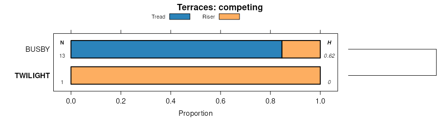
Busby-Twilight-Blacksheep fine sandy loams, 8 to 35 percent slopes | 170D | 14934 | 342956 | 2wbyy | mt011 | 1992 | 1:24000 |
Twilight-Blacksheep fine sandy loams, 15 to 45 percent slopes | 55E | 13707 | 343144 | 2wbz1 | mt011 | 1992 | 1:24000 |
Twilight-Bonfri complex, 8 to 15 percent slopes | 269D | 13608 | 343060 | 2yk10 | mt011 | 1992 | 1:24000 |
Twilight fine sandy loam, 8 to 15 percent slopes | 69D | 12752 | 343212 | cj4c | mt011 | 1992 | 1:24000 |
Rentsac-Twilight-Rock outcrop complex, 15 to 45 percent slopes | 99F | 8894 | 343298 | cj74 | mt011 | 1992 | 1:24000 |
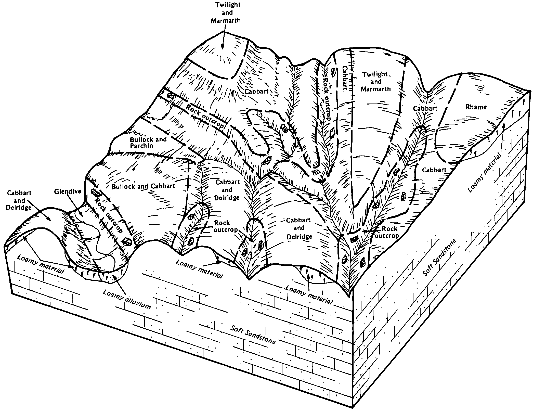
Twilight-Cabbart complex, 8 to 15 percent slopes | 369D | 8008 | 343092 | cj0h | mt011 | 1992 | 1:24000 |
Twilight-Bonfri complex, 2 to 8 percent slopes | 269C | 6920 | 343059 | 2yk0z | mt011 | 1992 | 1:24000 |
Twilight fine sandy loam, 2 to 8 percent slopes | 69C | 5060 | 343211 | cj4b | mt011 | 1992 | 1:24000 |
Twilight-Delpoint complex, 2 to 8 percent slopes | 369C | 2268 | 343091 | cj0g | mt011 | 1992 | 1:24000 |
Chinook-Twilight fine sandy loams, 2 to 12 percent slopes | 352D | 26234 | 343400 | cjbf | mt017 | 1995 | 1:24000 |
Busby-Twilight fine sandy loams, 2 to 15 percent slopes | 277D | 20911 | 343363 | cj97 | mt017 | 1995 | 1:24000 |
Busby-Twilight-Blacksheep fine sandy loams, 8 to 35 percent slopes | 271E | 16317 | 343356 | 2wbyy | mt017 | 1995 | 1:24000 |
Chinook-Twilight-Eapa complex, 2 to 8 percent slopes | 355C | 13563 | 343403 | cjbj | mt017 | 1995 | 1:24000 |
Twilight-Blacksheep-Busby fine sandy loams, 8 to 45 percent slopes | 921F | 6513 | 343755 | cjpw | mt017 | 1995 | 1:24000 |
Chinook-Lihill-Twilight complex, 8 to 15 percent slopes | 357D | 4580 | 343404 | cjbk | mt017 | 1995 | 1:24000 |
Chinook-Twilight fine sandy loams, 2 to 8 percent slopes | 965C | 525 | 343812 | cjrq | mt017 | 1995 | 1:24000 |
Chinook-Twilight-Blacksheep fine sandy loams, 8 to 15 percent slopes | 966D | 433 | 343814 | cjrs | mt017 | 1995 | 1:24000 |
Busby-Twilight-Blacksheep fine sandy loams, 2 to 8 percent slopes | 651C | 9 | 343608 | cjk4 | mt017 | 1995 | 1:24000 |
Twilight-Yetull complex, 8 to 25 percent slopes | Dc | 19090 | 342007 | cgwh | mt021 | 1971 | 1:24000 |
Twilight-Yetull complex, 2 to 8 percent slopes | Db | 6182 | 342006 | cgwg | mt021 | 1971 | 1:24000 |
Twilight fine sandy loam, 2 to 8 percent slopes | Da | 4322 | 342005 | cgwf | mt021 | 1971 | 1:24000 |
Blacksheep-Twilight fine sandy loams, complex, 8 to 15 percent slopes | 55D | 17117 | 342245 | 2wbz0 | mt025 | 1991 | 1:24000 |
Busby-Twilight-Blacksheep fine sandy loams, 8 to 35 percent slopes | 170D | 14418 | 342124 | 2wbyy | mt025 | 1991 | 1:24000 |
Twilight-Cabbart complex, 8 to 15 percent slopes | 369D | 11243 | 342211 | ch32 | mt025 | 1991 | 1:24000 |
Twilight fine sandy loam, 2 to 8 percent slopes | 69C | 6040 | 342272 | ch51 | mt025 | 1991 | 1:24000 |
Twilight fine sandy loam, 8 to 15 percent slopes | 69D | 5364 | 342273 | ch52 | mt025 | 1991 | 1:24000 |
Twilight-Blacksheep fine sandy loams, 15 to 45 percent slopes | 55E | 4925 | 2942846 | 2wbz1 | mt025 | 1991 | 1:24000 |
Twilight-Delpoint complex, 2 to 8 percent slopes | 369C | 4791 | 342210 | ch31 | mt025 | 1991 | 1:24000 |
Twilight-Bonfri complex, 8 to 15 percent slopes | 269D | 2663 | 342180 | 2yk10 | mt025 | 1991 | 1:24000 |
Twilight-Bonfri complex, 2 to 8 percent slopes | 269C | 2573 | 342179 | 2yk0z | mt025 | 1991 | 1:24000 |
Busby-Twilight-Blacksheep fine sandy loams, 8 to 35 percent slopes | 314E | 65037 | 342624 | 2wbyy | mt033 | 2002 | 1:24000 |
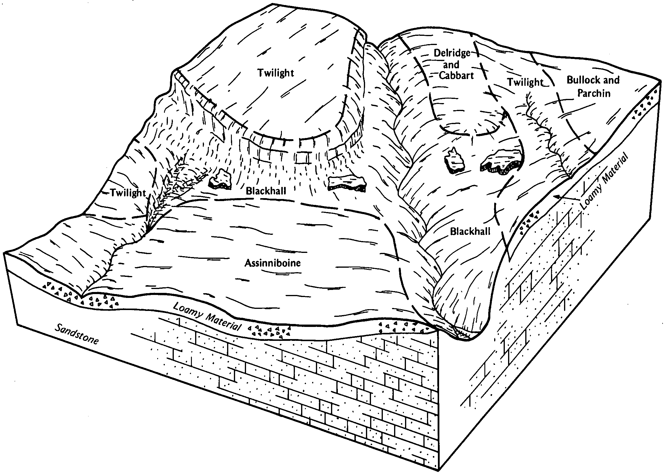
Cambeth-Twilight-Cabbart complex, 4 to 15 percent slopes | 375D | 51197 | 342638 | 2zg5p | mt033 | 2002 | 1:24000 |
Chinook-Twilight fine sandy loams, 2 to 15 percent slopes | 382D | 45023 | 342643 | chk0 | mt033 | 2002 | 1:24000 |
Twilight-Blacksheep fine sandy loams, 15 to 45 percent slopes | 316F | 39557 | 342626 | 2wbz1 | mt033 | 2002 | 1:24000 |
Busby-Twilight-Cabbart association, wooded, 8 to 35 percent slopes | 1017F | 36096 | 342611 | chhz | mt033 | 2002 | 1:24000 |
Chinook-Twilight-Eapa complex, 2 to 8 percent slopes | 383C | 32667 | 342644 | chk1 | mt033 | 2002 | 1:24000 |
Busby-Blacksheep-Twilight fine sandy loams, 2 to 15 percent slopes | 311D | 17409 | 342622 | chjb | mt033 | 2002 | 1:24000 |
Busby-Twilight fine sandy loams, 2 to 15 percent slopes | 313D | 12351 | 342623 | chjc | mt033 | 2002 | 1:24000 |
Cabbart-Twilight complex, 15 to 45 percent slopes | 352F | 5369 | 339943 | cdqx | mt033 | 2002 | 1:24000 |
Yamacall-Twilight-Blacksheep complex, 8 to 15 percent slopes | 983D | 4504 | 342721 | chmj | mt033 | 2002 | 1:24000 |
Busby-Twilight-Fleak complex, 8 to 15 percent slopes | 318D | 734 | 342736 | chn0 | mt033 | 2002 | 1:24000 |
Yamacall-Twilight-Fleak complex, 8 to 15 percent slopes | 987D | 507 | 342816 | chql | mt033 | 2002 | 1:24000 |
Yamacall-Twilight complex, 2 to 8 percent slopes | 986C | 355 | 342815 | chqk | mt033 | 2002 | 1:24000 |
Busby-Twilight-Blacksheep fine sandy loams, 2 to 8 percent slopes | 317C | 307 | 342779 | chpd | mt033 | 2002 | 1:24000 |
Twilight-Yetull fine sandy loams, 8 to 15 percent slopes | 916D | 222 | 339751 | cdjq | mt033 | 2002 | 1:24000 |
Busby-Twilight fine sandy loams, 2 to 8 percent slopes | 319C | 79 | 339741 | cdjd | mt033 | 2002 | 1:24000 |
Busby-Twilight-Blacksheep fine sandy loams, 4 to 15 percent slopes | 314D | 22 | 342747 | chnc | mt033 | 2002 | 1:24000 |
Twilight-Blacksheep fine sandy loams, 2 to 8 percent slopes | 661C | 2894 | 344022 | cjzh | mt041 | 1994 | 1:24000 |
Twilight-Blacksheep fine sandy loams, 2 to 8 percent slopes | 661C | 218 | 344241 | ck6k | mt051 | 1992 | 1:24000 |
Cambeth-Twilight-Cabbart complex, 4 to 15 percent slopes | 43 | 38058 | 344406 | 2zg5p | mt055 | 1981 | 1:24000 |
Cabbart-Twilight complex, 15 to 45 percent slopes | 34 | 18282 | 344396 | ckck | mt055 | 1981 | 1:24000 |
Busby-Twilight-Fleak complex, 8 to 15 percent slopes | 22 | 14766 | 344383 | ckc4 | mt055 | 1981 | 1:24000 |
Yamacall-Twilight-Fleak complex, 8 to 15 percent slopes | 163 | 8005 | 344364 | ckbj | mt055 | 1981 | 1:24000 |
Yamacall-Twilight complex, 2 to 8 percent slopes | 162 | 5717 | 344363 | ckbh | mt055 | 1981 | 1:24000 |
Twilight-Yetull fine sandy loams, 8 to 15 percent slopes | 142 | 4551 | 344341 | ck9s | mt055 | 1981 | 1:24000 |
Busby-Twilight fine sandy loams, 2 to 8 percent slopes | 21 | 3391 | 344382 | ckc3 | mt055 | 1981 | 1:24000 |
Twilight-Blacksheep sandy loams, 2 to 8 percent slopes | 132B | 15199 | 344475 | 2xrsb | mt065 | 1996 | 1:24000 |
Blacksheep-Twilight sandy loams, 8 to 45 percent slopes | 243F | 9836 | 344519 | ckhj | mt065 | 1996 | 1:24000 |
Twilight-Blacksheep-Rock outcrop complex, 4 to 35 percent slopes | 241E | 9257 | 344516 | ckhf | mt065 | 1996 | 1:24000 |
Twilight-Blacksheep-Rock outcrop, complex, 4 to 25 percent slopes | 32D | 7022 | 344568 | cgjq | mt065 | 1996 | 1:24000 |
Twilight sandy loam, 2 to 8 percent slopes | 32B | 3422 | 344567 | cgjp | mt065 | 1996 | 1:24000 |
Blacksheep-Rock outcrop-Twilight complex, 8 to 45 percent slopes | 80E | 1046 | 344626 | cgl5 | mt065 | 1996 | 1:24000 |
Blacksheep-Twilight complex, 4 to 25 percent slopes | 83E | 281 | 1913584 | 21r6c | mt065 | 1996 | 1:24000 |
Busby-Twilight fine sandy loams, 2 to 8 percent slopes | 130B | 105 | 360767 | pl25 | mt065 | 1996 | 1:24000 |
Twilight-Blacksheep sandy loams, 2 to 8 percent slopes | 79 | 17588 | 344750 | 2xrsb | mt069 | 1989 | 1:24000 |
Twilight-Blackhall-Rock outcrop complex, 4 to 25 percent slopes | 80 | 11903 | 344752 | ckr1 | mt069 | 1989 | 1:24000 |
Busby-Twilight fine sandy loams, 2 to 8 percent slopes | 13 | 6701 | 344678 | pl25 | mt069 | 1989 | 1:24000 |
Blackhall-Rock outcrop-Twilight complex, 8 to 45 percent slopes | 10 | 5021 | 344670 | cknd | mt069 | 1989 | 1:24000 |
Twilight sandy loam, 2 to 8 percent slopes | 78 | 1233 | 344749 | ckqy | mt069 | 1989 | 1:24000 |
Chinook-Twilight fine sandy loams, 2 to 8 percent slopes | 37 | 6095 | 344892 | ckwk | mt079 | 1986 | 1:24000 |
Chinook-Twilight-Blackhall fine sandy loams, 8 to 15 percent slopes | 38 | 5310 | 344893 | ckwl | mt079 | 1986 | 1:24000 |
Cambeth-Twilight-Cabbart complex, 4 to 15 percent slopes | 150 | 5284 | 2451188 | 2zg5p | mt079 | 1986 | 1:24000 |
Busby-Blackhall-Twilight fine sandy loams, 8 to 25 percent slopes | 15 | 4704 | 344826 | cktf | mt079 | 1986 | 1:24000 |
Busby-Twilight-Blackhall fine sandy loams, 4 to 15 percent slopes | 16 | 4320 | 344827 | cktg | mt079 | 1986 | 1:24000 |
Yetull-Twilight complex, 4 to 15 percent slopes | 161 | 1114 | 2451205 | 2n8p4 | mt079 | 1986 | 1:24000 |
Blacksheep-Twilight fine sandy loams, 15 to 40 percent slopes | Tp | 10011 | 345510 | 2zg59 | mt103 | 1961 | 1:20000 |
Blacksheep-Twilight complex, 4 to 25 percent slopes | 83E | 9 | 1946666 | 23bnp | mt103 | 1961 | 1:20000 |
Blacksheep-Twilight complex, 4 to 25 percent slopes | 83E | 27410 | 1899133 | 21r6c | mt111 | 1966 | 1:20000 |
Twilight-Blacksheep-Rock outcrop, complex, 4 to 25 percent slopes | 32D | 99 | 1913542 | cgjq | mt111 | 1966 | 1:20000 |
Twilight sandy loam, 2 to 8 percent slopes | 32B | 10 | 1946663 | cgjp | mt111 | 1966 | 1:20000 |
Blacksheep-Twilight complex, 4 to 25 percent slopes | 83E | 90 | 2432431 | 2mn4j | mt607 | 1970 | 1:24000 |
Twilight-Riedel fine sandy loams, 8 to 20 percent slopes | 128 | 3084 | 346282 | cmbd | mt608 | 1976 | 1:24000 |
Twilight-Riedel fine sandy loams, 4 to 8 percent slopes | 127 | 2801 | 346281 | cmbc | mt608 | 1976 | 1:24000 |
Twilight-Fleak complex, 8 to 25 percent slopes | 661E | 7429 | 346875 | cmyj | mt615 | 1992 | 1:24000 |
Fleak-Twilight-Rock outcrop complex, 25 to 70 percent slopes | 654F | 6744 | 346873 | cmyg | mt615 | 1992 | 1:24000 |
Fleak-Twilight-Yetull complex, 25 to 70 percent slopes | 653F | 4942 | 346872 | cmyf | mt615 | 1992 | 1:24000 |
Busby-Twilight fine sandy loams, 4 to 15 percent slopes | 941D | 3862 | 346986 | cn23 | mt615 | 1992 | 1:24000 |
Twilight-Blacksheep sandy loams, 2 to 8 percent slopes | 132B | 4100 | 3176860 | 2xrsb | mt624 | 2021 | 1:24000 |
Blacksheep-Twilight complex, 8 to 35 percent slopes | 80E | 597 | 347512 | cnm2 | mt624 | 2021 | 1:24000 |
Twilight-Blacksheep-Rock outcrop, complex, 4 to 25 percent slopes | 32D | 7 | 2513699 | cgjq | mt624 | 2021 | 1:24000 |
Twilight-Blacksheep sandy loams, 2 to 8 percent slopes | 156C | 440 | 3155641 | cghn | mt639 | 2000 | 1:24000 |
Chinook-Twilight fine sandy loams, 8 to 25 percent slopes | 376E | 243 | 149939 | 510r | mt639 | 2000 | 1:24000 |
Cabbart-Twilight-Yawdim association, 8 to 35 percent slopes | 1021E | 22834 | 347557 | cnnj | mt641 | 1994 | 1:24000 |
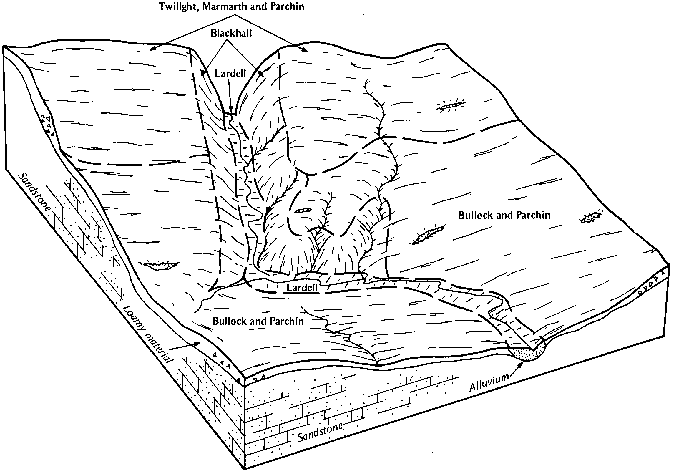
Twilight-Cabbart-Marmarth association, 4 to 15 percent slopes | 1066D | 6563 | 347569 | cnnx | mt641 | 1994 | 1:24000 |
Cabbart-Twilight-Delpoint association, 25 to 70 percent slopes | 1850F | 5365 | 347618 | cnqh | mt641 | 1994 | 1:24000 |
Bonfri-Twilight-Blacksheep fine sandy loams, wooded, 3 to 30 percent slopes | 259 | 38 | 1387752 | 1hl26 | mt643 | 1967 | 1:20000 |
Busby-Twilight-Blacksheep fine sandy loams, 8 to 35 percent slopes | 49 | 56542 | 348080 | 2wbyy | mt649 | 1985 | 1:24000 |
Twilight-Blacksheep fine sandy loams, 15 to 45 percent slopes | 178 | 15345 | 348006 | 2wbz1 | mt649 | 1985 | 1:24000 |
Busby-Twilight-Blackhall, warm, fine sandy loams, 2 to 8 percent slopes | 48 | 12915 | 348079 | cp6c | mt649 | 1985 | 1:24000 |
Twilight-Blacksheep sandy loams, 2 to 8 percent slopes | 132B | 1148 | 1712562 | 2xrsb | mt655 | 1975 | 1:24000 |
Busby-Twilight fine sandy loams, 2 to 8 percent slopes | 235C | 185 | 1712566 | 1vh22 | mt655 | 1975 | 1:24000 |
Blacksheep-Rock outcrop-Twilight complex, 8 to 45 percent slopes | 80E | 182 | 1712553 | 1vh1n | mt655 | 1975 | 1:24000 |
Blacksheep-Twilight-Busby complex, 8 to 25 percent slopes | 283E | 29 | 1712567 | 1vh23 | mt655 | 1975 | 1:24000 |
Twilight-Rentsac complex, 2 to 8 percent slopes | 381C | 5278 | 348607 | cprd | mt657 | 1990 | 1:24000 |
Twilight-Yetull-Rock outcrop complex, 8 to 25 percent slopes | 181E | 4719 | 348403 | cpjt | mt657 | 1990 | 1:24000 |
Chinook-Twilight fine sandy loams, 2 to 15 percent slopes | 534D | 2957 | 348708 | cpvn | mt657 | 1990 | 1:24000 |
Twilight-Chinook-Yetull complex, 2 to 8 percent slopes | 281C | 1666 | 348530 | cpnx | mt657 | 1990 | 1:24000 |
Twilight-Blacksheep sandy loams, 2 to 8 percent slopes | 132B | 10671 | 341640 | 2xrsb | mt666 | 2008 | 1:24000 |
Twilight-Blacksheep-Rock outcrop, complex, 4 to 25 percent slopes | 32D | 8942 | 341673 | cgjq | mt666 | 2008 | 1:24000 |
Blacksheep-Rock outcrop-Twilight complex, 8 to 45 percent slopes | 80E | 5636 | 341718 | cgl5 | mt666 | 2008 | 1:24000 |
Blacksheep-Twilight-Busby complex, 8 to 25 percent slopes | 283E | 1884 | 339995 | cdsl | mt666 | 2008 | 1:24000 |
Busby-Twilight fine sandy loams, 2 to 8 percent slopes | 235C | 1485 | 642976 | pl25 | mt666 | 2008 | 1:24000 |
Twilight sandy loam, 2 to 8 percent slopes | 32B | 1151 | 341672 | cgjp | mt666 | 2008 | 1:24000 |
Twilight-Assinniboine fine sandy loams, 3 to 9 percent slopes | TgC | 28601 | 353250 | cvl5 | sd019 | 1970 | 1:24000 |
Twilight fine sandy loam, 3 to 25 percent slopes | TfD | 24846 | 353249 | cvl4 | sd019 | 1970 | 1:24000 |
Twilight-Blackhall fine sandy loams, 6 to 18 percent slopes | ThD | 11770 | 353251 | cvl6 | sd019 | 1970 | 1:24000 |
Twilight-Parchin fine sandy loams, 6 to 15 percent slopes | TyC | 84858 | 355805 | 2wf3p | sd063 | 1984 | 1:24000 |
Twilight-Blackhall fine sandy loams, 9 to 25 percent slopes | TxE | 78958 | 355804 | 2wf3n | sd063 | 1984 | 1:24000 |
Twilight fine sandy loam, 6 to 9 percent slopes | TwC | 33855 | 355803 | 2wf3m | sd063 | 1984 | 1:24000 |
Marmarth-Twilight fine sandy loams, 6 to 9 percent slopes | MtC | 11613 | 355769 | 2zj4j | sd063 | 1984 | 1:24000 |
Marmarth-Twilight fine sandy loams, 9 to 15 percent slopes | MtD | 5007 | 355770 | 2y6dh | sd063 | 1984 | 1:24000 |
Twilight-Marmarth-Parchin fine sandy loams, 3 to 9 percent slopes | TwC | 123073 | 354666 | 2wfqm | sd105 | 1977 | 1:24000 |
Twilight-Marmarth-Parchin fine sandy loams, 3 to 9 percent slopes | TwC | 63451 | 355473 | 2wfqm | sd601 | 1983 | 1:24000 |
Blackhall-Twilight fine sandy loams, 9 to 40 percent slopes | BmE | 45297 | 355424 | cxv9 | sd601 | 1983 | 1:24000 |
Assinniboine-Twilight fine sandy loams, 6 to 9 percent slopes | AtC | 31742 | 355420 | cxv5 | sd601 | 1983 | 1:24000 |
Bonfri-Twilight-Blacksheep fine sandy loams, wooded, 3 to 30 percent slopes | 219 | 366 | 780116 | v5s1 | wy011 | 1978 | 1:24000 |
Bonfri-Twilight-Blacksheep fine sandy loams, wooded, 3 to 30 percent slopes | 259 | 1329 | 817647 | wftq | wy705 | 2003 | 1:24000 |
Toby-Twilight-Blacksheep fine sandy loams, 3 to 30 percent slopes | 322 | 583 | 817608 | wfsg | wy705 | 2003 | 1:24000 |
