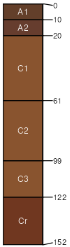
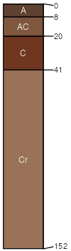
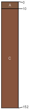
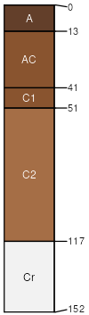
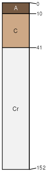
Nevee-Spearfish-Barnum, channeled, flooded complex, 2 to 40 percent slopes

Nevee (30%)
Thin Upland-North (18-22 PZ)
Aridic Ustorthents
Well drained
Hydric: No
PAWS: 22 cm
hillslopes / Backslope
Spearfish (27%)
Shallow Loamy-North (18-22 PZ)
Aridic Ustorthents
Well drained
Hydric: No
PAWS: 7 cm
hills / Summit
hills / Shoulder
Barnum (15%)
Overflow (Ov) 15-19 Precipitation Zone, Black Hills
Typic Ustifluvents
Well drained
Hydric: No
PAWS: 23 cm
flood plains / Toeslope
Gullied land (10%)
Non-site

Excessively drained
Hydric: No
PAWS: 5 cm
gulches / Backslope
gulches / Shoulder
Barnum (8%)
Loamy Terrace
Typic Ustifluvents
Well drained
Hydric: No
PAWS: 23 cm
terraces / Toeslope
Ustifluvents (4%)
Subirrigated

Moderately well drained
Hydric: Yes
PAWS: 18 cm
flood plains / Toeslope
Rekop (3%)
Shallow Loamy-West (16-20 PZ)
Aridic Ustorthents
Somewhat excessively drained
Hydric: No
PAWS: 6 cm
hills / Shoulder
hills / Summit
Gypnevee (3%)
Thin Upland-North (18-22 PZ)
Typic Ustorthents
Well drained
Hydric: No
PAWS: 16 cm
hills / Backslope
hills / Footslope
SSAScalePublishedExport
wy0451:24,00019842023-09-05