| Connerton-Barnum complex, 0 to 3 percent slopes, foothills | 201 | 2032 | 3210231 | 2zf0k | co644 | 1980 | 1:24000 |
Connerton-Barnum complex, 0 to 3 percent slopes | 24 | 1622 | 497670 | jpvw | co644 | 1980 | 1:24000 |
Barnum silt loam, moist, 0 to 2 percent slopes, rarely flooded | P028A | 1788 | 2547440 | 2qt0m | sd019 | 1970 | 1:24000 |
Barnum silt loam | Be | 469 | 353148 | cvgw | sd019 | 1970 | 1:24000 |
Barnum silt loam, channeled | Bh | 320 | 353149 | cvgx | sd019 | 1970 | 1:24000 |
Barnum silt loams, channeled, moist, 0 to 3 percent slopes, flooded | P022A | 251 | 2547438 | 2qt0l | sd019 | 1970 | 1:24000 |
Barnum silt loam, channeled, 0 to 2 percent slopes, occasionally flooded | P020A | 1773 | 2733118 | 2qt1z | sd047 | 1980 | 1:24000 |
Barnum silt loam | Bc | 1373 | 355091 | cxhk | sd047 | 1980 | 1:24000 |
Barnum, cool-Rapidcreek complex, 0 to 6 percent slopes, rarely flooded | Q0603B | 147 | 2516993 | 2mhlf | sd047 | 1980 | 1:24000 |
Barnum very fine sandy loam, cool, 0 to 3 percent slopes, rarely flooded | Q0602A | 146 | 2516992 | 2mhld | sd047 | 1980 | 1:24000 |
Barnum-Rapidcreek, warm complex, 0 to 6 percent slopes, flooded | P034B | 9 | 2768100 | 2qt22 | sd047 | 1980 | 1:24000 |
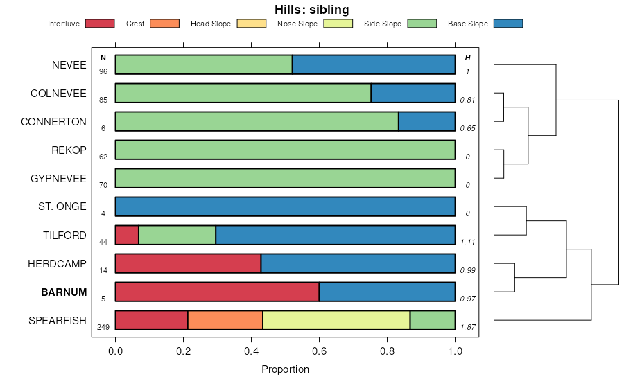
Barnum, moist, occasionally flooded-Tilford-Nevee silt loams, 1 to 25 percent slopes | P032E | 1054 | 2733290 | 2qt21 | sd081 | 2007 | 1:24000 |
Rapidcreek, warm-Nihill, moderately deep-Barnum complex, 1 to 20 percent slopes, flooded | P350D | 765 | 2733283 | 2rvgp | sd081 | 2007 | 1:24000 |
Barnum silt loam, moist, 0 to 2 percent slopes, occasionally flooded | P024A | 744 | 2733236 | 2rxt6 | sd081 | 2007 | 1:24000 |
Barnum silt loams, channeled, moist, 0 to 3 percent slopes, flooded | P022A | 695 | 2547439 | 2qt0l | sd081 | 2007 | 1:24000 |
Barnum silt loam, moist, 0 to 2 percent slopes, rarely flooded | P028A | 470 | 2547441 | 2qt0m | sd081 | 2007 | 1:24000 |
Barnum-Rapidcreek, warm complex, 0 to 6 percent slopes, flooded | P034B | 3180 | 2745643 | 2qt22 | sd607 | 2011 | 1:24000 |
Barnum, cool-Rapidcreek complex, 0 to 6 percent slopes, rarely flooded | Q0603B | 2409 | 2586550 | 2mhlf | sd607 | 2011 | 1:24000 |
Barnum very fine sandy loam, 0 to 3 percent slopes, rarely flooded | P030A | 1789 | 2745642 | 2qt20 | sd607 | 2011 | 1:24000 |
Barnum very fine sandy loam, cool, 0 to 3 percent slopes, rarely flooded | Q0602A | 537 | 2586476 | 2mhld | sd607 | 2011 | 1:24000 |
Barnum, moist-Rapidcreek, warm complex, 0 to 6 percent slopes, flooded | P035B | 338 | 2745644 | 2s039 | sd607 | 2011 | 1:24000 |
Barnum silt loam, moist, 0 to 2 percent slopes, rarely flooded | P028A | 199 | 2768133 | 2qt0m | sd607 | 2011 | 1:24000 |
Barnum-Winetti complex, 0 to 6 percent slopes | BeB | 194 | 2586452 | cyc4 | sd607 | 2011 | 1:24000 |
Barnum silt loam, channeled, 0 to 2 percent slopes, occasionally flooded | P020A | 181 | 2768131 | 2qt1z | sd607 | 2011 | 1:24000 |
Barnum silty clay loam, 0 to 3 percent slopes | 5 | 8359 | 55371 | 1vm5 | ut633 | 1983 | 1:24000 |
Barnum loam, 0 to 3 percent slopes | 3 | 5545 | 55349 | 1vlg | ut633 | 1983 | 1:24000 |
Barnum loam, 3 to 8 percent slopes | 4 | 1808 | 55360 | 1vlt | ut633 | 1983 | 1:24000 |
Barnum silt loams, moist, 0 to 3 percent slopes, flooded | P026A | 3219 | 2745711 | 2qt1p | wy011 | 1978 | 1:24000 |
Nevee-Spearfish-Barnum, channeled, flooded complex, 2 to 40 percent slopes | P260E | 1697 | 2745736 | 2rvf9 | wy011 | 1978 | 1:24000 |
Barnum silt loam, moist, 0 to 2 percent slopes, rarely flooded | P028A | 490 | 2768164 | 2qt0m | wy011 | 1978 | 1:24000 |
Barnum silt loam, moist 0 to 3 percent slopes, flooded | Q0900A | 446 | 2440139 | 2mx55 | wy011 | 1978 | 1:24000 |
Barnum silt loams, channeled, moist, 0 to 3 percent slopes, flooded | P022A | 4 | 2768163 | 2qt0l | wy011 | 1978 | 1:24000 |
Barnum silt loam, moist, 0 to 2 percent slopes, occasionally flooded | P024A | 1 | 2745946 | 2rxt6 | wy011 | 1978 | 1:24000 |
Barnum loam | 6 | 3413 | 152106 | 538n | wy043 | 1976 | 1:24000 |
Barnum silt loams, channeled, 0 to 6 percent slopes, flooded | P018B | 2406 | 2746021 | 2qt1q | wy045 | 1984 | 1:24000 |
Nevee-Spearfish-Barnum, channeled, flooded complex, 2 to 40 percent slopes | P260E | 300 | 2745981 | 2rvf9 | wy045 | 1984 | 1:24000 |
Barnum-Rapidcreek, warm complex, 0 to 6 percent slopes, flooded | P034B | 63 | 2768210 | 2qt22 | wy045 | 1984 | 1:24000 |
Barnum loam, 0 to 3 percent slopes -- Draft | a5A | 2609 | 152291 | 53gm | wy603 | | 1:24000 |
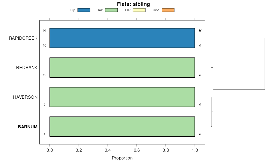
Barnum-Redbank association | BK | 3878 | 350812 | cs1j | wy619 | 1971 | 1:24000 |
Barnum silt loam | Be | 2308 | 350822 | cs1v | wy619 | 1971 | 1:24000 |
Barnum silt loam, sandy subsoil variant | Bf | 399 | 350823 | cs1w | wy619 | 1971 | 1:24000 |
Barnum-Redbank fine sandy loams, 0 to 3 percent slopes | 119 | 223 | 816592 | wdqp | wy619 | 1971 | 1:24000 |
Barnum-Redbank fine sandy loams, 0 to 3 percent slopes | 119 | 2442 | 502197 | jvkx | wy625 | 1985 | 1:24000 |


