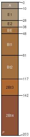
Coulstone gravelly sandy loam, 3 to 8 percent slopes
Coulstone
(90%)
Low-Base Sandstone Upland Woodland
Typic Paleudults
Somewhat excessively drained
Hydric: No
PAWS: 20 cm
interfluves / Summit
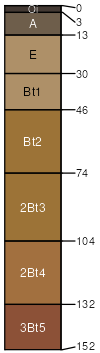
Clarksville
(4%)
Low-Base Chert Upland Woodland
Typic Paleudults
Somewhat excessively drained
Hydric: No
PAWS: 15 cm
ridges / Summit
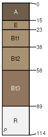
Bender
(3%)
Low-Base Sandstone Protected Backslope Woodland
Low-Base Sandstone Exposed Backslope Woodland
Typic Hapludults
Somewhat excessively drained
Hydric: No
PAWS: 2 cm
hillslopes / Backslope
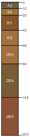
Topazmill
(3%)
Dry Footslope Forest
Typic Paleudults
Well drained
Hydric: No
PAWS: 33 cm
hillslopes / Backslope
SSA
Scale
Published
Export
mo035
1:24,000
1988
2025-09-02