| Coulstone-Bender complex, 15 to 50 percent slopes, very stony | 73223 | 23 | 2535009 | 2vxwt | mo017 | 2004 | 1:24000 |
Coulstone-Bender complex, 15 to 50 percent slopes, very stony | 73223 | 132 | 2535016 | 2vxwt | mo035 | 1988 | 1:24000 |
Coulstone-Bender complex, 15 to 35 percent slopes, extremely stony | 73273 | 23448 | 2536008 | 2qpx7 | mo055 | 2003 | 1:24000 |
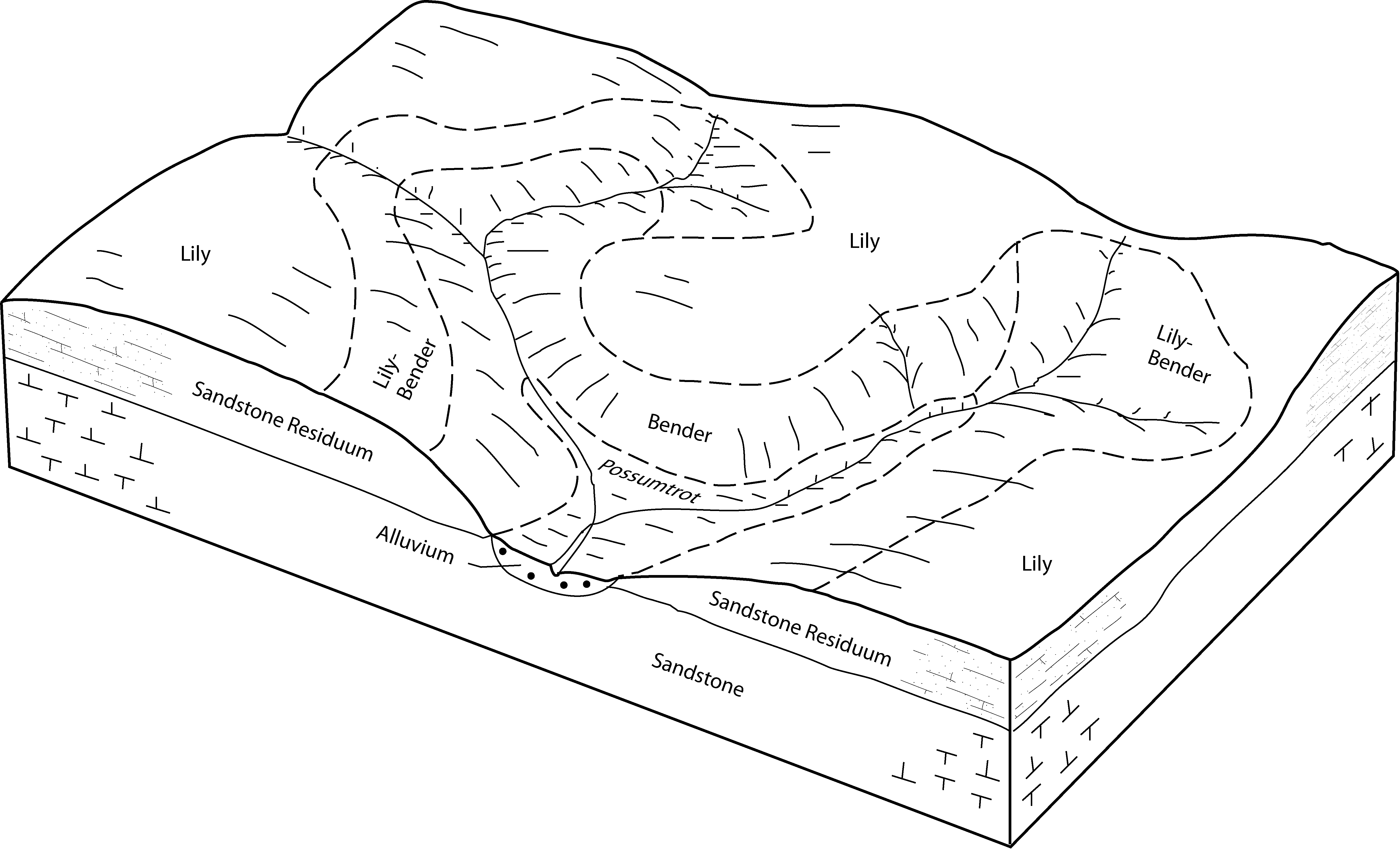
Lily-Bender complex, 3 to 15 percent slopes | 73053 | 23337 | 2534573 | 2qpg9 | mo055 | 2003 | 1:24000 |
Bender very cobbly fine sandy loam, 3 to 15 percent slopes, stony | 73066 | 13132 | 2534603 | 2qpgh | mo055 | 2003 | 1:24000 |
Bender-Rock outcrop complex, 15 to 35 percent slopes, very stony | 73067 | 8181 | 2534609 | 2qpgj | mo055 | 2003 | 1:24000 |
Bender-Rock outcrop complex, 35 to 65 percent slopes, extremely stony | 73164 | 610 | 2534884 | 2qpjb | mo055 | 2003 | 1:24000 |
Coulstone-Bender complex, 15 to 50 percent slopes, very stony | 73223 | 1747 | 2535010 | 2vxwt | mo065 | 1971 | 1:24000 |
Bender-Rock outcrop complex, 15 to 35 percent slopes, very stony | 73067 | 1413 | 2534610 | 2qpgj | mo065 | 1971 | 1:24000 |
Lily-Bender complex, 3 to 15 percent slopes | 73053 | 849 | 2534574 | 2qpg9 | mo065 | 1971 | 1:24000 |
Bender very cobbly fine sandy loam, 3 to 15 percent slopes, stony | 73066 | 122 | 2534604 | 2qpgh | mo065 | 1971 | 1:24000 |
Bender-Alred-Rock outcrop complex, 15 to 60 percent slopes, very stony | 73081 | 65 | 2534665 | 2qpgw | mo065 | 1971 | 1:24000 |
Bender-Rock outcrop complex, 35 to 65 percent slopes, extremely stony | 73164 | 41 | 2534885 | 2qpjb | mo065 | 1971 | 1:24000 |
Coulstone-Bender complex, 15 to 50 percent slopes, very stony | 73223 | 75573 | 2535007 | 2vxwt | mo067 | 2004 | 1:24000 |
Coulstone-Bender-Gatewood complex, 15 to 60 percent slopes, rocky, very stony | 73230 | 1740 | 2535902 | 2qpkd | mo067 | 2004 | 1:24000 |
Coulstone-Bender complex, 15 to 35 percent slopes, extremely stony | 73273 | 118 | 2536009 | 2qpx7 | mo071 | 1986 | 1:24000 |
Lily-Bender complex, 3 to 15 percent slopes | 73053 | 11 | 2534575 | 2qpg9 | mo071 | 1986 | 1:24000 |
Coulstone-Bender complex, 15 to 35 percent slopes, extremely stony | 73273 | 508 | 2536010 | 2qpx7 | mo073 | 1992 | 1:24000 |
Bender very cobbly fine sandy loam, 3 to 15 percent slopes, stony | 73066 | 41 | 2534605 | 2qpgh | mo073 | 1992 | 1:24000 |
Bender-Rock outcrop complex, 35 to 65 percent slopes, extremely stony | 73164 | 27 | 2534886 | 2qpjb | mo073 | 1992 | 1:24000 |
Coulstone-Bender complex, 15 to 50 percent slopes, very stony | 73223 | 14255 | 2535011 | 2vxwt | mo091 | 2004 | 1:24000 |
Coulstone-Bender-Gatewood complex, 15 to 60 percent slopes, rocky, very stony | 73230 | 6455 | 2535903 | 2qpkd | mo091 | 2004 | 1:24000 |
Coulstone-Bender complex, 15 to 35 percent slopes, extremely stony | 73273 | 3 | 2536011 | 2qpx7 | mo093 | 1988 | 1:24000 |
Coulstone-Bender-Gatewood complex, 15 to 60 percent slopes, rocky, very stony | 73230 | 6829 | 2535901 | 2qpkd | mo149 | 2004 | 1:24000 |
Coulstone-Bender complex, 15 to 50 percent slopes, very stony | 73223 | 1162 | 2535017 | 2vxwt | mo149 | 2004 | 1:24000 |
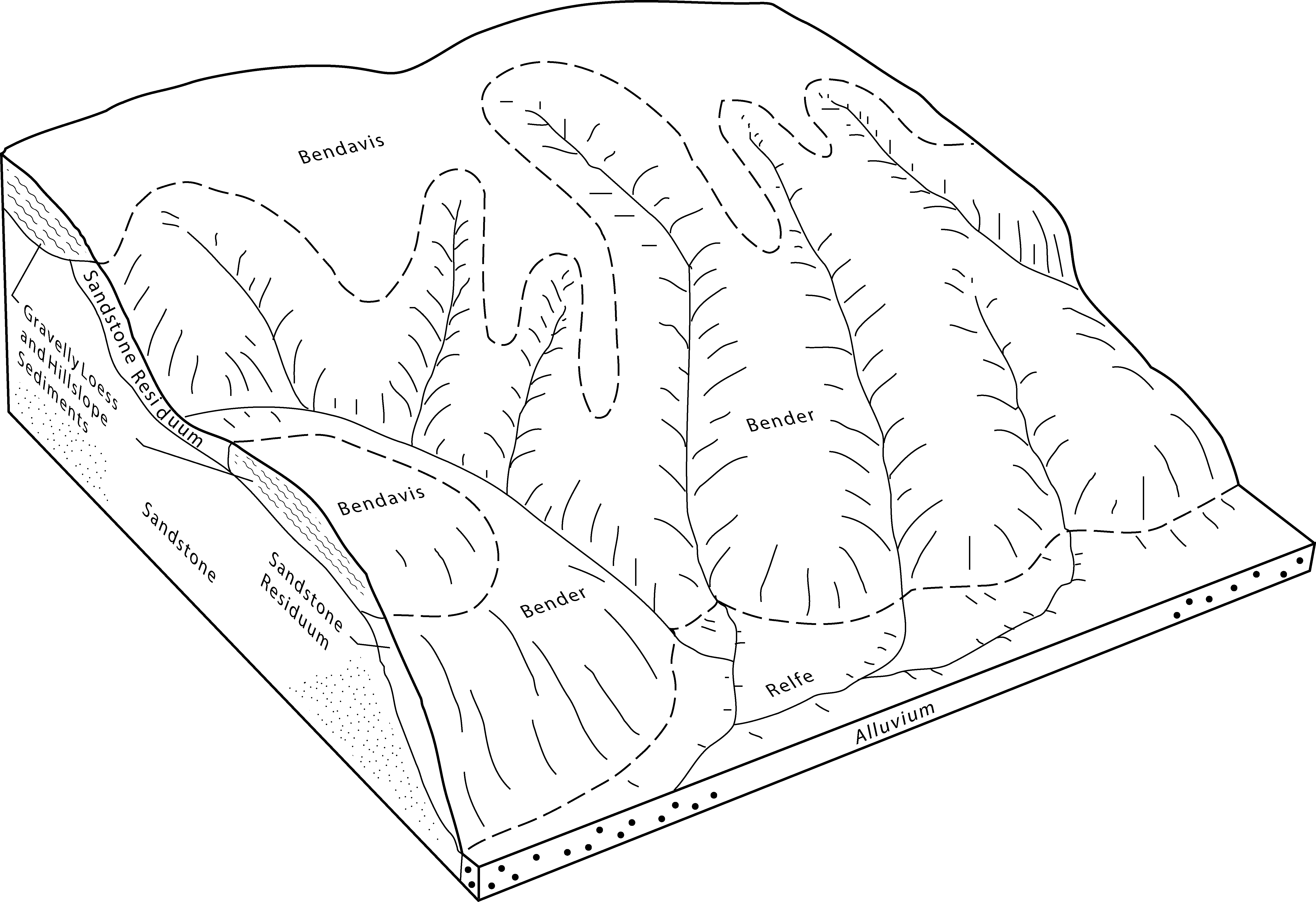
Bender-Moko-Rock outcrop complex, 35 to 60 percent slopes, very stony | 73318 | 703 | 1154337 | 17r5p | mo149 | 2004 | 1:24000 |
Coulstone-Bender complex, 15 to 50 percent slopes, very stony | 73223 | 26337 | 2535012 | 2vxwt | mo153 | 2003 | 1:24000 |
Coulstone-Bender-Gatewood complex, 15 to 60 percent slopes, rocky, very stony | 73230 | 1556 | 2535904 | 2qpkd | mo153 | 2003 | 1:24000 |
Bender-Rock outcrop complex, 15 to 35 percent slopes, very stony | 73067 | 68655 | 2534611 | 2qpgj | mo161 | 2001 | 1:24000 |
Lily-Bender complex, 3 to 15 percent slopes | 73053 | 24458 | 2534576 | 2qpg9 | mo161 | 2001 | 1:24000 |
Bender-Rock outcrop complex, 35 to 65 percent slopes, extremely stony | 73164 | 5049 | 2534887 | 2qpjb | mo161 | 2001 | 1:24000 |
Bender very cobbly fine sandy loam, 3 to 15 percent slopes, stony | 73066 | 2735 | 2534606 | 2qpgh | mo161 | 2001 | 1:24000 |
Bender-Rock outcrop complex, karst, 15 to 35 percent slopes, very stony | 73187 | 237 | 574605 | m8xn | mo161 | 2001 | 1:24000 |
Bender-Rock outcrop complex, 15 to 35 percent slopes, very stony | 73067 | 706 | 2534612 | 2qpgj | mo169 | 1984 | 1:24000 |
Lily-Bender complex, 3 to 15 percent slopes | 73053 | 51 | 2534577 | 2qpg9 | mo169 | 1984 | 1:24000 |
Bender-Rock outcrop complex, 35 to 65 percent slopes, extremely stony | 73164 | 15 | 2534883 | 2qpjb | mo169 | 1984 | 1:24000 |
Coulstone-Bender complex, 15 to 50 percent slopes, very stony | 73223 | 27696 | 2535013 | 2vxwt | mo179 | 2004 | 1:24000 |
Coulstone-Bender complex, 15 to 50 percent slopes, very stony | 73223 | 53512 | 2535006 | 2vxwt | mo203 | 2004 | 1:24000 |
Lily-Bender complex, 3 to 15 percent slopes | 73053 | 1525 | 2534572 | 2qpg9 | mo203 | 2004 | 1:24000 |
Bender-Alred-Rock outcrop complex, 15 to 60 percent slopes, very stony | 73081 | 105 | 2534664 | 2qpgw | mo203 | 2004 | 1:24000 |
Bender-Rock outcrop complex, 15 to 35 percent slopes, very stony | 73067 | 50357 | 2534613 | 2qpgj | mo215 | 2002 | 1:24000 |
Lily-Bender complex, 3 to 15 percent slopes | 73053 | 16023 | 2534578 | 2qpg9 | mo215 | 2002 | 1:24000 |
Bender-Alred-Rock outcrop complex, 15 to 60 percent slopes, very stony | 73081 | 15229 | 2534666 | 2qpgw | mo215 | 2002 | 1:24000 |
Bender very cobbly fine sandy loam, 3 to 15 percent slopes, stony | 73066 | 13091 | 2534607 | 2qpgh | mo215 | 2002 | 1:24000 |
Coulstone-Bender complex, 15 to 50 percent slopes, very stony | 73223 | 965 | 2535014 | 2vxwt | mo215 | 2002 | 1:24000 |
Coulstone-Bender complex, 15 to 35 percent slopes, extremely stony | 73273 | 15879 | 2536007 | 2qpx7 | mo221 | 2003 | 1:24000 |
Bender very cobbly fine sandy loam, 3 to 15 percent slopes, stony | 73066 | 2248 | 2534601 | 2qpgh | mo221 | 2003 | 1:24000 |
Bender-Rock outcrop complex, 15 to 35 percent slopes, very stony | 73067 | 513 | 2534608 | 2qpgj | mo221 | 2003 | 1:24000 |
Lily-Bender complex, 3 to 15 percent slopes | 73053 | 411 | 2534579 | 2qpg9 | mo221 | 2003 | 1:24000 |
Coulstone-Bender complex, 15 to 50 percent slopes, very stony | 73223 | 195 | 2535015 | 2vxwt | mo223 | 2004 | 1:24000 |
Coulstone-Bender complex, 15 to 50 percent slopes, very stony | 73223 | 2263 | 2535008 | 2vxwt | mo229 | 1979 | 1:24000 |


