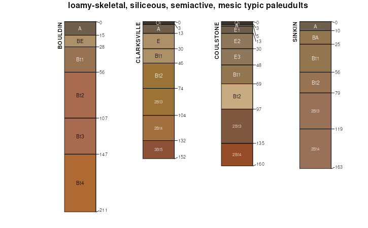
| Coulstone-Bender complex, 15 to 50 percent slopes, very stony | 73223 | 23 | 2535009 | 2vxwt | mo017 | 2004 | 1:24000 |
Coulstone very gravelly sandy loam, 15 to 35 percent slopes, stony | 73402 | 12510 | 2502511 | 2vxss | mo035 | 1988 | 1:24000 |
Coulstone gravelly sandy loam, 3 to 8 percent slopes | 73403 | 4196 | 2502515 | 2vxst | mo035 | 1988 | 1:24000 |
Coulstone very gravelly sandy loam, 8 to 15 percent slopes | 73405 | 3416 | 2502523 | 2vxsw | mo035 | 1988 | 1:24000 |
Coulstone very gravelly sandy loam, 35 to 60 percent slopes, very stony | 73404 | 1180 | 2502519 | 2vxsv | mo035 | 1988 | 1:24000 |
Coulstone-Clarksville-Rock outcrop complex, 35 to 60 percent slopes | 73411 | 262 | 2502533 | 2vxsz | mo035 | 1988 | 1:24000 |
Coulstone-Clarksville-Rock outcrop complex, 15 to 35 percent slopes | 73410 | 252 | 2502529 | 2vxsy | mo035 | 1988 | 1:24000 |
Coulstone-Bender complex, 15 to 50 percent slopes, very stony | 73223 | 132 | 2535016 | 2vxwt | mo035 | 1988 | 1:24000 |
Coulstone-Clarksville-Rock outcrop complex, 8 to 15 percent slopes | 73412 | 89 | 2502537 | 2q24g | mo035 | 1988 | 1:24000 |
Coulstone-Alred complex, 15 to 50 percent slopes, very stony | 73361 | 19 | 2502470 | 2vxsg | mo035 | 1988 | 1:24000 |
Coulstone-Clarksville complex, 35 to 50 percent slopes, very stony | 73408 | 4 | 2502528 | 2q24c | mo035 | 1988 | 1:24000 |
Coulstone-Bender complex, 15 to 35 percent slopes, extremely stony | 73273 | 23448 | 2536008 | 2qpx7 | mo055 | 2003 | 1:24000 |
Coulstone-Clarksville complex, 15 to 35 percent slopes, very stony | 73406 | 36328 | 1008329 | 2t7g4 | mo065 | 1971 | 1:24000 |
Coulstone-Clarksville complex, 35 to 50 percent slopes, very stony | 73408 | 21719 | 2502527 | 2q24c | mo065 | 1971 | 1:24000 |
Coulstone-Clarksville complex, 3 to 8 percent slopes | 73407 | 18460 | 1008327 | 2t7g2 | mo065 | 1971 | 1:24000 |
Coulstone-Clarksville complex, 8 to 15 percent slopes | 73409 | 8986 | 1008328 | 2t7g3 | mo065 | 1971 | 1:24000 |
Coulstone-Bender complex, 15 to 50 percent slopes, very stony | 73223 | 1747 | 2535010 | 2vxwt | mo065 | 1971 | 1:24000 |
Coulstone-Alred complex, 15 to 50 percent slopes, very stony | 73361 | 888 | 2502469 | 2vxsg | mo065 | 1971 | 1:24000 |
Coulstone-Bender complex, 15 to 50 percent slopes, very stony | 73223 | 75573 | 2535007 | 2vxwt | mo067 | 2004 | 1:24000 |
Topazmill-Coulstone complex, 3 to 15 percent slopes | 73326 | 2086 | 692389 | r7h4 | mo067 | 2004 | 1:24000 |
Coulstone-Bender-Gatewood complex, 15 to 60 percent slopes, rocky, very stony | 73230 | 1740 | 2535902 | 2qpkd | mo067 | 2004 | 1:24000 |
Topazmill-Coulstone complex, 15 to 35 percent slopes | 73327 | 193 | 692390 | r7h5 | mo067 | 2004 | 1:24000 |
Coulstone-Bender complex, 15 to 35 percent slopes, extremely stony | 73273 | 118 | 2536009 | 2qpx7 | mo071 | 1986 | 1:24000 |
Coulstone very gravelly sandy loam, 15 to 35 percent slopes, stony | 73402 | 7 | 2502509 | 2vxss | mo071 | 1986 | 1:24000 |
Coulstone very gravelly sandy loam, 15 to 35 percent slopes, stony | 73402 | 10887 | 2502510 | 2vxss | mo073 | 1992 | 1:24000 |
Coulstone-Bender complex, 15 to 35 percent slopes, extremely stony | 73273 | 508 | 2536010 | 2qpx7 | mo073 | 1992 | 1:24000 |
Coulstone-Bender complex, 15 to 50 percent slopes, very stony | 73223 | 14255 | 2535011 | 2vxwt | mo091 | 2004 | 1:24000 |
Coulstone-Bender-Gatewood complex, 15 to 60 percent slopes, rocky, very stony | 73230 | 6455 | 2535903 | 2qpkd | mo091 | 2004 | 1:24000 |
Coulstone-Bender complex, 15 to 35 percent slopes, extremely stony | 73273 | 3 | 2536011 | 2qpx7 | mo093 | 1988 | 1:24000 |
Coulstone very gravelly sandy loam, 15 to 35 percent slopes, stony | 73402 | 10389 | 2502512 | 2vxss | mo149 | 2004 | 1:24000 |
Coulstone-Bender-Gatewood complex, 15 to 60 percent slopes, rocky, very stony | 73230 | 6829 | 2535901 | 2qpkd | mo149 | 2004 | 1:24000 |
Coulstone very gravelly sandy loam, 35 to 60 percent slopes, very stony | 73404 | 3348 | 2502520 | 2vxsv | mo149 | 2004 | 1:24000 |
Coulstone gravelly sandy loam, 3 to 8 percent slopes | 73403 | 3135 | 2502516 | 2vxst | mo149 | 2004 | 1:24000 |
Coulstone very gravelly sandy loam, 8 to 15 percent slopes | 73405 | 1444 | 2502524 | 2vxsw | mo149 | 2004 | 1:24000 |
Coulstone-Bender complex, 15 to 50 percent slopes, very stony | 73223 | 1162 | 2535017 | 2vxwt | mo149 | 2004 | 1:24000 |
Coulstone-Clarksville-Rock outcrop complex, 35 to 60 percent slopes | 73411 | 1042 | 2502534 | 2vxsz | mo149 | 2004 | 1:24000 |
Coulstone-Clarksville-Rock outcrop complex, 15 to 35 percent slopes | 73410 | 445 | 2502530 | 2vxsy | mo149 | 2004 | 1:24000 |
Coulstone-Clarksville-Rock outcrop complex, 8 to 15 percent slopes | 73412 | 9 | 2502538 | 2q24g | mo149 | 2004 | 1:24000 |
Coulstone-Bender complex, 15 to 50 percent slopes, very stony | 73223 | 26337 | 2535012 | 2vxwt | mo153 | 2003 | 1:24000 |
Coulstone-Bender-Gatewood complex, 15 to 60 percent slopes, rocky, very stony | 73230 | 1556 | 2535904 | 2qpkd | mo153 | 2003 | 1:24000 |
Coulstone-Bender complex, 15 to 50 percent slopes, very stony | 73223 | 27696 | 2535013 | 2vxwt | mo179 | 2004 | 1:24000 |
Coulstone very gravelly sandy loam, 15 to 35 percent slopes, stony | 73402 | 8324 | 2502513 | 2vxss | mo181 | 1982 | 1:24000 |
Coulstone very gravelly sandy loam, 35 to 60 percent slopes, very stony | 73404 | 2458 | 2502521 | 2vxsv | mo181 | 1982 | 1:24000 |
Coulstone gravelly sandy loam, 3 to 8 percent slopes | 73403 | 2036 | 2502517 | 2vxst | mo181 | 1982 | 1:24000 |
Coulstone very gravelly sandy loam, 8 to 15 percent slopes | 73405 | 1658 | 2502525 | 2vxsw | mo181 | 1982 | 1:24000 |
Coulstone-Clarksville-Rock outcrop complex, 15 to 35 percent slopes | 73410 | 150 | 2502531 | 2vxsy | mo181 | 1982 | 1:24000 |
Coulstone-Clarksville-Rock outcrop complex, 35 to 60 percent slopes | 73411 | 135 | 2502535 | 2vxsz | mo181 | 1982 | 1:24000 |
Coulstone-Alred complex, 15 to 50 percent slopes, very stony | 73361 | 58739 | 2502471 | 2vxsg | mo203 | 2004 | 1:24000 |
Coulstone-Bender complex, 15 to 50 percent slopes, very stony | 73223 | 53512 | 2535006 | 2vxwt | mo203 | 2004 | 1:24000 |
Coulstone very gravelly sandy loam, 15 to 35 percent slopes, stony | 73402 | 8568 | 2502514 | 2vxss | mo203 | 2004 | 1:24000 |
Coulstone very gravelly sandy loam, 8 to 15 percent slopes | 73405 | 3411 | 2502526 | 2vxsw | mo203 | 2004 | 1:24000 |
Coulstone gravelly sandy loam, 3 to 8 percent slopes | 73403 | 1916 | 2502518 | 2vxst | mo203 | 2004 | 1:24000 |
Coulstone very gravelly sandy loam, 35 to 60 percent slopes, very stony | 73404 | 234 | 2502522 | 2vxsv | mo203 | 2004 | 1:24000 |
Coulstone-Clarksville-Rock outcrop complex, 8 to 15 percent slopes | 73412 | 63 | 2502539 | 2q24g | mo203 | 2004 | 1:24000 |
Coulstone-Clarksville-Rock outcrop complex, 15 to 35 percent slopes | 73410 | 22 | 2502532 | 2vxsy | mo203 | 2004 | 1:24000 |
Coulstone-Clarksville-Rock outcrop complex, 35 to 60 percent slopes | 73411 | 10 | 2502536 | 2vxsz | mo203 | 2004 | 1:24000 |
Coulstone-Bender complex, 15 to 50 percent slopes, very stony | 73223 | 965 | 2535014 | 2vxwt | mo215 | 2002 | 1:24000 |
Coulstone-Bender complex, 15 to 35 percent slopes, extremely stony | 73273 | 15879 | 2536007 | 2qpx7 | mo221 | 2003 | 1:24000 |
Coulstone-Bender complex, 15 to 50 percent slopes, very stony | 73223 | 195 | 2535015 | 2vxwt | mo223 | 2004 | 1:24000 |
Coulstone-Bender complex, 15 to 50 percent slopes, very stony | 73223 | 2263 | 2535008 | 2vxwt | mo229 | 1979 | 1:24000 |
Coulstone gravelly loam, 8 to 15 percent slopes | 73540 | 1631 | 1018069 | 135cy | mo229 | 1979 | 1:24000 |
Coulstone gravelly loam, 3 to 8 percent slopes | 73539 | 1399 | 1018067 | 135cw | mo229 | 1979 | 1:24000 |
