Almy-Monbutte-Rallod complex, 1 to 10 percent slopes
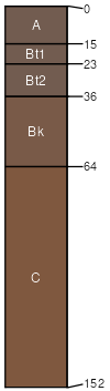
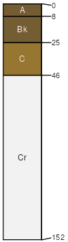
Almy
(40%)
Loamy High Plains Southeast (Ly)
Ustic Haplargids
Well drained
Hydric: No
PAWS: 26 cm
basin floors
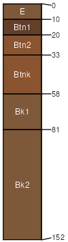
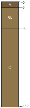
Monbutte
(25%)
Clayey High Plains Southeast (Cy)
Ustic Natrargids
Well drained
Hydric: No
PAWS: 21 cm
basin-floor remnants
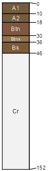
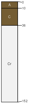
Rallod
(15%)
Shallow Loamy High Plains Southeast (SwLy)
Ustic Natrargids
Well drained
Hydric: No
PAWS: 5 cm
basin floors
Slick spots
(4%)
Hydric: No
PAWS: NA
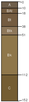
Forelle
(4%)
Loamy High Plains Southeast (Ly)
Ustic Haplargids
Well drained
Hydric: No
PAWS: 22 cm
fan aprons
Blazon
(4%)
Shallow Clayey High Plains Southeast (SwCy)
Ustic Torriorthents
Well drained
Hydric: No
PAWS: 9 cm
hillslopes
plateaus
ridges
pediments
Poposhia
(4%)
Clayey High Plains Southeast (Cy)
Ustic Haplocambids
Well drained
Hydric: No
PAWS: 23 cm
fan aprons
Seaverson
(4%)
Saline Upland High Plains Southeast (SU)
Ustic Torriorthents
Well drained
Hydric: No
PAWS: 3 cm
hills
SSA
Scale
Published
Export
wy677
1:24,000
1975
2025-09-04