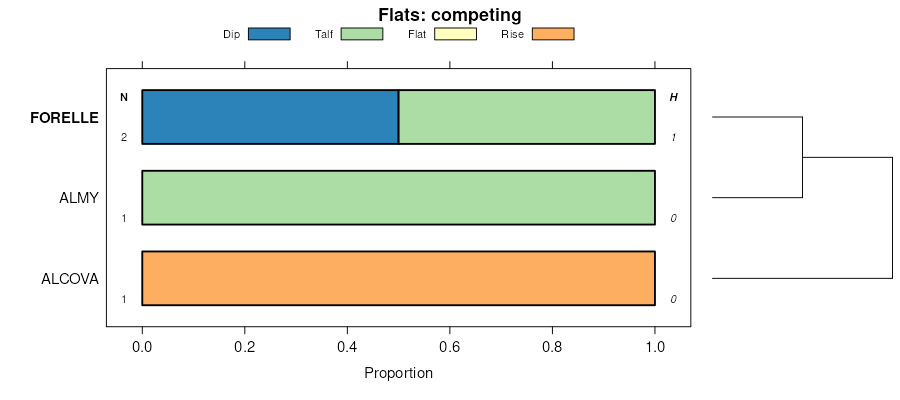
| Forelle loam | Fo | 11234 | 497782 | jpzh | co646 | 1973 | 1:24000 |
Forelle loam, 3 to 15 percent slopes | 29 | 935 | 497852 | jq1r | co649 | 1977 | 1:24000 |
Forelle loam, 15 to 30 percent slopes | 30 | 778 | 497854 | jq1t | co649 | 1977 | 1:24000 |
Forelle-Brownsto complex, 12 to 25 percent slopes | 44 | 11147 | 497985 | jq61 | co655 | 1984 | 1:24000 |
Forelle-Brownsto complex, 6 to 12 percent slopes | 43 | 4486 | 497984 | jq60 | co655 | 1984 | 1:24000 |
Forelle-Cushool complex, moist, 6 to 25 percent slopes | 63 | 3495 | 506755 | k09y | co680 | 1970 | 1:31680 |
Forelle-Cushool complex, moist, 6 to 25 percent slopes | MC63 | 1630 | 3170515 | k09y | co682 | 1986 | 1:24000 |
Forelle loam, 3 to 8 percent slopes | 33 | 16711 | 496983 | jp4q | co685 | 1979 | 1:24000 |
Forelle loam, 8 to 15 percent slopes | 34 | 5734 | 496984 | jp4r | co685 | 1979 | 1:24000 |
Forelle loam, 3 to 12 percent slopes | 77 | 60537 | 497256 | jpfj | co686 | 1992 | 1:31680 |
Forelle-Evanot complex, 1 to 12 percent slopes | 79 | 21575 | 497258 | jpfl | co686 | 1992 | 1:31680 |
Forelle-Pinelli-Maysprings complex, 5 to 20 percent slopes | 82 | 14110 | 497262 | jpfq | co686 | 1992 | 1:31680 |
Forelle-Evanot complex, 12 to 25 percent slopes | 80 | 9058 | 497260 | jpfn | co686 | 1992 | 1:31680 |
Forelle loam, 12 to 25 percent slopes | 78 | 8811 | 497257 | jpfk | co686 | 1992 | 1:31680 |
Forelle-Obadia complex, 1 to 8 percent slopes | 81 | 4865 | 497261 | jpfp | co686 | 1992 | 1:31680 |
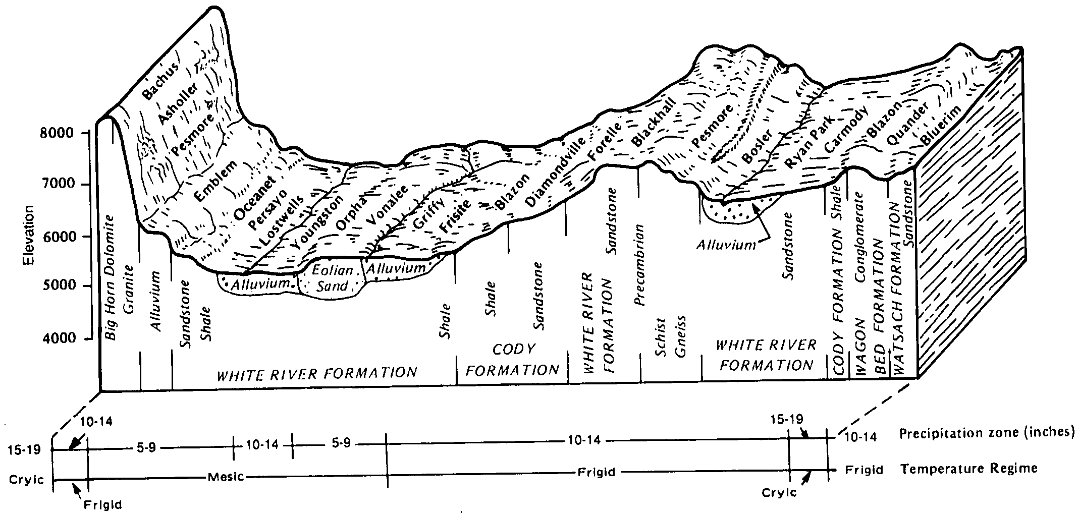
Forelle-Diamondville association, 3 to 15 percent slopes | 158 | 1382 | 104513 | 3hrd | wy031 | 1998 | 1:24000 |
Poposhia-Forelle complex, 1 to 8 percent slopes | 204 | 369 | 104559 | 3hsw | wy031 | 1998 | 1:24000 |
Forelle loam, 0 to 6 percent slopes | 157 | 49 | 104512 | 3hrc | wy031 | 1998 | 1:24000 |
Forelle-Diamondville association, 3 to 15 percent slopes | 165 | 67573 | 501706 | jv22 | wy601 | 1991 | 1:24000 |
Poposhia-Forelle complex, 1 to 8 percent slopes | 198 | 63638 | 501742 | jv37 | wy601 | 1991 | 1:24000 |
Forelle loam, 0 to 6 percent slopes | 163 | 51739 | 501704 | jv20 | wy601 | 1991 | 1:24000 |
Forelle-Urban land complex, 0 to 3 percent slopes | 164 | 108 | 501705 | jv21 | wy601 | 1991 | 1:24000 |
Forelle loam, 0 to 6 percent slopes | 148 | 345 | 1669685 | 1t1ft | wy609 | 2006 | 1:24000 |
Forelle-Diamondville complex, 3 to 15 percent slopes | 149 | 231 | 1669798 | 1t1kg | wy609 | 2006 | 1:24000 |
Forelle-Diamondville complex, 3 to 15 percent slopes | 184 | 27732 | 502272 | jvnb | wy625 | 1985 | 1:24000 |
Forelle loam, 2 to 9 percent slopes | 183 | 14930 | 502271 | jvn9 | wy625 | 1985 | 1:24000 |
Forelle-Lupinto association, rolling | 185 | 1303 | 502273 | jvnc | wy625 | 1985 | 1:24000 |
Forelle-Obadia-like complex, 0 to 3 percent slopes -- Draft | 2103 | 17914 | 2552270 | 2qtzs | wy629 | | 1:24000 |
Forelle-Fluetsch complex, 4 to 15 percent slopes, stony -- Draft | 5402 | 894 | 2498433 | 2qd6b | wy629 | | 1:24000 |
Tisworth-Forelle complex, 0 to 10 percent slopes -- Draft | 240 | 141 | 152488 | 53nz | wy629 | | 1:24000 |
Forelle-Diamondville loams, 3 to 15 percent slopes -- draft | 310 | 25103 | 2378241 | 2ktrg | wy630 | | 1:24000 |
Pinelli-Forelle association, 3 to 15 percent slopes -- draft | 404 | 13471 | 2437986 | 2mtxq | wy630 | | 1:24000 |
Absher-Forelle complex, 3 to 15 percent slopes -- draft | 395 | 10368 | 2437983 | 2mtxm | wy630 | | 1:24000 |
Forelle loam, 0 to 6 percent slopes -- draft | 309 | 9545 | 2378243 | 2ktrj | wy630 | | 1:24000 |
Forelle loams, 6 to 15 percent slopes -- draft | 309CD | 1147 | 2404373 | 2lpyf | wy630 | | 1:24000 |
Diamondville-Oasiswell-Forelle complex, 1 to 10 percent slopes | 5430 | 19662 | 2426357 | 2mftl | wy635 | | 1:24000 |
Bluerim-Ravenhole-Forelle complex, 1 to 8 percent slopes | 9405 | 8071 | 2771658 | 2t6cv | wy635 | | 1:24000 |
Sandbranch taxadjunct-Obadia-Forelle complex, 0 to 4 percent slopes | 9202 | 7508 | 2843441 | 2tsc0 | wy635 | | 1:24000 |
Forelle-Bluerim-Worfman complex, 2 to 35 percent slopes | 5504 | 6352 | 1475575 | 1ljg6 | wy635 | | 1:24000 |
Yodlow-Forelle-Worfman complex, 1 to 10 percent slopes | 9409 | 5348 | 2771659 | 2t6cw | wy635 | | 1:24000 |
Forelle-Blazon, rubbly surface-Cushool complex, 4 to 35 percent slopes | 5604 | 3800 | 1475588 | 1ljgm | wy635 | | 1:24000 |
Forelle-Bluerim-Cotha complex, 1 to 6 percent slopes | 2308 | 3010 | 1486742 | 1lx2f | wy635 | | 1:24000 |
Farson-Forelle complex, 0 to 4 percent slopes | 9213 | 1701 | 2771654 | 2t6cq | wy635 | | 1:24000 |
Forelle-Pinelli complex, 2 to 15 percent slopes | 5336 | 1598 | 2514546 | 2qcsl | wy635 | | 1:24000 |
Diamondville-Forelle sandy loams, 0 to 3 percent slopes | 55 | 928 | 502917 | jwb4 | wy636 | 1986 | 1:15840 |
Forelle-Diamondville sandy loams, 3 to 6 percent slopes | 69 | 289 | 502931 | jwbl | wy636 | 1986 | 1:15840 |
Forelle sandy loam, 0 to 1 percent slopes | 68 | 225 | 502930 | jwbk | wy636 | 1986 | 1:15840 |
Bluerim-Ravenhole-Forelle complex, 1 to 8 percent slopes | 9405 | 198 | 2892465 | 2t6cv | wy636 | 1986 | 1:15840 |
Sandbranch taxadjunct-Obadia-Forelle complex, 0 to 4 percent slopes | 9202 | 66 | 2892468 | 2tsc0 | wy636 | 1986 | 1:15840 |
Farson-Forelle complex, 0 to 4 percent slopes | 9213 | 15 | 2892464 | 2t6cq | wy636 | 1986 | 1:15840 |
Forelle-Bluerim-Worfman complex, 2 to 35 percent slopes | 5504 | 11 | 2892460 | 1ljg6 | wy636 | 1986 | 1:15840 |
Forelle-Diamondville loams, 2 to 25 percent slopes | 028 | 21253 | 157537 | 58xv | wy647 | | 1:24000 |
Forelle-Milren loams, 1 to 6 percent slopes | 029 | 15536 | 157536 | 58xt | wy647 | | 1:24000 |
Forelle-Poposhia loams, 2 to 12 percent slopes | 294 | 12116 | 157478 | 58vy | wy647 | | 1:24000 |
Luhon-Rock River-Forelle complex, 1 to 10 percent slopes | 037 | 9522 | 157550 | 58y8 | wy647 | | 1:24000 |
Havre-Absher-Forelle loams, 0 to 6 percent slopes | 033 | 8335 | 157532 | 58xp | wy647 | | 1:24000 |
Havre-Forelle-Cowestglen complex, 0 to 3 percent slopes | 422 | 372 | 1859090 | 20djn | wy647 | | 1:24000 |
Forelle-Luhon complex, 1 to 10 percent slopes | 147D | 24 | 157952 | 59c7 | wy656 | 2008 | 1:24000 |
Patent-Forelle association | 39 | 45400 | 159093 | 5bk1 | wy677 | 1975 | 1:24000 |
Diamondville-Forelle association | 10 | 11268 | 159051 | 5bhp | wy677 | 1975 | 1:24000 |
Forelle-Poposhia association, 2 to 12 percent slopes | 53 | 2182 | 1901555 | 21tqh | wy677 | 1975 | 1:24000 |
Forelle sandy clay loam, 0 to 6 percent slopes | 19 | 1483 | 159071 | 5bjb | wy677 | 1975 | 1:24000 |
Havre-Absher-Forelle loams, 0 to 6 percent slopes | 54 | 1387 | 1901556 | 21tqj | wy677 | 1975 | 1:24000 |
Havre-Forelle-Glendive complex, 0 to 3 percent slopes | 52 | 1229 | 1901557 | 21tqk | wy677 | 1975 | 1:24000 |
Forelle sandy clay loam, 6 to 10 percent slopes | 20 | 1051 | 159066 | 5bj5 | wy677 | 1975 | 1:24000 |
Diamondville-Forelle association, rolling | 58 | 506 | 1901554 | 21tqg | wy677 | 1975 | 1:24000 |
Luhon-Rock River-Forelle complex, undulating | 65 | 169 | 1901566 | 21tqv | wy677 | 1975 | 1:24000 |
Havre-Absher-Forelle loams, 0 to 6 percent slopes | 157 | 57390 | 503022 | jwfj | wy713 | 1986 | 1:24000 |
Havre-Forelle-Glendive complex, 0 to 3 percent slopes | 158 | 47839 | 503023 | jwfk | wy713 | 1986 | 1:24000 |
Forelle-Poposhia association, 2 to 12 percent slopes | 148 | 47793 | 503013 | jwf7 | wy713 | 1986 | 1:24000 |
Diamondville-Forelle association, rolling | 142 | 46780 | 503007 | jwf1 | wy713 | 1986 | 1:24000 |
Luhon-Rock River-Forelle complex, undulating | 169 | 18580 | 503034 | jwfx | wy713 | 1986 | 1:24000 |
Tisworth-Absher-Forelle complex, 0 to 6 percent slopes | 212 | 5353 | 503088 | jwhn | wy713 | 1986 | 1:24000 |
Forelle-Luhon loams, 1 to 10 percent slopes | 147 | 4936 | 503012 | jwf6 | wy713 | 1986 | 1:24000 |
Forelle, moderately deep-Rock River-Poposhia complex, 0 to 6 percent slopes -- draft | 7141 | 23936 | 2518744 | 2q048 | wy723 | | 1:24000 |
Farson-Forelle complex, 0 to 4 percent slopes | 9213 | 2174 | 2970252 | 2t6cq | wy723 | | 1:24000 |
Sandbranch taxadjunct-Obadia-Forelle complex, 0 to 4 percent slopes | 9202 | 1935 | 2970262 | 2tsc0 | wy723 | | 1:24000 |
Diamondville-Oasiswell-Forelle complex, 1 to 10 percent slopes | 5430 | 806 | 2554669 | 2mftl | wy723 | | 1:24000 |
Yodlow-Forelle-Worfman complex, 1 to 10 percent slopes | 9409 | 307 | 2970255 | 2t6cw | wy723 | | 1:24000 |
Poposhia-Forelle-Scooby complex, 0 to 6 percent slopes | 4424 | 28769 | 3406459 | 3133l | wy737 | | 1:24000 |
Grotte family-Leptic Haplogypsids-Forelle complex, 4 to 15 percent slopes | 2462 | 22207 | 2572316 | 2mqjj | wy737 | | 1:24000 |
Redcreek-Forelle family-Grieves family, complex, 2 to 20 percent slopes | 4427 | 21887 | 3406462 | 3133p | wy737 | | 1:24000 |
Starwash-Starwash, sandy surface-Forelle complex, 1 to 8 percent slopes | 4303 | 17719 | 3222314 | 2zjtb | wy737 | | 1:24000 |
Forelle family-Piceance family-Blazon, very stony, complex, 4 to 25 percent slopes | 4323 | 15659 | 3406572 | 31fxr | wy737 | | 1:24000 |
Anchutz-Forelle-Forelle, sandy surface, complex, 1 to 8 percent slopes | 4308 | 15339 | 3222339 | 2zjth | wy737 | | 1:24000 |
Sweetlette-Forelle-Yellowwash complex, 4 to 15 percent slopes | 4128 | 11699 | 3406431 | 31d7x | wy737 | | 1:24000 |
Forelle-Scooby complex, 1 to 4 percent slopes | 4306 | 8508 | 3222337 | 2zjtf | wy737 | | 1:24000 |
Forelle-Rock River complex, 1 to 4 percent slopes | 4301 | 8319 | 3222312 | 2zjt8 | wy737 | | 1:24000 |
Forelle-Scooby-Redgap complex, 1 to 8 percent slopes | 4222 | 6446 | 3222347 | 30j6d | wy737 | | 1:24000 |
Grieves, sodic-Forelle complex, 1 to 3 percent slopes | 4413 | 5946 | 3222494 | 31337 | wy737 | | 1:24000 |
Chanute-Forelle complex, 1 to 5 percent slopes | 4502 | 5425 | 3222359 | 30j9d | wy737 | | 1:24000 |
Forelle-Hawkstone-Manns complex, 1 to 8 percent slopes | 4309 | 4640 | 3222340 | 2zjtj | wy737 | | 1:24000 |
Blanyon-Killpecker-Forelle complex, 1 to 3 percent slopes | 4305 | 3829 | 3222336 | 2zjtd | wy737 | | 1:24000 |
Forelle-Redgap taxadjunct-Carmody taxadjunct, rubbly surface, complex, 2 to 25 percent slopes | 4225 | 3354 | 3222350 | 30j6h | wy737 | | 1:24000 |
Forelle-Pinelli complex, 1 to 4 percent slopes | 4310 | 1956 | 3222341 | 2zjtk | wy737 | | 1:24000 |
Leckman taxadjunct-Forelle complex, 1 to 4 percent slopes | 4307 | 1605 | 3222338 | 2zjtg | wy737 | | 1:24000 |
Forelle-Luhon complex, 3 to 10 percent slopes -- draft | 514 | 279 | 2572283 | jx1p | wy737 | | 1:24000 |
Diamondville-Oasiswell-Forelle complex, 1 to 10 percent slopes | 5430 | 19 | 2554756 | 2mftl | wy737 | | 1:24000 |