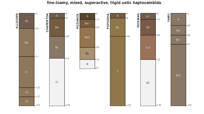
| Poposhia-Trimad complex, 3 to 15 percent slopes | 129 | 348 | 497628 | jptj | co644 | 1980 | 1:24000 |
Poposhia silt loam, 0 to 6 percent slopes | 200 | 740 | 104434 | 3hnv | wy031 | 1998 | 1:24000 |
Poposhia-Chaperton association, 6 to 12 percent slopes | 203 | 455 | 104557 | 3hst | wy031 | 1998 | 1:24000 |
Poposhia-Forelle complex, 1 to 8 percent slopes | 204 | 369 | 104559 | 3hsw | wy031 | 1998 | 1:24000 |
Poposhia-Blazon silt loams, 3 to 30 percent slopes | 201 | 66 | 104435 | 3hnw | wy031 | 1998 | 1:24000 |
Poposhia-Blazon, thin solum-Rock outcrop complex, 5 to 35 percent slopes | 202 | 4 | 104436 | 3hnx | wy031 | 1998 | 1:24000 |
Poposhia loam, 0 to 3 percent slopes | 161 | 824 | 1862617 | 20j6f | wy041 | | 1:24000 |
Obadia-Poposhia association, 0 to 3 percent slopes | 182 | 548 | 1862620 | 20j6j | wy041 | | 1:24000 |
Poposhia loam, 6 to 10 percent slopes | 3534C | 351 | 2484094 | 2pcx2 | wy041 | | 1:24000 |
Poposhia-Forelle complex, 1 to 8 percent slopes | 198 | 63638 | 501742 | jv37 | wy601 | 1991 | 1:24000 |
Poposhia-Chaperton association, 6 to 12 percent slopes | 199 | 38339 | 501743 | jv38 | wy601 | 1991 | 1:24000 |
Chaperton-Poposhia complex, 3 to 30 percent slopes | 140 | 5003 | 501677 | jv14 | wy601 | 1991 | 1:24000 |
Poposhia-Blazon complex, 3 to 15 percent slopes | 197 | 4188 | 501741 | jv36 | wy601 | 1991 | 1:24000 |
Poposhia-Blazon complex, 3 to 15 percent slopes | 240 | 2339 | 502366 | jvrc | wy625 | 1985 | 1:24000 |
Poposhia-Havre overflow complex, 0 to 6 percent slopes -- draft | 406 | 9828 | 2421005 | 2m87y | wy630 | | 1:24000 |
Poposhia loam, 2 to 6 percent slopes -- draft | 349AB | 4784 | 2378259 | 2kts1 | wy630 | | 1:24000 |
Tisworth-Poposhia complex, 0 to 8 percent slopes -- draft | 414 | 3602 | 2455475 | 2nf3w | wy630 | | 1:24000 |
Poposhia loam, 0 to 2 percent slopes -- draft | 349A | 362 | 2393893 | 2lc1c | wy630 | | 1:24000 |
Poposhia-Redgap-Sweetlette complex, 0 to 10 percent slopes | 2243 | 1203 | 2554737 | 2rc08 | wy635 | | 1:24000 |
Poposhia loam, 3 to 6 percent slopes | 162 | 7567 | 504021 | jxgr | wy638 | 1990 | 1:24000 |
Poposhia clay loam, 0 to 3 percent slopes | 164 | 2534 | 504023 | jxgt | wy638 | 1990 | 1:24000 |
Poposhia loam, 0 to 3 percent slopes | 161 | 2160 | 504019 | jxgp | wy638 | 1990 | 1:24000 |
Poposhia loam, 6 to 10 percent slopes | 163 | 2076 | 504022 | jxgs | wy638 | 1990 | 1:24000 |
Delphill-Iyers-Poposhia complex, 3 to 25 percent slopes | 119 | 1478 | 503962 | jxdv | wy638 | 1990 | 1:24000 |
Spicerton-Poposhia complex, 0 to 3 percent slopes | 182 | 1256 | 504045 | jxhj | wy638 | 1990 | 1:24000 |
Poposhia very fine sandy loam, strongly alkaline, 1 to 3 percent slopes | 166 | 774 | 504025 | jxgw | wy638 | 1990 | 1:24000 |
Poposhia clay loam, 3 to 6 percent slopes | 165 | 734 | 504024 | jxgv | wy638 | 1990 | 1:24000 |
Poposhia-Blazon-Carmody complex, 3 to 45 percent slopes | 045 | 24126 | 157574 | 58z1 | wy647 | | 1:24000 |
Forelle-Poposhia loams, 2 to 12 percent slopes | 294 | 12116 | 157478 | 58vy | wy647 | | 1:24000 |
Poposhia loam, 1 to 6 percent slopes | 043 | 9053 | 157544 | 58y2 | wy647 | | 1:24000 |
Poposhia-Grieves complex, 0 to 6 percent slopes | 046 | 3852 | 157573 | 58z0 | wy647 | | 1:24000 |
Gypsids-Poposhia gravelly loams, 0 to 6 percent slopes | 089 | 2543 | 157714 | 593k | wy647 | | 1:24000 |
Forelle-Poposhia association, 2 to 12 percent slopes | 53 | 2182 | 1901555 | 21tqh | wy677 | 1975 | 1:24000 |
Poposhia-Blazon-Carmody complex, hilly | 55 | 2055 | 1901571 | 21tr0 | wy677 | 1975 | 1:24000 |
Poposhia loam, 1 to 6 percent slopes | 51 | 97 | 1901570 | 21tqz | wy677 | 1975 | 1:24000 |
Forelle-Poposhia association, 2 to 12 percent slopes | 148 | 47793 | 503013 | jwf7 | wy713 | 1986 | 1:24000 |
Poposhia-Blazon-Carmody complex, hilly | 186 | 47347 | 503051 | jwgg | wy713 | 1986 | 1:24000 |
Poposhia, sodic-Blazon complex, rolling | 187 | 9709 | 503052 | jwgh | wy713 | 1986 | 1:24000 |
Sandbranch-Ryan Park variant-Poposhia complex, 1 to 8 percent slopes | 206 | 3654 | 503079 | jwhc | wy713 | 1986 | 1:24000 |
Absher-Poposhia-Sinkson complex, 1 to 10 percent slopes | 101 | 2685 | 502959 | jwch | wy713 | 1986 | 1:24000 |
Tisworth-Poposhia complex, undulating | 213 | 2351 | 503090 | jwhq | wy713 | 1986 | 1:24000 |
Poposhia loam, 1 to 6 percent slopes | 185 | 1224 | 503050 | jwgf | wy713 | 1986 | 1:24000 |
Poposhia-Trimad complex, 3 to 15 percent slopes | 162 | 52750 | 104963 | 3j6x | wy721 | 1994 | 1:24000 |
Poposhia silt loam, 0 to 6 percent slopes | 158 | 15571 | 104959 | 3j6s | wy721 | 1994 | 1:24000 |
Poposhia-Blazon, thin solum-Rock outcrop complex, 5 to 35 percent slopes | 160 | 8873 | 104961 | 3j6v | wy721 | 1994 | 1:24000 |
Poposhia-Blazon silt loams, 3 to 30 percent slopes | 159 | 7590 | 104960 | 3j6t | wy721 | 1994 | 1:24000 |
Urban land-Poposhia-Trimad complex, 3 to 15 percent slopes | 189 | 5934 | 104990 | 3j7s | wy721 | 1994 | 1:24000 |
Trimad-Poposhia complex, dry, 6 to 15 percent slopes | 179 | 5888 | 104980 | 3j7g | wy721 | 1994 | 1:24000 |
Urban land-Poposhia complex, 0 to 6 percent slopes | 188 | 5025 | 104989 | 3j7r | wy721 | 1994 | 1:24000 |
Blazon-Blazon, thin solum-Poposhia silt loams, 0 to 6 percent slopes | 108 | 4695 | 104909 | 3j55 | wy721 | 1994 | 1:24000 |
Poposhia-Piezon silt loams, 0 to 6 percent slopes | 161 | 3758 | 104962 | 3j6w | wy721 | 1994 | 1:24000 |
Forelle, moderately deep-Rock River-Poposhia complex, 0 to 6 percent slopes -- draft | 7141 | 23936 | 2518744 | 2q048 | wy723 | | 1:24000 |
Sandbranch taxadjunct-Cumberhill-Poposhia complex, 4 to 15 percent slopes | 6338 | 17667 | 3073238 | 2xgc5 | wy723 | | 1:24000 |
Poposhia-Lamanga taxadjunct complex, 0 to 2 percent slopes | 1117 | 1237 | 3160901 | 2yx3f | wy723 | | 1:24000 |
Scooby-Obadia-Poposhia complex, 1 to 6 percent slopes | 2429 | 1189 | 2611920 | 2l3f6 | wy723 | | 1:24000 |
Poposhia family-Thenipel complex, 1 to 4 percent slopes | 6352 | 889 | 3406617 | 316q1 | wy723 | | 1:24000 |
Poposhia-Scooby-Belleplain taxadjunct complex, 1 to 4 percent slopes | 6351 | 449 | 3406616 | 316q0 | wy723 | | 1:24000 |
Scooby-Obadia-Poposhia complex, 1 to 6 percent slopes | 2429 | 37180 | 2572303 | 2l3f6 | wy737 | | 1:24000 |
Poposhia-Forelle-Scooby complex, 0 to 6 percent slopes | 4424 | 28769 | 3406459 | 3133l | wy737 | | 1:24000 |
Poposhia-Hawkstone-Redcreek family, complex, 1 to 8 percent slopes | 4421 | 21995 | 3406456 | 3133h | wy737 | | 1:24000 |
Slipperyjim-Poposhia-Thenipel complex, 1 to 8 percent slopes | 4239 | 19840 | 3222511 | 30j6y | wy737 | | 1:24000 |
Poposhia, sodic surface-Poposhia-Blanfort complex, 1 to 15 percent slopes | 4245 | 6224 | 3406446 | 316pd | wy737 | | 1:24000 |
Poposhia-Redgap-Sweetlette complex, 0 to 10 percent slopes | 2243 | 4211 | 2554730 | 2rc08 | wy737 | | 1:24000 |
Poposhia family-Schrute-Redgap complex, 2 to 8 percent slopes | 4129 | 3358 | 3406432 | 31d7y | wy737 | | 1:24000 |
Chanute-Colnevee taxadjunct-Poposhia family complex, 2 to 8 percent slopes | 4223 | 672 | 3222348 | 30j6f | wy737 | | 1:24000 |
Blackhall-Blazon-Poposhia complex, 3 to 30 percent slopes -- draft | 590 | 83 | 2572292 | jx2s | wy737 | | 1:24000 |


