Amanda silt loam, 18 to 25 percent slopes, eroded
gravelly surface layer
(%)
Hydric:
PAWS: NA
severely eroded areas
(%)
Hydric:
PAWS: NA
gravelly upper subsoil
(%)
Hydric:
PAWS: NA
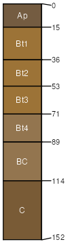
Amanda
(85%)
Till Ridge
Typic Hapludalfs
Well drained
Hydric: No
PAWS: 29 cm
end moraines / Backslope
sandstone or shale bedrock at 40 to 80 inches
(4%)
Hydric:
PAWS: NA
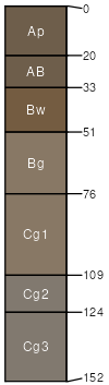
Shoals
(4%)
Wet Alluvium Forest
Hydric:
PAWS: NA
flood plains
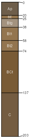
Bennington
(4%)
Wet Till Ridge
Hydric:
PAWS: NA
ground moraines
flats
slopes of 25 to 40 percent
(3%)
Hydric:
PAWS: NA
SSA
Scale
Published
Export
oh117
1:16,000
1986
2025-09-02