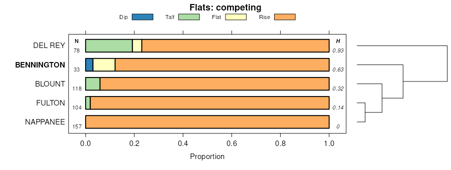
| Bennington silt loam, 2 to 6 percent slopes | BnB | 24385 | 288129 | 2t6mb | oh005 | 1976 | 1:15840 |
Bennington silt loam, 0 to 2 percent slopes | BnA | 11530 | 288128 | 2t6m9 | oh005 | 1976 | 1:15840 |
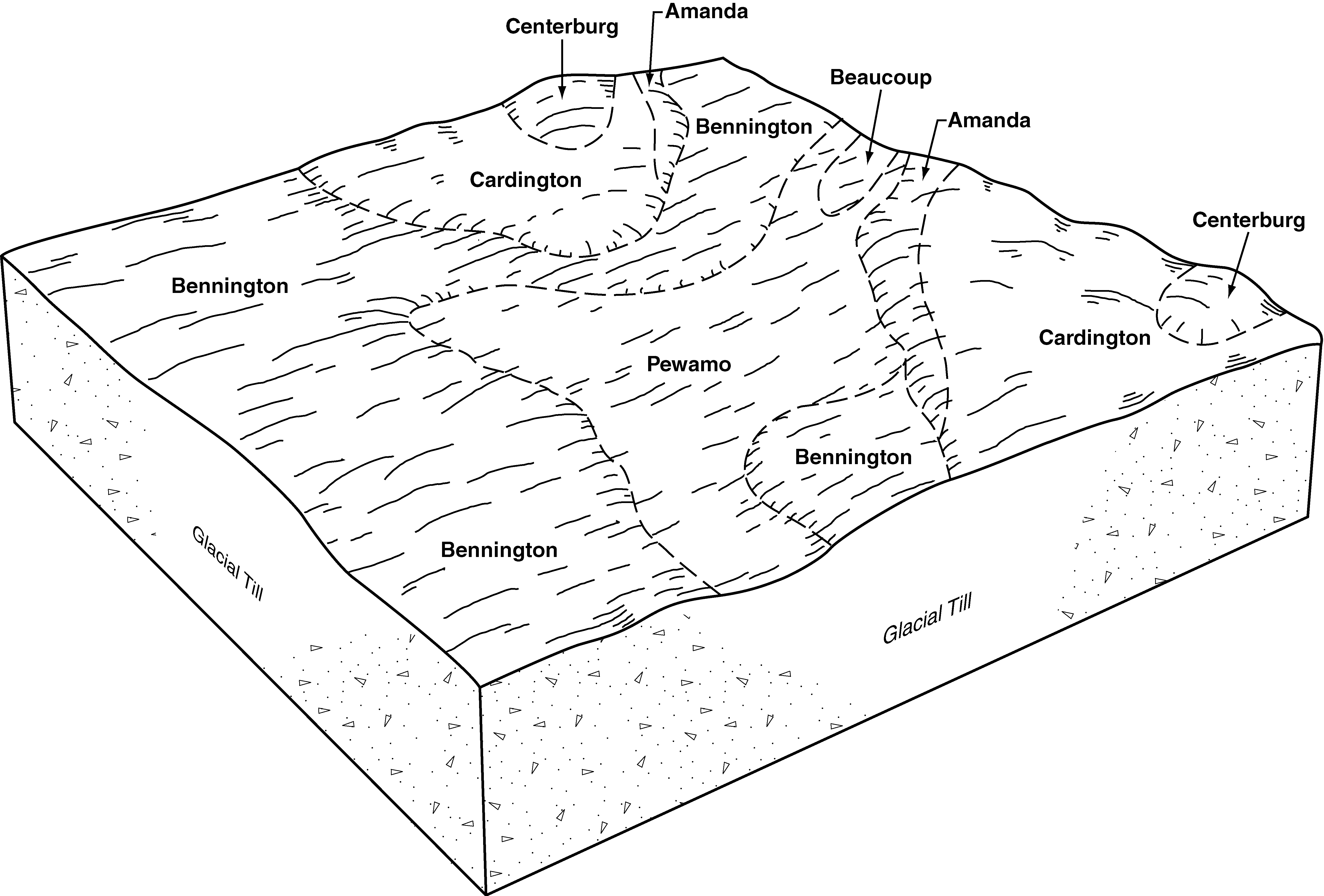
Bennington-Tiro silt loams, 0 to 2 percent slopes | BoA | 56 | 1592642 | 1qg8k | oh005 | 1976 | 1:15840 |
Bennington silt loam, 2 to 6 percent slopes, moderately eroded | BnB2 | 2 | 1592604 | 1qg7b | oh005 | 1976 | 1:15840 |
Bennington silt loam, 2 to 6 percent slopes | BgB | 34011 | 168539 | 2t6mb | oh033 | 1975 | 1:15840 |
Condit-Bennington silt loams | Cr | 25122 | 168557 | 5ndb | oh033 | 1975 | 1:15840 |
Bennington silt loam, 0 to 2 percent slopes | BeA | 20403 | 1019357 | 2t6m9 | oh033 | 1975 | 1:15840 |
Bennington-Urban land complex, 0 to 6 percent slopes | BhB | 2340 | 168540 | 2t6ml | oh033 | 1975 | 1:15840 |
Tuscola-Bennington complex, 2 to 6 percent slopes | TuB | 610 | 168596 | 5nfl | oh033 | 1975 | 1:15840 |
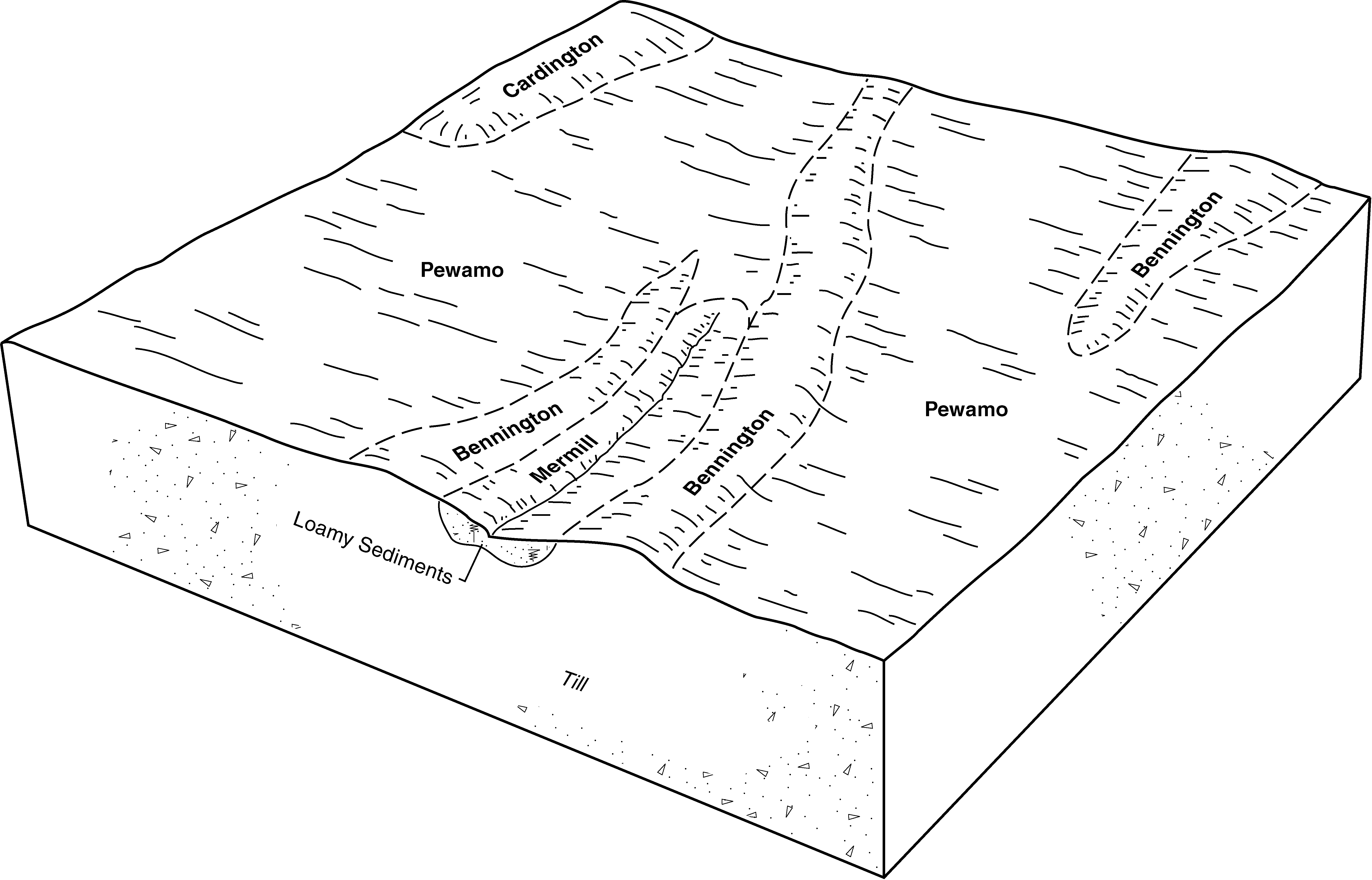
Kibbie-Bennington complex, 2 to 6 percent slopes | KcB | 537 | 168574 | 5ndw | oh033 | 1975 | 1:15840 |
Bennington silt loam, 2 to 6 percent slopes, eroded | BgB2 | 25 | 1019358 | 136qj | oh033 | 1975 | 1:15840 |
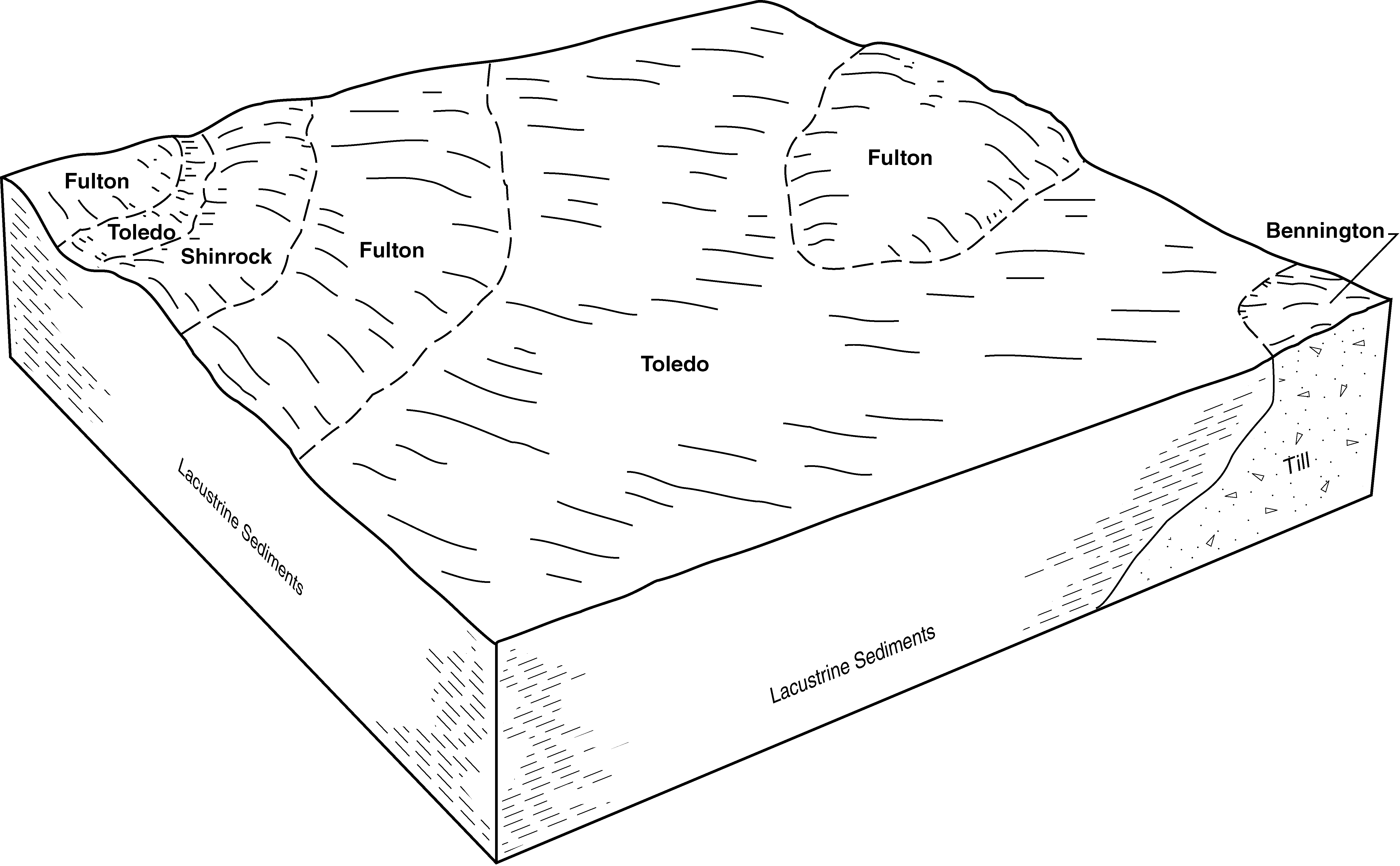
Bennington-Fitchville silt loams, 2 to 6 percent slopes | BkB | 9 | 1019359 | 136qk | oh033 | 1975 | 1:15840 |
Bennington silt loam, 0 to 2 percent slopes | BeA | 27485 | 172038 | 2t6m9 | oh041 | 1997 | 1:12000 |
Bennington silt loam, 2 to 6 percent slopes | BeB | 14369 | 172039 | 2t6mb | oh041 | 1997 | 1:12000 |
Bennington silt loam, 0 to 2 percent slopes | BgA | 10306 | 172111 | 2t6m9 | oh043 | 1998 | 1:12000 |
Bennington loam, 0 to 2 percent slopes | BeA | 1651 | 172110 | 5s2y | oh043 | 1998 | 1:12000 |
Bennington silt loam, 2 to 6 percent slopes | BgB | 1467 | 172112 | 2t6mb | oh043 | 1998 | 1:12000 |
Bennington silt loam, 0 to 2 percent slopes | BeA | 23920 | 172224 | 2t6m9 | oh045 | 1998 | 1:12000 |
Bennington silt loam, 2 to 6 percent slopes | BeB | 4642 | 172225 | 2t6mb | oh045 | 1998 | 1:12000 |
Urban land-Bennington complex, 0 to 6 percent slopes | UrB | 1463 | 172320 | 2t6mm | oh045 | 1998 | 1:12000 |
Bennington-Urban land complex, 0 to 2 percent slopes | BfA | 20653 | 167873 | 2t6mc | oh049 | 1977 | 1:15840 |
Bennington silt loam, 2 to 6 percent slopes | BeB | 17773 | 167872 | 2t6mb | oh049 | 1977 | 1:15840 |
Bennington-Urban land complex, 0 to 6 percent slopes | BfB | 12719 | 167874 | 2t6ml | oh049 | 1977 | 1:15840 |
Bennington silt loam, 0 to 2 percent slopes | BeA | 9993 | 167871 | 2t6m9 | oh049 | 1977 | 1:15840 |
Urban land-Bennington complex, 0 to 6 percent slopes | Uu | 2541 | 167944 | 2t6mm | oh049 | 1977 | 1:15840 |
Bennington silt loam, 0 to 3 percent slopes | BeA | 157 | 1398051 | 1hxsf | oh073 | 1986 | 1:15840 |
Bennington silt loam, 0 to 2 percent slopes | BcA | 4 | 1398176 | 2t6m9 | oh073 | 1986 | 1:15840 |
Bennington silt loam, 2 to 6 percent slopes | BcB | 1 | 1398177 | 2t6mb | oh073 | 1986 | 1:15840 |
Bennington silt loam, 0 to 2 percent slopes | BgA | 100995 | 167956 | 2t6m9 | oh077 | 1988 | 1:15840 |
Bennington silt loam, 2 to 6 percent slopes | BgB | 20677 | 167957 | 2t6mb | oh077 | 1988 | 1:15840 |
Bennington silt loam, 2 to 6 percent slopes, moderately eroded | BgB2 | 10 | 1605962 | 1qx47 | oh077 | 1988 | 1:15840 |
Bennington silt loam, 2 to 6 percent slopes | BnB | 21721 | 613551 | 2t6mb | oh083 | 1983 | 1:15840 |
Bennington silt loam, 0 to 2 percent slopes | BnA | 3758 | 613550 | 2t6m9 | oh083 | 1983 | 1:15840 |
Bennington silt loam, 2 to 6 percent slopes | BeB | 37830 | 170995 | 2t6mb | oh089 | 1986 | 1:15840 |
Bennington silt loam, 0 to 2 percent slopes | BeA | 25265 | 170994 | 2t6m9 | oh089 | 1986 | 1:15840 |
Bennington-Urban land complex, 0 to 2 percent slopes | BfA | 1480 | 170996 | 2t6mc | oh089 | 1986 | 1:15840 |
Bennington silt loam, 0 to 2 percent slopes | BgA | 2326 | 1605797 | 2t6m9 | oh093 | 1972 | 1:15840 |
Bennington silt loam, 2 to 6 percent slopes | BgB | 624 | 1605798 | 2t6mb | oh093 | 1972 | 1:15840 |
Bennington silt loam, 2 to 6 percent slopes | BeB | 1772 | 816722 | wdvw | oh099 | 1966 | 1:15840 |
Bennington silt loam, 0 to 2 percent slopes | BfA | 7257 | 1400448 | 2t6m9 | oh101 | 1984 | 1:15840 |
Bennington silt loam, 2 to 6 percent slopes | BnB | 16210 | 288306 | 2t6mb | oh103 | 1974 | 1:15840 |
Bennington silt loam, 0 to 2 percent slopes | BnA | 6414 | 288305 | 2t6m9 | oh103 | 1974 | 1:15840 |
Bennington-Tiro silt loams, 0 to 2 percent slopes | BoA | 4884 | 288307 | 9p07 | oh103 | 1974 | 1:15840 |
Bennington silt loam, 0 to 2 percent slopes | BeA | 25281 | 170337 | 2t6m9 | oh117 | 1986 | 1:15840 |
Bennington silt loam, 2 to 6 percent slopes | BeB | 9970 | 170338 | 2t6mb | oh117 | 1986 | 1:15840 |
Bennington silt loam, 0 to 3 percent slopes | BeA | 1082 | 537500 | l19q | oh127 | 1984 | 1:15840 |
Bennington silt loam, 0 to 2 percent slopes | BnA | 799 | 171232 | 2t6m9 | oh129 | 1977 | 1:15840 |
Bennington silt loam, 2 to 6 percent slopes | BnB | 734 | 171233 | 2t6mb | oh129 | 1977 | 1:15840 |
Bennington silt loam, 2 to 6 percent slopes | BnB | 37132 | 170719 | 2t6mb | oh139 | 1971 | 1:15840 |
Bennington silt loam, 0 to 2 percent slopes | BnA | 13167 | 170718 | 2t6m9 | oh139 | 1971 | 1:15840 |
Bennington silt loam, 2 to 6 percent slopes, moderately eroded | BnB2 | 2091 | 170720 | 5qn3 | oh139 | 1971 | 1:15840 |
Fitchville-Bennington silt loams, 0 to 2 percent slopes | FdA | 1243 | 170752 | 5qp4 | oh139 | 1971 | 1:15840 |
Bennington-Fitchville silt loams, 2 to 6 percent slopes | BpB | 328 | 170721 | 5qn4 | oh139 | 1971 | 1:15840 |
Condit-Bennington silt loams | Cs | 2 | 1406543 | 1j6mc | oh139 | 1971 | 1:15840 |
Bennington silt loam, 0 to 2 percent slopes | BeA | 501 | 169550 | 2t6m9 | oh143 | 1983 | 1:15840 |
Bennington silt loam, 2 to 6 percent slopes | BgB | 1639 | 169964 | 2t6mb | oh147 | 1978 | 1:15840 |
Bennington silt loam, 2 to 6 percent slopes, eroded | BgB2 | 1135 | 169965 | 5pvr | oh147 | 1978 | 1:15840 |
Bennington silt loam, 0 to 2 percent slopes | BgA | 3 | 1592179 | 2t6m9 | oh147 | 1978 | 1:15840 |
Bennington silt loam, 2 to 6 percent slopes | BnB | 7350 | 287159 | 2t6mb | oh169 | 1981 | 1:15840 |
Bennington silt loam, 0 to 2 percent slopes | BnA | 2066 | 287158 | 2t6m9 | oh169 | 1981 | 1:15840 |
Bennington silt loam, 2 to 6 percent slopes | BgB | 2950 | 169595 | 2t6mb | oh175 | 1980 | 1:15840 |
Bennington silt loam, 0 to 2 percent slopes | BgA | 2901 | 169594 | 2t6m9 | oh175 | 1980 | 1:15840 |
Kibbie-Bennington complex, 2 to 6 percent slopes | KdB | 5 | 1542628 | 1ns76 | oh175 | 1980 | 1:15840 |
