Brownsto-McFadden-Rock outcrop complex, 5 to 60 percent slopes
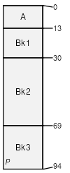
Brownsto
(40%)
Coarse Upland (CU) 10-14 East Precipitation Zone
Ustic Haplocalcids
Well drained
Hydric: No
PAWS: 18 cm
hills / Backslope
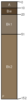
McFadden
(30%)
Gravelly (Gr) 10-14 East Precipitation Zone
Ustic Haplocalcids
Well drained
Hydric: No
PAWS: 18 cm
fan aprons / Shoulder
Rock outcrop
(15%)
Hydric: No
PAWS: NA
hillsides
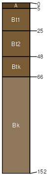
Rock River
(4%)
Sandy High Plains Southeast (Sy)
Ustic Calciargids
Well drained
Hydric: No
PAWS: 21 cm
terraces
Lupinto
(4%)
Loamy (Ly) 10-14 East Precipitation Zone
Ustic Calciargids
Well drained
Hydric: No
PAWS: 17 cm
terraces
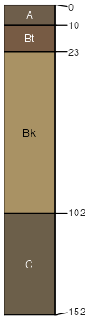
Bosler
(4%)
Sandy High Plains Southeast (Sy)
Ustic Calciargids
Well drained
Hydric: No
PAWS: 15 cm
terraces
Dahlquist
(3%)
Coarse Upland (CU) 10-14 East Precipitation Zone
Ustic Calciargids
Well drained
Hydric: No
PAWS: 13 cm
fans
SSA
Scale
Published
Export
wy647
1:24,000
2025-09-04