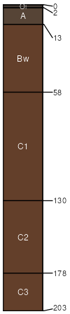
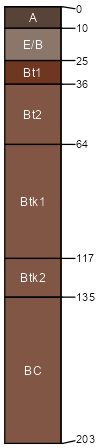
Rockland (65%)
Loamy Uplands
Typic Eutrudepts
Well drained
Hydric: No
PAWS: 40 cm |
slumps / Summit slumps / Shoulder slumps / Backslope slumps / Footslope slumps / Toeslope
|
|
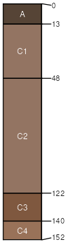
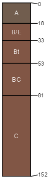
Moquah (15%)
Seasonally Dry Floodplains
Typic Udifluvents
Moderately well drained
Hydric: No
PAWS: 31 cm |
flood plains / Summit flood plains / Shoulder flood plains / Backslope flood plains / Footslope flood plains / Toeslope
|
|
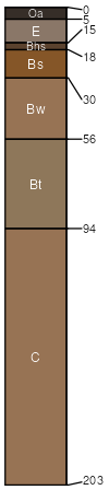
Zandi (7%)
Loamy Uplands
Lamellic Haplorthods
Well drained
Hydric: No
PAWS: 29 cm |
till-floored lake plains / Summit till-floored lake plains / Shoulder till-floored lake plains / Backslope till-floored lake plains / Footslope till-floored lake plains / Toeslope
|
|
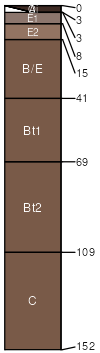
Watton (5%)
Loamy Uplands
Typic Glossudalfs
Well drained
Hydric: No
PAWS: 25 cm |
till plains / Summit till plains / Shoulder till plains / Backslope till plains / Footslope till plains / Toeslope
|
|
Miskoaki (5%)
Clayey Uplands
Vertic Glossudalfs
Well drained
Hydric: No
PAWS: 21 cm |
till plains / Summit till plains / Shoulder till plains / Backslope till plains / Footslope till plains / Toeslope
|
|
Ontonagon (3%)
Moist Clayey Lowlands
Haplic Glossudalfs
Well drained
Hydric: No
PAWS: 34 cm |
slumps lake plains / Summit lake plains / Shoulder lake plains / Backslope lake plains / Footslope lake plains / Toeslope
|
|