Summit (55%)
Clayey Upland
Oxyaquic Vertic Argiudolls
Moderately well drained
Hydric: No
PAWS: 24 cm |
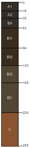
interfluves / Backslope interfluves / Shoulder
|
|
Eram (30%)
Clayey Upland
Aquic Argiudolls
Moderately well drained
Hydric: No
PAWS: 10 cm |
interfluves / Backslope interfluves / Shoulder
|
|
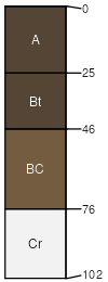
Clareson (5%)
Gravelly Upland
Typic Argiudolls
Well drained
Hydric: No
PAWS: 4 cm |

|
|
Dennis (5%)
Loamy Upland
Aquic Argiudolls
Moderately well drained
Hydric: No
PAWS: 29 cm |
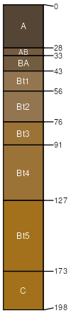
|
|
Kenoma (5%)
Claypan Upland
Vertic Argiudolls
Moderately well drained
Hydric: No
PAWS: 18 cm |
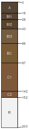
|
|