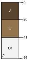
Valent (50%)
Sands (Sa)
Ustic Torripsamments
Excessively drained
Hydric: No
PAWS: 24 cm |

dunes / Backslope dunes / Summit
|
|
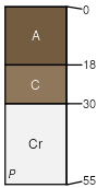
Treon (30%)
Shallow (Sw)
Torriorthentic Haplustolls
Well drained
Hydric: No
PAWS: 6 cm |

|
|
Vetal (4%)
Sandy (Sy)
Pachic Haplustolls
Well drained
Hydric: No
PAWS: 26 cm |

|
|
Aberone (4%)
Sandy (Sy)
Aridic Haplustolls
Well drained
Hydric: No
PAWS: 14 cm |

hillslopes / Toeslope hillslopes / Footslope hillslopes / Backslope
|
|
Otero (4%)
Sandy (Sy)
Aridic Ustorthents
Well drained
Hydric: No
PAWS: 24 cm |

|
|
Tassel (4%)
Shallow (Sw)
Ustic Torriorthents
Well drained
Hydric: No
PAWS: 4 cm |

ridges / Shoulder ridges / Summit
|
|
Rock outcrop (4%)
Hydric: No
PAWS: NA |

|
|