| Vetal very fine sandy loam, 0 to 3 percent slopes | 5290 | 10474 | 1692525 | 1tt6l | ne007 | 1988 | 1:20000 |
Vetal fine sandy loam, 3 to 6 percent slopes | 5282 | 567 | 1692524 | 1tt6k | ne007 | 1988 | 1:20000 |
Vetal very fine sandy loam, 0 to 3 percent slopes | 5290 | 1613 | 1699512 | 2zbf3 | ne009 | 1988 | 1:20000 |
Vetal loamy fine sand, 3 to 6 percent slopes | 5289 | 197 | 1699511 | 2zzbl | ne009 | 1988 | 1:20000 |
Vetal fine sandy loam, 0 to 3 percent slopes | 5281 | 7114 | 357839 | 2tzzm | ne013 | 1980 | 1:20000 |
Vetal fine sandy loam, 3 to 6 percent slopes | 5282 | 783 | 357840 | d0c7 | ne013 | 1980 | 1:20000 |
Vetal loam, 1 to 3 percent slopes | 5286 | 1468 | 100044 | 2zbfg | ne017 | 1987 | 1:20000 |
Vetal fine sandy loam, 0 to 3 percent slopes | 5281 | 10 | 2219179 | 2zbf4 | ne017 | 1987 | 1:20000 |
Vetal fine sandy loam, 0 to 3 percent slopes | 5281 | 5730 | 1699072 | 1v10s | ne029 | 1980 | 1:20000 |
Vetal fine sandy loam, 0 to 3 percent slopes | 5281 | 6038 | 100459 | 2zbf4 | ne031 | 1995 | 1:24000 |
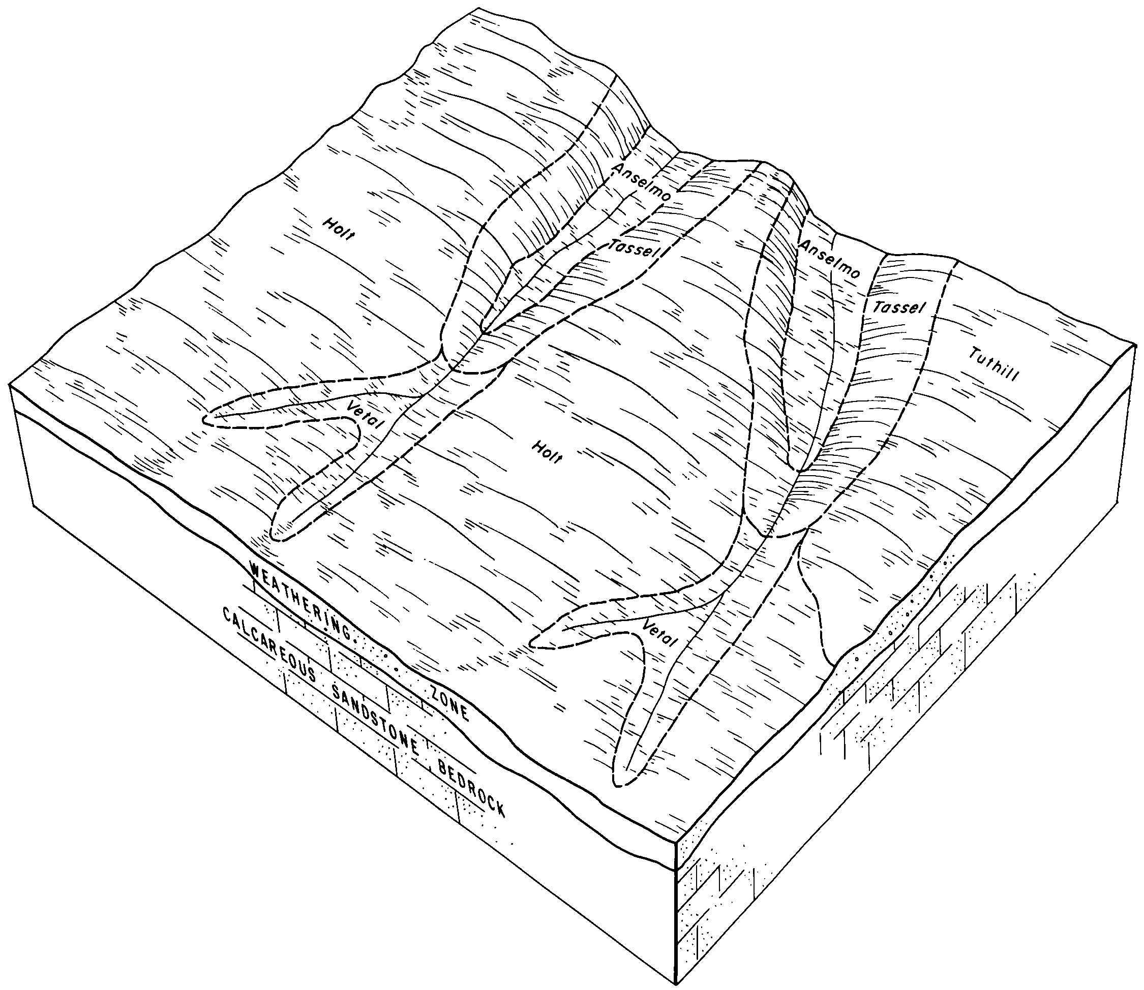
Holt-Vetal fine sandy loams, 0 to 6 percent slopes | 3176 | 2413 | 100394 | 3cgj | ne031 | 1995 | 1:24000 |
Vetal loamy fine sand, 0 to 3 percent slopes | 5288 | 928 | 100458 | 2zbf2 | ne031 | 1995 | 1:24000 |
Vetal and Bayard soils, 1 to 6 percent slopes | 5070 | 12294 | 358176 | d0q2 | ne045 | 1973 | 1:20000 |
Sarben and Vetal loamy very fine sands, 9 to 30 percent slopes | 6090 | 7005 | 358164 | d0pp | ne045 | 1973 | 1:20000 |
Jayem and Vetal loamy very fine sands, 6 to 9 percent slopes | 5964 | 3238 | 358112 | d0n0 | ne045 | 1973 | 1:20000 |
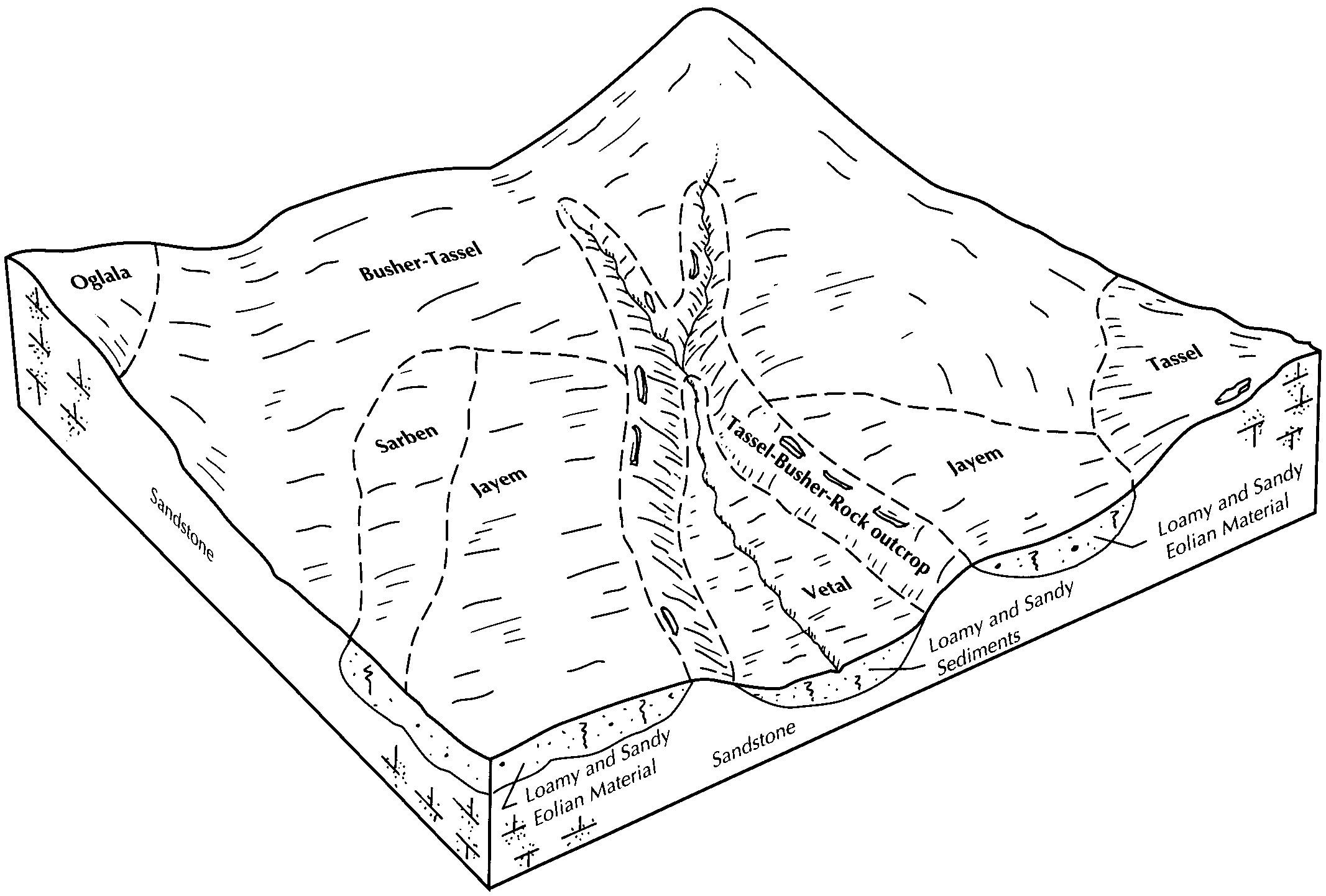
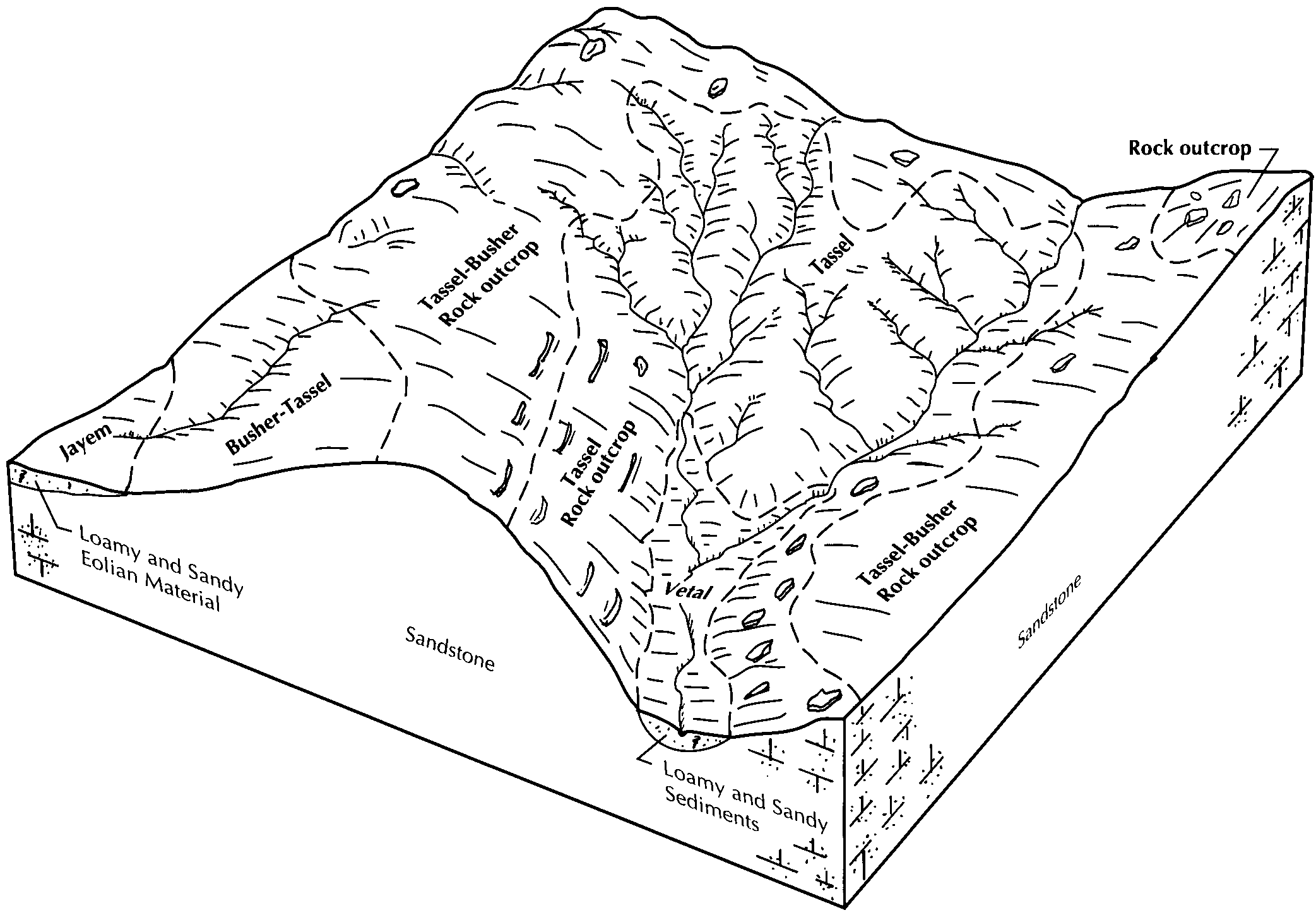
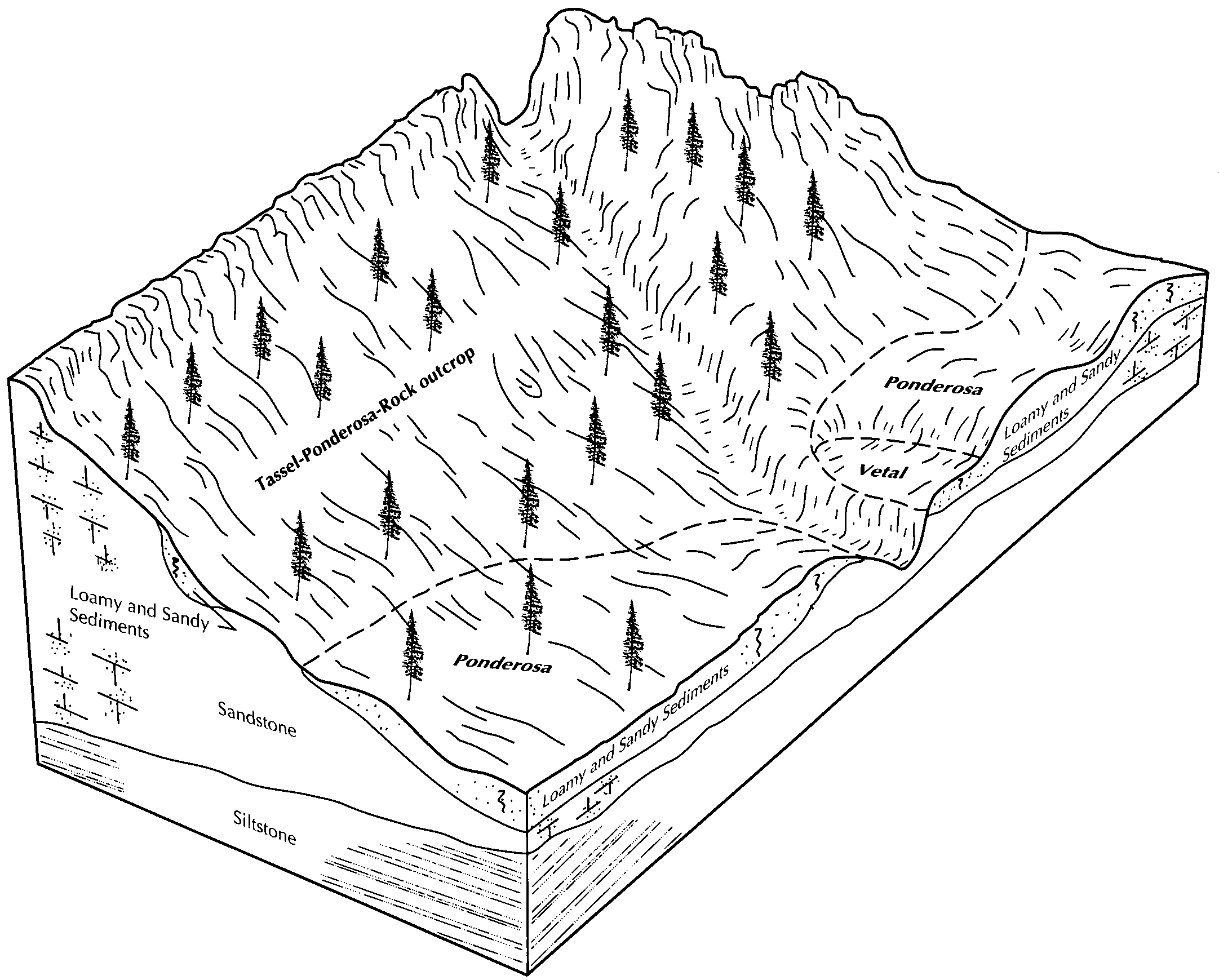
Ponderosa-Tassel-Vetal complex, 6 to 30 percent slopes | 5234 | 704 | 2217529 | 2wcbh | ne045 | 1973 | 1:20000 |
Vetal very fine sandy loam, 3 to 6 percent slopes | 5292 | 463 | 2217536 | 30wq3 | ne045 | 1973 | 1:20000 |
Vetal fine sandy loam, 0 to 3 percent slopes | 5281 | 389 | 2217534 | 2tzzm | ne045 | 1973 | 1:20000 |
Vetal fine sandy loam, 3 to 6 percent slopes | 5282 | 173 | 2217579 | 2dfkt | ne045 | 1973 | 1:20000 |
Vetal very fine sandy loam, 1 to 3 percent slopes | 5291 | 115 | 2217535 | 30wq2 | ne045 | 1973 | 1:20000 |
Vetal loamy fine sand, 0 to 3 percent slopes | 5288 | 4 | 2217562 | 2dfk8 | ne045 | 1973 | 1:20000 |
Vetal fine sandy loam, 0 to 3 percent slopes | 5281 | 4963 | 1698784 | 2tzzm | ne069 | 1995 | 1:20000 |
Vetal loamy fine sand, 0 to 3 percent slopes | 5288 | 11493 | 1698927 | 1v0w3 | ne101 | 1990 | 1:20000 |
Vetal loam, 0 to 1 percent slopes | 5285 | 3534 | 357752 | d08d | ne103 | 1977 | 1:20000 |
Vetal fine sandy loam, 0 to 3 percent slopes | 5281 | 3063 | 357751 | 2zbf4 | ne103 | 1977 | 1:20000 |
Vetal loam, 1 to 3 percent slopes | 5286 | 1271 | 357753 | 2zbfg | ne103 | 1977 | 1:20000 |
Vetal loam, 3 to 6 percent slopes | 5287 | 485 | 357754 | d08g | ne103 | 1977 | 1:20000 |
Vetal fine sandy loam, loamy substratum, 0 to 3 percent slopes | 5283 | 2957 | 1699225 | 1v15q | ne111 | 1971 | 1:24000 |
Vetal loamy fine sand, 0 to 3 percent slopes | 5288 | 121 | 2219742 | 2dhtl | ne111 | 1971 | 1:24000 |
Vetal fine sandy loam, 0 to 3 percent slopes | 5281 | 8 | 2219791 | 2dhw5 | ne111 | 1971 | 1:24000 |
Vetal fine sandy loam | 5280 | 403 | 1699389 | 1v1c0 | ne113 | 1969 | 1:24000 |
Vetal very fine sandy loam, 0 to 3 percent slopes | 5290 | 401 | 2219827 | 2zbf3 | ne115 | 1986 | 1:20000 |
Vetal fine sandy loam, 0 to 3 percent slopes | 5281 | 7078 | 1692675 | 2tzzm | ne123 | 1981 | 1:20000 |
Vetal fine sandy loam, 0 to 3 percent slopes | 5281 | 3128 | 1699000 | 1v0yg | ne135 | 1987 | 1:20000 |
Vetal loamy fine sand, 0 to 3 percent slopes | 5288 | 147 | 2219567 | 2dhmy | ne135 | 1987 | 1:20000 |
Vetal loam, 1 to 3 percent slopes | 5286 | 1193 | 100269 | 2zbfg | ne149 | 1982 | 1:20000 |
Vetal fine sandy loam, 0 to 3 percent slopes | 5281 | 29 | 2227664 | 2tzzm | ne157 | 1965 | 1:20000 |
Ponderosa-Tassel-Vetal complex, 6 to 30 percent slopes | 5234 | 43179 | 100630 | 2wcbh | ne161 | 1992 | 1:20000 |
Vetal fine sandy loam, 0 to 3 percent slopes | 5281 | 14293 | 100661 | 2tzzm | ne161 | 1992 | 1:20000 |
Vetal loamy fine sand, 0 to 3 percent slopes | 5288 | 4134 | 100660 | 2zbf2 | ne161 | 1992 | 1:20000 |
Ponderosa-Tassel-Vetal complex, 6 to 30 percent slopes | 5234 | 26170 | 357998 | 2wcbh | ne165 | 1993 | 1:20000 |
Vetal very fine sandy loam, 1 to 3 percent slopes | 5291 | 15336 | 358056 | 30wq2 | ne165 | 1993 | 1:20000 |
Vetal very fine sandy loam, 3 to 6 percent slopes | 5292 | 7960 | 358057 | 30wq3 | ne165 | 1993 | 1:20000 |
Vetal fine sandy loam, 0 to 3 percent slopes | 5281 | 1182 | 358053 | 2tzzm | ne165 | 1993 | 1:20000 |
Vetal-Holt fine sandy loams, 6 to 15 percent slopes | VhD | 5330 | 352768 | cv2m | sd007 | 2004 | 1:20000 |
Vetal-Mobridge complex, 0 to 3 percent slopes | VgA | 4053 | 352767 | cv2l | sd007 | 2004 | 1:20000 |
Vetal fine sandy loam, 0 to 3 percent slopes | T175A | 158 | 1390137 | 2zbf4 | sd007 | 2004 | 1:20000 |
Vetal loamy fine sand, 0 to 3 percent slopes | T176A | 110 | 1390138 | 2zbf2 | sd007 | 2004 | 1:20000 |
Vetal fine sandy loam, 0 to 3 percent slopes | Vt | 855 | 355300 | 2zzwc | sd053 | 1982 | 1:20000 |
Holt-Vetal fine sandy loams, 3 to 9 percent slopes | HlC | 54814 | 352994 | cv9x | sd121 | 1967 | 1:31680 |
Anselmo-Vetal fine sandy loams, 0 to 2 percent slopes | AvA | 20307 | 352977 | cv9c | sd121 | 1967 | 1:31680 |
Vetal fine sandy loam, 0 to 3 percent slopes | Vt | 7688 | 353049 | 2zzwc | sd121 | 1967 | 1:31680 |
Anselmo-Vetal fine sandy loams, 2 to 6 percent slopes | AvB | 3648 | 352978 | cv9d | sd121 | 1967 | 1:31680 |
Tuthill-Vetal fine sandy loams, 0 to 3 percent slopes | TvA | 2513 | 353044 | cvcj | sd121 | 1967 | 1:31680 |
Vetal fine sandy loam, 0 to 3 percent slopes | T175A | 84 | 1392007 | 2zbf4 | sd121 | 1967 | 1:31680 |
Vetal loamy fine sand, 0 to 3 percent slopes | T176A | 25 | 1392008 | 2zbf2 | sd121 | 1967 | 1:31680 |
Anselmo-Vetal fine sandy loams, 0 to 3 percent slopes | AvA | 17663 | 354370 | cwr9 | sd123 | 1975 | 1:20000 |
Vetal fine sandy loam, 0 to 3 percent slopes | Vt | 5977 | 354456 | 2zzwc | sd123 | 1975 | 1:20000 |
Vetal fine sandy loam, 0 to 3 percent slopes | T175A | 32 | 2582804 | 2zbf4 | sd613 | 2011 | 1:24000 |
Vetal fine sandy loam, 0 to 3 percent slopes | 218 | 16426 | 349729 | 2tzzm | wy027 | 1993 | 1:24000 |
Vetal-Phiferson fine sandy loams, 0 to 6 percent slopes | 220 | 11948 | 349731 | cqxn | wy027 | 1993 | 1:24000 |
Trelona-Phiferson-Vetal fine sandy loams, 6 to 30 percent slopes | 212 | 11031 | 349723 | cqxd | wy027 | 1993 | 1:24000 |
Vetal-Phiferson fine sandy loams, 6 to 15 percent slopes | 221 | 5428 | 349732 | cqxp | wy027 | 1993 | 1:24000 |
Vetal fine sandy loam, 3 to 9 percent slopes | 219 | 2492 | 349730 | cqxm | wy027 | 1993 | 1:24000 |
Vetal-Treon-Phiferson complex, 3 to 20 percent slopes | 257 | 7450 | 104608 | 3hvg | wy031 | 1998 | 1:24000 |
Vetal fine sandy loam, 3 to 9 percent slopes | 255 | 4473 | 104606 | 3hvd | wy031 | 1998 | 1:24000 |
Vetal-Julesburg fine sandy loams, 0 to 6 percent slopes | 256 | 1638 | 104607 | 3hvf | wy031 | 1998 | 1:24000 |
Vetal fine sandy loam, 0 to 4 percent slopes | VtB | 6272 | 104757 | 3j08 | wy615 | 1965 | 1:20000 |
Dunday and Vetal loamy fine sands, 0 to 3 percent slopes | DfA | 4744 | 104687 | 3hy0 | wy615 | 1965 | 1:20000 |
Dunday and Vetal loamy fine sands, 3 to 10 percent slopes | DfC | 1020 | 104688 | 3hy1 | wy615 | 1965 | 1:20000 |
Vetal fine sandy loam, 1 to 3 percent slopes | 48 | 46345 | 104839 | 3j2x | wy621 | 1980 | 1:24000 |
Vetal fine sandy loam, 3 to 6 percent slopes | 49 | 8298 | 104840 | 3j2y | wy621 | 1980 | 1:24000 |
Vetal fine sandy loam, 0 to 1 percent slopes | 47 | 2547 | 104838 | 3j2w | wy621 | 1980 | 1:24000 |
Vetal loamy fine sand, 0 to 3 percent slopes | 45 | 1385 | 104836 | 3j2t | wy621 | 1980 | 1:24000 |
Vetal fine sandy loam, 0 to 6 percent slopes | 60 | 804 | 104771 | 3j0q | wy621 | 1980 | 1:24000 |
Vetal loamy fine sand, 3 to 6 percent slopes | 46 | 666 | 104837 | 3j2v | wy621 | 1980 | 1:24000 |
Vetal loamy fine sand, 0 to 6 percent slopes | 56 | 445 | 104768 | 3j0m | wy621 | 1980 | 1:24000 |
Vetal fine sandy loam, 0 to 6 percent slopes | 34B | 17574 | 104887 | 3j4g | wy715 | 1974 | 1:20000 |
Vetal fine sandy loam, 6 to 10 percent slopes | 34C | 1273 | 104888 | 3j4h | wy715 | 1974 | 1:20000 |
Vetal fine sandy loam, 0 to 3 percent slopes | 70 | 906 | 1415172 | 2tzzm | wy715 | 1974 | 1:20000 |
Vetal fine sandy loam, 3 to 9 percent slopes | 53 | 57 | 1414822 | 1jh7f | wy715 | 1974 | 1:20000 |
Vetal fine sandy loam, 0 to 6 percent slopes | 192 | 5534 | 104993 | 3j7w | wy721 | 1994 | 1:24000 |
Vetal loamy fine sand, 0 to 6 percent slopes | 193 | 3117 | 104994 | 3j7x | wy721 | 1994 | 1:24000 |