| Terry-Tassel-Ulm complex, 3 to 20 percent slopes | TrE | 19577 | 94081 | 34ww | co001 | 1968 | 1:20000 |
Terry-Vona-Tassel complex, 3 to 20 percent slopes | TsE | 4509 | 94082 | 34wx | co001 | 1968 | 1:20000 |
Tassel-Rock outcrop complex | Ta | 2377 | 94162 | 34zh | co005 | 1971 | 1:20000 |
Tassel-Terry fine sandy loams, 5 to 20 percent slopes | TaE | 6034 | 110472 | 3pym | co087 | 1965 | 1:24000 |
Otero-Tassel complex, 6 to 30 percent slopes | 48 | 15212 | 95141 | 3602 | co617 | 1980 | 1:24000 |
Tassel loamy fine sand, 5 to 20 percent slopes | 63 | 9477 | 95158 | 360m | co617 | 1980 | 1:24000 |
Tassel fine sandy loam, 5 to 20 percent slopes | 61 | 6575 | 95243 | 363c | co618 | 1976 | 1:24000 |
Nelson-Tassel fine sandy loams, 3 to 18 percent slopes | 56 | 13570 | 95418 | 3690 | co625 | 1975 | 1:24000 |
Tassel fine sandy loam, 3 to 18 percent slopes | 89 | 2504 | 95454 | 36b5 | co625 | 1975 | 1:24000 |
Tassel sandy loam, 3 to 25 percent slopes | 106 | 4550 | 497642 | jptz | co644 | 1980 | 1:24000 |
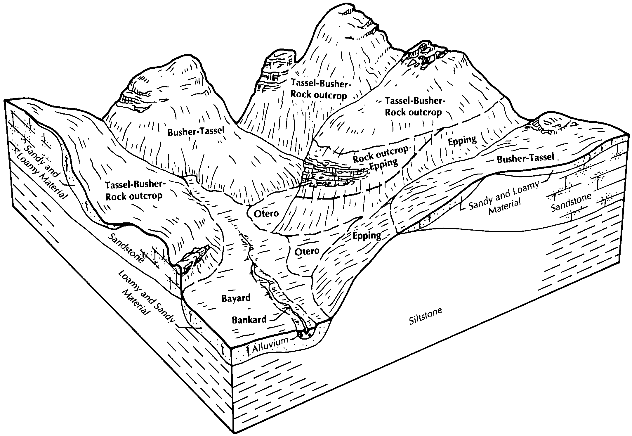
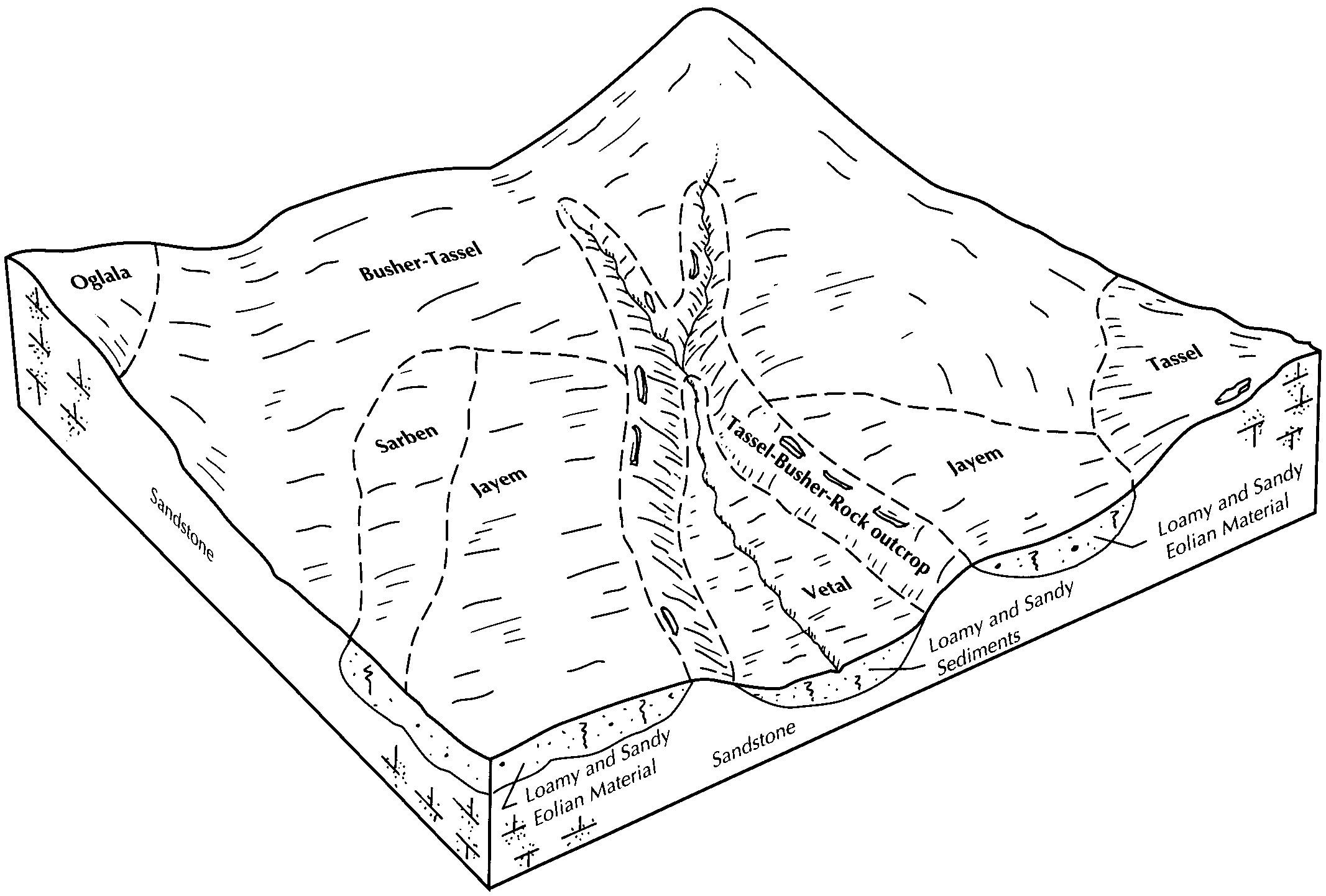
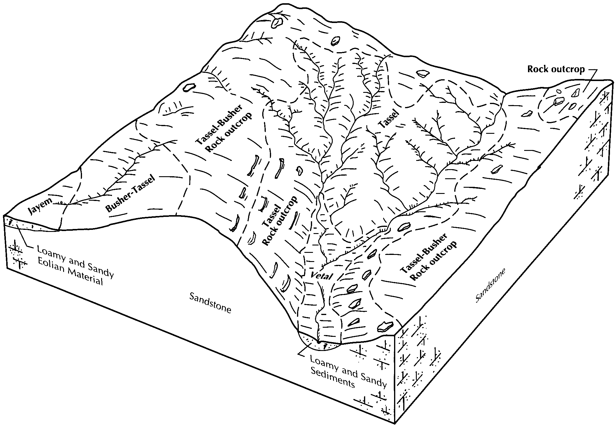
Tassel-Busher-Rock outcrop complex, 20 to 60 percent slopes | 6035 | 27674 | 1692512 | 1tt65 | ne007 | 1988 | 1:20000 |
Tassel-Rock outcrop complex, 20 to 60 percent slopes | 6044 | 14454 | 1692513 | 1tt66 | ne007 | 1988 | 1:20000 |
Busher-Tassel loamy very fine sands, 9 to 20 percent slopes | 5144 | 6831 | 1692469 | 1tt4s | ne007 | 1988 | 1:20000 |
Tassel-Blanche complex, 9 to 30 percent slopes | 6032 | 2889 | 2228149 | 2dsks | ne007 | 1988 | 1:20000 |
Tassel-Blanche sandy loams, 3 to 9 percent slopes | 6041 | 739 | 2228150 | 2dskt | ne007 | 1988 | 1:20000 |
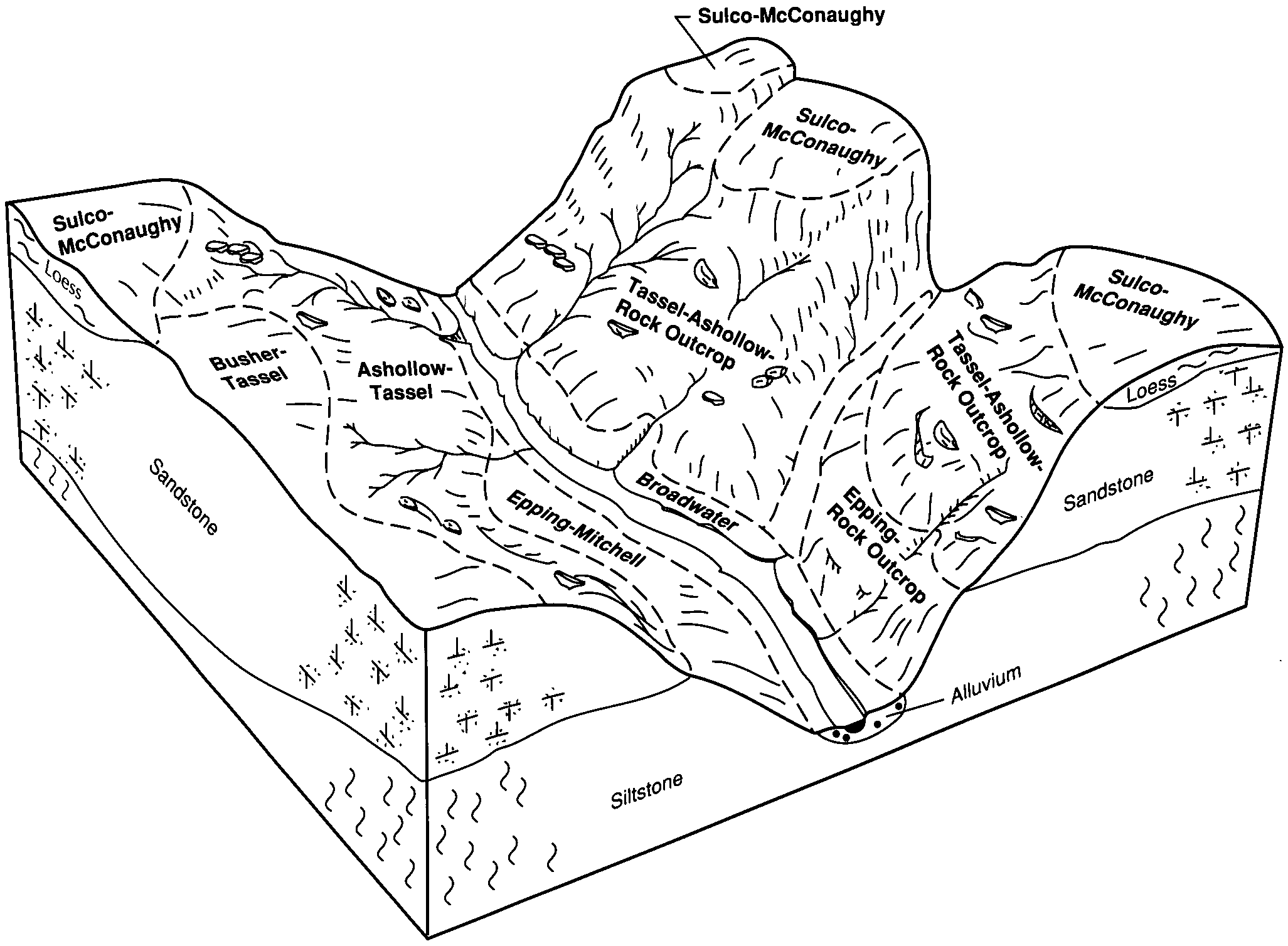
Tassel-Ashollow-Rock outcrop complex, 20 to 60 percent slopes | 6030 | 692 | 2228148 | 2dskr | ne007 | 1988 | 1:20000 |
Tassel-Busher-Rock outcrop complex, 9 to 60 percent slopes | 6034 | 362 | 2228153 | 2dskx | ne007 | 1988 | 1:20000 |
Busher-Tassel complex, 9 to 20 percent slopes | 5140 | 64 | 2228151 | 2dskv | ne007 | 1988 | 1:20000 |
Busher-Tassel loamy very fine sands, 6 to 30 percent slopes | 5143 | 24981 | 357774 | 2tvt6 | ne013 | 1980 | 1:20000 |
Busher-Tassel complex, 0 to 6 percent slopes | 5137 | 6493 | 2217452 | 2wf3h | ne013 | 1980 | 1:20000 |
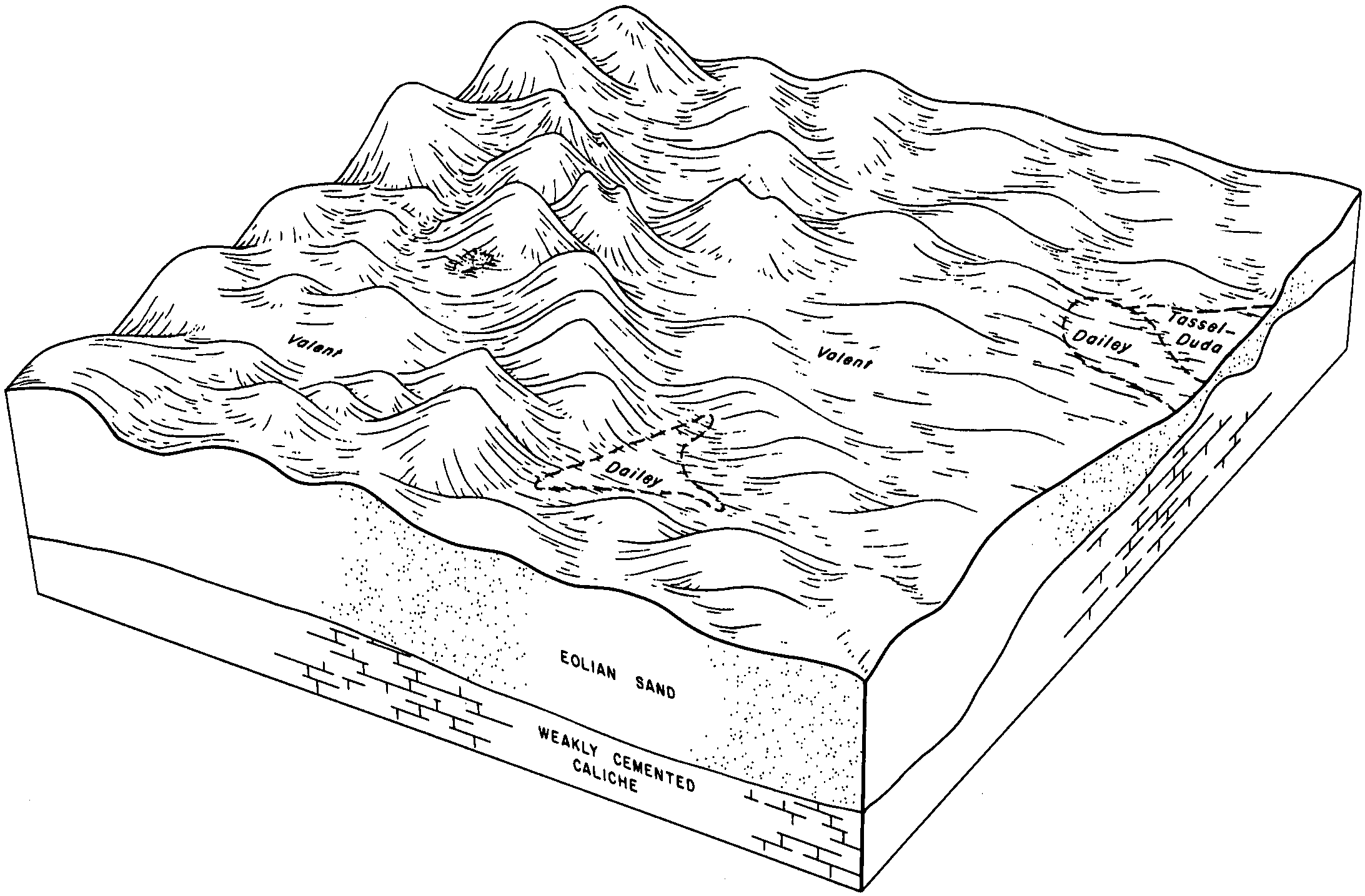
Tassel loamy very fine sand, 3 to 30 percent slopes | 6026 | 4536 | 357830 | d0bx | ne013 | 1980 | 1:20000 |
Busher-Tassel loamy very fine sands, 0 to 6 percent slopes | 5142 | 4066 | 357773 | d092 | ne013 | 1980 | 1:20000 |
Rock outcrop-Tassel complex, 6 to 70 percent slopes | 5983 | 323 | 2217458 | 2wcbj | ne013 | 1980 | 1:20000 |
Tassel-Ashollow-Rock outcrop complex, 9 to 60 percent slopes | 6031 | 124 | 2217461 | 2wcbl | ne013 | 1980 | 1:20000 |
Busher-Tassel loamy very fine sand, 3 to 9 percent slopes | 5145 | 21 | 2217479 | 2dfgl | ne013 | 1980 | 1:20000 |
Tassel-Busher loamy very fine sands, 3 to 30 percent slopes | 6033 | 17 | 2217480 | 2wf44 | ne013 | 1980 | 1:20000 |
Tassel-Busher-Rock outcrop complex, 6 to 30 percent slopes | 6036 | 7 | 2217462 | 2wf45 | ne013 | 1980 | 1:20000 |
Tassel-Duda loamy sands, 0 to 3 percent slopes | 6038 | 5004 | 1699064 | 1v10j | ne029 | 1980 | 1:20000 |
Tassel-Duda loamy sands, 3 to 30 percent slopes | 6039 | 4467 | 1699065 | 1v10k | ne029 | 1980 | 1:20000 |
Duda-Tassel loamy sands, 3 to 6 percent slopes | 4478 | 2755 | 1699023 | 1v0z6 | ne029 | 1980 | 1:20000 |
Duda-Tassel complex, 3 to 6 percent slopes | 4477 | 314 | 2219532 | 2dhlt | ne029 | 1980 | 1:20000 |
Tassel-Duda loamy sands, 6 to 30 percent slopes | 6040 | 240 | 2219533 | 2dhlv | ne029 | 1980 | 1:20000 |
Busher-Tassel fine sandy loams, 9 to 30 percent slopes | 5141 | 2106 | 100356 | 3cf9 | ne031 | 1995 | 1:24000 |
Tassel-Busher complex, 3 to 30 percent slopes | 6022 | 6298 | 1698713 | 1v0n6 | ne033 | 1989 | 1:20000 |
Busher-Tassel complex, 9 to 20 percent slopes | 5140 | 5077 | 1698669 | 1v0ls | ne033 | 1989 | 1:20000 |
Busher-Tassel complex, 3 to 9 percent slopes | 5138 | 4695 | 1698668 | 1v0lr | ne033 | 1989 | 1:20000 |
Tassel-Busher-Rock outcrop complex, 9 to 60 percent slopes | 6034 | 2514 | 1698714 | 1v0n7 | ne033 | 1989 | 1:20000 |
Ashollow-Tassel complex, 9 to 30 percent slopes | 5917 | 1824 | 2219701 | 2wf3w | ne033 | 1989 | 1:20000 |
Tassel-Blanche sandy loams, 3 to 9 percent slopes | 6041 | 1233 | 2219687 | 2dhrt | ne033 | 1989 | 1:20000 |
Tassel-Ashollow-Rock outcrop complex, 20 to 60 percent slopes | 6030 | 896 | 2219685 | 2dhrr | ne033 | 1989 | 1:20000 |
Rock outcrop-Tassel complex, 6 to 70 percent slopes | 5983 | 678 | 1698703 | 2wcbj | ne033 | 1989 | 1:20000 |
Tassel-Blanche complex, 9 to 30 percent slopes | 6032 | 484 | 2219686 | 2dhrs | ne033 | 1989 | 1:20000 |
Altvan-Eckley-Tassel complex, 3 to 9 percent slopes | 1510 | 113 | 2219680 | 2dhrl | ne033 | 1989 | 1:20000 |
Tassel soils, 3 to 30 percent slopes | 6028 | 17105 | 358166 | d0pr | ne045 | 1973 | 1:20000 |
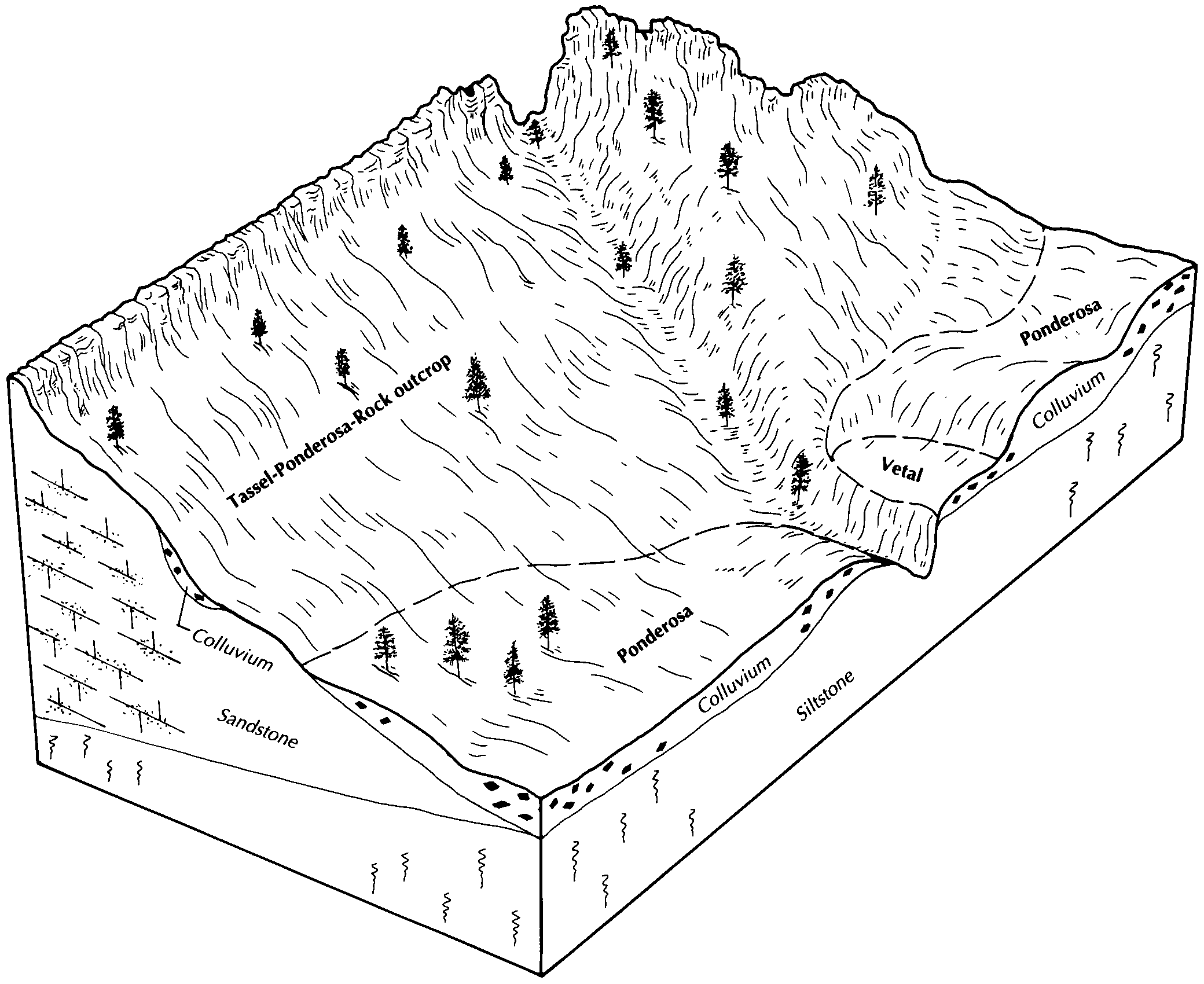
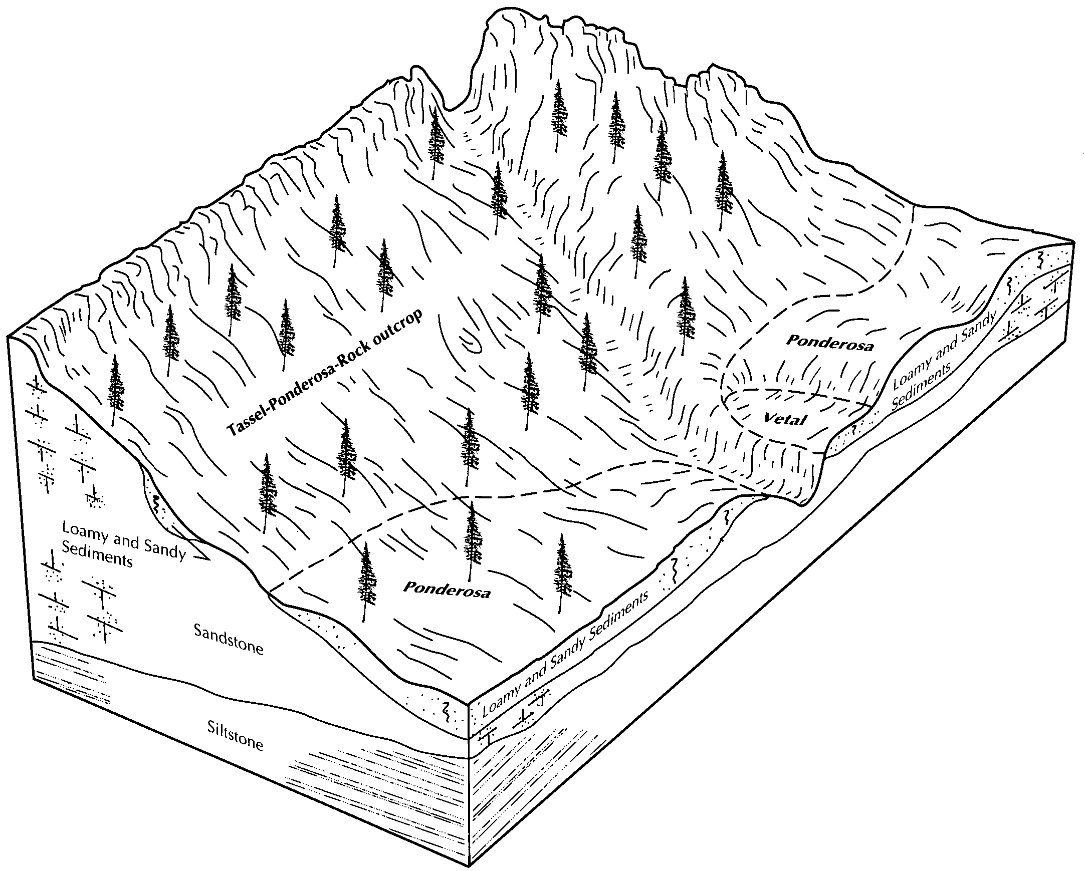
Tassel-Ponderosa-Rock outcrop association, 9 to 70 percent slopes | 6043 | 13095 | 358144 | 2tzzd | ne045 | 1973 | 1:20000 |
Busher-Tassel loamy very fine sands, 6 to 30 percent slopes | 5143 | 12494 | 2217577 | 2tvt6 | ne045 | 1973 | 1:20000 |
Tassel-Ashollow-Rock outcrop complex, 9 to 60 percent slopes | 6031 | 791 | 2217542 | 2wcbl | ne045 | 1973 | 1:20000 |
Ponderosa-Tassel-Vetal complex, 6 to 30 percent slopes | 5234 | 704 | 2217529 | 2wcbh | ne045 | 1973 | 1:20000 |
Rock outcrop-Tassel complex, 6 to 70 percent slopes | 5983 | 661 | 2217540 | 2wcbj | ne045 | 1973 | 1:20000 |
Tassel-Busher-Rock outcrop complex, 6 to 30 percent slopes | 6036 | 313 | 2217543 | 2wf45 | ne045 | 1973 | 1:20000 |
Tassel-Rock outcrop complex, 9 to 70 percent slopes | 6045 | 99 | 2217568 | 2wcbk | ne045 | 1973 | 1:20000 |
Tassel loamy very fine sand, 3 to 30 percent slopes | 6026 | 88 | 2217581 | 2dfkw | ne045 | 1973 | 1:20000 |
Ashollow-Tassel complex, 9 to 30 percent slopes | 5917 | 3206 | 1698796 | 2wf3w | ne049 | 2000 | 1:24000 |
Tassel-Ashollow-Rock outcrop complex, 9 to 60 percent slopes | 6031 | 1331 | 1699111 | 1v121 | ne057 | 1995 | 1:24000 |
Ashollow-Tassel complex, 9 to 30 percent slopes | 5917 | 29794 | 1698723 | 2wf3w | ne069 | 1995 | 1:20000 |
Tassel-Ashollow-Rock outcrop complex, 20 to 60 percent slopes | 6030 | 21176 | 1698779 | 1v0qb | ne069 | 1995 | 1:20000 |
Busher-Tassel complex, 9 to 20 percent slopes | 5140 | 1535 | 1698733 | 1v0nv | ne069 | 1995 | 1:20000 |
Busher-Tassel complex, 3 to 9 percent slopes | 5138 | 1349 | 1698732 | 1v0nt | ne069 | 1995 | 1:20000 |
Tassel-Busher-Rock outcrop complex, 9 to 60 percent slopes | 6034 | 40 | 2219223 | 2dh8v | ne069 | 1995 | 1:20000 |
Tassel-Otero-Rock outcrop complex, 15 to 60 percent slopes | 6042 | 9480 | 1698920 | 1v0vw | ne101 | 1990 | 1:20000 |
Valent-Tassel-Rock Outcrop complex, 9 to 60 percent slopes | 4885 | 3806 | 1698926 | 2yvr9 | ne101 | 1990 | 1:20000 |
Tassel-Ashollow-Rock outcrop complex, 20 to 60 percent slopes | 6030 | 284 | 2219591 | 2dhnq | ne101 | 1990 | 1:20000 |
Tassel-Blanche sandy loams, 3 to 9 percent slopes | 6041 | 122048 | 1692557 | 1tt7m | ne105 | 2004 | 1:24000 |
Tassel-Blanche complex, 9 to 30 percent slopes | 6032 | 64190 | 1692558 | 1tt7n | ne105 | 2004 | 1:24000 |
Altvan-Eckley-Tassel complex, 3 to 9 percent slopes | 1510 | 14776 | 1692534 | 1tt6w | ne105 | 2004 | 1:24000 |
Tassel and Dix and Altvan soils, 9 to 30 percent slopes | 6023 | 10234 | 1692559 | 1tt7p | ne105 | 2004 | 1:24000 |
Tassel-Ashollow-Rock outcrop complex, 20 to 60 percent slopes | 6030 | 9248 | 1692556 | 1tt7l | ne105 | 2004 | 1:24000 |
Rosebud-Tassel sandy loams, 0 to 3 percent slopes | 1745 | 8283 | 1692555 | 1tt7k | ne105 | 2004 | 1:24000 |
Tassel-Busher loamy very fine sands, 3 to 30 percent slopes | 6033 | 42813 | 1692658 | 2wf44 | ne123 | 1981 | 1:20000 |
Rock outcrop-Tassel complex, 6 to 70 percent slopes | 5983 | 22221 | 1692652 | 2wcbj | ne123 | 1981 | 1:20000 |
Tassel loamy very fine sand, 20 to 50 percent slopes | 6025 | 20440 | 1692657 | 1ttbv | ne123 | 1981 | 1:20000 |
Busher-Tassel loamy very fine sands, 9 to 20 percent slopes | 5144 | 11615 | 1692594 | 1tt8t | ne123 | 1981 | 1:20000 |
Busher-Tassel loamy very fine sand, 3 to 9 percent slopes | 5145 | 7811 | 1692593 | 1tt8s | ne123 | 1981 | 1:20000 |
Tassel-Busher complex, 3 to 30 percent slopes | 6022 | 4843 | 2220389 | 2wf43 | ne123 | 1981 | 1:20000 |
Tassel-Busher-Rock outcrop complex, 9 to 60 percent slopes | 6034 | 3505 | 1692659 | 1ttbx | ne123 | 1981 | 1:20000 |
Tassel-Rock outcrop complex, 20 to 60 percent slopes | 6044 | 1281 | 2220383 | 2djh8 | ne123 | 1981 | 1:20000 |
Tassel-Busher-Rock outcrop complex, 20 to 60 percent slopes | 6035 | 686 | 2220382 | 2djh7 | ne123 | 1981 | 1:20000 |
Busher-Tassel complex, 3 to 9 percent slopes | 5138 | 675 | 2220362 | 2djgl | ne123 | 1981 | 1:20000 |
Busher-Tassel complex, 9 to 20 percent slopes | 5140 | 566 | 2220363 | 2djgm | ne123 | 1981 | 1:20000 |
Ashollow-Tassel complex, 9 to 30 percent slopes | 5917 | 298 | 2220368 | 2wf3w | ne123 | 1981 | 1:20000 |
Tassel-Ashollow-Rock outcrop complex, 20 to 60 percent slopes | 6030 | 40 | 2220370 | 2djgv | ne123 | 1981 | 1:20000 |
Duda-Tassel complex, 3 to 6 percent slopes | 4477 | 670 | 1698964 | 1v0x9 | ne135 | 1987 | 1:20000 |
Tassel-Duda loamy sands, 6 to 30 percent slopes | 6040 | 411 | 1698993 | 1v0y7 | ne135 | 1987 | 1:20000 |
Tassel soils, 20 to 50 percent slopes | 6027 | 14257 | 1653791 | 1shx3 | ne157 | 1965 | 1:20000 |
Tassel-Busher complex, 3 to 30 percent slopes | 6022 | 7281 | 1653790 | 2wf43 | ne157 | 1965 | 1:20000 |
Rock outcrop-Tassel complex, 6 to 70 percent slopes | 5983 | 4252 | 1653784 | 2wcbj | ne157 | 1965 | 1:20000 |
Tassel-Ashollow-Rock outcrop complex, 9 to 60 percent slopes | 6031 | 3056 | 2227678 | 2wcbl | ne157 | 1965 | 1:20000 |
Tassel-Busher-Rock outcrop complex, 20 to 60 percent slopes | 6035 | 2944 | 2227655 | 2ds1v | ne157 | 1965 | 1:20000 |
Tassel-Busher loamy very fine sands, 3 to 30 percent slopes | 6033 | 1464 | 2227696 | 2wf44 | ne157 | 1965 | 1:20000 |
Busher-Tassel loamy very fine sands, 9 to 20 percent slopes | 5144 | 736 | 2227647 | 2ds1l | ne157 | 1965 | 1:20000 |
Tassel loamy very fine sand, 20 to 50 percent slopes | 6025 | 440 | 2227695 | 2ds34 | ne157 | 1965 | 1:20000 |
Busher-Tassel loamy very fine sands, 6 to 30 percent slopes | 5143 | 259 | 2227700 | 2tvt6 | ne157 | 1965 | 1:20000 |
Tassel-Rock outcrop complex, 20 to 60 percent slopes | 6044 | 232 | 2227656 | 2ds1w | ne157 | 1965 | 1:20000 |
Busher-Tassel complex, 0 to 6 percent slopes | 5137 | 31 | 2227662 | 2wf3h | ne157 | 1965 | 1:20000 |
Tassel-Ponderosa-Rock outcrop association, 9 to 70 percent slopes | 6043 | 70961 | 100638 | 2tzzd | ne161 | 1992 | 1:20000 |
Ponderosa-Tassel-Vetal complex, 6 to 30 percent slopes | 5234 | 43179 | 100630 | 2wcbh | ne161 | 1992 | 1:20000 |
Tassel-Rock outcrop complex, 9 to 70 percent slopes | 6045 | 11062 | 100637 | 2wcbk | ne161 | 1992 | 1:20000 |
Busher-Tassel complex, 6 to 30 percent slopes | 5139 | 10006 | 100574 | 2wf3j | ne161 | 1992 | 1:20000 |
Busher-Tassel complex, 0 to 6 percent slopes | 5137 | 3767 | 100573 | 2wf3h | ne161 | 1992 | 1:20000 |
Busher-Tassel fine sandy loams, 9 to 30 percent slopes | 5141 | 140 | 2219847 | 2dhxz | ne161 | 1992 | 1:20000 |
Busher-Tassel loamy very fine sands, 6 to 30 percent slopes | 5143 | 128277 | 357894 | 2tvt6 | ne165 | 1993 | 1:20000 |
Tassel-Ponderosa-Rock outcrop association, 9 to 70 percent slopes | 6043 | 82660 | 358040 | 2tzzd | ne165 | 1993 | 1:20000 |
Tassel-Ashollow-Rock outcrop complex, 9 to 60 percent slopes | 6031 | 71861 | 358038 | 2wcbl | ne165 | 1993 | 1:20000 |
Tassel-Busher-Rock outcrop complex, 6 to 30 percent slopes | 6036 | 43772 | 358039 | 2wf45 | ne165 | 1993 | 1:20000 |
Busher-Tassel complex, 0 to 6 percent slopes | 5137 | 32035 | 357893 | 2wf3h | ne165 | 1993 | 1:20000 |
Ponderosa-Tassel-Vetal complex, 6 to 30 percent slopes | 5234 | 26170 | 357998 | 2wcbh | ne165 | 1993 | 1:20000 |
Rock outcrop-Tassel complex, 6 to 70 percent slopes | 5983 | 15691 | 357999 | 2wcbj | ne165 | 1993 | 1:20000 |
Phiferson-Tassel-Rock outcrop complex, 6 to 30 percent slopes | 5985 | 1174 | 357990 | 2t34t | ne165 | 1993 | 1:20000 |
Valentine-Tassel complex, hilly | VeD | 12324 | 352766 | cv2k | sd007 | 2004 | 1:20000 |
Anselmo-Tassel fine sandy loams, 9 to 18 percent slopes | AtE | 10965 | 352721 | cv13 | sd007 | 2004 | 1:20000 |
Tassel-Anselmo fine sandy loams, 18 to 40 percent slopes | TaF | 4242 | 352761 | cv2d | sd007 | 2004 | 1:20000 |
Anselmo-Tassel fine sandy loams, 6 to 25 percent slopes | AtE | 25797 | 355224 | cxmv | sd053 | 1982 | 1:20000 |
Tassel-Rock outcrop complex, 9 to 30 percent slopes | TrE | 1533 | 355295 | cxq4 | sd053 | 1982 | 1:20000 |
Ree-Tassel complex, 3 to 9 percent slopes | RcC | 1437 | 355284 | cxps | sd053 | 1982 | 1:20000 |
Valentine-Tassel complex, 5 to 30 percent slopes | VsE | 17922 | 353048 | cvcn | sd121 | 1967 | 1:31680 |
Busher-Tassel complex, 6 to 30 percent slopes | T184F | 660 | 2582803 | 2wf3j | sd613 | 2011 | 1:24000 |
Tassel-Anselmo complex, 10 to 40 percent slopes | TaF | 380 | 2582736 | cv4l | sd613 | 2011 | 1:24000 |
Tassel-Rock outcrop complex, 9 to 70 percent slopes | T179G | 358 | 2582802 | 2wcbk | sd613 | 2011 | 1:24000 |
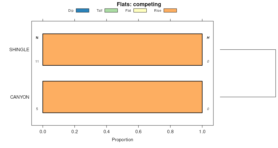
Tassel-Shingle complex, 10 to 30 percent slopes | 180 | 19921 | 349265 | cqfm | wy011 | 1978 | 1:24000 |
Ascalon-Tassel complex, 3 to 10 percent slopes | 18 | 1893 | 349264 | cqfl | wy011 | 1978 | 1:24000 |
Phiferson-Tassel-Rock outcrop complex, 6 to 30 percent slopes | 173 | 36855 | 349659 | 2t34t | wy027 | 1993 | 1:24000 |
Rock outcrop-Tassel complex, 6 to 70 percent slopes | 182 | 13288 | 349677 | 2wcbj | wy027 | 1993 | 1:24000 |
Tassel-Trelona-Phiferson fine sandy loams, 3 to 10 percent slopes | 200 | 10277 | 349711 | cqx0 | wy027 | 1993 | 1:24000 |
Tassel-Ponderosa-Rock outcrop association, 9 to 70 percent slopes | 199 | 355 | 349710 | 2tzzd | wy027 | 1993 | 1:24000 |
Tassel-Turnercrest fine sandy loams, 6 to 30 percent slopes | 111 | 84068 | 349395 | 2v09b | wy045 | 1984 | 1:24000 |
Shingle-Tassel complex, 2 to 30 percent slopes | 109 | 75655 | 3019880 | 2wxyx | wy045 | 1984 | 1:24000 |
Worf-Shingle-Tassel complex, 3 to 30 percent slopes | 128 | 12980 | 349413 | cqld | wy045 | 1984 | 1:24000 |
Tassel-Terro-Rock outcrop complex, 15 to 30 percent slopes | 110 | 9806 | 349394 | 2v098 | wy045 | 1984 | 1:24000 |
Bowbac-Tassel-Rock outcrop complex, 3 to 20 percent slopes | 7 | 3828 | 349476 | cqnf | wy045 | 1984 | 1:24000 |
Rock outcrop-Tassel-Pultney complex, 5 to 40 percent slopes | 489 | 8734 | 152235 | 53dt | wy603 | | 1:24000 |
Rock outcrop-Tassel complex, 6 to 70 percent slopes | 109 | 2044 | 1669816 | 2wcbj | wy609 | 2006 | 1:24000 |
Worf-Shingle-Tassel complex, 3 to 30 percent slopes | 270 | 1605 | 1669800 | 2wxz3 | wy609 | 2006 | 1:24000 |
Tassel-Tullock-Vonalee complex, 6 to 30 percent slopes | 246 | 561 | 1669783 | 2wxyv | wy609 | 2006 | 1:24000 |
Shingle-Tassel complex, 2 to 30 percent slopes | 245 | 251 | 1669782 | 2wxyx | wy609 | 2006 | 1:24000 |
Rock land | Rc | 43247 | 104733 | 3hzh | wy615 | 1965 | 1:20000 |
Rock outcrop-Tassel complex | Rd | 12053 | 104734 | 3hzj | wy615 | 1965 | 1:20000 |
Colby-Tassel complex, 2 to 8 percent slopes | CtC | 3890 | 104678 | 3hxq | wy615 | 1965 | 1:20000 |
Shingle-Tassel complex, 2 to 30 percent slopes | 135 | 72780 | 816859 | 2wxyx | wy619 | 1971 | 1:24000 |
Terro-Tassel-Shingle complex, 6 to 40 percent slopes | TE | 19758 | 350951 | 2yv76 | wy619 | 1971 | 1:24000 |
Valent-Cushman association | VC | 8417 | 350960 | cs69 | wy619 | 1971 | 1:24000 |
Pugsley-Southfork complex hilly | PXD | 2280 | 350908 | cs4m | wy619 | 1971 | 1:24000 |
Worf-Shingle-Tassel complex, 3 to 30 percent slopes | 149 | 130 | 816860 | 2wxz3 | wy619 | 1971 | 1:24000 |
Tassel-Otero-Rock outcrop complex, 10 to 30 percent slopes | 37 | 16410 | 104834 | 3j2r | wy621 | 1980 | 1:24000 |
Tassel thin solum-Tassel-Rock outcrop complex, 10 to 30 percent slopes | 38 | 13588 | 104827 | 3j2j | wy621 | 1980 | 1:24000 |
Mitchell variant-Tassel variant fine sandy loams, 0 to 3 percent slopes | 28 | 422 | 104817 | 3j26 | wy621 | 1980 | 1:24000 |
Worf-Shingle-Tassel complex, 3 to 30 percent slopes | 320 | 585 | 1421357 | 2wxz3 | wy625 | 1985 | 1:24000 |
Shingle-Tassel complex, 2 to 30 percent slopes | 326 | 160 | 1426084 | 2wxyx | wy625 | 1985 | 1:24000 |
Tassel-Tullock-Vonalee complex, 6 to 30 percent slopes | 325 | 148 | 1426083 | 2wxyv | wy625 | 1985 | 1:24000 |
Keeline-Tassel-Turnback complex, 6 to 15 percent slopes | 323 | 135 | 1421360 | 2yry5 | wy625 | 1985 | 1:24000 |
Olney-Chugcity-Tassel complex, 1 to 4 percent slopes | 5230 | 385 | 3206665 | 2zc5q | wy629 | | 1:24000 |
Tassel-Bowbac-Terro complex, 3 to 30 percent slopes -- Draft | 398 | 159 | 152545 | 53qt | wy629 | | 1:24000 |
Worf-Shingle-Tassel complex, 3 to 30 percent slopes | 149 | 125455 | 351527 | 2wxz3 | wy709 | 1983 | 1:24000 |
Tassel-Tullock-Vonalee complex, 6 to 30 percent slopes | 137 | 72041 | 351515 | 2wxyv | wy709 | 1983 | 1:24000 |
Shingle-Tassel complex, 2 to 30 percent slopes | 135 | 33590 | 351513 | 2wxyx | wy709 | 1983 | 1:24000 |
Tassel-Terro-Rock outcrop complex, 15 to 30 percent slopes | 136 | 21942 | 351514 | 2v098 | wy709 | 1983 | 1:24000 |
Keeline-Tassel-Turnback complex, 6 to 15 percent slopes | 123 | 19672 | 351501 | 2yry5 | wy709 | 1983 | 1:24000 |
Shingle, thin solum-Rock outcrop-Tassel,thin solum complex, cool, 6 to 45 percent slopes | 132 | 5282 | 351510 | css1 | wy709 | 1983 | 1:24000 |
Rock outcrop-Tassel complex, 6 to 70 percent slopes | 22 | 43425 | 104867 | 2wcbj | wy715 | 1974 | 1:20000 |
Dwyer-Valent-Tassel complex, 3 to 20 percent slopes | 8D | 29746 | 104898 | 3j4t | wy715 | 1974 | 1:20000 |
Busher-Tassel loamy very fine sands, 6 to 30 percent slopes | 74 | 399 | 1415360 | 2tvt6 | wy715 | 1974 | 1:20000 |
Busher-Tassel complex, 0 to 6 percent slopes | 72 | 129 | 1415358 | 2wf3h | wy715 | 1974 | 1:20000 |
Tassel-Ashollow-Rock outcrop complex, 9 to 60 percent slopes | 85 | 95 | 1415371 | 2wcbl | wy715 | 1974 | 1:20000 |
Otero-Valent-Tassel complex, 0 to 15 percent slopes | 151 | 11425 | 104952 | 3j6k | wy721 | 1994 | 1:24000 |