Oregon Basin-Vonalee-Hiland complex, 1 to 8 percent slopes
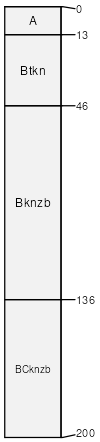
Oregon Basin
(40%)
Saline Lowland Drained (SLDr) Big Horn Basin Wet
Ustic Natrargids
Well drained
Hydric: No
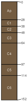
PAWS: 29 cm
stream terraces
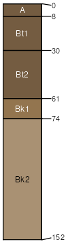
Vonalee
(25%)
Overflow (Ov) Big Horn Basin Wet
Ustic Haplargids
Well drained
Hydric: No
PAWS: 17 cm
stream terraces
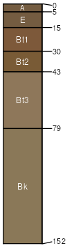
Hiland
(20%)
Loamy (Ly) Big Horn Basin Rim
Ustic Haplargids
Well drained
Hydric: No
PAWS: 36 cm
stream terraces
Keeline
(10%)
Sandy (Sy) Big Horn Basin Rim
Ustic Torriorthents
Well drained
Hydric: No
PAWS: 22 cm
stream terraces
Green River
(5%)
Overflow (Ov) Big Horn Basin Wet
Oxyaquic Torrifluvents
Moderately well drained
Hydric: No
PAWS: 15 cm
flood plains
SSA
Scale
Published
Export
wy629
1:24,000
2025-09-04