Scooby-Obadia-Poposhia complex, 1 to 6 percent slopes
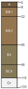
Scooby
(40%)
Saline Upland Green River and Great Divide Basins (SU)
Sodic Ustic Haplocambids
Well drained
Hydric: No
PAWS: 26 cm
alluvial fans
Obadia
(25%)
Saline Upland Green River and Great Divide Basins (SU)
Ustic Natrargids
Well drained
Hydric: No
PAWS: 36 cm
alluvial fans
Poposhia
(20%)
Loamy Green River Basin (Ly GRB)
Ustic Haplocambids
Well drained
Hydric: No
PAWS: 34 cm
alluvial fans
Colnevee
(5%)
Saline Upland Green River and Great Divide Basins (SU)
Ustic Torriorthents
Well drained
Hydric: No
PAWS: 34 cm
alluvial fans
Alldown family
(5%)
Overflow Foothills and Basins West (Ov)
Ustic Haplocambids
Well drained
Hydric: No
PAWS: 36 cm
alluvial fans
Sweetlette
(5%)
Saline Upland Green River and Great Divide Basins (SU)
Ustic Haplargids
Well drained
Hydric: No
PAWS: 18 cm
hillslopes / Footslope
SSA
Scale
Published
Export
wy737
1:24,000
2025-09-04