| Bankard sand, 0 to 1 percent slopes, moist, frequently flooded | Bk | 28770 | 94179 | 2w4ph | co009 | 1966 | 1:20000 |
Bankard soils | Bd | 11619 | 94234 | 351t | co011 | 1965 | 1:15840 |
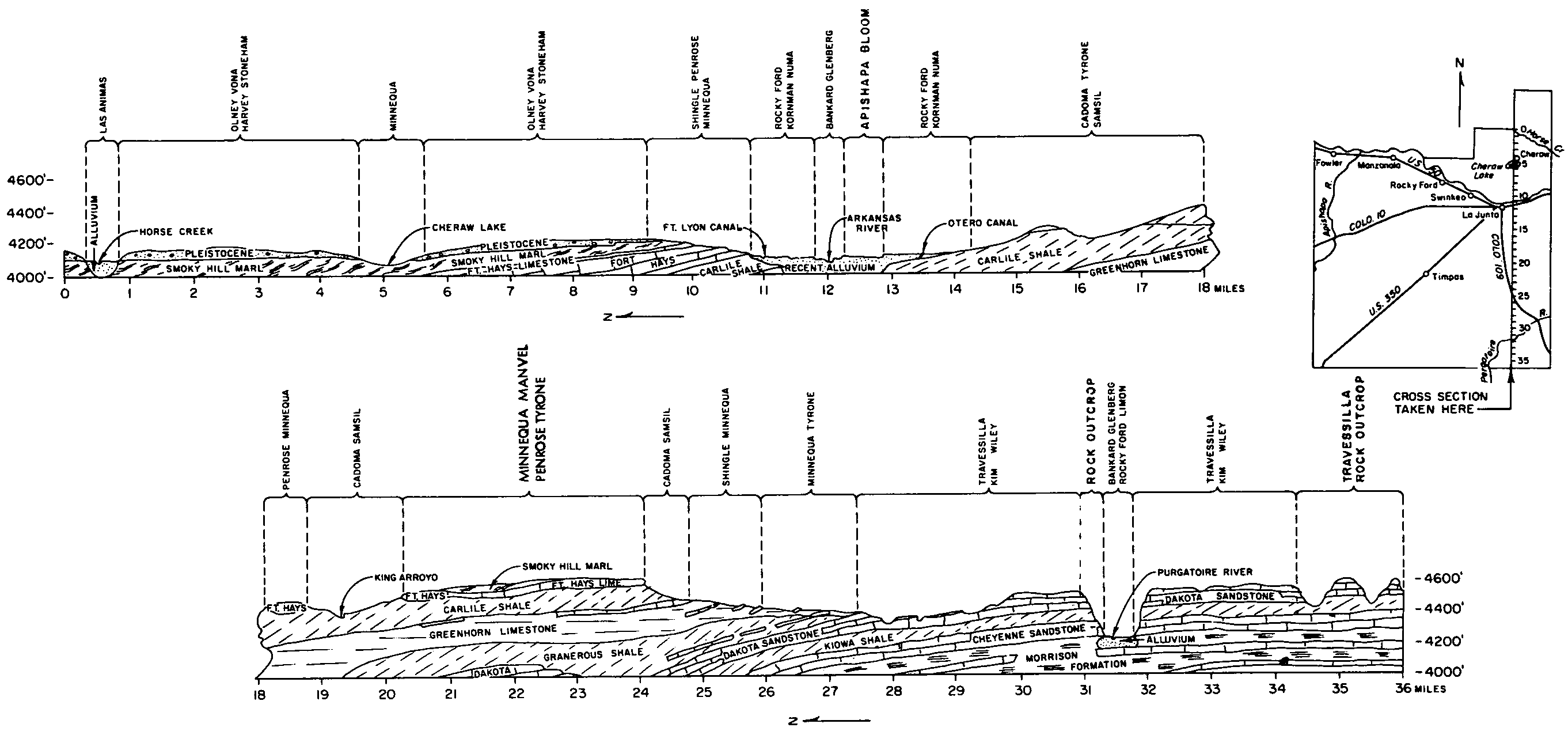
Bankard-Glenberg complex, 0 to 3 percent slopes, moist, occasionally flooded | 15 | 21839 | 94302 | 2w4pg | co017 | 1985 | 1:24000 |
Bankard and Glenberg soils | Bg | 4323 | 94356 | 355r | co025 | 1965 | 1:15840 |
Bankard soils | Bd | 1633 | 94355 | 355q | co025 | 1965 | 1:15840 |
Bankard-Glenberg complex, 0 to 2 percent slopes, occasionally flooded | 5 | 5347 | 94453 | 2rgs0 | co061 | 1977 | 1:24000 |
Glenberg, rarely flooded-Bankard, occasionally flooded, complex, 0 to 3 percent slopes | 25 | 25930 | 96820 | 37r7 | co063 | 1996 | 1:24000 |
Bankard-Glenberg complex, 0 to 3 percent slopes, moist, occasionally flooded | 112 | 34194 | 105193 | 2w4pg | co073 | 2001 | 1:24000 |
Bankard-Glenberg complex, 0 to 2 percent slopes, occasionally flooded | 223 | 9654 | 2933369 | 2rgs0 | co073 | 2001 | 1:24000 |
Bankard soils, 0 to 2 percent slopes, occasionally flooded | Bk | 4880 | 2611176 | 2rgrz | co089 | 1966 | 1:15840 |
Bankard-Glenberg complex, 0 to 2 percent slopes, occasionally flooded | BG | 1766 | 2611178 | 2rgs0 | co089 | 1966 | 1:15840 |
Bankard sand | 6 | 13830 | 95094 | 35yk | co125 | 1976 | 1:24000 |
Glenberg-Bankard complex | 16 | 2066 | 95058 | 35xd | co125 | 1976 | 1:24000 |
Bankard sand, 0 to 2 percent slopes, frequently flooded | Bk | 6201 | 95483 | 2w4pd | co626 | 1974 | 1:24000 |
Bankard family-Cameo complex, 0 to 5 percent slopes | 227 | 114 | 628883 | p3dk | co686 | 1992 | 1:31680 |
Bankard family-Cameo complex, 0 to 5 percent slopes | 5 | 437 | 506287 | jztv | co692 | 1998 | 1:24000 |
Tsetaa family-Bankard family-Fluvaquents complex, 0 to 45 percent slopes, very stony | 65 | 282 | 506297 | jzv5 | co692 | 1998 | 1:24000 |
Bankard sand, occasionally flooded | 1119 | 9204 | 1149545 | 17l63 | ks023 | 1987 | 1:24000 |
Bankard loamy fine sand, occasionally flooded | 1114 | 1363 | 1149544 | 17l62 | ks023 | 1987 | 1:24000 |
Bankard loamy sand, occasionally flooded | 1118 | 39 | 1150500 | 17m5x | ks109 | 1962 | 1:24000 |
Bankard sandy loam, rarely flooded | 1318 | 13 | 1150501 | 17m5y | ks109 | 1962 | 1:24000 |
Bankard loamy sand, occasionally flooded | 1118 | 7595 | 1150182 | 17lvn | ks199 | 1984 | 1:24000 |
Bankard sandy loam, rarely flooded | 1318 | 5301 | 1150183 | 17lvp | ks199 | 1984 | 1:24000 |
Glenberg-Bankard complex, 0 to 3 percent slopes | 1166 | 192 | 1150195 | 17lw2 | ks199 | 1984 | 1:24000 |
Bankard fine sandy loam | Ba | 10950 | 347834 | cnyg | mt643 | 1967 | 1:20000 |
Bankard fine sand, channeled, frequently flooded | 1001 | 4610 | 1692457 | 2wf3v | ne007 | 1988 | 1:20000 |
Bankard loamy fine sand, occasionally flooded | 1114 | 2376 | 1692456 | 1tt4c | ne007 | 1988 | 1:20000 |
Bankard very fine sandy loam, 0 to 3 percent slopes | 1012 | 689 | 357766 | d08v | ne013 | 1980 | 1:20000 |
Bankard fine sand, channeled, frequently flooded | 1001 | 195 | 357765 | 2wf3v | ne013 | 1980 | 1:20000 |
Bankard loamy fine sand, channeled, 0 to 2 percent slopes, frequently flooded | 1006 | 134 | 2217447 | 2wcbb | ne013 | 1980 | 1:20000 |
Bankard loamy coarse sand, frequently flooded | 1013 | 4 | 2217481 | 2dfgn | ne013 | 1980 | 1:20000 |
Bankard loamy fine sand, channeled, frequently flooded | 1006 | 7952 | 1698657 | 1v0ld | ne033 | 1989 | 1:20000 |
Bankard loamy sand, occasionally flooded | 1118 | 6236 | 1698656 | 1v0lc | ne033 | 1989 | 1:20000 |
Bankard loamy fine sand, frequently flooded | 1014 | 5394 | 358160 | d0pk | ne045 | 1973 | 1:20000 |
Bankard loamy fine sand, 0 to 2 percent slopes | 1004 | 3645 | 358071 | d0lp | ne045 | 1973 | 1:20000 |
Bankard loamy fine sand, wet variant | 1008 | 2494 | 358072 | d0lq | ne045 | 1973 | 1:20000 |
Bankard loamy coarse sand, frequently flooded | 1013 | 1993 | 358105 | d0ms | ne045 | 1973 | 1:20000 |
Bankard loamy fine sand, occasionally flooded | 1114 | 495 | 2217507 | 2dfhh | ne045 | 1973 | 1:20000 |
Bankard loamy fine sand, channeled, 0 to 2 percent slopes, frequently flooded | 1006 | 255 | 2217504 | 2wcbb | ne045 | 1973 | 1:20000 |
Bankard very fine sandy loam, 0 to 3 percent slopes | 1012 | 122 | 2217570 | 2dfkj | ne045 | 1973 | 1:20000 |
Bankard fine sand, channeled, frequently flooded | 1001 | 20 | 2217569 | 2wf3v | ne045 | 1973 | 1:20000 |
Bankard sand, occasionally flooded | 1119 | 252 | 1699077 | 1v10y | ne057 | 1995 | 1:24000 |
Bankard loamy coarse sand, occasionally flooded | 1002 | 4 | 2219216 | 2dh8m | ne069 | 1995 | 1:20000 |
Bankard loamy sand, occasionally flooded | 1118 | 100 | 1699232 | 1v15y | ne085 | 1981 | 1:20000 |
Bankard loamy fine sand, rarely flooded | 1003 | 1066 | 1699285 | 1v17n | ne087 | 1965 | 1:20000 |
Bankard loamy sand, channeled, frequently flooded | 1010 | 3639 | 1698873 | 1v0tc | ne101 | 1990 | 1:20000 |
Bankard loamy sand, rarely flooded | 1009 | 1551 | 1698872 | 1v0tb | ne101 | 1990 | 1:20000 |
Bankard sand, rarely flooded | 1011 | 1268 | 1698871 | 1v0t9 | ne101 | 1990 | 1:20000 |
Bankard loamy fine sand, loamy subsoil variant | 1007 | 1745 | 1699144 | 1v133 | ne111 | 1971 | 1:24000 |
Bankard fine sand, channeled, frequently flooded | 1001 | 13877 | 1692580 | 2wf3v | ne123 | 1981 | 1:20000 |
Bankard loamy fine sand, occasionally flooded | 1114 | 3965 | 1692579 | 1tt8b | ne123 | 1981 | 1:20000 |
Bankard loamy fine sand, channeled, frequently flooded | 1006 | 1549 | 2220373 | 2djgy | ne123 | 1981 | 1:20000 |
Bankard loamy coarse sand, occasionally flooded | 1002 | 1415 | 1692578 | 1tt89 | ne123 | 1981 | 1:20000 |
Bankard loamy sand, channeled, frequently flooded | 1010 | 67 | 1698957 | 1v0x2 | ne135 | 1987 | 1:20000 |
Bankard loamy fine sand, wet variant | 1008 | 878 | 1653706 | 1shtc | ne157 | 1965 | 1:20000 |
Bankard fine sand, channeled, frequently flooded | 1001 | 320 | 1653788 | 2wf3v | ne157 | 1965 | 1:20000 |
Bankard loamy fine sand, 0 to 2 percent slopes | 1004 | 199 | 1653717 | 1shtq | ne157 | 1965 | 1:20000 |
Bankard loamy fine sand, occasionally flooded | 1114 | 23 | 2227635 | 2ds16 | ne157 | 1965 | 1:20000 |
Bankard loamy fine sand, channeled, 0 to 2 percent slopes, frequently flooded | 1006 | 406 | 100561 | 2wcbb | ne161 | 1992 | 1:20000 |
Bankard loamy fine sand, channeled, 0 to 2 percent slopes, frequently flooded | 1006 | 2464 | 357859 | 2wcbb | ne165 | 1993 | 1:20000 |
Bankard loamy fine sand, occasionally flooded | 1114 | 1448 | 357858 | d0ct | ne165 | 1993 | 1:20000 |
Bankard loamy sand | Bk | 1499 | 3031438 | dmtn | nm059 | 1972 | 1:24000 |
Bankard loamy fine sand, 0 to 3 percent slopes | T020A | 890 | 1390014 | 1hnf5 | sd007 | 2004 | 1:20000 |
Bankard fine sandy loam | Bb | 6862 | 355090 | cxhj | sd047 | 1980 | 1:24000 |
Bankard loamy sand, hummocky | Bc | 1802 | 354072 | cwfp | sd055 | 1992 | 1:24000 |
Bankard very fine sandy loam | Bd | 1626 | 354073 | cwfq | sd055 | 1992 | 1:24000 |
Bankard loamy fine sand, 0 to 3 percent slopes | T020A | 340 | 1391537 | 1hq09 | sd121 | 1967 | 1:31680 |
Bankard Loamy Fine Sand, 0 to 3 percent slopes, occasionally flooded | Bk | 2802 | 355825 | 2zk48 | sd137 | 1985 | 1:24000 |
Bankard loamy fine sand, gravelly substratum, 0 to 3 percent slopes, frequently flooded | Bn | 555 | 355826 | 2zk47 | sd137 | 1985 | 1:24000 |
Bankard soils | Ba | 6962 | 354303 | cwp4 | sd600 | 1974 | 1:24000 |
Bankard Loamy Fine Sand, 0 to 3 percent slopes, occasionally flooded | Bk | 769 | 355421 | 2zk48 | sd601 | 1983 | 1:24000 |
Bankard gravelly loamy sand | Bb | 642 | 355422 | cxv7 | sd601 | 1983 | 1:24000 |
Bankard loamy fine sand, 0 to 4 percent slopes | BcB | 11218 | 2580869 | cyg3 | sd606 | 2011 | 1:24000 |
Craft-Bankard variant very fine sandy loams | Cv | 2193 | 2581011 | cy28 | sd611 | 2011 | 1:24000 |
Bankard loamy sand, 0 to 3 percent slopes | Bk | 1782 | 2582684 | cv2w | sd613 | 2011 | 1:24000 |
Bankard loamy fine sand, 0 to 3 percent slopes | T020A | 115 | 2582754 | 1hv2g | sd613 | 2011 | 1:24000 |
Green River-Bankard families-Riverwash association, 0 to 4 percent slopes | 15 | 8721 | 55437 | 1vp9 | ut638 | 1985 | 1:24000 |
Bankard family-Riverwash complex | 3 | 7126 | 55453 | 1vpt | ut638 | 1985 | 1:24000 |
Bankard family-Sheppard complex | 4 | 3470 | 55464 | 1vq5 | ut638 | 1985 | 1:24000 |
Recapture-Redbank family-Bankard family association, 0 to 8 percent slopes | 42 | 2169 | 55467 | 1vq8 | ut638 | 1985 | 1:24000 |
Bankard-Glenberg complex, 0 to 3 percent slopes | 20 | 835 | 349286 | cqg9 | wy011 | 1978 | 1:24000 |
Bankard loamy fine sand, 0 to 3 percent slopes | 19 | 826 | 349275 | cqfy | wy011 | 1978 | 1:24000 |
Bankard loamy fine sand, 0 to 3 percent slopes | BfA | 3248 | 104665 | 3hx9 | wy615 | 1965 | 1:20000 |
Bankard loamy fine sand, 3 to 6 percent slopes | BfB | 370 | 104666 | 3hxb | wy615 | 1965 | 1:20000 |
Glenberg-Bankard association | GG | 3407 | 350847 | cs2n | wy619 | 1971 | 1:24000 |
Bankard sand | Bd | 768 | 350821 | cs1t | wy619 | 1971 | 1:24000 |