Bankard (85%)
Sandy Lowland
Ustic Torrifluvents
Somewhat excessively drained
Hydric: No
PAWS: 17 cm |
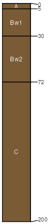
flood plains / Footslope flood plains / Toeslope
|
|
Glenberg (7%)
Sandy Lowland
Ustic Torrifluvents
Well drained
Hydric: No
PAWS: 20 cm |
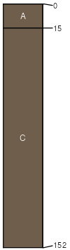
flood plains / Footslope flood plains / Toeslope
|
|
Valent (6%)
Sands
Ustic Torripsamments
Excessively drained
Hydric: No
PAWS: 14 cm |
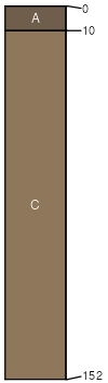
dunes / Summit dunes / Shoulder dunes / Backslope
|
|
Rock outcrop (2%)
Non-site
Excessively drained
Hydric: No
PAWS: 4 cm |

ledges / Shoulder ledges / Backslope
|
|