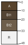
Butchhill gravelly loam, 15 to 45 percent slopes, stony
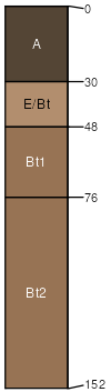
Butchhill
(80%)
Upland Alpine Group
Alfic Argicryolls
Well drained
Hydric: No
PAWS: 17 cm
hillslopes
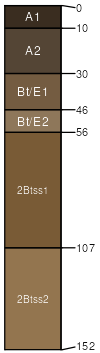
Butchhill
(4%)
Upland Sagebrush Shrubland Group
Alfic Argicryolls
Well drained
Hydric: No
PAWS: 17 cm
swales
Hairpin
(4%)
Upland Grassland
Vertic Argicryolls
Well drained
Hydric: No
PAWS: 25 cm
hillslopes
Adel
(4%)
Upland Shrubland Group
Pachic Haplocryolls
Well drained
Hydric: No
PAWS: 27 cm
hillslopes
Libeg
(4%)
Upland Sagebrush Shrubland Group
Ustic Argicryolls
Well drained
Hydric: No
PAWS: 13 cm
hillslopes
Nieman
(3%)
Shallow Shrubland Group
Lithic Argicryolls
Well drained
Hydric: No
PAWS: 3 cm
hillslopes
Rock outcrop
(1%)
Hydric:
PAWS: NA
SSA
Scale
Published
Export
mt610
1:24,000
2005
2025-08-30