Rockton (90%)
Shallow Upland
Typic Argiudolls
Well drained
Hydric: No
PAWS: 16 cm |
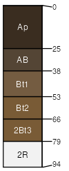
hills / Shoulder hills / Backslope
|
|
Plano (5%)
Loamy and Clayey Upland
Typic Argiudolls
Well drained
Hydric: No
PAWS: 27 cm |
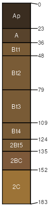
till plains / Shoulder till plains / Backslope
|
|
Griswold (3%)
Loamy and Clayey Upland
Typic Argiudolls
Well drained
Hydric: No
PAWS: 23 cm |
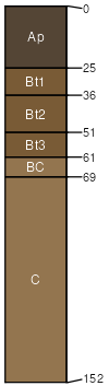
moraines / Shoulder moraines / Backslope
|
|
Edmund (2%)
Mollic Clayey Upland
Lithic Argiudolls
Well drained
Hydric: No
PAWS: 8 cm |
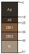
hills / Shoulder hills / Backslope
|
|